
Skyscan Forecast Thursday, June 23, 2022 Dan Hicks
Today: Partly cloudy. SSE @ 10. High 89.
Tonight: Partly cloudy. A few showers and thunderstorms. SE @ 5-10. Low 68.
Friday: Any showers and thunderstorms ending in the morning. Becoming partly cloudy. SE @ 10-15. High 89.
Friday Night: Showers and thunderstorms possible. Cloudy. SE @ 10-15. Low 69.
Saturday: Partly cloudy to cloudy. Scattered showers and thunderstorms. High 86.
Sunday: Partly cloudy. Cooler. High 80.
Yesterday’s high was 89 and the low was 60. This day last year we had a high of 89 and a low of 68. The all-time record high was 105 set in 1937 and the low was 44 in 1958. Sunrise this morning is 5:46 a.m. and sunset will be at 8:57 p.m.
Skyscan Forecast Wednesday, June 22, 2022 Dan Hicks
Today: Partly cloudy. NW @ 10. High 88.
Tonight: Partly cloudy. Light and variable winds. Low 63.
Thursday: Partly cloudy. Isolated showers and storms. SE @ 10. High 88.
Friday: Partly cloudy. Showers and t’storms in the morning. High 90.
Saturday: Partly cloudy to cloudy. Scattered showers and t’storms. High 86.
(Radio Iowa) – This (Tuesday) is the first day of summer and the continued hot, windy conditions are raising fears of flash droughts in Iowa and across the region. Meteorologist Dennis Todey, director of the U-S-D-A’s Midwest Climate Hub in Ames, says we’ve been seeing elevated temperatures for a few weeks already and that heat may soon start impacting Iowa corn and soybeans. Todey says, “Summer is hot but when you are warmer than average and have sunny skies, lots of wind, lower relative humidity, the atmosphere puts more demand or wants to use more water out of a crop.” A flash drought is the rapid onset or intensification of drought, brought on by all of the conditions we’re seeing.
Todey says it can appear — and spread — very fast. “That can add on problems very quickly, can add distress to a crop,” Todey says. “If you’ve got soil moisture to draw from, plants can handle this for a while. If your soil moisture is a bit more limited, the problems will show up sooner.”
The latest climate outlooks show warmer temperatures across Iowa and much of the Northern Plains into September. Soil moisture, he notes, is being depleted rapidly due to the hot, windy weather.
Adair-Madison-Adams-Union-Taylor-Ringgold Counties….HEAT ADVISORY IN EFFECT TODAY FROM NOON TO 7 PM.
* WHAT…Heat index values up to 105 expected.
* IMPACTS…Hot temperatures and high humidity may cause heat illnesses to occur. 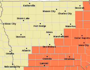
PRECAUTIONARY/PREPAREDNESS ACTIONS…
Drink plenty of fluids, stay in an air-conditioned room, stay out of the sun, and check up on relatives and neighbors. Young
children and pets should never be left unattended in vehicles under any circumstances.
Take extra precautions if you work or spend time outside. When possible reschedule strenuous activities to early morning or evening. Know the signs and symptoms of heat exhaustion and heat stroke. Wear lightweight and loose fitting clothing when possible. To reduce risk during outdoor work, the Occupational Safety and Health Administration recommends scheduling frequent rest breaks in shaded or air conditioned environments. Anyone overcome by heat should be moved to a cool and shaded location. Heat stroke is an emergency! Call 9 1 1.
Today: Partly cloudy w/isolated showers & thunderstorms possible. High 94. S-N @ 10-15.
Tonight: P/Cldy w/isolated shwrs & tstrms. Low 65. N @ 5.
Tomorrow: P/Cldy. High 88. N @ 10.
Thursday: P/Cldy w/isolated shwrs & tstrms. High 88.
Friday: P/Cldy w/shwrs & tstrms early. High 92.
Monday’s High in Atlantic was 95. Our Low this morning, 75. Last year on this date the High in Atlantic was 74 and the Low was 48. The Record High on this date was 101 in 1988. The Record Low was 38 in 1902.
Today: **Heat Advisory in effect from 10-a.m. until 10-p.m.**Sunny, with a high near 95. Heat index values as high as 103. Breezy, with a south wind 14 to 20 mph, with gusts as high as 25 mph.
Tonight: Mostly clear, with a low around 76. Breezy, with a south wind 13 to 20 mph, with gusts as high as 24 mph.
Tomorrow: Mostly sunny, with a high near 92. South southwest wind 11 to 15 mph becoming west northwest in the afternoon. Winds could gust as high as 21 mph.
Wednesday: Partly sunny, with a high near 87.
Thursday: A 30 percent chance of showers and thunderstorms. Mostly sunny, with a high near 89.
Sunday’s High in Atlantic was 93. Our Low this morning, 70. Last year on this date the High in Atlantic was 87 and the Low was 55. The Record High on this date was 101 in 1937 & 1988. The Record Low was 40 in 1961.
Sac-Crawford-Carroll-Audubon-Cass Counties
304 AM CDT Mon Jun 20 2022
…HEAT ADVISORY IN EFFECT FROM 11 AM THIS MORNING TO 10 PM CDT THIS EVENING…
* WHAT…Heat index values up to 105 expected.
* IMPACTS…Hot temperatures and high humidity may cause heat illnesses to occur.
Monona-Harrison-Shelby-Pottawattamie-Mills-Montgomery-Fremont-Page Counties
…HEAT ADVISORY REMAINS IN EFFECT UNTIL 10 PM CDT THIS EVENING…
* WHAT…Heat index values up to 108. 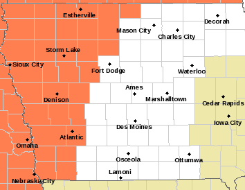
PRECAUTIONARY/PREPAREDNESS ACTIONS…
Drink plenty of fluids, stay in an air-conditioned room, stay out of the sun, and check up on relatives and neighbors. Young
children and pets should never be left unattended in vehicles under any circumstances.
Take extra precautions if you work or spend time outside. When possible reschedule strenuous activities to early morning or evening. Know the signs and symptoms of heat exhaustion and heat stroke. Wear lightweight and loose fitting clothing when possible. To reduce risk during outdoor work, the Occupational Safety and Health Administration recommends scheduling frequent rest breaks in shaded or air conditioned environments. Anyone overcome by heat should be moved to a cool and shaded location. Heat stroke is an emergency! Call 9 1 1.
Today: Sunny, with a high near 93. Heat index values as high as 100. Breezy, with a south wind 11 to 17 mph, with gusts as high as 23 mph.
Tonight: Mostly clear, with a low around 72. Breezy, with a south wind 10 to 16 mph, with gusts as high as 22 mph.
Monday: Sunny, with a high near 94. Heat index values as high as 100. Breezy, with a south wind 10 to 18 mph, with gusts as high as 26 mph.
Tuesday: Sunny, with a high near 93. South southwest wind 10 to 13 mph becoming west northwest in the afternoon. Winds could gust as high as 20 mph.
Tuesday Night: A 30 percent chance of showers and thunderstorms, mainly after 1am. Partly cloudy, with a low around 66. New rainfall amounts of less than a tenth of an inch, except higher amounts possible in thunderstorms.
Wednesday: A 30 percent chance of showers and thunderstorms before 1pm. Partly sunny, with a high near 84.
Saturday’s High in Atlantic was 92. Our Low this morning, 70. Last year on this date the High in Atlantic was 91 and the Low was 65. The Record High on this date was 104 in 1974. The Record Low was 42 in 1900.
Today: Mostly sunny & humids. High 88. SE winds @ 10-15 mph.
Tonight: Mostly clear. Low 71. SE @ 15.
Tomorrow: Sunny, hot & humid. High 92. S @ 10-20.
Monday: Sunny, hot & humid. High 94. S @ 15-25.
Tuesday: P/Cldy. High 89. SW @ 10-15.
Friday’s High in Atlantic was 91. Our Low this morning, 67. Last year on this date the High in Atlantic was 88 and the Low was 64. The Record High on this date was 98 in 1910. The Record Low was 46 in 1974 & 2000.
Today: Partly cloudy. High near 89. E/NE winds @ 5-10 mph.
Tonight: P/Cldy. Low around 68. E @ 5.
Tomorrow: P/Cldy. High 91. SE @ 10.
Sunday: P/Cldy. High 93.
Monday: P/Cldy. High 96.
Thursday’s High in Atlantic was 89. The Low was 62. Last year on this date the High in Atlantic was 102 and the Low was 69. The Record High was 102 in 1918 & 2021. The Record Low was 40, in 1974. (We will update any rainfall in our gauge after sunrise/before 6-a.m.)


