
(Cass County, Iowa – 7/18/2022) – Cass County Emergency Management Coordinator Mike Kennon reports, that with excessive heat expected to persist through this workweek, facilities in Cass County have opened their doors to people who need a break from the extreme heat.

The National Weather Service has indicated that we are heading into a stretch of very hot and humid conditions for the region. Heat index values could approach 95 to 105 degrees on Tuesday. Kennon says he would like to thank the YMCA and area libraries for providing this important service.
”Drink plenty of fluids, avoid strenuous outdoor activity during the heat of the day and check on relatives, neighbors, the elderly and pets. Anyone overcome by heat should be moved to a cool and shaded location. Heat stroke is an emergency…call 9-1-1.”
DES MOINES – As part of an effort to develop a statewide drought preparedness plan, the Iowa DNR and partners will host three of four public stakeholder meetings this week, and a virtual meeting in August to gather ideas and input. DNR’s coordinator of hydrology resources Tim Hall says “Iowa has been through significant droughts in 1988, 2012 and 2021. While the state responded well to those events, a statewide drought plan would allow for better coordination between agencies, better communication, and improved response.”
A number of state agencies have come together to develop such a drought plan for Iowa, including the Iowa Department of Agriculture and Land Stewardship and the Iowa Department of Homeland Security and Emergency Management. An important part of drought planning efforts is the collection of ideas and experiences from Iowans. To gather information, the agencies will host a series of public stakeholder meetings. A meeting was held July 6th, in Iowa Falls, and another is set for July 21st, in Cedar Rapids.
An Online-only meeting will be held 9-a.m. Aug. 3rd. Details on the virtual session will be released closer to the meeting date. In western Iowa, the drought plan meetings will be held in:
Monthly reports on drought conditions in Iowa can be found in the Water Summary Update.
Today: Mostly sunny. High 92. SW winds @ 10-20 mph.
Tonight: Fair to partly cloudy. Low around 70. S @ 5-10.
Tomorrow: P/Cldy. High near 95. SW-NW @ 10-20.
Wednesday: Mo. Sunny. High near 90.
Thursday: P/Cldy. High 92.
Sunday’s High in Atlantic was 88. Our Low this morning, 60. Last year on this date the High in Atlantic was 85 and the Low was 57. The Record High on this date was 107 in 1936. The Record Low was 44 in 1953.
Today: Cloudy through mid morning, then gradual clearing, with a high near 84. Northeast wind 3 to 7 mph.
Tonight: Mostly clear, with a low around 64. North northeast wind 5 to 7 mph becoming calm in the evening.
Tomorrow: Sunny, with a high near 90. Calm wind becoming south southwest 5 to 8 mph in the afternoon.
Monday Night: Mostly clear, with a low around 68.
Tuesday: Sunny, with a high near 95. Breezy.
Wednesday: Sunny, with a high near 90. Breezy.
Saturday’s High in Atlantic was 79. Our Low this morning, 69. Last year on this date the High in Atlantic was 83 and the Low was 57. The Record High on this date was 109 in 1926. The Record Low was 45 in 1911.
Today: Mostly cloudy. High 84. NE @ 10 mph.
Tonight: Cldy w/a 10% chance of rain. Low 68. NE @ 5-10.
Tomorrow: Cldy in the morning w/clearing skies during the day. High 87. NE @ 10.
Monday: Sunny. High 91.
Tuesday: Mostly sunny & hot. High around 100. SW @ 10-20mph.
Friday’s High in Atlantic was 92. Our Low this morning, 73. Last year on this date the High in Atlantic was 83 and the Low was 59. The Record High on this date was 109 in 1936. The Record Low was 45 in 1906.
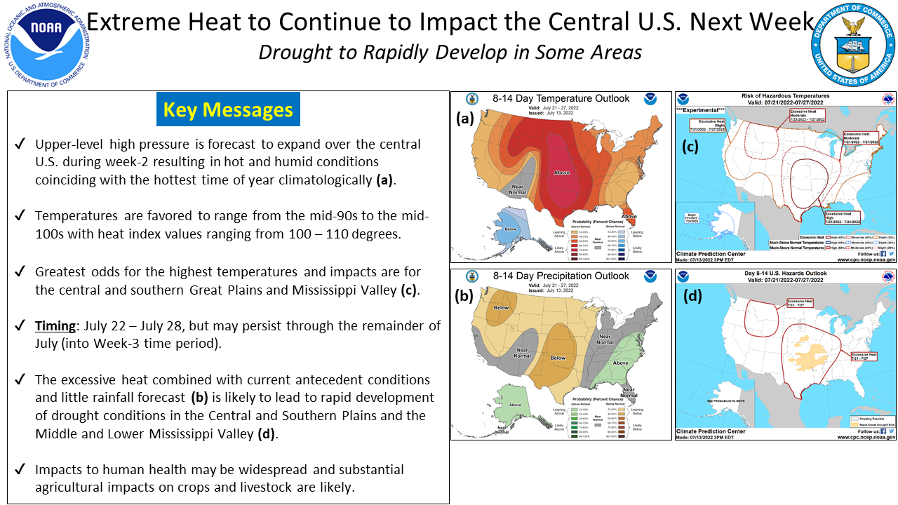
(Omaha, NE) – Officials with the National Weather Service warn, that with the heat and dry weather, “rapid onset drought” conditions may develop quickly in parts of eastern Nebraska and western Iowa. Expect the hot weather conditions to continue for about the next two weeks.
Pottawattamie-Mills-Fremont-Page Counties…
…HEAT ADVISORY IN EFFECT FROM 1 PM THIS AFTERNOON TO 8 PM CDT THIS EVENING…
* WHAT…Heat index values up to 105 expected.
* IMPACTS…Hot temperatures and high humidity may cause heat illnesses to occur.
PRECAUTIONARY/PREPAREDNESS ACTIONS…
Drink plenty of fluids, stay in an air-conditioned room, stay out of the sun, and check up on relatives and neighbors. Young children and pets should never be left unattended in vehicles
under any circumstances.
Take extra precautions if you work or spend time outside. When possible reschedule strenuous activities to early morning or evening. Know the signs and symptoms of heat exhaustion and heat stroke. Wear lightweight and loose fitting clothing when possible. To reduce risk during outdoor work, the Occupational Safety and Health Administration recommends scheduling frequent rest breaks in shaded or air conditioned environments. Anyone overcome by heat should be moved to a cool and shaded location.
Heat stroke is an emergency! Call 9 1 1.
Today: Partly cloudy. High 94. SW wind @ 10-20 mph becoming NW this afternoon
Tonight: P/Cldy. Low 68. N @ 5-10.
Tomorrow: P/Cldy w/scattered late day showers & thunderstorms. High around 90. E @ 10.
Sunday: A chance of shwrs/tstrms in the morning; P/Cldy. High 92.
Monday: P/Cldy. High 94.
Thursday’s High in Atlantic was 90. Our Low was 65. Last year on this date the High in Atlantic was 86 and the Low was 57. The Record High on this date was 110 in 1936. The Record Low was 42 in 1930.
Today: Partly cloudy. High 92. SE wind @ 10-15 mph.
Tonight: P/Cldy w/scattered showers & thunderstorms developing late. Low 72. S @ 10.
Tomorrow: Showers & thunderstorms ending; P/Cldy. High 94. SW @ 10-20 shifting to the North, late.
Saturday: P/Cldy w/late day showers and thunderstorms. High around 92.
Sunday: P/Cldy w/scattered showers and thunderstorms early. High near 92.
Wednesday’s High in Atlantic was 88. Our Low was 58. Last year on this date the High in Atlantic was 86 and the Low was 67. The Record High on this date was 112 in 1936. The Record Low was 41 in 1967.
Today: Mostly Sunny, with a high 88. SE wind 5 to 10 mph.
Tonight: Fair to partly cloudy. Low 65. SE @ 5.
Tomorrow: P/Cldy. High near 90. S @ 10-15.
Friday: P/Cldy w/a chance of morning showers and thunderstorms. High around 92.
Saturday: P/Cldy w/scattered showers and thunderstorms. High near 92.
Tuesday’s High in Atlantic was 85. Our Low this morning, 57. Last year on this date, the High in Atlantic was 83 and the Low was 56. The Record High was 108 in 1936, and the Record Low was 44, in 1897.


