
Today: Mostly sunny, with a high near 85. Calm wind becoming south around 5 mph in the afternoon.
Tonight: Mostly clear, with a low around 63. South wind 3 to 5 mph.
Wednesday: Mostly sunny, with a high near 87. South southwest wind 5 to 11 mph, with gusts as high as 18 mph.
Wednesday Night: A slight chance of showers, with thunderstorms also possible after 1am. Partly cloudy, with a low around 63. South southwest wind 3 to 8 mph. Chance of precipitation is 20%.
Thursday: A 20 percent chance of showers and thunderstorms after 1pm. Mostly sunny, with a high near 85.
Friday: Mostly sunny, with a high near 82.
Monday’s High in Atlantic was 83. Our Low was 56. Last year on this date the High in Atlantic was 95 and the Low was 75. The Record High on this date was 99 in 1894. The Record Low was 36 in 1891.
Today: Areas of dense fog this morning; Becoming mostly sunny. High 85. S @ 5-10.
Tonight: Fair to P/Cldy. Low 60. S @ 5.
Tomorrow: Mo. Sunny. High 87. S @ 10-15.
Wednesday: P/Cldy w/a chance of thunderstorms late. High near 90.
Thursday: P/Cldy w/scattered shwrs & tstorms. High 84.
Sunday’s High in Atlantic was 83. Our Low this morning, 56. Last year on this date the High in Atlantic was 85 and the Low was 55. The Record High on this date was 100 in 1914. The Record Low was 41 in 1904.
Crawford-Carroll-Greene-Audubon-Guthrie-Dallas-Cass-Adair-Madison-Adams-Union-Taylor-Ringgold-Monona-Harrison-Shelby-Pottawattamie-Mills-Montgomery-Fremont-Page-Counties…
315 AM CDT Mon Aug 22 2022
…Areas of Fog This Morning Over Central Iowa…
Fog has developed in low lying areas and in river valleys early this Monday morning. Some locations have visibility occasionally dropping below one-quarter mile at times. The fog is expected to remain over the region through the morning commute and may become more widespread; possibly lasting to mid-morning over most of the region. Patchy dense fog with variable visibility can be expected this morning. Please be aware of rapidly changing visibility this
morning. 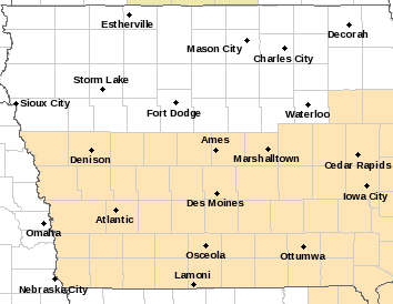
If you will be out traveling early today or will be commuting to work between 4 AM and 9 AM today; allow extra time to reach your destination safely. Use low-beam headlights and allow extra stopping distance between you and other vehicles if dense fog is encountered.
Today: Sunny, with a high near 81. North wind 3 to 7 mph.
Tonight: Mostly clear, with a low around 57. North northeast wind around 6 mph becoming calm in the evening.
Monday: Sunny, with a high near 82. Calm wind becoming northeast around 5 mph in the afternoon.
Monday Night: Mostly clear, with a low around 58. Light southeast wind.
Tuesday: Mostly sunny, with a high near 85. Calm wind becoming south around 6 mph in the morning.
Tuesday Night: Mostly clear, with a low around 61.
Wednesday: Sunny, with a high near 87.
Saturday’s High in Atlantic was 79. We received some drizzle through mid-morning (Trace of rain). The Low was 58. Last year on this date, the High in Atlantic was 77 and the Low was 54. The Record High on this date was 100, in 1936. The Record Low was 40, in 1956.
(Des Moines, Iowa) – Hail ranging in size from dimes and ping-pong balls, to apples, fell across parts of central Iowa Friday afternoon, and heavy rain flooded the streets of Des Moines, catching motorists off-guard and resulting in stalled vehicles. Iowa State Fair officials ordered visitors to the fair to take shelter as the storms passed over the venue at around 2:30-p.m.
Hail reportedly damaged the roof at Valley High School in West Des Moines, flooding the school’s gymnasium. Hail as large as 2 to 3 inches in diameter was reported.
Many vehicle owners reported their windshields and other windows were shattered, and their cars were dented or dimpled, in Clive and West Des Moines. Heavy rain caused flooding at 24th and Hickman, in Des Moines. One motorist who didn’t heed the “Turn around, don’t drown,” message, found themselves stranded in the middle of the intersection, and requiring help from rescue crews. Water surrounded the car up to its hood, according to social media reports.
Ping-pong ball size hail was reported near Grundy Center, with quarter-size hail falling near Steamboat Rock and Holland. There were no reports of injuries.
Today: Mostly cloudy. High 79. NW @ 10.
Tonight: P/Cldy. Low 590. N @ 5-10.
Tomorrow: Mo. Sunny. High 83. N @ 10-15.
Monday: Mo. Sunny. High 83. E @ 5.
Tuesday: Mo. Sunny. High 93. SE @ 10-15.
Friday’s High in Atlantic was 84. We received .09″ rain from Friday into this (Saturday) morning. Our Low was 60. Last year on this date the High in Atlantic was 92 and the Low was 62. The Record High on this date was 100 in 1947. The Record Low was 36 in 1897.
Today: Partly cloudy w/scattered afternoon showers & tstrms. High 87. NW @ 10-15.
Tonight: P/Cldy to Cldy w/scattwered showers & thunderstorms. Low 60. NW @ 5-10.
Tomorrow: Morning showers possible; Becoming P/Cldy. High 80. NW @ 10-15.
Sunday: Mo. Sunny. High 83.
Monday: P/Cldy. High 86.
Thursday’s High in Atlantic was 83. Our Low was 57. Rainfall overnight Thursday into early today amounted to .12″ at KJAN. Last year on this date the High in Atlantic was 89 and the Low was 68. The Record High on this date was 100 in 1947. The Record Low was 41 in 1981.
(Radio Iowa) – Despite widespread rainfall earlier this week, drought conditions are worsening across Iowa, according to the new map out today (Thursday) from the U-S Drought Monitor. Field agronomist Rebecca Vittetoe, with the Iowa State University Extension, says the new red spots on the map are particularly troubling. “It just got updated again this morning based off of rainfall as of Tuesday morning of this week,” Vittetoe says, “so, not necessarily major changes on the Drought Monitor but parts of western Iowa, there’s a few more areas that are in the D-3 or that extreme drought compared to last week.”
Extreme drought is now shown in five western counties: Cherokee, Monona, Plymouth, Sioux and Woodbury, while statewide, 67 counties are now in some form of drought, up from 64 counties last week. Vittetoe is based in southeast Iowa’s Washington County, which is listed as both abnormally dry and in moderate drought, and she’s encouraged by crop conditions as harvest season nears. “It’s amazing what the plant breeders have been able to do to help crops better withstand drought,” Vittetoe says. “I look at some fields that have had less than five inches of rainfall this growing season and I’m impressed with how well they look, considering the little rainfall that we have had.”
She says Iowa’s two biggest crops are suffering fairly equally in the drought. “On the corn side, that pollination and grain fill is a really critical period when we don’t want to be having a lot of drought stress. We want to have plenty of moisture, cooler temperatures, to really help with pollination and with grain fill,” Vittetoe says. “On the soybean side, if we’re hot and dry in July, when that corn’s pollinating, I’m not as concerned then as when we get into August and we’re trying to work on putting on pods, filling pods.”
Vittetoe will be hosting a statewide virtual meeting next on the drought from the fall harvest perspective. For details, visit: https://www.aep.iastate.edu/drought/view
Today: Partly cloudy. High 86. S @ 10-15.
Tonight: P/Cldy w/scattwered showers & thunderstorms. Low 65. S @ 5-10.
Tomorrow: P/Cldy to cldy w/scatt. Shwrs & tstrms. High 80. NW @ 10-15.
Saturday: Mo. Cldy w/scattered showers/thunderstorms. High 78.
Sunday: P/Cldy. High 82.
Wednesday’s High in Atlantic was 85. Our Low this morning, 56. Last year on this date the High in Atlantic was 87 and the Low was 68. The Record High on this date was 111 in 1936. The Record Low was 40 in 2012.
Today: Patchy fog early; Mostly sunny. High 82. E @ 10.
Tonight: Fair to P/Cldy. Low 58. SE @ 5.
Tomorrow: P/Cldy. High 84. S @ 10.
Friday: P/Cldy w/scattered showers/thunderstorms. High 80.
Saturday: P/Cldy w/scattered shwrs & tstrms. High 78.
Tuesday’s High in Atlantic was 83. Our Low this morning, 58. Last year on this date the High in Atlantic was 89 and the Low was 64. The Record High on this date was 108 in 1936. The Record Low was 38 in 1897.


