
Today: Partly cloudy. High 62. W/NW winds @ 10-20 mph.
Tonight: P/Cldy. Low 30. NW @ 5-10.
Tomorrow: P/Cldy. High 64. W @ 10-15.
Sunday: P/Cldy. High near 60.
Monday: P/Cldy. High 55.
Thursday’s High in Atlantic was 56. Our Low was 30. Last year on this date the High in Atlantic was 66 and the Low was 40. The Record High on this date was 88 in 1897. The Record Low was 16 in 1937.
Today: **Red Flag Warning this afternoon**Partly cloudy. High 59. W/NW winds @ 15-30 mph+.
Tonight: Fair to P/Cldy. Low 32. NW @ 5-10.
Tomorrow: P/Cldy. High 62. W @ 10-20.
Saturday: P/Cldy. High 64.
Sunday: P/Cldy. High 62.
Wednesday’s High in Atlantic was 68. Our Low this morning, 43. Last year on this date the High in Atlantic was 71 and the Low was 42. The Record High on this date was 88 in 1975. The Record Low was 15 in 1907.
Harrison-Shelby-Pottawattamie-Mills-Fremont-Washington-Douglas-
Sarpy-Lancaster-Cass-Otoe-Saline-Jefferson-Gage-Johnson-Nemaha-
Pawnee-Richardson-
1033 AM CDT Wed Oct 12 2022

...RED FLAG WARNING IN EFFECT UNTIL 7 PM CDT THIS EVENING FOR
WIND AND LOW RELATIVE HUMIDITY FOR EASTERN NEBRASKA AND FAR
WESTERN IOWA...
...FIRE WEATHER WATCH REMAINS IN EFFECT FROM THURSDAY AFTERNOON
THROUGH THURSDAY EVENING FOR WIND AND LOW RELATIVE HUMIDITY FOR
EASTERN NEBRASKA AND FAR WESTERN IOWA...

The National Weather Service in Omaha/Valley has issued a Red
Flag Warning for wind and low relative humidity, which is in
effect until 7 PM CDT this evening.

* Affected Area...In Iowa, Harrison, Shelby, Pottawattamie,
  Mills and Fremont. In Nebraska, Washington, Douglas, Sarpy,
  Lancaster, Cass, Otoe, Saline, Jefferson, Gage, Johnson,
  Nemaha, Pawnee and Richardson.

* Winds...Northwest 15 to 25 mph with gusts up to 40 mph.

* Relative Humidity...As low as 21 percent.

* Impacts...Any fires that ignite may spread rapidly and exhibit
  extreme fire behavior. Use extreme caution if engaging in any
  activities that could start a fire. Outdoor burning is not
  advisable.

PRECAUTIONARY/PREPAREDNESS ACTIONS...

A Red Flag Warning means that critical fire weather conditions
are either occurring now, or will shortly. A combination of
strong winds, low relative humidity and warm temperatures can
contribute to extreme fire behavior.

A Fire Weather Watch means that critical fire weather conditions
are forecast to occur. Listen for later forecasts and possible
Red Flag Warnings.
Special Weather Statement from the National Weather Service Des Moines IA for the following area Counties: Sac-Crawford-Carroll-Audubon-Guthrie-Dallas-Cass-Adair-Madison-Adams-Union-Taylor-Ringgold
…Gusty Winds and Elevated Fire Danger Today and Tomorrow…
Northwest winds are expected to increase into the afternoon both today and tomorrow with gusts reaching 30 to 40 mph, and possibly higher at times. These winds will also be coincident with lower relative humidities resulting in elevated fire weather conditions where fires may develop and spread quickly.
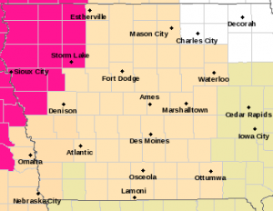
Red Flag Warning (counties in pink); Fire Weather Watch (tan); Special Wx Statement (light brown/flesh color).
Open burning is discouraged and farmers are urged to be cautious during harvest activities. Gusty winds may blow around unsecured objects, such as Halloween decorations.
Harrison-Shelby-Pottawattamie-Mills-Fremont Counties ..
A FIRE WEATHER WATCH IS IN EFFECT FROM NOON TODAY THROUGH THIS EVENING FOR WIND AND LOW RELATIVE HUMIDITY FOR PORTIONS OF SOUTHEAST NEBRASKA AND WESTERN IOWA… …A FIRE WEATHER WATCH REMAINS IN EFFECT FROM THURSDAY AFTERNOON THROUGH THURSDAY EVENING FOR WIND AND LOW RELATIVE HUMIDITY FOR MOST OF EASTERN NEBRASKA AND SOUTHWEST IOWA. ( https://www.weather.gov/dmx/)
* Winds…Northwest 15 to 25 mph with gusts up to 40 mph.
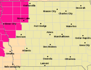
Fire Weather Watch (counties in flesh color); Red Flag Warning (Counties in pink).
* Relative Humidity…As low as 20 percent.
* Impacts…Any fires that ignite may spread rapidly and exhibit extreme fire behavior. Use extreme caution if engaging in any activities that could start a fire. Outdoor burning is not advisable.
PRECAUTIONARY/PREPAREDNESS ACTIONS… A Fire Weather Watch means that critical fire weather conditions are forecast to occur. Listen for later forecasts and possible Red Flag Warnings.
Today: Partly cloudy to cloudy. High 65. NW winds @ 15-30 mph+.
Tonight: P/Cldy. Low 37. NW @ 10-15+.
Tomorrow: P/Cldy. High 59. NW @ 10-15.
Friday: P/Cldy. High 64. Windy.
Saturday: P/Cldy. High 62.
Tuesday’s High in Atlantic was 80. Rainfall overnight amounted to .43″ (as of 5:30-a.m.). Our Low this morning (as of 5-a.m.) was 54. Last year on this date the High in Atlantic was 79 and the Low was 37. The Record High on this date was 90 in 1899. The Record Low was 17 in 1908.
Today: Partly cloudy. High near 80. SW winds @ 10-20 mph.
Tonight: Showers & some thunderstorms are possible. Low around 50. S-NW @ 10-15.
Tomorrow: P/Cldy & cooler. High 65. NW @ 10-20.
Thursday: P/Cldy. High 59. Windy.
Friday: P/Cldy. High 62.
Monday’s High in Atlantic was 80. Our Low was 32. Last year on this date the High in Atlantic was 71 and the Low was 37. The Record High on this date was 93 in 1893. The Record Low was 17 in 1987.
Today: Partly cloudy. High 78. S winds @ 10-15 mph.
Tonight: P/Cldy. Low 50. S @ 5-10.
Tomorrow: P/Cldy. High 80. SW @ 10-20 mph. Tues. Night: A chance of showers & thunderstorms. Low around 48.
Wednesday: P/Cldy. High 62.
Thursday: P/Cldy. High 59.
Sunday’s High in Atlantic was 77. Our Low was 29. Last year on this date the High in Atlantic was 68 and the Low was 54. The Record High on this date was 96 in 1895. The Record Low was 17 in 1906.
Today: Sunny, with a high near 74. Light southwest wind becoming west 8 to 13 mph in the morning. Winds could gust as high as 18 mph.
Tonight: Mostly clear, with a low around 41. Northwest wind around 5 mph becoming calm in the evening.
Columbus Day: Sunny, with a high near 78. Light south southeast wind becoming south 5 to 10 mph in the afternoon.
Monday Night: Mostly clear, with a low around 53. South wind 6 to 8 mph, with gusts as high as 18 mph.
Tuesday: A slight chance of showers between 1pm and 4pm, then a slight chance of showers and thunderstorms after 4pm. Mostly sunny, with a high near 78. Windy, with a south southwest wind 10 to 15 mph increasing to 16 to 21 mph in the afternoon. Winds could gust as high as 29 mph. Chance of precipitation is 20%.
Tuesday Night: A 50 percent chance of showers and thunderstorms. Partly cloudy, with a low around 49. New rainfall amounts between a tenth and quarter of an inch, except higher amounts possible in thunderstorms.
Wednesday: A slight chance of thunderstorms before 7am. Mostly sunny, with a high near 67. Breezy. Chance of precipitation is 10%.
Saturday’s High in Atlantic was 65. The Low was 22. Last year on this date, our High was 75 and the Low was 56. The Record High for this date, was 87 in 1930, 1938, & 2020. The Record Low was 14, in 2000.


