
Today: Mostly sunny. High 51. W @ 10 mph.
Tonight: Fair to partly cloudy. Low 30. SW @ 5.
Tomorrow: P/Cldy. High 64. W/SW @ 10-20.
Friday: P/Cldy. High 73.
Saturday: P/Cldy. High 75.
Tuesday’s High in Atlantic was 43. Our Low this morning, 13 (that beats the old, 24-hour Low of 17 set in 1952). Last year on this date the High in Atlantic was 76 and the Low was 52. The Record High on this date was 88 in 2003. The Record Low was 12 in 1972.
(Radio Iowa)/KJAN) – It’ll be one of those weeks in Iowa where our attire may include both winter coats and shorts. This (Tuesday) morning, some communities experienced lows in the low 20s and wind chills below zero. Meteorologist Ashley Bury, at the National Weather Service in Johnston, says four Iowa cities had record low temperatures early today. “We had 21 degrees at the Des Moines airport, which beat 22 degrees that we had in 1972,” Bury says. “At Lamoni, it was also 22 and Ottumwa was 22, which beat the records in 1972 when their lows were also 23. So just a degree lower for those three sites, but that did break our record today.”
In Atlantic, the 24-hour Low ending at 7-a.m. was not a record breaker, but after 7-a.m., we dropped to 16 degrees, and that broke the old record for Oct. 18th, which was 17 degrees, set in 1952. The forecast is calling for an overnight Low of around 15, so the record Low statistic may change again. Webster City broke a 70-year-old record this morning with 16 degrees, besting a record of 18 set on this date in 1952. If we can endure a little more cold, Bury says warmer weather is coming. “Another chilly night tonight, mainly in the low 20s again, maybe some upper teens, no records look like they’re going to be broken though,” she says, “but after that, we’re going to see some highs back in the 50s and even by the end of the week, Friday into the weekend, we’re going to see temperatures even in the 70s, so it’s gonna be nice and warm for October.”
While today’s highs are mostly in the low 40s, highs by Saturday may be near 80.
(Radio Iowa) – Harvest season is underway in Iowa with drought conditions ranging from severe to extreme — and forecasts show those conditions will likely continue well into winter. Meteorologist Dennis Todey, director of the U-S-D-A’s Midwest Climate Hub in Ames, says there are a few benefits to the dry weather, like how the tractors aren’t getting mired in mud. “People, when they’re ready to harvest, are going to be able to get out and harvest because there’s nothing really slowing them down,” Todey says, “though the thing that may slow them down in some cases is that beans may be too dry or something like that. I was hearing people waiting until the evening when it’s a little more humid to do some harvesting.” Todey says the soil continues to dry out and dry deeper across wide sections of Iowa.
“Soils are very dry at this point,” he says, “so soil moisture recharge is a concern and a very serious concern because of some dryness expanding all the way back into 2021 that we didn’t quite recover from completely.” Todey says there are a number of harvest time hazards for farmers and passing motorists due to the dry conditions. “I was driving through southern Minnesota last night and somebody was doing a bean field that looked like there was a fog over the bean field because there was so much dust kicked up,” he say. “I saw somebody tweet, too, that it was a good thing that they had auto-steer because I’m not sure they could see where they were going because of the dust that’s being kicked up. So, multitude of problems because of very severe drought.”
Many locations in Iowa are now showing six-to-eight-inch precipitation deficits for the year.
Today: Mostly sunny. High 44. N/NW winds @ 15-25 mph.
Tonight: Mostly clear. Low 15.
Tomorrow: Mostly sunny. High 52. W @ 10-15.
Thursday: Partly cloudy. High 62.
Friday: P/Cldy. High near 72.
Monday’s High in Atlantic was 46. Our Low this morning, 16. Last year on this date the High in Atlantic was 75 and the Low was 38. The Record High on this date was 86 in 2003. The Record Low was 17 in 1952.
AMES, Iowa – Oct. 17, 2022 – There’s an unmistakable chill in the air as fall slowly creeps into winter. Keeping roads in their best shape to ensure you get where you want to go, no matter the season is the goal of employees with the Iowa Department of Transportation. As the weather changes, their focus is keeping the roads as clear as possible and giving you the information you need to make smarter, safer travel decisions.
What you can do to prepare for the months ahead:
Winterize your vehicle – To minimize the possibility of a breakdown, get your vehicle tuned up. Check your vehicle’s wipers, hoses, battery, alternator, belts, tires, brakes, exhaust system, lights, and fluid levels. Make sure your vehicle’s heater and defroster are in good working order and you travel with plenty of gas in your tank. A breakdown is frustrating on a good day but can be dangerous during wintry weather.
Place a winter survival kit in your vehicle – This kit should contain items to help sustain your life and the lives of your passengers should your vehicle become stranded during inclement weather. These items can include booster cables; a flashlight with fresh batteries; extra blankets and warm clothes; nonperishable, high-calorie food items; candles, matches, a can for melting snow for drinking water, and a snow shovel. Sufficient supplies should be in the kit for all persons traveling in the vehicle. Carrying a mobile phone and charger in your vehicle is also advised for use during an emergency.
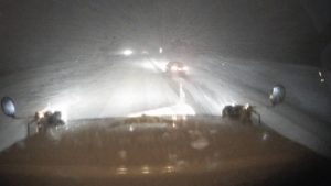
DOT Snow plow cam on I-80 near Atlantic. (FILE PHOTO)
Use technology to help make better travel decisions – The winter road conditions layer is now visible on www.511ia.org. This layer, along with layers that show images directly from the windshields of our snowplows and stationary cameras along the roadside, can help you determine whether it is safe to travel now or if you should postpone your trip.
Kick your winter driving skills into gear – The first snowfall and slick roads are a quick reminder that it’s time to re-evaluate and adjust your driving behaviors.
How the Iowa DOT has prepared:
Our people and equipment – The department’s 101 maintenance garages employ 1,083 full-time equipment operators, mechanics, and supervisors, and are in the process of hiring up to 633 temporary employees this winter season, to keep the agency’s 902 trucks, 42 motor graders, 32 tow plows, and 10 heavy-duty, self-propelled snowblowers on the road during winter weather.
For those interested in temporary, part-time snowfighter positions, go to https://iowadot.gov/careers and click on the “seasonal/temp” tab.
The materials we use – The Iowa DOT has spent the warmer months stocking salt in our storage facilities for use during the winter. Buying during the spring and summer allows us to obtain better pricing because demand is low. On average, the Iowa DOT uses more than 144,00 tons of salt and nearly 33 million gallons of brine each year to help maintain safe travel on the primary highway system, consisting of interstate, U.S., and Iowa routes.
The Iowa DOT primarily uses salt brine, a simple solution of standard rock salt and water, to help with winter roadway maintenance. It can be used to pretreat roadways before a storm, thus preventing snow and ice from bonding to the pavement. Brine is also used to prewet salt before it leaves the truck, increasing its ability to melt snow and ice and helping keep it on the roadway surface.
You may wonder why Iowa DOT trucks sometimes spray brine on sunny days. Frost is a major safety factor this time of year. The Iowa DOT’s proactive approach of spraying brine on areas prone to frost prevents the formation of an icy layer, which typically occurs on cold, clear nights. Frost is hard to see on the road’s surface and most people don’t expect it. These unexpected encounters with a frost-covered bridge or roadway can be particularly treacherous when traveling at higher rates of speed, making it more difficult to maintain control of your vehicle.
For more information about winter preparedness and the Iowa DOT’s snow and ice control program, check the Iowa DOT’s winter safety website.
Today: Partly cloudy. High 46. N/NW winds @ 15-25 mph.
Tonight: Mostly clear. Low 18. N @ 5-10.
Tomorrow: Mostly sunny. High 44. N @ 10-15.
Wednesday: Mo. sunny. High 52.
Thursday: P/Cldy. High 62.
Sunday’s High in Atlantic was 58. Our Low this morning, 27. Last year on this date the High in Atlantic was 73 and the Low was 33. The Record High on this date was 87 in 1947 & 2016. The Record Low was 12 in 1976.
Today: Mostly sunny, with a high near 55. Breezy, with a northwest wind 5 to 10 mph increasing to 13 to 18 mph in the afternoon. Winds could gust as high as 26 mph.
Tonight: Mostly clear, with a low around 26. North northwest wind 6 to 9 mph, with gusts as high as 18 mph.
Monday: Sunny, with a high near 43. Breezy, with a north northwest wind 8 to 18 mph, with gusts as high as 25 mph.
Tuesday: Sunny, with a high near 42. North northwest wind 6 to 13 mph, with gusts as high as 20 mph.
Wednesday: Sunny, with a high near 52.
Yesterday’s high was 70 and the low was 29. This day last year the high was 64 and the low was 33. The all-time record high was 87 set in 1921. The record low was 20 in 1976 & 1977. Sunrise is at 7:33 a.m. and sunset will be at 6:38 p.m.
Skyscan Forecast Saturday, October 15, 2022 Dan Hicks
Today: Partly cloudy. W @ 10-20. High 65.
Tonight: Partly cloudy. NW @ 5-10. Low 34.
Sunday: Partly cloudy. W @ 10-20. High 65.
Sunday Night: Clear. NNW @ 5-10. Low 27.
Monday: Partly cloudy. NNW @ 5-15. High 50.
Tuesday: Partly cloudy. High near 50.
Yesterday’s high was 58 and the low was 23. This day last year the high was 66 and the low was 36. The all-time record high was 89 set in 1892. The record low was 17 in 1952. Sunrise is at 7:31 a.m. and sunset will be at 6:39 a.m.
(Western Iowa) – Crews in western and southwest Iowa kept busy Thursday afternoon, battling the wind and flames that spurred two separate large field fires. The fires occurred within a couple of hours of one another. One of the incidents involved a soybean field in northwestern Audubon County. Firefighters from Manning, Manilla, Irwin, Defiance, Kirkman, and Audubon responded to the scene. Shelby County Emergency Management noted on their social media page, that “It was fast moving,” and that crews “did a GREAT job stopping it from getting to the next field of standing corn!!!!”
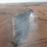
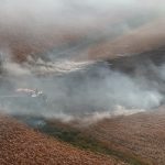
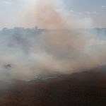
Click on the images to enlarge

Photos via Shelby County EMA Facebook page
Henderson, Emerson, Hastings, Stanton firefighters were paged out Thursday, to the area of Highway 34 and A Avenue in Montgomery County, where a large corn field fire was occurring. Some equipment was burning in that incident as well. Crews battled the flames for at least three hours before they were brought under control.
No injuries were reported from either incident.
(Des Moines, Iowa) – The latest U-S Drought Monitor report shows conditions worsening across Iowa. The report, issued Thursday, said 100% of Iowa is experiencing abnormally dry conditions, marking the first time since August 2013 that all of the state has had some sort of drought designation. 57% of Iowa is experiencing moderate drought, an increase from 52% just a week ago, while 27% of Iowa is dealing with severe drought. 7% of Iowa has extreme drought. Plymouth, Cherokee, Buena Vista and Pocahontas Counties, along with parts of seven other counties in northwest Iowa, are included in the Extreme Drought conditions.
Cass and Adair Counties are in a moderate drought, as is much of Madison County and most of Pottawattamie County. Half of the counties to our south are Moderately or Abnormally Dry. Most of the counties adjacent to Cass and to the north of I-80 are also Abnormally Dry. There were two separate, large field fires Thursday afternoon in southwest/western Iowa.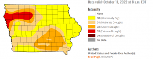
As was the case in August 2022, much of the Des Moines metro is experiencing moderate drought, while cities like Albia, Centerville, Chariton, Grinnell, Indianola, Newton, Osceola, Oskaloosa and Ottumwa are dealing with severe drought.
Ongoing drought, low relative humidity, and strong winds are contributing to heightened fire danger across the state. The long-term weather pattern does not favor any sort of drought-busting weather, as there are only limited rain chances in the extended forecast. Meaningful rainfall would be beneficial before winter arrives, otherwise much of Iowa will enter spring planting season with significant drought concerns.
New reports are issued by the U.S. Drought Monitor each Thursday. The updates account for any rain that has fallen through the Tuesday prior to each report’s release.


