
Today: Mostly cloudy. High around 29. N/NW winds @ 15-25 mph. Wind chill values as low as 10.
Tonight: Fair to partly cloudy. Low around 10. NW winds diminishing to around 5-10 mph.
Tomorrow: Partly cloudy. High 32. SE @ 5-10.
Saturday: Partly cloudy. High near 48.
Sunday: Partly cloudy. High near 50.
Wednesday’s High in Atlantic was 33. Our Low this morning, 26. Last year on this date, the High in Atlantic was 55 and the Low was 23. The All-Time Record High was 57 in 1961 & 1987. The Record Low was -37 in 1974. Sunrise today is at 7:45. Sunset will take place at 5:11.
Today: Areas of fog this morning; Partly cloudy to cloudy. High 40. N wind 10-15 mph.
Tonight: Mostly cloudy w/flurries late. Low 22. N @ 10-15 mph.
Tomorrow: Mo. Cldy w/flurries in the morning. High near 30. N @ 10-20.
Friday: P/Cldy. High 34.
Saturday: P/Cldy. High 48.
Tuesday’s High in Atlantic was 49. The Low was 20. Last year on this date the High in Atlantic was 50 and the Low was 20. The Record High on this date was 55 in 1986. The Record Low was -22 in 1892.
Today: Increasing clouds, with a high near 47. Calm wind becoming south southeast around 6 mph in the afternoon.
Tonight: Mostly cloudy, then gradually becoming mostly clear, with a low around 25. Southeast wind around 6 mph becoming west after midnight.
Wednesday: Increasing clouds, with a high near 40. West northwest wind 5 to 10 mph becoming north in the afternoon. Winds could gust as high as 21 mph.
Wednesday Night: A chance of rain, snow, and freezing rain before 9pm, then a chance of snow. Cloudy, with a low around 21. North wind 10 to 15 mph, with gusts as high as 25 mph. Chance of precipitation is 40%. New snow accumulation of less than a half inch possible.
Thursday: Partly sunny, with a high near 28. Blustery.
Friday: Sunny, with a high near 30.
Monday’s High in Atlantic was 48. Our Low this morning, 21. Last year on this date, the High was 30, and the Low was 9. The Record High was 59 in 1928. The Record Low was -27 in 1982. Sunrise is at 7:46-a.m. Sunset will be at 5:09-p.m.
Today (Monday): Areas of fog this morning; Partly cloudy. High 45. SW wind 10 to 15 mph.
Tonight: Partly cloudy. Low around 20. SW-West winds 5 to 10 mph.
Tomorrow: P/Cldy. High 45. S @ 5-10.
Wednesday: Mostly cloudy. High near 45.
Thursday: Mo. Cldy.High around 30.
Sunday’s High in Atlantic was 41. The Low was 9. Last year on this date, the High was 25, and the Low was 5. The Record High was 58 in 2002. The Record Low was -23 in 1974. Sunrise is at 7:46-a.m. Sunset will be at 5:08-p.m.
Today: Patchy fog between 7am and 9am. Otherwise, sunny, with a high near 38. Calm wind becoming south southwest 5 to 8 mph in the morning.
Tonight: Mostly clear, with a low around 23. South wind 3 to 5 mph.
Monday: Mostly sunny, with a high near 43. South wind 6 to 10 mph becoming west southwest in the afternoon.
Monday Night: Partly cloudy, with a low around 22. West northwest wind 3 to 6 mph.
Tuesday: Mostly sunny, with a high near 43. Calm wind becoming south around 5 mph in the afternoon.
Tuesday Night: Mostly cloudy, with a low around 27.
Wednesday: Mostly cloudy, with a high near 43.
Saturday’s High was 28 and the low was 8. This day last year the high was 33 and the low was 8. The all-time record high was 65 set in 2003 and the record low was -19 in 1970. Sunrise is at 7:46 a.m. this morning and sunset will be at 5:07 p.m.
Skyscan Forecast Saturday, January 7, 2023 Austin Romer
Today: Increasing Clouds. NE @ 10. High 25.
Tonight: Clearing skies. NE @ 5. Low 17.
Sunday: Sunny. SW @ 10. High 40.
Monday: Partly cloudy. SW @ 10. High 45.
Tuesday: Mostly sunny. W @ 10. High 40.
Yesterday’s high was 40 and the low was 16. This day last year the high was 20 and the low was 3. The all-time record high was 63 set in 2003 and the record low was -27 in 1912. Sunrise is at 7:46 a.m. this morning and sunset will be at 5:06 p.m.
(Radio Iowa) – January is typically one of Iowa’s coldest months of the year, but forecasters say this January could be less frigid than in the past. State climatologist Justin Glisan says new computer models being released by the Climate Prediction Center indicate Iowa could be starting off 2023 a bit balmier than usual. “They’re suggesting warmer-than-average temperatures across the state,” Glisan says, “and for January, the statewide average is about 20 degrees, so still cold temperatures, of course, but we’re looking like it could be above average temperature-wise.” The weather pattern known as La Nina, which impacts conditions all across the continent, is lingering for a third straight year, which is exceptionally rare. Glisan says that pattern may bring Iowa more than its usual share of precipitation during January, and that’s much needed, given the long-running drought.
“A slightly elevated shot at wetter conditions in eastern Iowa, but no clear guidance on the rest of the state,” Glisan says. “So we’re still stuck in that La Nina pattern, which if we look at wintertime La Nina behavior, we are slated to see above-average snowpack across the state given the weakness of the La Nina.” Last year was a very dry year, with drought worsening across much of Iowa. December was one of only three months during 2022 where Iowa’s precipitation was above-average.
“So the statewide average was about 1.73 inches and that’s a little over four-tenths of an inch above average,” Glisan says, “and a lot of the moisture that we received on the front end of the month was actually able to infiltrate into the soil profiles, given that temperatures were above-average and the soil profiles were still not frozen.” Parts of northwestern Iowa got more than 13 inches of snow this week, but Glisan says it takes between eight and 12 inches of snow to equal just one inch of rainfall.
Today: Areas of fog this morning; Partly cloudy. High 36. E winds @ 5-10 mph.
Tonight: P/Cldy. Low around 15. N @ 5-10 mph.
Tomorrow: P/Cldy to cloudy w/scattered flurries. High 30. NE @ 10.
Sunday: P/Cldy. High 35.
Monday: P/Cldy. High near 42.
Thursday’s High in Atlantic was 31. Our Low this morning was 15. Last year on this date the High in Atlantic was 7 and the Low was -5. The Record High on this date was 56 in 1933. The Record Low was -24 in 1910.
(Radio Iowa) – Despite several rounds of heavy snow in recent weeks, it will take significantly more precipitation to break Iowa’s long-running drought. State climatologist Justin Glisan says much of the state is far behind on moisture levels. “We’re going to need several months, if not more than a year, of above-average precipitation in those drier parts of the central region and western Iowa,” Glisan says. “You look at Sioux City, around there, 47% of normal precipitation for the year, going back three years, 25 inches below-average-plus in certain parts of the state.”
Large portions of Iowa are in moderate to severe drought, and multiple northwest Iowa counties are in the D-3 category of extreme drought, but parts of Woodbury and Monona counties are in the worst category, D-4, for exceptional drought. Glisan says the soil needs to recharge in order to rebound.
“You really have to get a lot of water into the soil profile to replenish those stocks, but also wetter soils will get more runoff into the stream, so you’ll see a rebound in those stream flows as well,” Glisan says. “So we’re going to need, in those D-3 and D-4 regions, a lot of precipitation to put a dent in those longer-term deficits.” Glisan says it takes a lot of snow to melt down to usable precipitation. He says it’s anywhere from eight to 12 inches of snow that equate to one inch of rainfall. 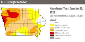
“So you’re not getting a lot of water out of that snowpack, number one,” Glisan says, “but if the drier soils are frozen deeper, it’s going to take a while for those profiles to thaw late winter/early spring, so even if you’re melting that snowpack, a lot of that’s not infiltrating, it’s running off.”
Much of Iowa, Nebraska and South Dakota has been in a significant drought for most of the last two years.
Today: Mostly cloudy this morning; P/Cloudy this afternoon. High 31. NW @ 10-20 mph.
Tonight: Fair to P/Cldy. Low 15.
Tomorrow: Partly cloudy. High 38. SE @ 10 mph.
Saturday: Mo. Cldy w/light snow or flurries. High 32.
Sunday: P/Cldy. High 35.
Wednesday’s High in Atlantic was 29. Our Low this morning was 25. We received .3” of snow from 7am Wed. thru 5:30-a.m. today. Last year on this date the High in Atlantic was 14 and the Low was -3. The Record High on this date was 62 in 2012. The Record Low was -26 in 2010.


