
(Radio Iowa) – A survey team from the National Weather Service is looking over the damage from a tornado that touched down in south-central Iowa last (Tuesday) night near Knoxville and Pleasantville. Meteorologist Donna Dubberke, at the Weather Service office in metro Des Moines, says there were multiple reports of funnel clouds and tornadoes in Marion and Warren counties, but it appears it was a single twister that reached the ground. “At this point, we think it’s just one,” Dubberke says. “Once we get out, today is a lot about piecing all those puzzle pieces together to see exactly how it developed and from the video and what we’ve seen, it looks like it was one.”
There are dozens of reports of hail during last night’s storm from locations scattered across a wide section of Iowa, damaging the siding and roofs of houses, smashing windows and ruining vehicles. “Pretty much diagonally, from the southwest corner of the state up to the northeast, there were hail reports,” Dubberke says. “Some of the larger hail reports were up to three inches in diameter which is very large, so baseball size and larger. The Osceola area had quite a bit, Davenport had some reports of that as well.” The Quad Cities reported peak wind gusts of 90 miles an hour, straight-line winds which broke off tree limbs and caused power outages. Despite the wreckage, last night’s storms were not as severe as last Friday’s barrage.

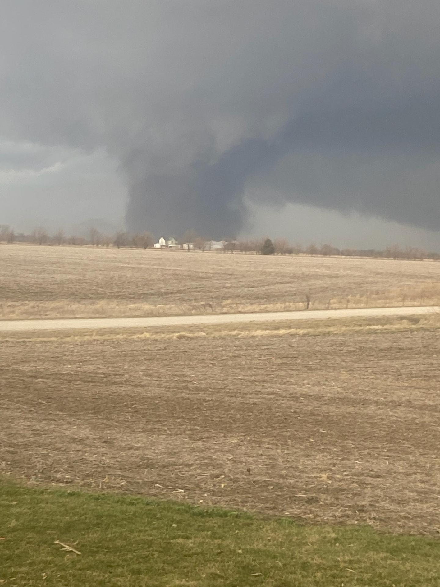
Funnel cloud near Melcher Dallas. Photo by Tim Johnson, submitted to the National Weather Service.
“With widespread areas certainly, for the hail and a lot of several rounds of storms,” she says, “so it was longer-lasting in some ways but did not have quite the intensity that the one on Friday had.” That previous storm spun off at least 16 tornadoes and left 18 Iowa counties declared disaster areas, with at least nine people injured. Dubberke says the storms should be gone for a while now and calmer, springtime weather is ahead. “The rest of this week and into the weekend, it looks nice, a warming trend,” Dubberke says. “Today, it’ll be the coldest day, then warming a little bit each day, and tomorrow and Friday, we should have some nice sunshine. Next chance of rain is on Sunday and as of right now, it doesn’t look all that impactful.”
Temperatures through the weekend are forecast to warm into the 60s and 70s, with 80s likely next week.
(Des Moines, Iowa) – The National Weather Service, in it’s report on storms that occurred Tuesday, April 4, 2023, said that in southwest Iowa, there were a few relayed reports of hail, but no tornadoes. Here are some of the storm spotter/law enforcement reports:
One-half inch diameter hail 5 miles N/NE of Afton (Union County)
Nickel-size hail fell in Orient (Adair County)
1.75-inch hail fell in Bedford (Taylor County)
1.75-inch hail 4-miles E. of New Market (Taylor Co.)
1 .5 diameter hail 2 mile E. of New Market
One-half inch diameter hail in Mount Ayr (Ringgold County)
One-inch hail was reported 3 miles W/NW of Orient (Adair County)
1.75 inch diameter hail in St. Charles (Madison County)
One-inch diameter hail was reported 3 miles south/southwest of Bedford (Taylor County), and Nickel-size hail was reported to have fallen in Nodaway (Adams County)
Nickel-size hail was reported 3-miles east of Orient, in Adair County
Golf ball size hail fell in Orient
Today: Partly sunny, with a high near 45. Windy, with a west northwest wind around 23 mph, with gusts as high as 30 mph.
Tonight: Mostly clear, with a low around 23. Blustery, with a west northwest wind 7 to 17 mph, with gusts as high as 23 mph.
Thursday: Sunny, with a high near 56. West southwest wind 7 to 11 mph.
Friday: Sunny, with a high near 65.
Saturday: Sunny, with a high near 69. Windy.
Tuesday’s High in Atlantic was 81. The Low was 31. Last year on this date the High in Atlantic was 59 and the Low was 38. The Record High on this date was 88 in 2000. The Record Low was 14 in 1920.
(Radio Iowa) – State climatologist Justin Glisan says snow in March made for a split in temperatures in the state. “We had across the state if you look at temperatures, near normal conditions in eastern Iowa, and then slightly cooler conditions as we move northwest where we had more snowpack,” Glisan says, “so the statewide average temperature came in right about 34 degrees, and that’s about two and a half degrees below average.”There wasn’t enough snowfall though to help March hit its average for precipitation. “About one and a half inches of snow liquid equivalent and then rainfall and that’s about a half inch below average,” he says.
Glisan says the long-term outlook as we start April shows the potential for more rain.”For the month of April, we’re looking at an elevated signal for wetter conditions across basically much of the eastern three quarters of the state — equal chances along the western border. Temperature wise, no clear guidance there,” he says. “Slightly elevated for cooler conditions across northern Iowa and then E-C (equal chances) for the rest of the state.”
Glisan says there’s a short-term indication of drier conditions in April — which would help farmers itching to get into the fields.
(Atlantic, Iowa/KJAN) – The month of March in Atlantic came to a close with weather stats averaging lower than normal. High average High for the month in Atlantic (as recorded here at KJAN), was 47.8-degrees, which was cooler the norm of 48.3. The average Low for March 2023 in Atlantic was 22.6-degrees, which came in a little less than 4-degrees below normal. The warmest day of the month was on the 31st, at 75-degrees. The coldest morning was on the 18th, when the thermometer bottomed-out at 8-degrees.
And, precipitation for the month amounted to 1.01-inches (including rain, melted snow and mixed precip.), compared to the norm of 2.38-inches. We received a total of 6-inches of snow, with the greatest amounts occurring March 8th & 9th.
Today: **RED FLAG WARNING from Noon until 8-p.m.** A chance of showers, with thunderstorms also possible after 5pm. Some of the storms could be severe. Cloudy, then gradually becoming mostly sunny, with a high near 81. Windy, with an east northeast wind 14 to 23 mph becoming south in the afternoon. Winds could gust as high as 32 mph. Chance of precipitation is 30%. New rainfall amounts of less than a tenth of an inch, except higher amounts possible in thunderstorms.
Tonight: A 40 percent chance of showers and thunderstorms, mainly before 11pm. Some of the storms could be severe. Partly cloudy, with a low around 31. Windy, with a south southwest wind 16 to 22 mph becoming west northwest after midnight. Winds could gust as high as 33 mph. New rainfall amounts of less than a tenth of an inch, except higher amounts possible in thunderstorms.
Wednesday: Mostly sunny, with a high near 44. Windy, with a west northwest wind 21 to 25 mph, with gusts as high as 34 mph.
Thursday: Sunny, with a high near 56. West wind 9 to 13 mph, with gusts as high as 20 mph.
Friday: Sunny, with a high near 66. Breezy.
(Radio Iowa) – Preliminary reports from the National Weather Service office in the Quad Cities shows at least 16 tornadoes touched down in eastern Iowa Friday. Lead Meteorologist, Justin Schultz, says that number could still go up as they continue looking at damage. “The vast majority of the tornadoes that we surveyed were of the E-F-zero to E-F-two range. So that’s the bottom portion of the Enhanced Fujita tornado strength scale,” he says. The strongest tornado
traveled through Keokuk and Washington counties.
“That was rated as an EF-four. The E-F-four is not as the highest on the Enhanced Fujita scale goes, that goes up to five,” Schultz says, “but still a very powerful and very violent tornado, that particular one.” He says that tornado started on a smaller scale in Wappello County before traveling into Keokuk County. “When it was in Wappello County down by Ottumwa — it was an E-F 2 at that time,” he says..
The E-F-four tornado had a width of 600 yards by the time it hit its peak, and did lots of damage. “There were several severely damaged homes near that Keota, Iowa, in fact, wiping one house completely off its foundation,” Schultz says. “So, in addition, a car was lost in the air and toss about one thousand feet into a nearby field and trees were completely debarked and only stubs are the largest branches for remaining. So that kind of gives you a glimpse at the damage that we saw.”
The N-W-S says there were nine people confirmed injured in the tornadoes — and no one was killed. Schultz says that’s because many of the twisters had a short life. “A lot of these tornadoes were actually fairly short lived, only on the ground for a few minutes or maybe up to 10. But that E-F-four, that was actually on the ground for close to 50 minutes. So that was a very long-track, long-lived tornado,” he says. That tornado had estimated peak winds of 170 miles an hour. Schultz says many of these tornadoes appeared darker as they pulled up dry ground and debris into them as they moved along.
(Radio Iowa) – Governor Kim Reynolds issued disaster proclamations for 12 counties this weekend after several tornados touched down Friday.. The governor’s proclamation allows state resources to be used to respond in Cedar, Clinton, Delaware, Des Moines, Dubuque, Grundy, Johnson, Keokuk, Linn, Mahaska, Wapello, and Washington counties. Delaware County Emergency Management Coordinator Mandy Bieber says the storms spread across the county — with significant damage in the Manchester area and also in Greeley and Oneida.
The National Weather Service is out assessing the damage and has confirmed there was an E-F-2 tornado in Wapello County northeast of Ottumwa. At least three homes and one hog confinement facility were damaged. Other assessment continues.
Today: A 20 percent chance of showers between 1pm and 2pm. Increasing clouds, with a high near 57. East northeast wind 7 to 15 mph, with gusts as high as 23 mph.
Tonight: Mostly cloudy, with a low around 43. Windy, with an east northeast wind 15 to 22 mph, with gusts as high as 44 mph.
Tomorrow: A slight chance of showers, with thunderstorms also possible after 4pm. Mostly cloudy, then gradually becoming sunny, with a high near 77. Windy, with an east wind 14 to 21 mph becoming south in the afternoon. Winds could gust as high as 31 mph. Chance of precipitation is 20%.
Wednesday: Mostly sunny, with a high near 44. Windy.
Thursday: Sunny, with a high near 53.
Sunday’s High in Atlantic was 73. The Low was 34. Last year on this date the High in Atlantic was 52 and the Low was 28. The Record High on this date was 85 in 1981. The Record Low was 4 in 1975.
(Des Moines, Iowa) – The National Weather Service in Des Moines, in it’s latest report on an intense storm system that tracked across the state of Iowa on Friday, March 31st, says the system pulled unseasonably warm and moist conditions into the Midwest, which coupled with a very favorable wind profile, and created quite the volatile environment for severe thunderstorms. This produced several long lived supercells which developed across central Iowa during the afternoon. The storms were prolific hail producers along with a few reports of wind damage as they moved rapidly northeast. Eventually, the storms produced a few tornadoes before exiting into eastern Iowa.
One of the documented tornadoes began in Wapello County northeast of Ottumwa then tracked northeast into Keokuk County. The primary damage in Wapello County consisted of three homes and one hog confinement facility. The first home lost the entire roof and one external wall. The first failure point was likely the wind entering and lifting the garage which then led to failure of the roof. The home only had straight nailed connections to the external walls spaced
every 18 inches and less to the roof.
Tornado in northeast Wapello County.
Photo credit: Wapello Sheriff / EM
An unoccupied mobile home on the property was not well anchored and rolled to total destruction. This location was rated 110 mph and EF-1. Two well anchored hog confinement buildings were totally destroyed and were rated EF-2. The tornado then impacted a location with a well built 2 story brick house. The house suffered some roof and window damage
and a loss of a garage door but sustained little other damage. Other damage indicators at the site suggested
EF-1 winds.
Total destruction of a house occurred just prior to the tornado exiting the county. This older house sat unanchored to the concrete block basement. The house was pushed off the foundation and crumbled. Some trees near the house and a propane tank were mostly left with little damage. A larger tree directly next to the house on the wind side had several large limbs removed. Due to all of these reasons, the wind at this location has been rated at 135 mph, or high end EF-2.
The Tornado Path extends into Keokuk County. The National Weather Service in the Quad Cities reports “After collaboration with a team of survey experts, we have determined a prelim. rating of low end EF4 for the tornado that tracked from Wapello into Johnson County IA. Max estimated winds around 170 mph. Max width around 600 yards. There were at least three tornadoes reported by the QC NWS office.
Today: Mostly cloudy, then gradually becoming sunny, with a high near 69. Windy, with a south wind 11 to 21 mph becoming west in the afternoon. Winds could gust as high as 30 mph.
Tonight: Partly cloudy, with a low around 38. North northwest wind 8 to 10 mph becoming east northeast after midnight.
Monday: A 30 percent chance of rain, mainly before 1pm. Partly sunny, with a high near 56. Breezy, with an east northeast wind 10 to 16 mph, with gusts as high as 20 mph.
Monday Night: A 20 percent chance of rain after 1am. Mostly cloudy, with a low around 42. Windy, with an east northeast wind 16 to 24 mph, with gusts as high as 37 mph.
Tuesday: A chance of rain, with thunderstorms also possible after 10am. Partly sunny, with a high near 76. Windy, with an east wind 15 to 21 mph becoming south in the afternoon. Winds could gust as high as 31 mph. Chance of precipitation is 40%. New rainfall amounts of less than a tenth of an inch, except higher amounts possible in thunderstorms.
Tuesday Night: A chance of rain and thunderstorms. Partly cloudy, with a low around 29. Windy. Chance of precipitation is 30%. New precipitation amounts of less than a tenth of an inch, except higher amounts possible in thunderstorms.
Wednesday: Partly sunny, with a high near 42. Windy.
Saturday’s High in Atlantic was 54. The Low was 29. Last year on this date the High in Atlantic was 60 and the Low was 26. The Record High on this date was 88 in 2012. The Record Low was 13 in 1970.


