
(Radio Iowa) – Iowans may be anxious to clear the dry brush from their properties and get on with spring, but they’re warned not to set any fires. Outdoor burning is not recommended, and a dozen counties in northwest Iowa are under a Red Flag Warning until nine o’clock tonight. The warning means weather conditions are ideal for small brushfires to quickly get out of hand and spread and residents statewide are urged to heed the advisory.
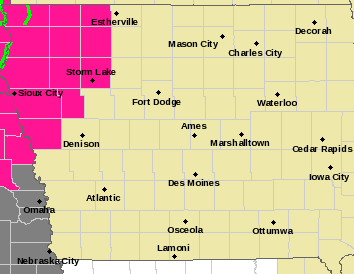
Red Flag Warning for counties in pink https://www.weather.gov/dmx/
Forecasters say high temperatures today will climb into the 70s and 80s, while the humidity level is low, the winds are high with gusts up to 40 miles an hour, and the vegetation is very dry.
Today: Sunny, with a high near 82. Breezy, with a south southwest wind 6 to 11 mph increasing to 13 to 18 mph in the afternoon. Winds could gust as high as 23 mph.
Tonight: Mostly clear, with a low around 55. Breezy, with a south southwest wind 14 to 18 mph, with gusts as high as 33 mph.
Wednesday: Sunny, with a high near 86. Windy, with a south southwest wind 18 to 22 mph, with gusts as high as 37 mph.
Thursday: Sunny, with a high near 80. Windy.
Friday: A slight chance of showers, then a chance of showers and thunderstorms after 1pm. Partly sunny, with a high near 77. Windy. Chance of precipitation is 30%.
Monday’s High in Atlantic was 75. The Low was 40. Last year on this date the High in Atlantic was 64 and the Low was 32. The Record High on this date was 91 in 1996. The Record Low was 18 in 1956 & 2004.
(Radio Iowa) – The D-N-R expert who keeps tabs of waterflow levels in the state says March was dry, but overall we are heading into spring in good shape. Tim Hall says snow and rain have help cut down some dry areas. “It sets us in a much better position than we thought we might be coming out of last fall. Typically, we don’t see a lot of moisture in the wintertime, but we had a lot of moisture in December, January, February,” he says. “We were a little bit short for March, but it doesn’t put us in too bad of shape going into the growing season.”
Iowa’s new Drought Plan lists the state in a “Drought Watch,” which Hall says is a signal to keep a close eye on what’s happening. “And what that really means is could have a wet April and the watch could go away and we could go back to normal,” Hall says. “We can have a dry April, and then we’d have to look at what would happen to those conditions. So it kind of puts us on the edge.” He says there are still some dry areas in the state, but things are much better thanks to those wetter months. “And what we have to watch carefully is the supply side of water. And hopefully, if we get normal to just slightly above normal rainfall in April, I think we’ll be okay,” he says. But if March was the start of a string of dry months, then we could be in a more challenging situation.”
Hall says the improvement is not a signal we have enough water not to worry about it. “There’s a difference between being smart about how we use water and sort of these extreme conservation measures. And as we’re into normal conditions across much of the state –that’s not a that’s not a call to start wasting water,” Hall says. “Be careful with what you do. And, and, you know, certainly people like their green lawns, but let’s just not get carried away. Fix your faucets that leak, fix your toilets that leak, you know, those are just generally responsible things to do with water.”
He says we should try to not waster water whether we are in a drought situation, or have normal levels.
(Radio Iowa) – Iowans have seen several unseasonable snowstorms this spring, but none of them compare to what’s known as the Blizzard of ’73. It was 50 years ago on Sunday that a monster winter weather system blasted into Iowa. The storm hit on a Monday, April 9th, 1973. Meteorologist Craig Cogil, at the National Weather Service, says the powerful winds whipped up massive drifts that were so deep, they completely covered houses. “Quite a massive storm that moved across the state, burying many locations across Iowa with a foot or more of snowfall,” Cogil says. “A few locations had the most snow ever, including Dubuque that had almost 20 inches of snow at 19.2.”
School was cancelled for several days in districts practically statewide. Many stores were closed and traffic was at a standstill due to the high drifts. State highways were littered with hundreds of stranded cars. “Around the Des Moines area, a foot of snow was pretty common and heading down to the southwest,” Cogil says. “There were even some drifts that got up to 15 feet, so for April, just an outstanding snowstorm for that time of year.” Cogil says the snow persisted for several days, but disappeared by the end of the week.
“It warms up this time of year pretty quickly, so the snow didn’t stick around too much, but unfortunately, when it was here, it sure caused a mess, shutting down a lot of highways,” Cogil says. “We had reports of at least seven people dying from heart attacks primarily from scooping the snow.” The Friday before the storm, temperatures were in the 70s, as golfers took advantage of the courses in the Des Moines area. The day of the storm, the high only made it to 29. Two weeks after the storm, temperatures returned to the 70s.
Today: Light rain/showers ending; Partly cloudy. High 74. SE @ 10.
Tonight: Mostly clear. Low 50. S @ 5.
Tomorrow: P/Cldy & windy. High 79. SW @ 10-20.
Wednesday: Sunny & windy. High 83.
Thursday: Sunny & windy. High 79.
Sunday’s High in Atlantic was 75. The Low was 46. We received .18″ of rain early this morning. Last year on this date the High in Atlantic was 73 and the Low was 30. The Record High on this date was 94 in 1930. The Record Low was 17 in 1989.
Today: Partly sunny, with a high near 71. Breezy, with a south wind 10 to 16 mph, with gusts as high as 22 mph.
Tonight: A 30 percent chance of showers, mainly after 4am. Mostly cloudy, with a low around 48. South wind 6 to 10 mph.
Monday: A 20 percent chance of showers between 8am and 9am. Mostly sunny, with a high near 72. South southeast wind around 7 mph.
Monday Night: Mostly clear, with a low around 48. South wind 7 to 10 mph.
Tuesday: Sunny, with a high near 79. Breezy, with a south southwest wind 10 to 20 mph, with gusts as high as 24 mph.
Tuesday Night: Clear, with a low around 56. Windy.
Wednesday: Sunny, with a high near 82. Windy.
Saturday’s High in Atlantic was 71. The Low was 22. Last year on this date the High in Atlantic was 61 and the Low was 19. The Record High on this date was 85 in 1977. The Record Low was 14 in 2016.
Skyscan Forecast Saturday, April 8, 2023 Austin Romer
Today: Mostly sunny. S @ 20. High 69.
Tonight: Mostly cloudy. S @ 15. Low 45.
Easter Sunday: Cloudy. Slight chance of showers. S @ 20. H 68.
Sunday Night: Mostly cloudy. Chance of showers and thunderstorms. S @ 5-10. Low 49.
Monday: Mostly sunny. S @ 10. High 69.
Tuesday: Mostly sunny. S @ 15. High 77.
Yesterday’s high was 69 and the low was 22. This day last year the high was 52 and the low was 18. The all-time record high was 89 set in 1931 and the record low was 14 in 2016. Sunrise this morning is 6:53 a.m. and sunset tonight is 7:52 p.m.
Today: Sunny, with a high near 66. Breezy, with a south southwest wind 7 to 16 mph, with gusts as high as 21 mph.
Tonight: Clear, with a low around 38. Breezy, with a south wind 13 to 16 mph, with gusts as high as 24 mph.
Saturday: Sunny, with a high near 68. Breezy, with a south wind 14 to 18 mph, with gusts as high as 24 mph.
Saturday Night: Partly cloudy, with a low around 42. South southeast wind around 14 mph, with gusts as high as 23 mph.
Sunday: Partly sunny, with a high near 69. Breezy.
Sunday Night: A 20 percent chance of showers. Mostly cloudy, with a low around 48.
Monday: Mostly sunny, with a high near 71.
Thursday’s High in Atlantic was 57. The Low was 13. Last year on this date the High in Atlantic was 43 and the Low was 31. The Record High on this date was 85 in 2000. The Record Low was 10 in 2018.
Today: Sunny, with a high near 56. West southwest wind 6 to 10 mph.
Tonight: Mostly clear, with a low around 32. South wind 8 to 14 mph, with gusts as high as 22 mph.
Friday: Sunny, with a high near 65. Breezy, with a south southwest wind 8 to 17 mph, with gusts as high as 20 mph.
Friday Night: Clear, with a low around 40. South wind 13 to 15 mph, with gusts as high as 22 mph.
Saturday: Sunny, with a high near 69. Breezy, with a south wind 13 to 17 mph, with gusts as high as 22 mph.
Saturday Night: Partly cloudy, with a low around 46. Breezy.
Sunday: Partly sunny, with a high near 73. Breezy.
Wednesday’s High in Atlantic was 46. The Low was 13. Last year on this date the High in Atlantic was 51 and the Low was 37. The Record High on this date was 89 in 1972. The Record Low was 6 in 1982.


