1006 AM CST TUE FEB 26 2013
…WINTER WEATHER ADVISORY IN EFFECT UNTIL NOON CST WEDNESDAY…
THE NATIONAL WEATHER SERVICE IN DES MOINES HAS ISSUED A WINTER WEATHER ADVISORY FOR SNOW AND BLOWING SNOW WHICH IS IN EFFECT UNTIL NOON CST WEDNESDAY.
* TIMING OR SHORT TERM TRENDS...SNOW WILL CONTINUE TO MOVE INTO THE AREA LATE THIS MORNING. ONCE THE SNOW STARTS…LIGHT TO MODERATE SNOW WILL CONTINUE THROUGH WEDNESDAY MORNING.
* STORM TOTAL SNOW/ICE ACCUMULATIONS…TOTAL SNOW ACCUMULATIONS WILL FROM 2 TO 5 INCHES. THERE WILL BE A SHARP NORTHWEST EDGE TO THE SNOW.
* WINDS/VISIBILITY...NORTH WINDS AT 15 TO 30 MPH WILL CAUSE BLOWING AND DRIFTING SNOW.
* IMPACTS…TRAVEL WILL BE SIGNIFICANTLY IMPACTED BY THE SNOW AND BLOWING SNOW.
PRECAUTIONARY/PREPAREDNESS ACTIONS… A WINTER WEATHER ADVISORY FOR SNOW AND BLOWING SNOW MEANS THAT VISIBILITY WILL BE LIMITED DUE TO A COMBINATION OF FALLING AND BLOWING SNOW. USE CAUTION WHEN TRAVELING…ESPECIALLY IN OPEN AREAS.
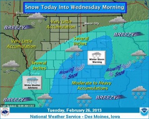
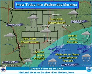
A storm system over east central Missouri will lift into the Ohio Valley and produce snow over much of Iowa through Wednesday morning. Moderate to heavy snowfall will occur over the southeast half of Iowa and parts of Missouri and Illinois. Strong north winds will cause blowing snow and reduced visibility in these areas, making travel hazardous. Winter storm warnings are posted for a large part of the southeast half of Iowa with winter weather advisories from southwest into parts of north central and northeast Iowa. The snow will end on Wednesday, with cool and dry weather expected for the remainder of the week.
NATIONAL WEATHER SERVICE DES MOINES IA
846 AM CST TUE FEB 26 2013

...SNOW AND BLOWING SNOW TO AFFECT PORTIONS OF CENTRAL IOWA TODAY
AND TONIGHT...

.LOW PRESSURE WILL MOVE THROUGH ILLINOIS TODAY BRINGING SNOW TO
PORTIONS OF CENTRAL IOWA TODAY INTO TONIGHT. INCREASING NORTH
WINDS WILL CAUSE SIGNIFICANT BLOWING AND DRIFTING SNOW ACROSS THE
AREA THROUGH THE DAY...WITH TRAVEL CONDITIONS BECOMING DIFFICULT
IN MUCH OF THE HEADLINE AREA.

IAZ038-039-048>050-059>061-071>073-081-082-092-262300-
/O.EXA.KDMX.WW.Y.0003.000000T0000Z-130227T1200Z/
GRUNDY-BLACK HAWK-STORY-MARSHALL-TAMA-DALLAS-POLK-JASPER-ADAIR-
MADISON-WARREN-ADAMS-UNION-TAYLOR-
INCLUDING THE CITIES OF...GRUNDY CENTER...WATERLOO...AMES...
MARSHALLTOWN...TOLEDO...ADEL...DES MOINES...NEWTON...GREENFIELD...
WINTERSET...INDIANOLA...CORNING...CRESTON...BEDFORD
846 AM CST TUE FEB 26 2013

...WINTER WEATHER ADVISORY IN EFFECT UNTIL 6 AM CST WEDNESDAY...

THE NATIONAL WEATHER SERVICE IN DES MOINES HAS ISSUED A WINTER
WEATHER ADVISORY FOR SNOW AND BLOWING SNOW...WHICH IS IN EFFECT
UNTIL 6 AM CST WEDNESDAY.

* SHORT TERM TRENDS...SNOW WILL CONTINUE ACROSS THE ADVISORY AREA
  THROUGH THE MORNING AND INTO THE AFTERNOON. THE SNOW WILL BE
  HEAVY AT TIMES WITH SNOWFALL RATES OF UP TO AN INCH PER HOUR.

* STORM TOTAL SNOW ACCUMULATIONS...SNOWFALL ACCUMULATIONS OF 3 TO
  6 INCHES ARE EXPECTED WITH THE HEAVIEST AMOUNTS ON THE SOUTHEAST
  SIDE OF THE ADVISORY.

* WINDS/VISIBILITY...NORTH TO NORTHEAST WINDS OF 15 TO 30 MPH WITH
  HIGHER GUSTS ARE EXPECTED TO CAUSE BLOWING AND DRIFTING OF SNOW
  AND REDUCE VISIBILITY UNDER ONE QUARTER MILE AT TIMES THROUGHOUT
  MUCH OF TODAY.

* IMPACTS...TRAVEL CONDITIONS WILL DETERIORATE QUICKLY AS THE SNOW
  CONTINUES THROUGH THE MORNING HOURS.

PRECAUTIONARY/PREPAREDNESS ACTIONS...

A WINTER WEATHER ADVISORY FOR SNOW AND BLOWING SNOW MEANS THAT
VISIBILITY WILL BE LIMITED DUE TO A COMBINATION OF FALLING AND
BLOWING SNOW. USE CAUTION WHEN TRAVELING...ESPECIALLY IN OPEN
AREAS.
(National Weather Service/Dsm) — A storm system moving across the Southern Plains and lifting into the Ohio Valley will produce snow over Southeast Iowa today through Wednesday morning. Moderate to heavy snowfall is still expected across far Southeastern Iowa and parts of Missouri and Illinois. Strong north winds will cause blowing snow and reduced visibility in these areas, making travel hazardous. Winter storm warnings are posted for parts of Southeast Iowa with winter weather advisories for parts of South central to East central Iowa. The snow will end on Wednesday, with cool and dry weather expected for the remainder of the week.
From Freese-Notis Meteorologist Harvey Freese, and the weather data for Atlantic….
Podcast: Play in new window | Download (1.0MB)
Subscribe: RSS
TODAY…CLOUDY…BREEZY. A CHANCE OF SNOW THROUGH MID MORNING…THEN SNOW LIKELY BEFORE NOON. A CHANCE OF SNOW IN THE AFTERNOON. SNOW ACCUMULATION UP TO 2 INCHES. HIGH IN THE LOWER 30S. NORTH WIND15 TO 20 MPH WITH GUSTS TO AROUND 30 MPH. CHANCE OF SNOW 60 PERCENT.
TONIGHT…CLOUDY WITH A 40 PERCENT CHANCE OF SNOW. BREEZY. LOW IN THE MID 20S. NORTH WIND 15 TO 20 MPH.
WEDNESDAY…CLOUDY…BREEZY. HIGH IN THE MID 30S. NORTH WIND 15 TO 20 MPH WITH GUSTS TO AROUND 30 MPH.
WEDNESDAY NIGHT…PARTLY CLOUDY. LOW IN THE LOWER 20S. NORTHWEST WIND 10 TO 15 MPH WITH GUSTS TO AROUND 25 MPH.
THURSDAY…PARTLY SUNNY. HIGH IN THE MID 30S. NORTHWEST WIND 10 TO 15 MPH.
THURSDAY NIGHT AND FRIDAY…MOSTLY CLOUDY. LOW IN THE LOWER 20S. HIGH IN THE LOWER 30S.
Forecasters say another winter storm is headed for Iowa that has the potential to drop significant snow on parts of the state. Meteorologist Roger Vachalek, at the National Weather Service, says this system should drop the deepest snow on a different area of Iowa from last week’s storm. He says the system will arrive late tonight and early tomorrow and it should bring snow to the southeastern half of the state. The heaviest totals are expected in the southeast. Cities like Ottumwa, Fairfield, Burlington and Keokuk could see between five and nine inches of snow. Parts of central Iowa may only see two to four inches, with little-to-no snow expected in the northwest. Vachalek says there’s another issue with this approaching storm.
Some strong winds may accompany the storm, with gusts around 15 to 25 miles an hour, so blowing snow could become a visibility problem for motorists. The National Weather Service has issued a Winter Storm Watch for parts of southeast and south-central Iowa from late tonight into Tuesday. Cities in the advisory include: Lamoni, Ottumwa, Iowa City and Davenport. In far southeast Iowa, Lee and Des Moines counties are under a Winter Storm Warning from 3 tomorrow morning until midnight tomorrow night. Late last week, another snowstorm coated much of Iowa in white, dumping the most snow in the Sioux City area, which reported ten inches.
(Radio Iowa)
Whether the drought continues or not, Iowa farmers will soon be able to check soil moisture levels at a dozen key spots statewide.
Elwynn Taylor, an agronomist at the Iowa State University Extension, says moisture levels can vary greatly over short distances, but this new network will offer farmers good ballpark figures. “People that have a sandy place and a place with clay already know they have great differences,” Taylor says, “but still, if we have some idea on a very common soil for the county, if we know what is going on there, it will give an idea of how things are changing and the likely direction it will be moving in.”
I-S-U’s Department of Agronomy is upgrading weather stations at several research and demonstration farms. At least 12 should be fully functional in several weeks when spring arrives. Farmers can always dig a hole themselves to try and gauge the soil moisture, but Taylor says doing so accurately is a hassle. “To really know, you have to get a measure of soil from a certain depth, weigh it, dry it, weigh it again and see how much water the drying removed from it to know how much water was really there in your soil,” Taylor says. “It gets to be a real headache and, of course, people aren’t going to do that on a day by day, week by week, month by month basis.”
At each station, moisture sensors will be placed a foot, two feet and four feet deep in the soil. Readings will be taken every 15 minutes and sent by cellular phone text messages to the network. Each station costs about 12-thousand dollars to buy and install. It’s hoped the network of weather stations can be expanded so there’s one in every county, but for now, a dozen will give a good snapshot of drought conditions to help farmers manage their risks. “If you see that the weather station received an inch of rain and the soil moisture has moved up to such and such a level from where it was at the moisture station, and you know that at your farm because of the gauge out on your post that you got an inch and a quarter, you probably did a little better,” Taylor says, “or if you got half an inch, you didn’t do as well.”
The new weather stations replace ones that have been monitoring data at the farms for more than 30 years. Taylor said the original units made up the world’s first non-military network of automatic reporting weather stations. The weather stations will also measure rainfall, air and soil temperature, humidity, sunlight, wind speed and direction. A solar collector powers the units.
(Radio Iowa)
The Freese-Notis forecast for Atlantic & the KJAN listening area, and weather data for Atlantic…
Podcast: Play in new window | Download (1.2MB)
Subscribe: RSS
A storm will arrive Tuesday morning in southern Iowa and lift northeast during the day.
Moderate to heavy snowfall is still expected across the southeast half of the state with the heavier totals in the southeast and over Missouri. High pressure over the northern Plains may reduce some of the storms snowfall over the region and a slight shift in the track may also cause some adjustment in snowfall amounts. Even with those uncertainties strong north winds will cause blowing snow and reduced visibility over the southeast and portions of central Iowa. Interested persons are urged to check the latest forecasts today and tonight.