(Updated 4:16-a.m./NWS Des Moines)
Today: Rain likely, mainly after 3pm. Cloudy, with a high near 38. East southeast wind 6 to 13 mph becoming north in the afternoon. Chance of precipitation is 60%. New precipitation amounts of less than a tenth of an inch possible.
Tonight: Snow and freezing drizzle likely, becoming all snow after 9pm, then gradually ending. Cloudy, with a low around 26. Blustery, with a northwest wind 6 to 11 mph increasing to 15 to 20 mph after midnight. Winds could gust as high as 28 mph. Chance of precipitation is 60%. Little or no ice accumulation expected. New snow accumulation of less than a half inch possible.
Tuesday: A 20 percent chance of snow after noon. Cloudy, with a high near 30. Windy, with a northwest wind 18 to 24 mph, with gusts as high as 32 mph.
Tuesday Night: Partly cloudy, with a low around 15. Wind chill values as low as 5. Blustery, with a north northwest wind 15 to 20 mph decreasing to 8 to 13 mph after midnight. Winds could gust as high as 28 mph.
Wednesday: Sunny, with a high near 36. North northwest wind 5 to 8 mph becoming east southeast in the afternoon.
Wednesday Night: Mostly clear, with a low around 18.
Thursday: Mostly sunny, with a high near 40. Breezy.
SAC-CRAWFORD-CARROLL-GREENE-AUDUBON-GUTHRIE-DALLAS-POLK-CASS-
ADAIR-MADISON-ADAMS-AND UNION COUNTIES
318 PM CST SUN MAR 3 2013
…WINTER WEATHER ADVISORY IN EFFECT FROM MIDNIGHT TONIGHT TO NOON CST MONDAY…
THE NATIONAL WEATHER SERVICE IN DES MOINES HAS ISSUED A WINTER WEATHER ADVISORY FOR SNOW AND ICE…WHICH IS IN EFFECT FROM MIDNIGHT TONIGHT TO NOON CST MONDAY.
* TIMING...LIGHT SNOW AND LIGHT FREEZING RAIN IS FORECAST TO DEVELOP AFTER 8 PM AND CONTINUE OVERNIGHT. THIS BAND WILL MOVE INTO WISCONSIN AND MINNESOTA BY MID MONDAY MORNING. LOOK FOR PERIODS OF LIGHT FREEZING DRIZZLE MONDAY MORNING BEFORE ANOTHER PERIOD OF MODERATE SNOW OCCURS MONDAY NIGHT THROUGH TUESDAY.
* STORM TOTAL SNOW/ICE ACCUMULATIONS…ACCUMULATIONS OF 1 TO 3 INCHES WITH LOCALLY HIGHER AMOUNTS POSSIBLE EAST. ON THE SOUTHERN EDGE OF THE SNOW SHIELD THERE WILL BE PERIODS OF LIGHT FREEZING RAIN AND SNOW LATE TONIGHT AND EARLY MONDAY. A LIGHT GLAZING UP TO ONE TENTH OF AN INCH OF ICE IS EXPECTED TO OCCUR.
* WINDS/VISIBILITY…SOUTHEAST WINDS AT 15 TO 20 MPH WITH GUSTS NEAR 25 MPH ARE EXPECTED TONIGHT INTO MONDAY MORNING. WINDS WILL DIMINISH DURING THE AFTERNOON MONDAY AND MONDAY NIGHT… THEN SHIFT AND INCREASE FROM THE NORTH TO NORTHWEST BY TUESDAY. PERIODS OF REDUCED VISIBILITY TO LESS THAN A HALF MILE AT TIMES CAN BE EXPECTED LATE TONIGHT INTO MONDAY MORNING…AND AGAIN THROUGHOUT THE DAY TUESDAY.
* IMPACTS…SNOW ACCUMULATIONS ALONG WITH GUSTY WINDS AND LIGHT ICE ACCUMULATION ARE FORECAST. LOWERED VISIBILITY…SNOW OR ICE COVERED ROADS… AND HAZARDOUS DRIVING CONDITIONS ARE EXPECTED.
PRECAUTIONARY/PREPAREDNESS ACTIONS…
A WINTER WEATHER ADVISORY MEANS THAT PERIODS OF SNOW…SLEET…OR FREEZING RAIN WILL CAUSE TRAVEL DIFFICULTIES. BE PREPARED FOR SLIPPERY ROADS AND LIMITED VISIBILITY…AND USE CAUTION WHILE DRIVING.
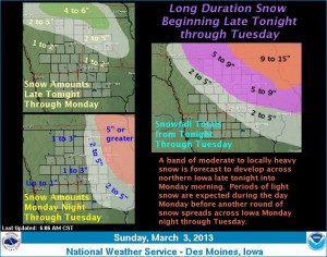
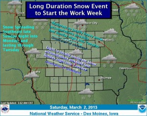
Southwest and western Iowa look to have dodged a bullet where the latest snow storm is concerned. The National Weather Services says \aA band of moderate to locally heavy snow is forecast to develop late tonight and continue into Monday morning across northern Iowa before moving northeast into Wisconsin and Minnesota. Periods of light snow are expected from late Monday morning through the afternoon before another round of moderate snow develops Monday evening and continues into Tuesday. North central to northeast Iowa looks to receive the higher snowfall amounts through Tuesday.
A brief period of sleet is possible tonight across southwest Iowa, but little ice accumulation is anticipated. Dry conditions and warmer temperatures are forecast by the late work week.
412 AM CST SUN MAR 3 2013
TODAY…CLOUDY. HIGH IN THE MID 30S. SOUTHEAST WIND 5 TO 15 MPH.
TONIGHT…CLOUDY. A SLIGHT CHANCE OF LIGHT RAIN AND SLEET IN THE EVENING…THEN A CHANCE OF SNOW POSSIBLY MIXED WITH SLEET OVERNIGHT. LOW AROUND 30. SOUTHEAST WIND 10 TO 15 MPH WITH GUSTS TO AROUND 25 MPH. CHANCE OF PRECIPITATION 40 PERCENT.
MONDAY…CLOUDY. A CHANCE OF SNOW IN THE MORNING…THEN RAIN AND SNOW LIKELY IN THE AFTERNOON. NO SNOW ACCUMULATION. HIGH IN THE UPPER 30S. SOUTHEAST WIND 5 TO 10 MPH WITH GUSTS TO AROUND 20 MPH SHIFTING TO THE NORTHEAST IN THE AFTERNOON. CHANCE OF PRECIPITATION 60 PERCENT.
MONDAY NIGHT…CLOUDY. SNOW LIKELY THROUGH MIDNIGHT…THEN A CHANCE OF SNOW AFTER MIDNIGHT. SNOW ACCUMULATION AROUND 1 INCH. LOW IN THE MID 20S. NORTHWEST WIND 5 TO 15 MPH. CHANCE OF SNOW 70 PERCENT.
TUESDAY…CLOUDY WITH A 40 PERCENT CHANCE OF LIGHT SNOW. BREEZY. HIGH IN THE UPPER 20S. NORTHWEST WIND 15 TO 20 MPH WITH GUSTS TO AROUND 30 MPH.
TUESDAY NIGHT…MOSTLY CLOUDY. LOW 15 TO 20.
WEDNESDAY AND WEDNESDAY NIGHT…PARTLY CLOUDY. HIGH AROUND 30. LOW 15 TO 20.
An upper level area of low pressure is forecast to push across the Northern Plains through the weekend and enter the Midwest by late Sunday night. The low will continue to track eastward throughout the day Monday and clear the area by Tuesday. Snow is forecast to develop late Sunday night in northwest Iowa and spread south and east during the day Monday. Snow is likely to continue, especially across northern Iowa Monday night into Tuesday. Moderate to locally heavy snowfall is possible across northern Iowa late Sunday night through Tuesday and lighter amounts are forecast further south. However, uncertainties still remain with the exact track of the low pressure and may lead to a significant change in the location of the heaviest snow. An upper level ridge of high pressure is expected to build into the Central U.S. by mid week and will provide a gradual warming trend beginning Thursday.
Here’s the (podcast) weather forecast for the KJAN listening area as prepared by Freese-Notis Meteorologist Wesley Rondinelli, and weather data for Atlantic from KJAN News Director Ric Hanson…
Podcast: Play in new window | Download (1.0MB)
Subscribe: RSS
February ended on a snowy note across sections of Iowa, and that helped make the month overall a little wetter than normal. State climatologist Harry Hillaker keeps track of the precipitation. “Statewide about a quarter inch more than usual, nothing really greatly out of the ordinary as far as totals go…basically about the southeast half of the state has an unusually wet February. Unfortunately parts of west-central and southwest Iowa in particular were on the dry side of normal there,” Hillaker says.
In Atlantic, the average High for Feb. 2013 was 36-degrees, which is in line with the normal High for the month. The average Low last month was 15, which was just one degree shy of the normal 16-degree average. Hillaker says temperature readings didn’t show anything that stood out. He says he doesn’t have all the numbers in yet, but things will be very close to normal. “Preliminarily I’ve got us at two-tenths of a degree above normal, that’s about as close to normal as we can get it. Pretty much it was kind of warmer the first half of the month and consistently on the cool side the second half of the month, and basically canceled each other out and very close to normal overall,” Hillaker says.
Hillaker says the snow late in February turned around what had been a lack of the white stuff for most of this winter. One storm dumped a statewide average of just over five inches of snow, while another left an average of four inches across the state. In Atlantic, we received a total of 5.6-inches of snow in February, which had a liquid precipitation value of just under one-half inch, or .46″.
Average High for the month: 36.2 degrees. Average Low: 15.3. Precipitation (including any rainfall & melted snow): .46″. Snowfall total: 5.6″.
The normal average high for the month is 36, the normal average low is 16. Normal precip. is .85″.
Here’s the Freese-Notis (podcast) forecast for the KJAN listening area, and weather data for Atlantic.
Podcast: Play in new window | Download (1.1MB)
Subscribe: RSS
359 AM CST FRI MAR 1 2013
TODAY...CLOUDY. HIGH IN THE UPPER 20S. NORTH WIND 10 TO 15 MPH WITH GUSTS TO AROUND 25 MPH.
TONIGHT...PARTLY CLOUDY. COLDER. LOW 10 TO 15. NORTH WIND 5 TO 15 MPH.
SATURDAY…PARTLY SUNNY. HIGH IN THE LOWER 30S. NORTHWEST WIND NEAR 10 MPH SHIFTING TO THE WEST IN THE AFTERNOON.
SATURDAY NIGHT…PARTLY CLOUDY THROUGH MIDNIGHT THEN BECOMING MOSTLY CLOUDY. LOW 15 TO 20. SOUTH WIND NEAR 5 MPH.
SUNDAY…MOSTLY CLOUDY. HIGH IN THE UPPER 30S. SOUTH WIND 5 TO 15 MPH.
SUNDAY NIGHT…CLOUDY WITH A 20 PERCENT CHANCE OF SNOW. LOW IN THE UPPER 20S.
MONDAY AND MONDAY NIGHT…CLOUDY WITH A 50 PERCENT CHANCE OF SNOW. HIGH IN THE MID 30S. LOW IN THE LOWER 20S.
TUESDAY…MOSTLY CLOUDY. HIGH IN THE LOWER 30S.