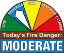
The Shelby County Emergency Management Agency said today (Monday), the Fire Danger Index in the county will remain in the “Moderate” category, through Thursday. Officials say they hope the rain that’s forecast over the next few days, will contribute to the “greening up” of the grassy areas. Persons planning to burn brush or grassy areas should be aware of the frontal activity in the area and the shifting of winds associated with frontal passing.
The EMA says it can assist individual farmers and businesses with the development of burns plans, to assess the safety of any particular burn. Those plans will be developed jointly with the Fire Chief of the Jurisdiction, and the property owners.
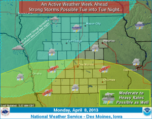
Low pressure will organize over Colorado today and move onto the Plains tonight and Tuesday. It will advance east through Missouri Wednesday and into the lower Great Lake Thursday night. Thunderstorms will develop tonight and continue intermittently through Tuesday night. Isolated severe storms are possible from Interstate 80 south. As the low passes to the east of Iowa, colder air will be drawn south into the region. The rain will gradually change to snow from the northwest. Accumulating snow will be restricted to far northwest Iowa and areas northwest with heavy snow possible. Moderate to heavy rainfall amounts over the next few days could result in ponding on roads and ditches Tuesday and Wednesday.
Leaders of the U-S Army Corps of Engineers will hold public meetings this week to cover water management plans for the Missouri River basin this spring and beyond. Jody Farhat, head of the Water Management Division for the Corps in Omaha, says it’s a chance to continue the dialogue with the public over how the river is being run during the drought. “The purpose of the April meetings is to let stakeholders in the basin know about the current hydrologic conditions, what the soil moisture and the snow pack looks like,” Farhat says, “and what we expect to do with regard to our operation of the reservoir system through the remainder of this calendar year.”
Farhat says they continue to see river reservoirs slowly dropping. So far, they’re down about eight-and-a-half million acre feet, or around 22-percent of the total storage available. “We are implementing drought conservation measures,” Farhat says. “We had low winter releases as a measure to conserve water and as we start the navigation season here in April, we’re providing what we call minimum service flows for navigation.”
Farhat says the Corps is in position to continue “near normal” operations for quite a while, several years, in fact. “Storage in the reservoirs is designed to serve the authorized purposes during a 12-year drought like that of the Dust Bowl era of the 1930s and early 1940s,” Farhat says. “As we get deeper and deeper into the drought, we conserve more and more water by providing reduced service to navigation and other uses.”
The region is just entering the second year of drought and she says, given the 12-year drought plan, they should be “good for another decade.” The meetings are being held this week in: Nebraska City, Nebraska; Fort Peck, Montana; Bismarck, North Dakota; Pierre, South Dakota and Smithville, Missouri.
(Radio Iowa)
NATIONAL WEATHER SERVICE DES MOINES IA 504 AM CDT MON APR 8 2013
COUNTIES: AUDUBON-GUTHRIE-CASS-ADAIR-MADISON-ADAMS-UNION-TAYLOR-RINGGOLD
AS SKIES CLEAR AND WINDS BECOME CALM EARLY THIS MORNING AREAS OF
DENSE FOG WILL DEVELOP…REDUCING VISIBILITY TO BELOW A QUARTER OF
A MILE AT TIMES. ANYONE ON THE ROADS SHOULD BE ALERT FOR RAPIDLY
CHANGING VISIBILITY.
Here’s the (Podcast) weather forecast for Atlantic and the KJAN listening area from Freese-Notis Meteorologist Harvey Freese, and weather data for Atlantic, from KJAN News Director Ric Hanson….
Podcast: Play in new window | Download (1.3MB)
Subscribe: RSS
345 AM CDT MON APR 8 2013
EARLY THIS MORNING…CLOUDY…WARMER. SOUTH WIND NEAR 10 MPH.
TODAY…PARTLY SUNNY. HIGH IN THE MID 70S. SOUTH WIND 5 TO 15 MPH.
TONIGHT…MOSTLY CLOUDY. A CHANCE OF THUNDERSTORMS THROUGH MIDNIGHT…THEN THUNDERSTORMS AFTER MIDNIGHT. LOW IN THE MID 50S. SOUTHEAST WIND 10 TO 15 MPH. CHANCE OF THUNDERSTORMS 90 PERCENT.
TUESDAY…COOLER. THUNDERSTORMS LIKELY THROUGH MID MORNING…THEN A CHANCE OF THUNDERSTORMS BEFORE NOON. THUNDERSTORMS LIKELY IN THE AFTERNOON. HIGH IN THE LOWER 60S. SOUTHEAST WIND 5 TO 15 MPH SHIFTING TO THE NORTHEAST WITH GUSTS TO AROUND 20 MPH IN THE AFTERNOON. CHANCE OF THUNDERSTORMS 70 PERCENT.
TUESDAY NIGHT…THUNDERSTORMS THROUGH MIDNIGHT…THEN SHOWERS AND ISOLATED THUNDERSTORMS AFTER MIDNIGHT. BREEZY…COLDER. LOW IN THE LOWER 40S. NORTH WIND 10 TO 20 MPH. CHANCE OF PRECIPITATION 90 PERCENT.
WEDNESDAY...LIGHT RAIN LIKELY. COLDER. HIGH IN THE MID 40S. NORTH WIND AROUND 15 MPH WITH GUSTS TO AROUND 25 MPH. CHANCE OF RAIN 60 PERCENT.
WEDNESDAY NIGHT…CLOUDY. A CHANCE OF LIGHT RAIN AND SNOW THROUGH MIDNIGHT…THEN A CHANCE OF LIGHT SNOW AFTER MIDNIGHT. COLDER. LOW AROUND 30. CHANCE OF PRECIPITATION 50 PERCENT.
THURSDAY…MOSTLY CLOUDY. A CHANCE OF SNOW POSSIBLY MIXED WITH RAIN IN THE MORNING…THEN A SLIGHT CHANCE OF RAIN IN THE AFTERNOON. HIGH IN THE LOWER 40S. CHANCE OF PRECIPITATION 30 PERCENT.
THURSDAY NIGHT THROUGH FRIDAY NIGHT…PARTLY CLOUDY. LOW IN THE UPPER 20S. HIGH IN THE MID 40S.
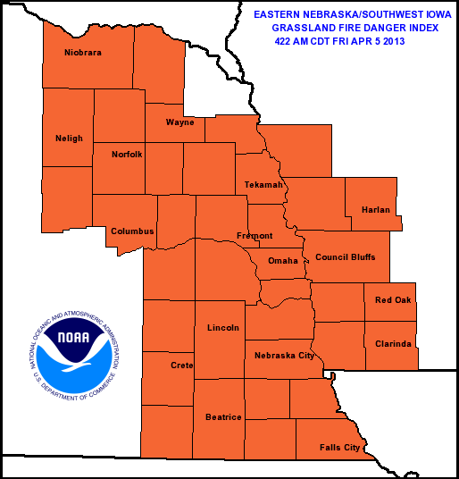
The National Weather Service in Omaha, and Montgomery County Emergency Management Agency say the Fire Weather category will remain in the VERY HIGH category today (Friday). Windy and warm conditions are expected. Southerly surface winds may gust up to 25-35 mph at times this afternoon. Officials say if you do burn today, to watch the fire closely as it can spread very rapidly.
Montgomery County Emergency Manager Brian Hamman says all controlled burns in Montgomery County should be reported to the Montgomery County Sheriff’s Office at 712-623-5107. Hamman says a burn ban is not expected at this time, but if dry conditions continue into the spring, another burn ban such as the one which last summer for 94 days, could be placed into effect.
DES MOINES, Iowa (AP) – Officials say nearly 7 percent of Iowa is no longer in drought. The Iowa Department of Natural Resources says in a report issued Thursday that conditions have returned to normal in a swath of southeast Iowa. The U.S. Drought Monitor map from the National Drought Mitigation Center shows the drought conditions are worse to the northwest, culminating in extreme drought in portions of northwest Iowa.
The drought center says that a year ago nearly 61 percent of Iowa had no drought. March rain in Iowa was a drop or two higher than the historical normal of 2.15 inches. It was the fourth consecutive month for higher-than-normal rainfall in the state.
The (podcast) weather forecast for Atlantic & the KJAN listening area from Freese-Notis, and weather data for Atlantic….
Podcast: Play in new window | Download (1.2MB)
Subscribe: RSS
415 AM CDT FRI APR 5 2013
EARLY THIS MORNING…MOSTLY CLEAR. NORTHEAST WIND 5 TO 10 MPH.
TODAY…PARTLY SUNNY. BREEZY. HIGH IN THE MID 60S. SOUTHEAST WIND 5 TO 15 MPH WITH GUSTS TO AROUND 25 MPH INCREASING TO SOUTH 15 TO 25 MPH WITH GUSTS TO AROUND 35 MPH IN THE AFTERNOON.
TONIGHT...PARTLY CLOUDY. ISOLATED THUNDERSTORMS EARLY IN THE MORNING. BREEZY…WARMER. LOW AROUND 50. SOUTH WIND 15 TO 20 MPH WITH GUSTS TO AROUND 30 MPH. CHANCE OF THUNDERSTORMS 20 PERCENT.
SATURDAY…PARTLY SUNNY. SCATTERED SHOWERS AND ISOLATED THUNDERSTORMS THROUGH MID MORNING. BREEZY. HIGH IN THE UPPER 60S. WEST WIND 15 TO 20 MPH WITH GUSTS TO AROUND 30 MPH. CHANCE OF PRECIPITATION 30 PERCENT.
SATURDAY NIGHT…PARTLY CLOUDY. COLDER. LOW AROUND 40. NORTHWEST WIND NEAR 5 MPH WITH GUSTS TO AROUND 20 MPH SHIFTING TO THE NORTHEAST AFTER MIDNIGHT.
SUNDAY…PARTLY SUNNY. SCATTERED SHOWERS AND ISOLATED THUNDERSTORMS IN THE AFTERNOON. HIGH IN THE MID 60S. EAST WIND 5 TO 10 MPH. CHANCE OF PRECIPITATION 30 PERCENT.
SUNDAY NIGHT…MOSTLY CLOUDY WITH A CHANCE OF SHOWERS AND ISOLATED THUNDERSTORMS. LOW IN THE MID 40S. CHANCE OF PRECIPITATION 50 PERCENT.
MONDAY…MOSTLY CLOUDY WITH A CHANCE OF SHOWERS AND ISOLATED THUNDERSTORMS. HIGH IN THE LOWER 60S. CHANCE OF PRECIPITATION 30 PERCENT.
MONDAY NIGHT…MOSTLY CLOUDY WITH A 50 PERCENT CHANCE OF THUNDERSTORMS. LOW IN THE UPPER 40S.