The (podcast) Freese-Notis weather forecast for Atlantic and the KJAN listening area, and weather data for Atlantic…
Podcast: Play in new window | Download (1,001.0KB)
Subscribe: RSS
359 AM CDT FRI APR 26 2013
EARLY THIS MORNING…PARTLY CLOUDY. NOT AS COOL. SOUTH WIND 10 TO 15 MPH.
TODAY…PARTLY SUNNY. BREEZY. HIGH IN THE UPPER 60S. SOUTH WIND 10 TO 20 MPH WITH GUSTS TO AROUND 30 MPH.
TONIGHT...MOSTLY CLOUDY. LOW IN THE UPPER 40S. SOUTH WIND NEAR 10 MPH.
SATURDAY…PARTLY SUNNY. HIGH IN THE UPPER 60S. SOUTHEAST WIND NEAR 5 MPH.
SATURDAY NIGHT AND SUNDAY…MOSTLY CLEAR. LOW IN THE UPPER 40S. HIGH IN THE UPPER 70S. SOUTH WIND 5 TO 15 MPH WITH GUSTS TO AROUND 25 MPH.
SUNDAY NIGHT…PARTLY CLOUDY WITH A 40 PERCENT CHANCE OF THUNDERSTORMS. LOW IN THE MID 50S.
MONDAY AND MONDAY NIGHT…PARTLY CLOUDY. A 20 PERCENT CHANCE OF THUNDERSTORMS. HIGH IN THE MID 70S. LOW IN THE UPPER 50S.
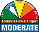
The Shelby County Emergency Management Agency says due to a warming trend, the likelihood of increased winds and a dryer forecast over the next few days, the fire danger rating will be bumped up to “MODERATE,” through Monday, April 29th. The fire danger index had been in the “Low” category for more than a week, because of recent rains.
Controlled burns should be monitored closely, and property owners should contact their local fire chief before any burns are initiated.
A self-described “storm chaser” says it’s getting more hazardous to pursue his passion, not because of severe weather but due to so many amateurs who also chase storms. Jon Davies is a Kansas City-based meteorologist who seeks out destructive weather systems, though he knows storm chasers have a bad reputation for putting themselves in harm’s way. “Storm chasing can be exciting and dangerous at times,” Davies says. “Unlike those characters in ‘Twister,’ we see Bill Paxton and Helen Hunt, unlike them, I don’t tie myself to a pipe in a barn with sharp instruments around, above ground when an EF-5 tornado is bearing down.”
That 1996 film was shot partly in Iowa. While tornadoes can strike in any month, we’re now starting tornado season in Iowa. Davies, who saw his first tornado at age nine, says storm chasers can be grouped into four categories: researchers, amateur hobbyists, storm tour operators and media chasers. “Of course, with the movie ‘Twister’ and all these TV shows like The Discovery Channel’s ‘Storm Chasers,’ there’s more traffic out there these days,” Davies says. “Sometimes, things get kind of crowded out there. The weather isn’t the most dangerous thing out there sometimes now, it’s the traffic.”
Davies chased an EF-4 twister that killed 13 people at a mobile home park in Andover, Kansas, in 1991. Davis also chased the Daykin-to-Hallam tornado in Nebraska, a destructive twister nine years ago that remained on the ground for more than 50 miles. Davies says storm chasers need to be especially cautious when encountering rain-wrapped tornadoes or those that strike at night. “I do encourage people who want to storm chase, don’t treat it casually like, ‘I think I’ll go out there and look at that storm and put my family in the car to do it,’ you need to know what you’re doing and you also need to not block the roads.”
Davies worked at The Weather Channel in the 1980s and got into storm chasing, which he says is his motivation for researching the weather. He’s published research on components of instability and wind shear and the probability of major tornadoes forming. He and his wife have published a book for kids: “Storm Chasers! On the Trail of Twisters.”
(Radio Iowa)
Here’s the (podcast) Freese-Notis forecast for Atlantic & the KJAN listening area, and weather data for Atlantic…
Podcast: Play in new window | Download (923.0KB)
Subscribe: RSS
SPECIAL WEATHER STATEMENT 531 PM CDT WED APR 24 2013
AUDUBON-CALHOUN-CARROLL-CRAWFORD-GREENE-GUTHRIE-SAC-WEBSTER-
531 PM CDT WED APR 24 2013
…GUSTY WINDS EXPECTED WITH A LINE OF THUNDERSTORMS…
AT 530 PM CDT…NATIONAL WEATHER SERVICE DOPPLER RADAR INDICATED
THUNDERSTORMS ALONG A LINE EXTENDING FROM 34 MILES NORTH OF CARROLL
TO 14 MILES NORTH OF DENISON TO 32 MILES WEST OF DENISON…MOVING
EAST AT 40 MPH.
Here’s the Freese-Notis (podcast) weather forecast for Atlantic & the KJAN listening area, and weather data for Atlantic….
Podcast: Play in new window | Download (900.6KB)
Subscribe: RSS
4:10 AM CDT WED APR 24 2013
EARLY THIS MORNING…CLEAR. NORTHWEST WIND AROUND 5 MPH.
TODAY…MOSTLY SUNNY. A SLIGHT CHANCE OF RAIN SHOWERS AND ISOLATED THUNDERSTORMS LATE IN THE AFTERNOON. BREEZY…WARMER. HIGH IN THE MID 50S. WEST WIND 5 TO 15 MPH INCREASING TO 15 TO 20 MPH WITH GUSTS TO AROUND 30 MPH IN THE AFTERNOON. CHANCE OF PRECIPITATION 20 PERCENT.
TONIGHT...PARTLY CLOUDY. A CHANCE OF LIGHT RAIN SHOWERS AND ISOLATED THUNDERSTORMS IN THE EVENING…THEN A SLIGHT CHANCE OF LIGHT RAIN SHOWERS BEFORE MIDNIGHT. BREEZY. LOW IN THE UPPER 20S. NORTHWEST WIND 5 TO 20 MPH. CHANCE OF PRECIPITATION 50 PERCENT.
THURSDAY…MOSTLY SUNNY. HIGH IN THE UPPER 50S. SOUTHWEST WIND 5 TO 15 MPH.
THURSDAY NIGHT...MOSTLY CLEAR. NOT AS COOL. LOW IN THE LOWER 40S. SOUTH WIND 10 TO 15 MPH.
FRIDAY…PARTLY SUNNY. HIGH IN THE UPPER 60S. SOUTH WIND 10 TO 15 MPH WITH GUSTS TO AROUND 25 MPH.
FRIDAY NIGHT THROUGH SATURDAY NIGHT…PARTLY CLOUDY. LOW IN THE UPPER 40S. HIGH IN THE LOWER 70S.
SUNDAY THROUGH MONDAY…PARTLY CLOUDY. HIGH IN THE UPPER 70S. LOW IN THE MID 50S.
The Freese-Notis (podcast) weather forecast for Atlantic & the KJAN listening area, and weather data (including precipitation) for Atlantic from KJAN News Director Ric Hanson…
Podcast: Play in new window | Download (1.1MB)
Subscribe: RSS