
Today: A chance of showers and thunderstorms. Cloudy, with a high near 70. South wind 8 to 11 mph. Chance of precipitation is 50%. New rainfall amounts between a tenth and quarter of an inch, except higher amounts possible in thunderstorms.
Tonight: A slight chance of showers, then a chance of showers and thunderstorms after 9pm. Mostly cloudy, with a low around 56. Southeast wind around 11 mph. Chance of precipitation is 40%. New rainfall amounts of less than a tenth of an inch, except higher amounts possible in thunderstorms.
Saturday: A chance of showers and thunderstorms before 1pm, then a slight chance of showers between 1pm and 4pm, then a slight chance of showers and thunderstorms after 4pm. Cloudy, then gradually becoming mostly sunny, with a high near 81. Southeast wind 10 to 14 mph, with gusts as high as 20 mph. Chance of precipitation is 40%.
Sunday: A 20 percent chance of showers and thunderstorms after 1pm. Sunny, with a high near 85.
Monday: A 30 percent chance of showers after 1pm. Mostly sunny, with a high near 81.
Thursday’s High in Atlantic was 82. The Low was 36. Last year on this date the High in Atlantic was 57 and the Low was 49. The Record High on this date was 96 in 1909. The Record Low was 28 in 2021. Sunrise is at 6:12. Sunset will occur at 8:22.
(Radio Iowa) – Areas of Iowa that have suffered through months of drought may see some relief soon with the development of an El Nino weather pattern, as the Climate Prediction Center has issued an El Nino Watch for this summer. Doug Kluck, the Central Region climate service director for the National Weather Service, says the El Nino would come after three years of a La Nina. “If this does turn into an El Nino, and it turns into a moderate and/or strong one, it is the opposite of what we expect from a La Nina,” Kluck says. “In the wintertime, El Nino brings warmer-than-normal temperatures in the northern states, cooler-than-normal temperatures in the southern states, and wetter conditions along the south and drier conditions along the north.”
An El Nino occurs when Pacific Ocean surface temperatures rise above normal, and for Iowa, it typically means moderate temperatures and better chances for precipitation. Kluck says weather patterns change under an El Nino. “It tends to have a split jetstream, meaning, that the southern part of the U.S. gets more activity. The northern part, is sort of the northern jet, if you will, splits over the top, it stays in Canada. We don’t get as many arctic air pushes, it doesn’t get as cold and we have a relatively warm winter.”
Kluck says the El Nino is expected to develop rapidly this summer. Parts of Woodbury and Monona counties are in the worst categories of drought: exceptional, extreme and severe, while moderate to severe drought extends across wide sections of western Iowa. Large areas of central and eastern Iowa are considered extremely dry by the U-S Drought Monitor.
(Radio Iowa) – Iowans may have seen on the news how Michigan’s Upper Peninsula was hit on Monday with a foot-and-a-half of snow. Ten years ago this week, Iowans were the ones who were stunned with heavy snow in the first days of May, well over a month into spring. Meteorologist Rod Donavon, at the National Weather Service, says May of 2013 was a month of surprise weather extremes for Iowa. “Ten years ago, we had a lot of accumulating snowfall, a lot of those really wet and heavy snowfalls as well,” Donavon says. “We actually had several areas that reported power outages with that, and usually this time of year, you don’t expect travel concerns either, but it just came down so wet and heavy that we actually had some slick travel conditions as well.”
Much of the state had at least six inches of snow, while Mason City had more than nine inches, Chariton reported a foot of snow, and Osage had the deepest report at 13 inches. While there was significant snowfall, Donavon says it didn’t stick around. “It doesn’t take too long for snow this time of year to really melt and disappear,” Donavon says. “It’s really warming up. We were actually pretty cold here in the last week as well, and then now, we’re going to be warming up as well. This time of year, usually if we get some snowfall, it doesn’t last.”

May 2013 snowstorm (Pella)
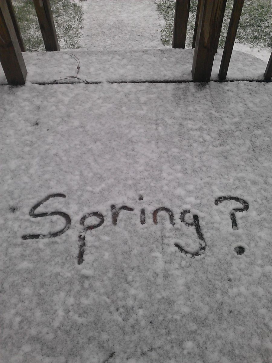
May 2013 snowstorm (Indianola)

May 2013 snowstorm (Belmond, IA)
Within a week of the big snowstorm in May of 2013, many Iowans were switching on their air conditioners, as temperatures by May 14th were already soaring to 98 degrees. (Photos courtesy the NWS in Des Moines. Click to enlarge)
Todday: Sunny, with a high near 79. South wind 5 to 14 mph.
Tonight: A 30 percent chance of showers and thunderstorms, mainly after 3am. Increasing clouds, with a low around 54. South southeast wind 8 to 13 mph. New rainfall amounts between a tenth and quarter of an inch, except higher amounts possible in thunderstorms.
Friday: A 50 percent chance of showers and thunderstorms. Cloudy, with a high near 71. Southeast wind 8 to 11 mph. New rainfall amounts between a quarter and half of an inch possible.
Friday Night: A 30 percent chance of showers and thunderstorms. Mostly cloudy, with a low around 54. East southeast wind 10 to 14 mph, with gusts as high as 20 mph. New rainfall amounts between a tenth and quarter of an inch, except higher amounts possible in thunderstorms.
Saturday: A slight chance of showers and thunderstorms before 1pm, then a chance of showers between 1pm and 4pm, then a chance of showers and thunderstorms after 4pm. Partly sunny, with a high near 77. Breezy. Chance of precipitation is 30%.
Saturday Night: A 40 percent chance of showers and thunderstorms, mainly before 1am. Partly cloudy, with a low around 54.
Sunday: A slight chance of showers, then a chance of showers and thunderstorms after 1pm. Mostly sunny, with a high near 85. Chance of precipitation is 30%.
Wednesday’s High in Atlantic was 73. The Low was 29. Last year on this date the High in Atlantic was 55 and the Low was 46. The Record High on this date was 91 in 1918. The Record Low was 18 in 1907. Sunrise is at 6:14. Sunset will take place at 8:21.
Today: Areas of frost before 8am. Otherwise, sunny, with a high near 71. North northwest wind around 6 mph becoming west southwest in the afternoon.
Tonight: Mostly clear, with a low around 44. South southeast wind 6 to 8 mph.
Tomorrow: A slight chance of showers between 3pm and 4pm, then a slight chance of showers and thunderstorms after 4pm. Mostly sunny, with a high near 77. Breezy, with a south wind 9 to 16 mph, with gusts as high as 21 mph. Chance of precipitation is 20%.
Tomorrow Night: A 40 percent chance of showers and thunderstorms. Mostly cloudy, with a low around 52. South wind 7 to 13 mph. New rainfall amounts of less than a tenth of an inch, except higher amounts possible in thunderstorms.
Friday: A chance of showers, with thunderstorms also possible after 1pm. Mostly cloudy, with a high near 70. Chance of precipitation is 40%. New rainfall amounts of less than a tenth of an inch, except higher amounts possible in thunderstorms.
Friday Night: A 30 percent chance of showers and thunderstorms, mainly before 1am. Mostly cloudy, with a low around 53.
Saturday: A 20 percent chance of showers. Partly sunny, with a high near 77. Breezy.
Tuesday’s High in Atlantic was 66. Our Low this morning was 27. Last year on this date the High in Atlantic was 52 and the Low was 41. The Record High on this date was 87 in 1895, 1949 & 1968. The Record Low was 25 in 1900. Sunrise is at 6:14. Sunset will take place at 8:19.
(Radio Iowa) – To many Iowans, it seems like winter ran long this year, with plenty of springtime snowstorms and frigid wind chills, but it turns out that our temperatures were right on target during April. State climatologist Justin Glisan says there were extremes on both ends of the thermometer, but it all averaged out to be normal for the month.
“If we look at the statewide average temperature, it was right on the average of 49 degrees,” Glisan says. “We did have pockets of slightly above average temperatures in southwestern Iowa, and then over into eastern Iowa, but overall, near-normal temperatures across the state.” There was severe weather on April 4th that included large hail, high winds and several funnel clouds and tornadoes, as well as multiple bouts with snow during the month, but overall, Iowa was lacking for rainfall during April.
“So if we look at the statewide average, it was a little over two inches, and that’s about an inch and a half below average,” Glisan says, “with the driest part of the state down in southeastern Iowa, with departures of up to one to three inches below average.” Computer models are pointing to a continued dry spell for the month ahead, while Glisan says the immediate forecast looks about right.
“Basically, across the upper Midwest and through the Corn Belt, an elevated signal for drier conditions in May,” Glisan says, “and May is the second wettest month climatologically for the state with almost five inches, so we don’t like to see that dry signal, but at least in the short term, we are seeing near-normal precipitation.”
Forecasters anticipate an El Nino weather pattern will develop over the region within the next few months, which typically means moderate temperatures and better chances for precipitation.
Today: Sunny, with a high near 64. Windy, with a north northwest wind 13 to 22 mph, with gusts as high as 31 mph.
Tonight: Clear, with a low around 34. Breezy, with a north northwest wind 6 to 16 mph, with gusts as high as 23 mph.
Wednesday: Sunny, with a high near 71. Light and variable wind becoming west around 6 mph in the afternoon.
Thursday: A slight chance of showers, with thunderstorms also possible after 4pm. Mostly sunny, with a high near 75. Chance of precipitation is 20%.
Friday: A chance of showers and thunderstorms before 7am, then a chance of showers between 7am and 1pm, then a chance of showers and thunderstorms after 1pm. Mostly cloudy, with a high near 72. Chance of precipitation is 30%.
Monday’s High in Atlantic was 64. Our Low this morning, 35. Last year on this date the High in Atlantic was 45 and the Low was 37. The Record High on this date was 91 in 1968. The Record Low was 17 in 1908. Sunrise is at 6:15. Sunset will take place at 8:18.
(Radio Iowa) – The eastern Iowa cities along the Mississippi River had to put their flood control measures into place, but have averted any major problems as the river crests today (Monday). National Weather Service Meteorologist, Matt Wilson, says the lack of any rain to go with the slug of water coming downriver from Minnesota snow melt kept the water from surpassing the record.
“We have been very lucky that we haven’t had any significant rainfall to come in on top of this crest. It’s been pretty straightforward for the last week or so, pretty dry here,” he says.”And even up north, we didn’t have too much extra rainfall up there in the last week or so.” He says the Mississippi River rarely rises to the level they are seeing without rainfall contributing to the flood conditions. Wilson is in the N-W-S Quad Cities office and says these high waters are passing without big damage.
“We haven’t had any reports of any type of major levee failure or any kind of major damage in protected areas along the river. Obviously, in the unprotected lowlands along the river, the river rose to its level and affected any structures or roadways that were there,” Wilson says. “But anywhere that was behind a flood wall — by and large we haven’t heard of any damages behind that.” He says there were reports of two minor levee breaks. One was at the Green Island Wildlife Management Area.
“Just south of Bellevue. No structures or roads were impacted by that one. And then another one in Commanche, Iowa, where it was quickly sandbagged. And they had the pumps going so before anybody even really knew that what was going on the crews there were already taking care of it,” he says. Wilson says the forecast is good for allowing the waters to recede.
“Over the next week, we’re expecting broadly, no more than an inch of rain across the states of Iowa and Illinois. And then for the next eight to 14 days after that, we’re also expecting below-average chances for precipitation,” Wilson says. Wilson says that lack of rain should allow the river to go down at a faster rate than normal.
“By the end of May, we’ll have pretty much every site here in Iowa back down below flood stage,” he says. The crest is going to end up somewhere around 21-point-four feet to 21-point-five feet — which would be below the record crest.
(Atlantic, Iowa/KJAN) – The month of April, in Atlantic, was slightly warmer than average, for the most part. Our average high for the month was 64, while the average low was 36. Weather records at KJAN show the normal average High during April is 62 and the Low 37. Rainfall last month came in nearly one-inch below normal, at 2.53-inches. Ordinarily, that would be 3.43-inches.
The warmest day in April was 85, on the 12th. The coolest mornings, with 13 degrees each, occurred on April 5th & 6th.
Here’s what we should expect weather-wise, for May, in Atlantic: An average High of 73, and an average Low of 49. Precipitation typically amounts to 4.32-inches. KJAN is the OFFICIAL National Weather Service reporting site for Atlantic data.
Today: Sunny, with a high near 60. Windy, with a northwest wind 16 to 25 mph, with gusts as high as 32 mph.
Tonight: Clear, with a low around 35. Breezy, with a northwest wind 14 to 20 mph, with gusts as high as 28 mph.
Tomorrow: Sunny, with a high near 62. Windy, with a north northwest wind 15 to 21 mph, with gusts as high as 28 mph.
Wednesday: Sunny, with a high near 70.
Thursday: A slight chance of showers, with thunderstorms also possible after 1pm. Partly sunny, with a high near 75. Chance of precipitation is 20%.
Sunday’s High in Atlantic was 61. Our Low this morning, 39. Last year on this date the High in Atlantic was 55 and the Low was 35. The Record High on this date was 90 in 1965. The Record Low was 24 in 1909. Sunrise is at 6:17-a.m. Sunset is at 8:17-p.m.


