
Today: Isolated showers and thunderstorms after 4pm. Partly sunny, with a high near 80. Southwest wind 7 to 13 mph. Chance of precipitation is 20%.
Tonight: Scattered showers and thunderstorms, mainly before midnight. Patchy smoke after midnight. Mostly cloudy, with a low around 52. West wind 6 to 11 mph becoming north after midnight. Winds could gust as high as 18 mph. Chance of precipitation is 40%.
Friday: Mostly sunny, with a high near 67. Breezy, with a north wind 14 to 16 mph, with gusts as high as 23 mph.
Saturday: Sunny, with a high near 73.
Sunday: Sunny, with a high near 79.
Wednesday’s High in Atlantic was 84. The Low was 49. Last year on this date the High in Atlantic was 84 and the Low was 58. The Record High on this date was 94 in 1934. The Record Low was 32 in 1891. Sunrise is 5:59. Sunset at 8:35.
Today: Mostly sunny, with a high near 81. North northwest wind around 6 mph becoming southeast in the afternoon.
Tonight: Partly cloudy, with a low around 56. Southeast wind around 9 mph.
Tomorrow: A chance of showers between 1pm and 4pm, then a chance of showers and thunderstorms after 4pm. Partly sunny, with a high near 81. Southwest wind 8 to 15 mph, with gusts as high as 18 mph. Chance of precipitation is 40%. New rainfall amounts between a tenth and quarter of an inch, except higher amounts possible in thunderstorms.
Tom. Night: A chance of showers and thunderstorms before 4am, then a slight chance of showers. Partly cloudy, with a low around 52. West southwest wind 7 to 13 mph becoming north after midnight. Winds could gust as high as 20 mph. Chance of precipitation is 50%. New rainfall amounts between a tenth and quarter of an inch, except higher amounts possible in thunderstorms.
Friday: Sunny, with a high near 68. Breezy.
Saturday: Sunny, with a high near 72.
Tuesday’s High in Atlantic was 80. Our Low this morning was 48. Last year on this date the High in Atlantic was 78 and the Low was 56. The Record High on this date was 92 in 1908 & 1939. The Record Low was 32 in 1912 & 1973. Sunrise is at 6:00. Sunset will be at 8:34.
Today: Mostly cloudy, then gradually becoming sunny, with a high near 76. North northwest wind 6 to 8 mph.
Tonight: Mostly clear, with a low around 51. West northwest wind 5 to 7 mph.
Wednesday: Sunny, with a high near 81. North northwest wind around 6 mph becoming calm.
Thursday: A 30 percent chance of showers and thunderstorms after 1pm. Mostly sunny, with a high near 80. New rainfall amounts of less than a tenth of an inch, except higher amounts possible in thunderstorms.
Friday: A 30 percent chance of showers, mainly before 1pm. Mostly sunny, with a high near 68. Breezy.
Monday’s (24-hour) High in Atlantic was 56. The Low was 51. We received .11” rain, Monday. Last year on this date the High in Atlantic was 82 and the Low was 46. The Record High on this date was 93 in 1939. The Record Low was 25 in 1907. Sunrise is 6:01. Sunset is 8:33.
Today: Showers likely, mainly before 1pm. Cloudy, with a high near 58. East northeast wind 10 to 13 mph, with gusts as high as 22 mph. Chance of precipitation is 60%. New precipitation amounts of less than a tenth of an inch possible.
Tonight: Cloudy, with a low around 52. North northeast wind 6 to 8 mph becoming northwest after midnight.
Tuesday: Mostly cloudy, then gradually becoming sunny, with a high near 76. North northwest wind 7 to 10 mph.
Wednesday: Sunny, with a high near 79.
Thursday: A 30 percent chance of showers and thunderstorms after 1pm. Partly sunny, with a high near 79. Breezy.
Sunday’s High in Atlantic was 74. Our Low this morning, 52. We received just a trace of rain early this morning, in the form of sprinkles & drizzle. Last year on this date the High in Atlantic was 70 and the Low was 44. The Record High on this date was 91 in 1894 & 2017. The Record Low was 29 in 1929, 1973 and 1983. Sunrise is 6:02. Sunset at 8:32.
Today: A chance of showers, with thunderstorms also possible after 4pm. Cloudy, with a high near 71. Breezy, with an east northeast wind 5 to 10 mph increasing to 11 to 16 mph in the afternoon. Winds could gust as high as 20 mph. Chance of precipitation is 40%. New rainfall amounts of less than a tenth of an inch, except higher amounts possible in thunderstorms.
Tonight: A chance of showers and thunderstorms. Cloudy, with a low around 49. Breezy, with an east northeast wind 14 to 16 mph, with gusts as high as 25 mph. Chance of precipitation is 40%. New precipitation amounts of less than a tenth of an inch, except higher amounts possible in thunderstorms.
Monday: A 20 percent chance of showers before 1pm. Cloudy, with a high near 62. East northeast wind 10 to 13 mph, with gusts as high as 22 mph.
Tuesday: Mostly sunny, with a high near 75. Northwest wind 8 to 10 mph.
Wednesday: Sunny, with a high near 78.
Saturday’s High in Atlantic was 82. Our Low this morning, 62. Last year on this date, the High in Atlantic was 86, and the Low was 46. The All-time Record High on May 14th in Atlantic was 97 in 2013. The Record Low was 29, in 1937. Sunrise is 6:03. Sunset is 8:31.
(Nebraska/Iowa) – Parts of central and eastern Nebraska were hit by tornadoes and large hail, Friday, while heavy rain caused street flooding in western Iowa. The National Weather Service in Valley, NE, says in western Iowa, thunderstorm winds caused damage in Hamburg at around 6:45-p.m., with tree limbs broken and shingles blown-off of roofs.
Flash flooding was reported at around 8:25-p.m. in Onawa, where streets were closed and vehicles were left stranded. Rain amounting to 4.4-inches was recorded in Harrison County, about three-miles west of Magnolia, at around 11-p.m., Friday.
Tornadoes and large hail were observed near Ames, Bend, Boone, Colfax, Hooper, North Bend, Oakland, Pawnee, Platte, Scribner, NE, and at least four other communities, with funnel clouds seen elsewhere in the southeastern part of the Cornhusker State.
Damage reports were received from numerous parts of the affected area, but there were no immediate reports of injuries or deaths.
Today: Partly sunny, with a high near 79. South southeast wind 9 to 13 mph, with gusts as high as 18 mph.
Tonight: Mostly cloudy, with a low around 60. Southwest wind 5 to 8 mph becoming east northeast after midnight.
Sunday: A 40 percent chance of showers. Cloudy, with a steady temperature around 64. Breezy, with a northeast wind 7 to 17 mph, with gusts as high as 23 mph. New precipitation amounts of less than a tenth of an inch possible.
Monday: Mostly cloudy, with a high near 70.
Tuesday: Mostly sunny, with a high near 76.
Friday’s High in Atlantic was 77. Our Low this morning, 66. We received .01” rain overnight into early this morning. Last year on this date the High in Atlantic was 80 and the Low was 47. The Record High on this date was 95 in 1915. The Record Low was 23 in 1997.
(Des Moines, Iowa) -The National Weather Service, in their Hazardous Weather Outlook, says scattered thunderstorms are expected to develop over western Iowa late this afternoon and spread into parts of central Iowa through the evening hours. A few strong to severe storms are possible with large hail and damaging winds. A low tornado threat does exist.
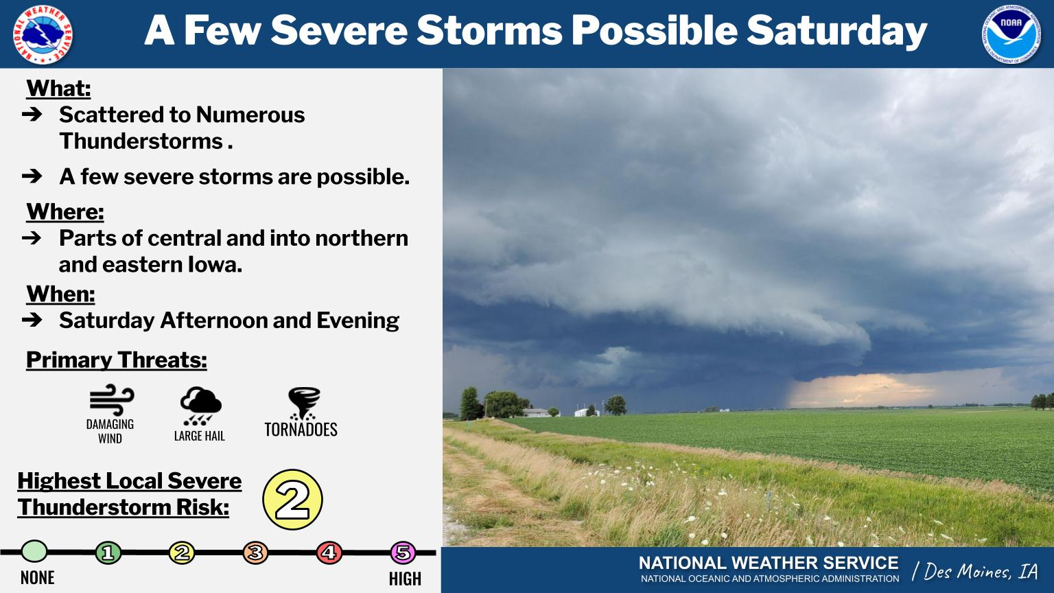
Another chance for thunderstorms arrives on Saturday. A few strong or even severe storms could occur once again. Sunday and Monday will be cooler with highs in the 60s to low 70s before warmer temperatures return for Tuesday through Thursday. A few showers or isolated storms may linger on Sunday then mostly dry conditions will follow. 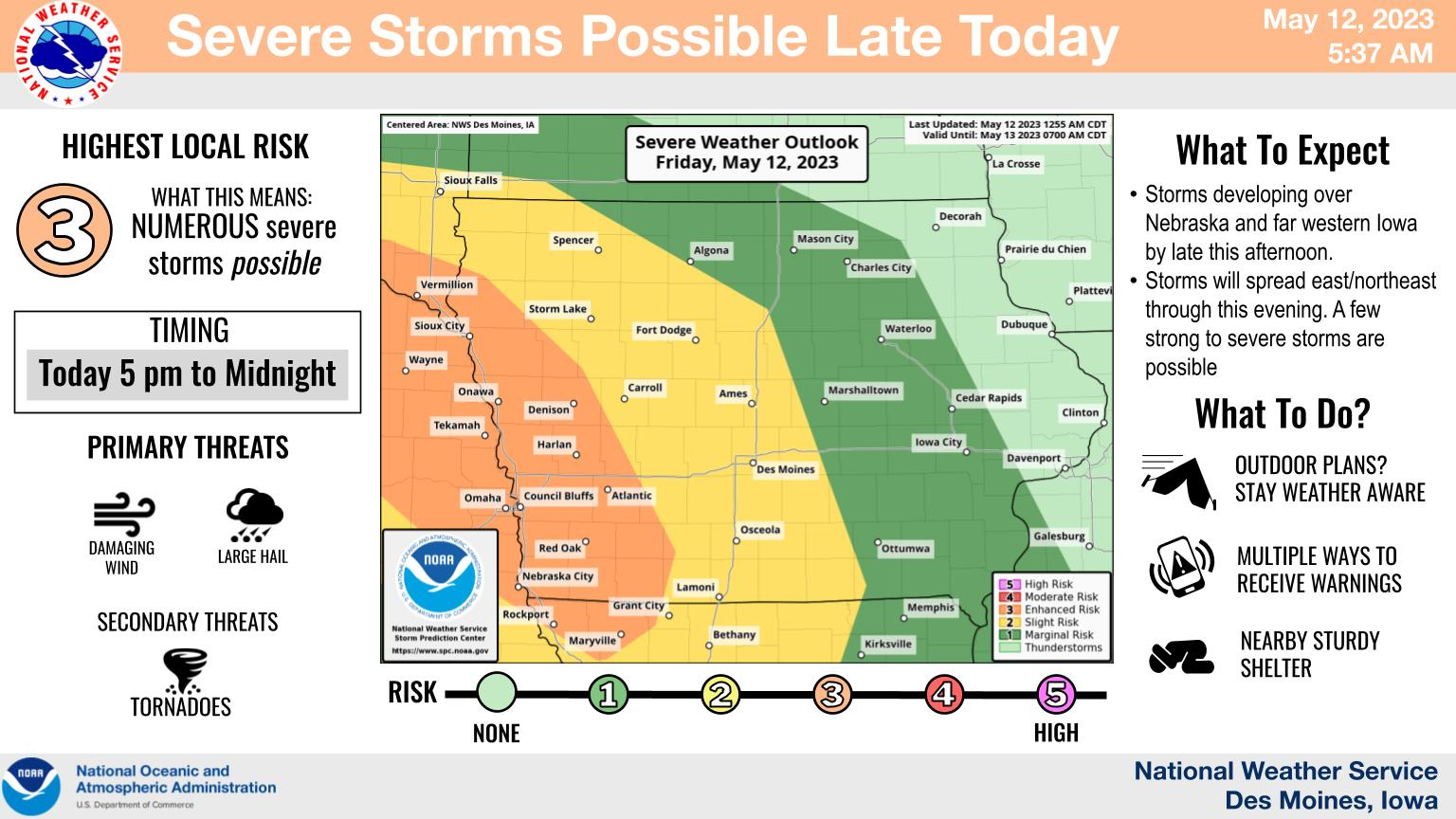
Spotters may be needed at times late today through Saturday.
Today: A slight chance of showers before 10am, then a slight chance of showers and thunderstorms after 5pm. Mostly cloudy, with a high near 81. Southeast wind 9 to 14 mph, with gusts as high as 18 mph. Chance of precipitation is 20%.
Tonight: Showers and thunderstorms, mainly before midnight. Low around 60. Southeast wind 11 to 13 mph, with gusts as high as 21 mph. Chance of precipitation is 80%. New rainfall amounts between a tenth and quarter of an inch, except higher amounts possible in thunderstorms.
Saturday: A 30 percent chance of showers and thunderstorms, mainly after 4pm. Partly sunny, with a high near 79. South wind 10 to 13 mph. New rainfall amounts of less than a tenth of an inch, except higher amounts possible in thunderstorms.
Saturday Night: A chance of showers and thunderstorms. Mostly cloudy, with a low around 58. Southwest wind 7 to 9 mph becoming north after midnight. Chance of precipitation is 40%. New rainfall amounts of less than a tenth of an inch, except higher amounts possible in thunderstorms.
Sunday: A chance of showers before 1pm, then a chance of showers and thunderstorms between 1pm and 4pm, then a chance of showers after 4pm. Mostly cloudy, with a high near 71. Breezy. Chance of precipitation is 50%. New rainfall amounts of less than a tenth of an inch, except higher amounts possible in thunderstorms.
Monday: Mostly cloudy, with a high near 70.
Thursday’s High in Atlantic was 81. The Low was 62. We received .22” rain overnight. Last year on this date the High in Atlantic was 91 and the Low was 60. The Record High on this date was 94 in 1956. The Record Low was 25 in 1895.


