
SEVERE WEATHER STATEMENT
NATIONAL WEATHER SERVICE DES MOINES IA
407 PM CDT SAT MAY 10 2014
…A SEVERE THUNDERSTORM WARNING REMAINS IN EFFECT UNTIL 430 PM CDT FOR SOUTHWESTERN GUTHRIE AND NORTHERN ADAIR COUNTIES…
AT 407 PM CDT…A SEVERE THUNDERSTORM WAS LOCATED 7 MILES NORTHWEST OF GREENFIELD…MOVING EAST AT 25 MPH.
HAZARD…60 MPH WIND GUSTS AND QUARTER SIZE HAIL.
SOURCE…RADAR INDICATED.
IMPACT…HAIL DAMAGE TO VEHICLES IS EXPECTED. EXPECT WIND DAMAGE TOROOFS…SIDING AND TREES.
LOCATIONS IMPACTED INCLUDE…
GREENFIELD…GUTHRIE CENTER…ADAIR…FONTANELLE…CASEY…GREENFIELDMUNICIPAL AIRPORT AND NODAWAY PARK.
THIS INCLUDES INTERSTATE 80 BETWEEN MILE MARKERS 74 AND 87.
PRECAUTIONARY/PREPAREDNESS ACTIONS…
FOR YOUR PROTECTION MOVE TO AN INTERIOR ROOM ON THE LOWEST FLOOR OF A
BUILDING.
BULLETIN – IMMEDIATE BROADCAST REQUESTED
SEVERE THUNDERSTORM WARNING
NATIONAL WEATHER SERVICE DES MOINES IA
341 PM CDT SAT MAY 10 2014
THE NATIONAL WEATHER SERVICE IN DES MOINES HAS ISSUED A
* SEVERE THUNDERSTORM WARNING FOR…
EASTERN CASS COUNTY IN SOUTHWEST IOWA…
SOUTHEASTERN AUDUBON COUNTY IN WEST CENTRAL IOWA…
SOUTHWESTERN GUTHRIE COUNTY IN WEST CENTRAL IOWA…
NORTHERN ADAIR COUNTY IN SOUTHWEST IOWA…
* UNTIL 430 PM CDT
* AT 340 PM CDT…A SEVERE THUNDERSTORM WAS LOCATED 10 MILES EAST OF
ATLANTIC…MOVING EAST AT 30 MPH. A SECOND SEVERE THUNDERSTORM WAS
LOCATED BETWEEN CUMBERLAND AND MASSENA MOVING EAST AT 30 MPH.
HAZARD…60 MPH WIND GUSTS AND QUARTER SIZE HAIL.
SOURCE…RADAR INDICATED.
IMPACT…HAIL DAMAGE TO VEHICLES IS EXPECTED. EXPECT WIND DAMAGE
TO ROOFS…SIDING AND TREES.
* LOCATIONS IMPACTED INCLUDE…
GREENFIELD…GUTHRIE CENTER…ANITA…ADAIR…FONTANELLE…CASEY…
MASSENA…CUMBERLAND…BRIDGEWATER…WIOTA…NODAWAY PARK…LAKE
ANITA STATE PARK…GREENFIELD MUNICIPAL AIRPORT AND ANITA MUNICIPAL
AIRPORT.
THIS INCLUDES INTERSTATE 80 BETWEEN MILE MARKERS 61 AND 87.
PRECAUTIONARY/PREPAREDNESS ACTIONS…
FOR YOUR PROTECTION MOVE TO AN INTERIOR ROOM ON THE LOWEST FLOOR OF A
BUILDING.
CASS IA-ADAIR IA-
312 PM CDT SAT MAY 10 2014
…A SEVERE THUNDERSTORM WARNING REMAINS IN EFFECT UNTIL 345 PM CDT
FOR CASS AND WESTERN ADAIR COUNTIES…
AT 312 PM CDT…A SEVERE THUNDERSTORM WAS LOCATED OVER ATLANTIC…
MOVING EAST AT 35 MPH. A SECOND STRONG THUNDERSTORM WAS LOCATED
SOUTHEAST OF GRISWOLD AND MAY CONTAIN PENNY SIZE HAIL.
HAZARD…60 MPH WIND GUSTS AND QUARTER SIZE HAIL.
SOURCE…RADAR INDICATED.
IMPACT…HAIL DAMAGE TO VEHICLES IS EXPECTED. EXPECT WIND DAMAGE TO
ROOFS…SIDING AND TREES.
LOCATIONS IMPACTED INCLUDE…
ATLANTIC…GRISWOLD…ANITA…FONTANELLE…LEWIS…MASSENA…
CUMBERLAND…BRIDGEWATER…WIOTA…GRISWOLD PARK…LAKE ANITA STATE
PARK…ATLANTIC MUNICIPAL AIRPORT…ANITA MUNICIPAL AIRPORT AND COLD
SPRINGS STATE PARK.
THIS INCLUDES INTERSTATE 80 BETWEEN MILE MARKERS 79 AND 82.
PRECAUTIONARY/PREPAREDNESS ACTIONS…
FOR YOUR PROTECTION MOVE TO AN INTERIOR ROOM ON THE LOWEST FLOOR OF A
BUILDING.
246 PM CDT SAT MAY 10 2014
**Severe Thunderstorm Watch until 10-p.m. for Adams, Fremont, Mills, Mongtomery, Page, Ringgold Taylor and Union Counties**
LATE THIS AFTERNOON…PARTLY SUNNY WITH SCATTERED THUNDERSTORMS. BREEZY. SOUTH WIND 15 TO 20 MPH. CHANCE OF THUNDERSTORMS 40 PERCENT.
TONIGHT…MOSTLY CLOUDY THEN BECOMING PARTLY CLOUDY BEFORE MIDNIGHT AND EARLY MORNING THEN BECOMING MOSTLY CLOUDY. SCATTERED THUNDERSTORMS IN THE EVENING…THEN ISOLATED THUNDERSTORMS BEFORE MIDNIGHT. SCATTERED THUNDERSTORMS EARLY IN THE MORNING. LOW IN THE MID 50S. SOUTHEAST WIND NEAR 10 MPH. CHANCE OF THUNDERSTORMS 50 PERCENT.
SUNDAY…THUNDERSTORMS UNTIL LATE AFTERNOON…THEN THUNDERSTORMS LIKELY LATE IN THE AFTERNOON. BREEZY. SOME THUNDERSTORMS MAY BE SEVERE WITH HEAVY RAINFALL LATE IN THE AFTERNOON. HIGH IN THE UPPER 70S. SOUTHEAST WIND 10 TO 20 MPH. CHANCE OF THUNDERSTORMS 80 PERCENT.
SUNDAY NIGHT…THUNDERSTORMS. SOME THUNDERSTORMS MAY BE SEVERE WITH HEAVY RAINFALL…THEN SOME THUNDERSTORMS MAY PRODUCE HEAVY RAINFALL AFTER MIDNIGHT. LOW IN THE UPPER 50S. NORTHEAST WIND 5 TO 15 MPH WITH GUSTS TO AROUND 30 MPH SHIFTING TO THE SOUTH AFTER MIDNIGHT. CHANCE OF THUNDERSTORMS NEAR 100 PERCENT.
MONDAY…SHOWERS LIKELY AND ISOLATED THUNDERSTORMS. COOLER. HIGH IN THE MID 60S. NORTHWEST WIND NEAR 10 MPH INCREASING TO 10 TO 15 MPH WITH GUSTS TO AROUND 25 MPH IN THE AFTERNOON. CHANCE OF PRECIPITATION 60 PERCENT.
MONDAY NIGHT…MOSTLY CLOUDY WITH A SLIGHT CHANCE OF SHOWERS AND ISOLATED THUNDERSTORMS THROUGH MIDNIGHT…THEN PARTLY CLOUDY AFTER MIDNIGHT. COLDER. LOW IN THE LOWER 40S. NORTHWEST WIND 5 TO 15 MPH. CHANCE OF PRECIPITATION 20 PERCENT.
TUESDAY AND TUESDAY NIGHT…PARTLY CLOUDY. BREEZY. HIGH IN THE UPPER 50S. LOW IN THE LOWER 40S.
BULLETIN – IMMEDIATE BROADCAST REQUESTED
SEVERE THUNDERSTORM WARNING
NATIONAL WEATHER SERVICE OMAHA/VALLEY NEBRASKA
248 PM CDT SAT MAY 10 2014
THE NATIONAL WEATHER SERVICE IN OMAHA HAS ISSUED A
* SEVERE THUNDERSTORM WARNING FOR…
EASTERN POTTAWATTAMIE COUNTY IN SOUTHWEST IOWA…
* UNTIL 315 PM CDT
* AT 248 PM CDT…A SEVERE THUNDERSTORM WAS LOCATED NEAR OAKLAND…OR
14 MILES WEST OF ATLANTIC…MOVING NORTHEAST AT 30 MPH.
HAZARD…QUARTER SIZE HAIL.
SOURCE…RADAR INDICATED.
IMPACT…DAMAGE TO VEHICLES IS EXPECTED.
* LOCATIONS IMPACTED INCLUDE…
OAKLAND…WALNUT…HANCOCK…FARM CREEK PUBLIC WILDLIFE AREA AND
BOTNA BEND PARK.
THIS INCLUDES THE FOLLOWING HIGHWAYS…
HIGHWAY 59 IN IOWA BETWEEN MILE MARKERS 52 AND 58 .
INTERSTATE 80 IN IOWA NEAR MILE MARKER 48.
PRECAUTIONARY/PREPAREDNESS ACTIONS…
FOR YOUR PROTECTION MOVE TO AN INTERIOR ROOM ON THE LOWEST FLOOR OF A
BUILDING.
NWS STORM PREDICTION CENTER NORMAN OK
230 PM CDT SAT MAY 10 2014
SEVERE THUNDERSTORM WATCH 137 IS IN EFFECT UNTIL 10:00 PM CDT FOR THE FOLLOWING LOCATIONS…. IOWA COUNTIES INCLUDED ARE
ADAMS DECATUR FREMONT MILLS MONTGOMERY PAGE RINGGOLD TAYLOR UNION
PRIMARY THREATS INCLUDE SCATTERED LARGE HAIL LIKELY WITH ISOLATED VERY LARGE HAIL EVENTS TO 3 INCHES IN DIAMETER POSSIBLE ISOLATED DAMAGING WIND GUSTS TO 70 MPH POSSIBLE A TORNADO OR TWO POSSIBLE.
THE SEVERE THUNDERSTORM WATCH AREA IS APPROXIMATELY ALONG AND 60 STATUTE MILES EAST AND WEST OF A LINE FROM 45 MILES SOUTH OF CHANUTE KANSAS TO 40 MILES EAST NORTHEAST OF SHENANDOAH IOWA.
PRECAUTIONARY/PREPAREDNESS ACTIONS…
REMEMBER…A SEVERE THUNDERSTORM WATCH MEANS CONDITIONS ARE FAVORABLE FOR SEVERE THUNDERSTORMS IN AND CLOSE TO THE WATCH AREA. PERSONS IN THESE AREAS SHOULD BE ON THE LOOKOUT FOR THREATENING WEATHER CONDITIONS AND LISTEN FOR LATER STATEMENTS AND POSSIBLE WARNINGS. SEVERE THUNDERSTORMS CAN AND OCCASIONALLY DO PRODUCE TORNADOES.
Meteorologists are warning residents of the Midwest to stay pay close attention to the forecast for Mother’s Day. The Severe Storms Prediction Center in Norman, OK., says a severe weather outbreak with many tornadoes and very large hail is possible Sunday and Sunday night across parts of the central plains and mid-Missouri valley. Persons celebrating with loved ones and those attending graduations should be aware of a potentially explosive outbreak of severe weather. Much if Iowa, especially southwest and west central parts of the state, fall under the “Moderate” risk category.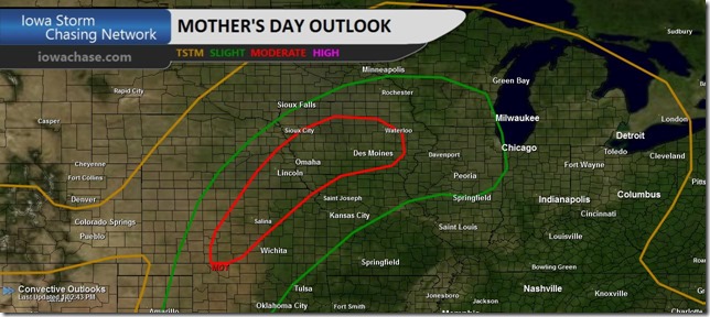
Officials with the Iowa Storm Chasing Network say “Of particular concern here in Iowa is the conditions which will favor the development of a few, independent supercells, rather than a more linear bowing structure of storms. This setup gives us concern that not only are tornadoes possible, but strong, long-track tornadoes as well.”
Here’s the weather forecast for Atlantic and the KJAN listening area, and weather information for Atlantic.

Podcast: Play in new window | Download (1.0MB)
Subscribe: RSS
AREA COUNTIES: SAC-CRAWFORD-CARROLL-AUDUBON-GUTHRIE-DALLAS-CASS-ADAIR-MADISON-ADAMS-UNION-TAYLOR-RINGGOLD
455 AM CDT SAT MAY 10 2014
TODAY AND TONIGHT:
A SLIGHT RISK OF SEVERE THUNDERSTORMS IS FORECAST OVER SOUTHERN IOWA…GENERALLY ALONG AND SOUTH OF HIGHWAY 34…THIS AFTERNOON AND EVENING. LARGE HAIL AND DAMAGING WINDS ARE THE MAIN THREAT. ISOLATED STRONG TO POTENTIALLY SEVERE THUNDERSTORMS LOOK POSSIBLE NORTH OF HIGHWAY 34…WHERE HAIL AND WINDS REMAIN A THREAT.
SUNDAY:
THE PROBABILITY FOR WIDESPREAD SEVERE THUNDERSTORMS IS INCREASING SUNDAY INTO SUNDAY EVENING. LARGE HAIL AND ISOLATED TORNADOES WILL BE POSSIBLE OVER MUCH OF CENTRAL IOWA. HEAVY RAIN IS ALSO ANTICIPATED SUNDAY AFTERNOON THROUGH MONDAY AND MAY LEAD TO LOCALIZED AREAS OF FLASH FLOODING.
SPOTTER INFORMATION STATEMENT…
SPOTTER ACTIVATION IS POSSIBLE THIS AFTERNOON AND EVENING…AND WILL LIKELY BE NEEDED SUNDAY INTO SUNDAY NIGHT…AND AGAIN ON MONDAY.
AREA COUNTIES: MONONA-HARRISON-SHELBY-POTTAWATTAMIE-MILLS-MONTGOMERY-FREMONT-PAGE…-
511 AM CDT SAT MAY 10 2014
TODAY AND TONIGHT:
ISOLATED THUNDERSTORMS WILL BE POSSIBLE TODAY…MAINLY LATER THIS
MORNING AND AFTERNOON. WHILE STORMS WOULD REMAIN BELOW SEVERE
LEVELS THIS MORNING…THERE IS A SLIGHT RISK OF SEVERE STORMS
ACROSS SOUTHWESTERN IOWA THIS AFTERNOON SOUTH OF INTERSTATE 80.
AFTER A BREAK THIS EVENING…ADDITIONAL THUNDERSTORMS ARE EXPECTED
TO DEVELOP AFTER MIDNIGHT IN SOUTHEAST NEBRASKA…SPREADING NORTH
ACROSS THE AREA THROUGH DAYBREAK. SOME OF THESE STORMS COULD BE
STRONG TO SEVERE WITH LARGE HAIL THE PRIMARY HAZARD ACROSS SOUTHEAST
NEBRASKA AND SOUTHWEST IOWA…ALONG AND SOUTH OF INTERSTATE 80.
SUNDAY …
SCATTERED STRONG THUNDERSTORMS MAY BE ONGOING SUNDAY MORNING
ACROSS SOUTHEAST NEBRASKA AND SOUTHWEST IOWA WITH LARGE HAIL
POSSIBLE…AS A WARM FRONT LIFTS NORTH INTO THE REGION. ADDITIONAL
STRONG TO SEVERE STORMS ARE EXPECTED TO DEVELOP ALONG THE FRONT
DURING THE AFTERNOON…DEVELOPING INTO A SQUALL LINE SUNDAY
EVENING THEN MOVING EAST AND OUT OF THE AREA AFTER MIDNIGHT.
SEVERE STORMS WITH ALL MODES OF SEVERE WEATHER WILL BE POSSIBLE
ALONG THE FRONT…GENERALLY ALONG AND SOUTHEAST OF A LINE FROM
ABOUT COLUMBUS NEBRASKA TO ONAWA IOWA. THIS WOULD INCLUDE SUPERCELL
STORMS WITH VERY LARGE HAIL…DAMAGING WINDS AND ISOLATED TORNADOES.
LOCALLY HEAVY RAINFALL WILL ALSO ACCOMPANY THE THUNDERSTORMS AS
THEY PUSH THROUGH THE REGION LATE SUNDAY AFTERNOON AND EVENING.
.SPOTTER INFORMATION STATEMENT…
SPOTTER ACTIVATION SHOULD NOT BE NEEDED TODAY OR TONIGHT…BUT
COULD BE NEEDED SUNDAY IN SOUTHEAST NEBRASKA AND SOUTHWEST IOWA.


