
Today: Sunny, with a high near 88. Southwest wind 5 to 7 mph.
Tonight: Mostly clear, with a low around 63. West southwest wind around 6 mph becoming light and variable.
Tomorrow: Sunny, with a high near 88. North northeast wind 5 to 7 mph.
Tom. Night: A 20 percent chance of showers and thunderstorms after 1am. Partly cloudy, with a low around 64. North northeast wind around 6 mph becoming southeast after midnight.
Sunday: A chance of showers and thunderstorms, then showers likely and possibly a thunderstorm after 1pm. Partly sunny, with a high near 82. Chance of precipitation is 70%. New rainfall amounts between a quarter and half of an inch possible.
Sunday Night: A 40 percent chance of showers and thunderstorms before 1am. Partly cloudy, with a low around 58. Breezy.
Monday: Sunny, with a high near 76. Breezy.
Thursday’s High in Atlantic was 83 and our low was 57. We received .15″ rain last night. This day last year the high in Atlantic was 91 and the low was 57. The all-time record High on Aug. 11th was 104 in 1894 and the record low was 40 in 1902. Sunrise is at 6:24 and sunset is 8:25.
(Radio Iowa) – The tree-planting program called Re-Leaf is holding a ceremony in Cedar Rapids this (Thursday) morning, marking the devastating derecho that swept across Iowa three years ago today. Winds peaked at 140 miles an hour and it was the most costly storm in U-S history. Cedar Rapids was especially hard hit, losing two-thirds of its canopy — or some 670-thousand trees. In this interview from August of 2020, state climatologist Justin Glisan said the storm started in southern South Dakota.
“The derecho itself held together for 770 miles over 14 hours before losing strength as it entered western Ohio,” Glisan says. Many Iowans had never even heard the term “derecho” before the powerful storm blasted across the state’s midsection, wiping out trees, power lines and crops. Three Iowans were killed, many were hurt. To be designated as a derecho, a storm must have a width of at least 60 miles and travel at least 400 miles. In this file interview, Dennis Todey, director of the U-S-D-A’s Midwest Climate Hub in Ames, said derechos are hard to predict. 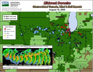
“Unfortunately, we can’t forecast these things too well in advance,” Todey says, “but once it set up and it was starting to look consistent, the Weather Service was right on top of it then and was doing warnings well ahead of it, letting people know this was a pretty nasty situation and had the potential for doing severe damage, which it did.” More than a half-million Iowa homes and businesses lost power during the storm, easily among the worst weather disasters for the state’s electric utilities. The governor declared 20 counties disaster areas. Todey says a derecho is very atypical to the storms Iowans are used to seeing during the summer months.

NWS photo near Shellsburg, August 10, 2020
“Unlike some thunderstorms which build up, rain out and then the cold air that spreads out from that shuts down the instability around a storm, this one is able to feed on itself,” Todey says. “The wind coming out ahead of it is able to lift warmer, moister air ahead of it and that keeps feeding back on that storm and maintain its strength all the way through.”
Derecho is a Spanish word that can be translated as direct or straight ahead. It was first coined by Dr. Gustavus Hinrichs at the University of Iowa in the late 1800s. Hinrichs, who started the first state weather service, is also among the researchers credited with the discovery of the atom and the Periodic Table of Elements.
Today: Areas of fog before 8am. Otherwise, mostly sunny, with a high near 84. Calm wind becoming south southwest 5 to 9 mph in the afternoon.
Tonight: A 40 percent chance of showers and thunderstorms, mainly between 10pm and 4am. Mostly cloudy, then gradually becoming mostly clear, with a low around 65. South wind 7 to 9 mph. New rainfall amounts between a tenth and quarter of an inch, except higher amounts possible in thunderstorms.
Friday: Sunny, with a high near 88. Southwest wind around 7 mph.
Saturday: Sunny, with a high near 86.
Sunday: Showers and possibly a thunderstorm. High near 80. Chance of precipitation is 80%.
Wednesday’s High in Atlantic was 81 and our low this morning, was 57. This day last year the high in Atlantic was 92 and the low was 56. The all-time record High on Aug. 10th was 105 in 1894 and the record low was 42 in 1967. Sunrise is at 6:23 and sunset is 8:27.
(Radio Iowa) – As we endure the sweltering sun of summer, Iowans may find some relief in pondering the cooler weather that’s sure to come. The new edition of the Farmers’ Almanac is now available and managing editor Sandi Duncan says they’re predicting plenty of cold and widespread snow for the Great Plains states, including Iowa. “The 2024 Farmers’ Almanac says, ‘The BRR is Back,’ meaning that there’s going to be a lot of cold temperatures coming to your neck of the woods this winter season,” Duncan says. “Overall, we’re thinking that it’s going to be ultimately more of a cold than a snowy winter, but we do see some occasional bouts of storminess bringing widespread rain and snow to your region.”
The publication is forecasting a more traditional winter ahead, with colder temperatures and near-countrywide snowfall. As for Iowa, it may arrive sooner, not later. “Winter is going to start a little bit early. It looks like in December, the Farmers’ Almanac is calling for some snowy conditions,” Duncan says. “Some people like to have a little bit of white around the Christmas holidays so that may happen, but looking into January and February, the cold is more the headliner this winter.”
After wintertime is technically over, the almanac is calling for what it calls a “Polar Coaster Spring,” which doesn’t sound like something that will enthuse Iowa farmers — or many of the rest of us. “It’s kind of going to go back and forth and in fact, winter is going to hang on,” Duncan says. “We’re calling for some cool and cold conditions through March and into April. So even though the calendar may say spring, it looks like it’s going to be kind of a Polar Coaster, meaning that we see nice days that remind you that spring is coming, but overall, we see a kind of a chilly, rainy season on tap for you all.”
In a Radio Iowa interview in August of 2022, the almanac’s editors predicted we’d have a “glacial, snow-filled” winter, with heavy snows beginning in late October. How did that forecast compare to what Iowa actually saw? “Cold weather kind of got stuck over Russia and China, so of course, you had some cold conditions, but our forecast was slightly off the mark,” Duncan says, “but you know, we do our best. We try to give people an idea of what may come 12 months to 16 months down the road so that you can plan ahead.”
The Lewiston, Maine-based almanac was founded in 1818 and boasts a forecast accuracy rate of 80- to 85-percent. The formula was developed more than two centuries ago, based on factors including sunspot activity, planet positions, and the effect the Moon has on the Earth. Besides long-term weather predictions, the Farmers’ Almanac also contains a wealth of information on gardening, cooking, home remedies, folklore, managing your household, living in harmony with nature, and more.
Today: Showers and thunderstorms likely, mainly before 11am. Mostly cloudy, with a high near 75. Light and variable wind becoming south southeast 5 to 7 mph in the morning. Chance of precipitation is 60%. New rainfall amounts between a tenth and quarter of an inch, except higher amounts possible in thunderstorms.
Tonight: Partly cloudy, with a low around 59. North northeast wind around 6 mph becoming light and variable in the evening.
Tomorrow: Mostly sunny, with a high near 82. South southwest wind 3 to 7 mph.
Tom. Night: A 30 percent chance of showers and thunderstorms after 1am. Partly cloudy, with a low around 64. South wind 9 to 14 mph, with gusts as high as 22 mph. New rainfall amounts between a tenth and quarter of an inch, except higher amounts possible in thunderstorms.
Friday: A chance of showers and thunderstorms before 1pm, then a chance of showers between 1pm and 4pm, then a chance of showers and thunderstorms after 4pm. Sunny, with a high near 86. Chance of precipitation is 30%. New rainfall amounts of less than a tenth of an inch, except higher amounts possible in thunderstorms.
Friday Night: A slight chance of thunderstorms before 7pm. Mostly clear, with a low around 64. Chance of precipitation is 10%.
Saturday: Sunny, with a high near 85.
Tuesday’s High in Atlantic was 83 and the low was 63. We received .34″ of rain overnight at the KJAN studios. This day last year the high in Atlantic was 87 and the low was 56. The all-time record High on Aug. 9th was 111 in 1934 and the record low was 44 in 1927. Sunrise is at 6:22 and sunset is 8:28.
Today: Patchy fog before 8am. Otherwise, mostly sunny, with a high near 79. Calm wind becoming west southwest 5 to 7 mph in the afternoon.
Tonight: A chance of showers and thunderstorms, then showers likely and possibly a thunderstorm after 5am. Mostly cloudy, with a low around 62. Southeast wind 3 to 5 mph. Chance of precipitation is 60%. New rainfall amounts of less than a tenth of an inch, except higher amounts possible in thunderstorms.
Wednesday: Showers and possibly a thunderstorm before noon, then a chance of showers and thunderstorms, mainly between noon and 5pm. High near 77. Southeast wind 5 to 7 mph becoming north northwest in the afternoon. Chance of precipitation is 90%. New rainfall amounts between a quarter and half of an inch possible.
Thursday: Mostly sunny, with a high near 82.
Friday: A 30 percent chance of showers. Mostly sunny, with a high near 86. Breezy.
Monday’s High in Atlantic was 81 and the low was 60. This day last year the high in Atlantic was 80 and the low was 52. The all-time record High on Aug. 8th was 111 in 1934 and the record low was 39 in 1904. Sunrise is at 6:21 a.m. and sunset is 8:29 p.m.
(Radio Iowa) – Governor Reynolds has issued disaster proclamations for Lee and Sioux Counties for severe weather that struck on Friday and Saturday. Heavy rain fell in Sioux County on Friday and Saturday. The National Weather Service reports rainfall amounts of seven-and-a-half to more than nine inches in the Sioux Center area. According to the National Weather Service in the Quad Cities, heavy rain fell in southeast Iowa Saturday. Between four and eight inches of rain fell in less than six hours, causing flash flooding and several water rescues in Keokuk. W-G-E-M T-V received an unofficial report from the Keokuk area of 11 inches of rain on Saturday.
The governor’s emergency declaration activates the state’s individual assistance grant program for low-income households. Grants of up to five-thousand dollars are available to cover home or car repairs and replace food or clothing. The grants can also cover the cost of temporary housing.
Today: Partly sunny, with a high near 78. North northwest wind around 9 mph.
Tonight: Partly cloudy, with a low around 60. Northwest wind 5 to 7 mph becoming calm in the evening.
Tuesday: A 20 percent chance of showers and thunderstorms. Partly sunny, with a high near 78. Light and variable wind becoming southwest 5 to 8 mph in the morning.
Tuesday Night: A slight chance of showers and thunderstorms, then showers likely and possibly a thunderstorm after 1am. Mostly cloudy, with a low around 62. East southeast wind 5 to 7 mph. Chance of precipitation is 60%. New rainfall amounts between a quarter and half of an inch possible.
Wednesday: Showers likely and possibly a thunderstorm before 1pm, then a chance of showers and thunderstorms after 1pm. Mostly cloudy, with a high near 75. Chance of precipitation is 70%. New rainfall amounts between three quarters and one inch possible.
Thursday: Mostly sunny, with a high near 82.
Sunday’s High in Atlantic was 74 and the low was 64. We received .19″ inch of rain at the KJAN studios. This day last year the high in Atlantic was 93 and the low was 66. The all-time record High on Aug. 7th was 103 in 1937 and the record low was 45 set in 1989. Sunrise is at 6:20 a.m. and sunset is 8:31 p.m.


