
1150 AM CDT MON JUN 30 2014
THE NATIONAL WEATHER SERVICE IN OMAHA HAS ISSUED A
* SEVERE THUNDERSTORM WARNING FOR…
NORTHEASTERN POTTAWATTAMIE COUNTY IN SOUTHWEST IOWA…
* UNTIL 1215 PM CDT
* AT 1149 AM CDT…A SEVERE THUNDERSTORM WAS LOCATED NEAR AVOCA…OR
15 MILES WEST OF ATLANTIC…MOVING EAST AT 35 MPH.
HAZARD…60 MPH WIND GUSTS AND HALF DOLLAR SIZE HAIL.
SOURCE…RADAR INDICATED.
IMPACT…HAIL DAMAGE TO VEHICLES IS EXPECTED. EXPECT WIND DAMAGE
TO ROOFS…SIDING AND TREES.
* LOCATIONS IMPACTED INCLUDE…
AVOCA…WALNUT…HANCOCK AND BOTNA BEND PARK.
THIS INCLUDES THE FOLLOWING HIGHWAYS…
HIGHWAY 59 IN IOWA BETWEEN MILE MARKERS 55 AND 66.
INTERSTATE 80 IN IOWA BETWEEN MILE MARKERS 40 AND 48.
PRECAUTIONARY/PREPAREDNESS ACTIONS…
FOR YOUR PROTECTION MOVE TO AN INTERIOR ROOM ON THE LOWEST FLOOR OF A
BUILDING.
1148 AM CDT MON JUN 30 2014
THE NATIONAL WEATHER SERVICE IN DES MOINES HAS ISSUED A
* SEVERE THUNDERSTORM WARNING FOR…
AUDUBON COUNTY IN WEST CENTRAL IOWA…
GUTHRIE COUNTY IN WEST CENTRAL IOWA…
* UNTIL 1230 PM CDT
* AT 1148 AM CDT…A SEVERE THUNDERSTORM WAS LOCATED 5 MILES
SOUTHEAST OF IRWIN…OR 10 MILES WEST OF AUDUBON…MOVING EAST AT
65 MPH.
HAZARD…PING PONG BALL SIZE HAIL AND 60 MPH WIND GUSTS.
SOURCE…RADAR INDICATED.
IMPACT…PEOPLE AND ANIMALS OUTDOORS WILL BE INJURED. EXPECT HAIL
DAMAGE TO ROOFS…SIDING…WINDOWS AND VEHICLES. EXPECT
WIND DAMAGE TO ROOFS…SIDING AND TREES.
* LOCATIONS IMPACTED INCLUDE…
AUDUBON…GUTHRIE CENTER…PANORA…LAKE PANORAMA…EXIRA…ELK
HORN…BAYARD…KIMBALLTON…BAGLEY…YALE…JAMAICA…LINDEN…
BRAYTON…GRAY…LAKIN SLOUGH GAME MANAGEMENT AREA…AUDUBON COUNTY
AIRPORT AND SPRINGBROOK STATE PARK.
PRECAUTIONARY/PREPAREDNESS ACTIONS…
FOR YOUR PROTECTION MOVE TO AN INTERIOR ROOM ON THE LOWEST FLOOR OF A
BUILDING.
1136 AM CDT MON JUN 30 2014
THE NATIONAL WEATHER SERVICE IN OMAHA HAS ISSUED A
* SEVERE THUNDERSTORM WARNING FOR…
SHELBY COUNTY IN SOUTHWEST IOWA…
* UNTIL 1215 PM CDT
* AT 1135 AM CDT…A SEVERE THUNDERSTORM WAS LOCATED NEAR HARLAN…OR
26 MILES SOUTH OF DENISON…MOVING EAST AT 35 MPH.
HAZARD…60 MPH WIND GUSTS AND HALF DOLLAR SIZE HAIL.
SOURCE…RADAR INDICATED.
IMPACT…HAIL DAMAGE TO VEHICLES IS EXPECTED. EXPECT WIND DAMAGE
TO ROOFS…SIDING AND TREES.
* LOCATIONS IMPACTED INCLUDE…
HARLAN…ELK HORN…SHELBY…EARLING…IRWIN…PANAMA…
PORTSMOUTH…WESTPHALIA…TENNANT…KIRKMAN…NISHNA BEND
RECREATION AREA…PRAIRIE ROSE STATE PARK AND ELK HORN CREEK
RECREATION AREA.
THIS INCLUDES HIGHWAY 59 IN IOWA BETWEEN MILE MARKERS 67 AND 86.
PRECAUTIONARY/PREPAREDNESS ACTIONS…
FOR YOUR PROTECTION MOVE TO AN INTERIOR ROOM ON THE LOWEST FLOOR OF A
BUILDING.
1104 AM CDT MON JUN 30 2014
THE NATIONAL WEATHER SERVICE IN OMAHA HAS ISSUED A
* FLASH FLOOD WARNING FOR…
NORTHWESTERN HARRISON COUNTY IN SOUTHWEST IOWA…
MONONA COUNTY IN WEST CENTRAL IOWA…
BURT COUNTY IN EAST CENTRAL NEBRASKA…
EASTERN THURSTON COUNTY IN NORTHEAST NEBRASKA…
* UNTIL 200 PM CDT
* AT 1101 AM CDT…DOPPLER RADAR INDICATED A LINE OF THUNDERSTORMS
PRODUCING HEAVY RAIN MOVING THROUGH THROUGH MONONA COUNTY…WITH
HEAVY RAIN EXTENDING 30 MILES TO THE WEST. FLASH FLOODING IS
EXPECTED TO BEGIN SHORTLY.
* SOME LOCATIONS THAT WILL EXPERIENCE FLOODING INCLUDE…
ONAWA…LYONS…WHITING…DECATUR…UTE…PISGAH…MOORHEAD…
CRAIG…MACY…OAKLAND…MAPLETON…DUNLAP…BLENCOE…SOLDIER…
LITTLE SIOUX…CASTANA…TURIN…RODNEY…PELICAN POINT STATE
RECREATION AREA AND LEWIS AND CLARK STATE PARK.
ADDITIONAL RAINFALL AMOUNTS OF 2 TO 3 INCHES ARE POSSIBLE.
PRECAUTIONARY/PREPAREDNESS ACTIONS…
MOVE TO HIGHER GROUND NOW. STREETS AND SMALL STREAMS WILL FLOOD
QUICKLY. DO NOT DRIVE THROUGH WATER COVERING THE ROAD.
NATIONAL WEATHER SERVICE OMAHA/VALLEY NEBRASKA
1110 AM CDT MON JUN 30 2014
THE NATIONAL WEATHER SERVICE IN OMAHA HAS ISSUED A
* SEVERE THUNDERSTORM WARNING FOR…
WESTERN SHELBY COUNTY IN SOUTHWEST IOWA…
HARRISON COUNTY IN SOUTHWEST IOWA…
EASTERN MONONA COUNTY IN WEST CENTRAL IOWA…
SOUTHEASTERN BURT COUNTY IN EAST CENTRAL NEBRASKA…
* UNTIL 1215 PM CDT
* AT 1110 AM CDT…SEVERE THUNDERSTORMS WERE LOCATED ALONG A LINE
EXTENDING FROM NEAR DANBURY TO NEAR MONDAMIN…MOVING EAST AT 65
MPH.
HAZARD…60 MPH WIND GUSTS AND QUARTER SIZE HAIL.
SOURCE…RADAR INDICATED.
IMPACT…HAIL DAMAGE TO VEHICLES IS EXPECTED. EXPECT WIND DAMAGE
TO ROOFS…SIDING AND TREES.
* LOCATIONS IMPACTED INCLUDE…
HARLAN…LOGAN…EARLING…MONDAMIN…UTE…PERSIA…DEFIANCE…
PISGAH…MOORHEAD…WOODBINE…MAPLETON…DUNLAP…BLENCOE…
PANAMA…PORTSMOUTH…MAGNOLIA…SOLDIER…LITTLE SIOUX…CASTANA
AND WESTPHALIA.
THIS INCLUDES THE FOLLOWING HIGHWAYS…
HIGHWAY 59 IN IOWA BETWEEN MILE MARKERS 80 AND 89.
HIGHWAY 75 IN NEBRASKA NEAR MILE MARKER 129.
INTERSTATE 29 BETWEEN MILE MARKERS 84 AND 101.
PRECAUTIONARY/PREPAREDNESS ACTIONS…
FOR YOUR PROTECTION MOVE TO AN INTERIOR ROOM ON THE LOWEST FLOOR OF A
BUILDING.
Officials with the National Service in Des Moines are warning Iowans to be prepared “For all modes of severe weather” across the state today. In their mid-morning web briefing, the Weather Service said tornadoes, large hail and damaging winds have occurred and can be expected to continue. The best threat for severe weather will be across the southern two-thirds of the state, with “Multiple waves” of severe weather possible.
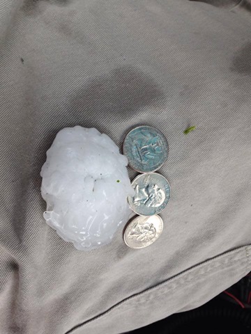
3″ diameter hail in Harlan this morning. (Shelby County EMA photo)
In addition, heavy rainfall with areas of localized flooding is possible from mid-day through tonight. There is a 10-percent or greater chance of tornadoes today across western and central Iowa. The tornadoes may rate from EF-2 or higher on the Fujita scale, meaning winds could be well in excess of 115-miles per hour. An EF-2 tornado can cause considerable damage, with roofs torn off frame houses; mobile homes demolished; boxcars overturned; large trees snapped or uprooted; light-object missiles generated; cars lifted off ground.
The greatest damaging wind threat will be over central and eastern Iowa. Most of central and western Iowa will also be impacted by large, damaging hail today. Stay tuned to KJAN for continued weather coverage.
1037 AM CDT MON JUN 30 2014
THE NATIONAL WEATHER SERVICE IN OMAHA HAS ISSUED A
* SEVERE THUNDERSTORM WARNING FOR…
NORTHWESTERN HARRISON COUNTY IN SOUTHWEST IOWA…
MONONA COUNTY IN WEST CENTRAL IOWA…
BURT COUNTY IN EAST CENTRAL NEBRASKA…
SOUTHEASTERN CUMING COUNTY IN NORTHEAST NEBRASKA…
EASTERN THURSTON COUNTY IN NORTHEAST NEBRASKA…
* UNTIL 1130 AM CDT
* AT 1036 AM CDT…SEVERE THUNDERSTORMS WERE LOCATED ALONG A LINE
EXTENDING FROM NEAR SALIX TO NEAR SNYDER…MOVING EAST AT 50 MPH.
HAZARD…70 MPH WIND GUSTS AND HALF DOLLAR SIZE HAIL.
SOURCE…RADAR INDICATED.
IMPACT…HAIL DAMAGE TO VEHICLES IS EXPECTED. EXPECT CONSIDERABLE
TREE DAMAGE. WIND DAMAGE IS ALSO LIKELY TO MOBILE
HOMES…ROOFS AND OUTBUILDINGS.
* LOCATIONS IMPACTED INCLUDE…
ONAWA…TEKAMAH…LYONS…WHITING…BANCROFT…DECATUR…CRAIG…
MACY…OAKLAND…MAPLETON…BLENCOE…LITTLE SIOUX…ROSALIE…
CASTANA…TURIN…RODNEY…PELICAN POINT STATE RECREATION AREA…
SUMMIT LAKE STATE RECREATION AREA…LEWIS AND CLARK STATE PARK AND
KENNEBEC.
THIS INCLUDES THE FOLLOWING HIGHWAYS…
HIGHWAY 275 IN NEBRASKA BETWEEN MILE MARKERS 123 AND 124.
HIGHWAY 75 IN NEBRASKA BETWEEN MILE MARKERS 129 AND 165.
HIGHWAY 77 IN NEBRASKA BETWEEN MILEMARKERS 136 AND 164.
INTERSTATE 29 BETWEEN MILE MARKERS 92 AND 125.
PRECAUTIONARY/PREPAREDNESS ACTIONS…
PREPARE IMMEDIATELY FOR LARGE HAIL AND DAMAGING WINDS. PEOPLE OUTSIDE
SHOULD MOVE TO A SHELTER…INSIDE A STRONG BUILDING AND AWAY FROM
WINDOWS.
1013 AM CDT MON JUN 30 2014
THE NATIONAL WEATHER SERVICE IN DES MOINES HAS ISSUED A
* SEVERE THUNDERSTORM WARNING FOR…
AUDUBON COUNTY IN WEST CENTRAL IOWA…
WESTERN DALLAS COUNTY IN CENTRAL IOWA…
GUTHRIE COUNTY IN WEST CENTRAL IOWA…
* UNTIL 1115 AM CDT
* AT 1013 AM CDT…A SEVERE THUNDERSTORM WAS LOCATED 5 MILES
SOUTHEAST OF AUDUBON…MOVING EAST AT 35 MPH.
HAZARD…GOLF BALL SIZE HAIL AND 60 MPH WIND GUSTS.
SOURCE…RADAR INDICATED.
IMPACT…PEOPLE AND ANIMALS OUTDOORS WILL BE INJURED. EXPECT HAIL
DAMAGE TO ROOFS…SIDING…WINDOWS AND VEHICLES. EXPECT
WIND DAMAGE TO ROOFS…SIDING AND TREES.
* LOCATIONS IMPACTED INCLUDE…
AUDUBON…GUTHRIE CENTER…STUART…PANORA…LAKE PANORAMA…
EXIRA…DEXTER…CASEY…DIAMONDHEAD LAKE…MENLO…BAGLEY…
YALE…JAMAICA…LINDEN…BRAYTON…LAKIN SLOUGH GAME MANAGEMENT
AREA…AUDUBON COUNTY AIRPORT AND SPRINGBROOK STATE PARK.
PRECAUTIONARY/PREPAREDNESS ACTIONS…
FOR YOUR PROTECTION MOVE TO AN INTERIOR ROOM ON THE LOWEST FLOOR OF A
BUILDING.
THIS IS A DANGEROUS STORM. PREPARE IMMEDIATELY FOR LARGE DESTRUCTIVE
HAIL CAPABLE OF PRODUCING SIGNIFICANT DAMAGE. PEOPLE OUTSIDE SHOULD
MOVE TO A SHELTER…INSIDE A STRONG BUILDING AND AWAY FROM WINDOWS.
944 AM CDT MON JUN 30 2014
…A SEVERE THUNDERSTORM WARNING REMAINS IN EFFECT UNTIL 1015 AM CDT
FOR AUDUBON AND GUTHRIE COUNTIES…
AT 944 AM CDT…A SEVERE THUNDERSTORM WAS LOCATED 8 MILES EAST OF
HARLAN…OR 14 MILES SOUTHWEST OF AUDUBON…MOVING EAST AT 25 MPH.
HAZARD…TENNIS BALL SIZE HAIL AND 60 MPH WIND GUSTS.
SOURCE…RADAR INDICATED.
IMPACT…PEOPLE AND ANIMALS OUTDOORS WILL BE INJURED. EXPECT HAIL
DAMAGE TO ROOFS…SIDING…WINDOWS AND VEHICLES. EXPECT
WIND DAMAGE TO ROOFS…SIDING AND TREES.
LOCATIONS IMPACTED INCLUDE…
AUDUBON…GUTHRIE CENTER…PANORA…LAKE PANORAMA…EXIRA…ELK
HORN…KIMBALLTON…BAGLEY…YALE…BRAYTON…AUDUBON COUNTY AIRPORT
AND SPRINGBROOK STATE PARK.
PRECAUTIONARY/PREPAREDNESS ACTIONS…
THIS STORM IS PRODUCING LARGE HAIL. SEEK SHELTER NOW INSIDE A STURDY
STRUCTURE AND STAY AWAY FROM WINDOWS.
THIS IS A DANGEROUS STORM. PREPARE IMMEDIATELY FOR LARGE DESTRUCTIVE
HAIL CAPABLE OF PRODUCING SIGNIFICANT DAMAGE. PEOPLE OUTSIDE SHOULD
MOVE TO A SHELTER…INSIDE A STRONG BUILDING AND AWAY FROM WINDOWS.
935 AM CDT MON JUN 30 2014
THE NWS STORM PREDICTION CENTER HAS ISSUED A
* TORNADO WATCH FOR PORTIONS OF WESTERN AND CENTRAL IOWA & EASTERN NEBRASKA
* EFFECTIVE THIS MONDAY MORNING AND EVENING FROM 935 AM UNTIL 600 PM CDT.
* PRIMARY THREATS INCLUDE…
A FEW TORNADOES LIKELY WITH A COUPLE INTENSE TORNADOES POSSIBLE WIDESPREAD LARGE HAIL EXPECTED WITH ISOLATED VERY LARGE HAIL EVENTS TO 3 INCHES IN DIAMETER POSSIBLE WIDESPREAD DAMAGING WINDS LIKELY WITH ISOLATED SIGNIFICANT GUSTS
TO 80 MPH POSSIBLE.
THE TORNADO WATCH AREA IS APPROXIMATELY ALONG AND 55 STATUTE MILES NORTH AND SOUTH OF A LINE FROM 50 MILES WEST NORTHWEST OF COLUMBUS NEBRASKA TO 15 MILES NORTH NORTHEAST OF OTTUMWA IOWA.
PRECAUTIONARY/PREPAREDNESS ACTIONS…
REMEMBER…A TORNADO WATCH MEANS CONDITIONS ARE FAVORABLE FOR TORNADOES AND SEVERE THUNDERSTORMS IN AND CLOSE TO THE WATCH AREA. PERSONS IN THESE AREAS SHOULD BE ON THE LOOKOUT FOR THREATENING WEATHER CONDITIONS AND LISTEN FOR LATER STATEMENTS AND POSSIBLE WARNINGS.
COUNTIES INCLUDED IN THE WATCH:
ADAIR ADAMS APPANOOSE AUDUBON BOONE CALHOUN CARROLL CASS CLARKE CRAWFORD DALLAS DAVIS DECATUR FREMONT GREENE GRUNDY GUTHRIE HAMILTON HARDIN HARRISON JASPER LUCAS MADISON MAHASKA MARION MARSHALL MILLS MONONA MONROE MONTGOMERY PAGE POLK POTTAWATTAMIE POWESHIEK RINGGOLD SAC SHELBY STORY TAMA
TAYLOR UNION WAPELLO WARREN WAYNE WEBSTER.


