
Today: Sunny, with a high near 80. Windy, with a northwest wind 9 to 14 mph increasing to 17 to 22 mph in the afternoon. Winds could gust as high as 31 mph.
Tonight: Mostly clear, with a low around 55. North northwest wind 6 to 14 mph.
Monday: Mostly sunny, with a high near 76. North northwest wind 6 to 10 mph.
Monday Night: Mostly clear, with a low around 55. North wind 3 to 8 mph.
Tuesday: Sunny, with a high near 79. Northwest wind 3 to 7 mph.
Tuesday Night: Mostly clear, with a low around 56.
Wednesday: Mostly sunny, with a high near 79.
(Updated 3-p.m.)
The storm prediction center has updated the severe weather outlook for Iowa today. Slight risk for severe weather across southern Iowa this afternoon and tonight.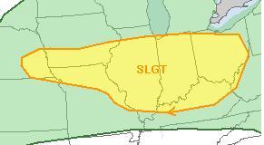 Large hail and damaging winds remain the main threat, though isolated tornadoes will be possible. Be sure to remain weather aware throughout the day!
239 PM CDT SAT JUL 26 2014
THE NATIONAL WEATHER SERVICE HAS CANCELLED SEVERE THUNDERSTORM WATCH 441 FOR THE FOLLOWING IOWA COUNTY: HARRISON .
SEVERE THUNDERSTORM WATCH 441…PREVIOUSLY IN EFFECT UNTIL 3 PM CDT THIS AFTERNOON…IS NOW IN EFFECT UNTIL 4 PM CDT THIS AFTERNOON FOR THE FOLLOWING AREAS
IN IOWA THIS WATCH INCLUDES 1 COUNTY: HARRISON
Currently, no other counties in western Iowa are under a Watch or warning.
THE NATIONAL WEATHER SERVICE HAS EXTENDED SEVERE THUNDERSTORM
WATCH 441 TO INCLUDE THE FOLLOWING AREAS UNTIL 3 PM CDT THIS AFTERNOON:
IN SOUTHWEST IOWA…HARRISON.
SEVERE THUNDERSTORM WATCH 441 REMAINS VALID UNTIL 3 PM CDT THIS AFTERNOON FOR THE FOLLOWING AREAS
IN IOWA THIS WATCH INCLUDES 1 COUNTY: IN WEST CENTRAL IOWA…MONONA
The National Weather Service says people in Iowa should be prepared for severe weather, especially this afternoon and this evening. In their web briefing late this (Saturday) morning, officials said the primary threat from storms will be damaging winds and large hail, lightening, and heavy downpours of rain.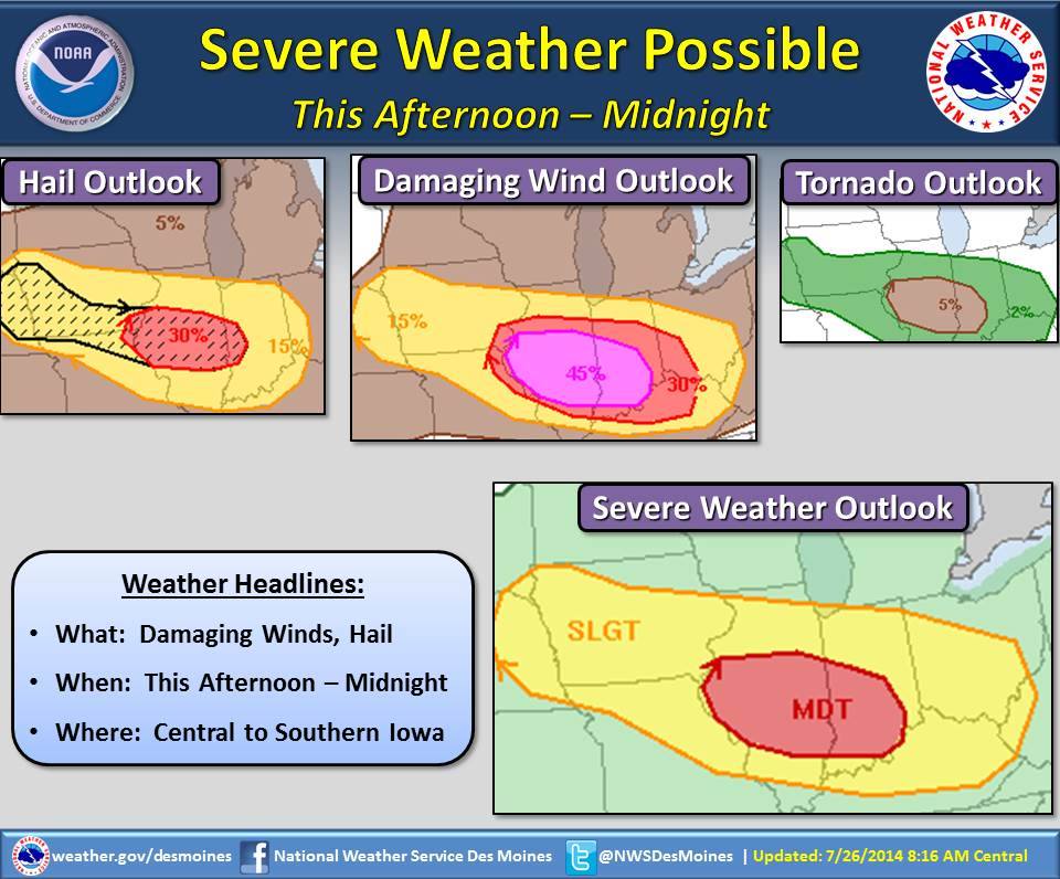
Winds of 60-to 80-miles per hour can have the same effect as an EF-0 tornado. The level of storm activity will vary widely, depending on how far north a frontal boundary that pushes north from Missouri will end up. Right now, the target is southern Iowa, but southwest and western Iowa could be affected…especially by strong winds and large hail.
Timing for these events will be this afternoon through the midnight hours. Most of the State of Iowa is under a “Slight” risk for severe weather. The greatest chance for severe weather will be in far southeast Iowa into central Illinois. Stay tuned to KJAN for further weather updates.
456 AM CDT SAT JUL 26 2014
AREAS COUNTIES: SAC-CRAWFORD-CARROLL-AUDUBON-GUTHRIE-DALLAS-CASS-ADAIR-MADISON-ADAMS-UNION–
…PATCHY DENSE FOG DEVELOPING ACROSS THE AREA THIS MORNING…
LOCALIZED AREAS OF DENSE FOG HAVE DEVELOPED AND WILL CONTINUE THROUGH 7 AM CDT THIS MORNING. VISIBILITY OF ONE TO TWO MILES WILL BE COMMON OVER MUCH OF THE REGION EARLY TODAY…BUT LOCALIZED AREAS WILL EXPERIENCE VISIBILITIES OF ONE QUARTER MILE OR LESS AT TIMES.
DUE TO THE PATCHY NATURE OF THE DENSE FOG…IF YOU ARE TRAVELING PREPARE FOR RAPIDLY CHANGING VISIBILITIES. USE EXTRA CAUTION…AND SLOW DOWN. IF DENSE FOG IS ENCOUNTERED…BE ESPECIALLY CAUTIOUS WHEN APPROACHING INTERSECTIONS AND RAILROAD CROSSINGS AS ONCOMING TRAFFIC AND TRAINS MAY BE HIDDEN BY THE DENSE FOG.
COUNTIES: GUTHRIE-DALLAS-CASS-ADAIR-MADISON-ADAMS-UNION-TAYLOR- RINGGOLD–POTTAWATTAMIE-MILLS-MONTGOMERY-FREMONT-PAGE; 424 AM CDT SAT
THE NATIONAL WEATHER SERVICE’ HAZARDOUS WEATHER OUTLOOK FOR TODAY CALLS FOR A CHANCE OF THUNDERSTORMS THIS AFTERNOON AND THIS EVENING, MAINLY ALONG AND SOUTH OF INTERSTATE 80. THESE STORMS WILL MAINLY BE CAUSED BY A COMBINATION OF AN UPPER LEVEL DISTURBANCE INTERACTING WITH A FRONTAL BOUNDARY.
SOME OF THE STORMS MAY BE SEVERE…ESPECIALLY FAR SOUTH…WITH DAMAGING WIND…LARGE HAIL AND A FEW TORNADOES. LOCALLY HEAVY RAINS MAY OCCUR AS WELL WITH RAINFALL AMOUNTS OF A FEW INCHES POSSIBLE IN A SHORT TIME.
Today A slight chance of showers and thunderstorms, mainly after 3pm. Areas of fog before 8am. Otherwise, mostly sunny, with a high near 89. East northeast wind 5 to 10 mph.
Tonight A slight chance of showers and thunderstorms, mainly before 7pm. Partly cloudy, with a low around 63. Northeast wind 5 to 10 mph becoming northwest after midnight.
Sunday Sunny, with a high near 79. Breezy, with a northwest wind 5 to 15 mph, with gusts as high as 25 mph.
Sunday Night Mostly clear, with a low around 58. North northwest wind 5 to 15 mph, with gusts as high as 20 mph.
Monday Mostly sunny, with a high near 76. North wind 5 to 10 mph. Monday Night Mostly clear, with a low around 54.
Tuesday Sunny, with a high near 78.

Podcast: Play in new window | Download (676.5KB)
Subscribe: RSS
329 PM CDT FRI JUL 25 2014
CASS-ADAMS-UNION-TAYLOR-RINGGOLD-COUNTIES….
…HEAT ADVISORY IS CANCELLED…
THE NATIONAL WEATHER SERVICE IN DES MOINES HAS CANCELLED THE HEAT ADVISORY.
HEAT INDEX VALUES ACROSS THE AREA WILL CONTINUE TO BE HIGH THROUGH THE LATE AFTERNOON AND EVENING HOURS…READINGS AROUND 100 DEGREES WILL BE POSSIBLE…BUT WILL REMAIN BELOW ADVISORY CRITERIA.
MILLS-MONTGOMERY-FREMONT-PAGE COUNTIES...
…HEAT ADVISORY REMAINS IN EFFECT UNTIL 7 PM CDT THIS EVENING…
* TEMPERATURES…WILL HOLD IN THE MID TO UPPER 90S THROUGH 7 PM BEFORE FALLING INTO THE MID TO UPPER 80S BY 9 OR 10 PM.
* HEAT INDEX…THE COMBINATION OF THE HOT TEMPERATURES AND HIGH HUMIDITY VALUES WILL CREATE DANGEROUSLY HIGH HEAT INDEX VALUES OF 105 TO 110 DEGREES THROUGH 7 PM.


