
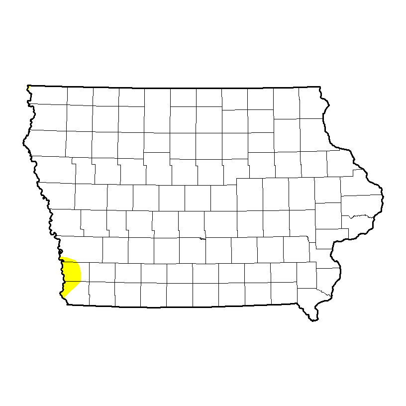
After a rainy June and a cool July, Iowa’s starting August almost entirely drought-free. A new report from the National Drought Mitigation Center finds only parts of three counties in far southwest Iowa are still in the very lowest level of drought. Center climatologist Brian Fuchs says all of those heavy downpours in June were a big benefit to Iowa, though they came at a cost. “Not only did we get the rain across the state but associated with that was the severe weather with a lot of wind, a lot of hail, even some tornadoes,” Fuchs says.
Iowa Drought map
“The recovery was influenced by these storms which also brought another form of destruction. Yeah, we put a dent in the drought but we had some suffering in other areas as well.” Governor Branstad is asking President Obama to declare 22 more Iowa counties federal disaster areas from damage sustained in storms from June 26th through July 7th. Thirty-five counties statewide have already been designated federal disaster areas for earlier storms, flooding and tornadoes. While 96 of Iowa’s 99 counties are now drought-free, the latest national picture shows drought is still very much a problem for wide sections of the country.
Fuchs says, “There has been some improvement but much of that improvement has been in the Midwest and Central Plains, the area from Nebraska and Kansas and Iowa and Missouri and Illinois where we have had the abundance of moisture but in that same period, we have seen that drought developing and expanding out in the western U.S.” Drought still plagues a large portion of the country, especially the southwestern and western United States, from California and Nevada to Texas and Oklahoma.
Fuchs says, “A little over a third of the country still is seeing some drought and a little over 10% of the country is seeing extreme drought right now.” The latest survey shows parts of three southwest Iowa counties are “abnormally dry,” the lowest category on the drought monitor: Pottawattamie, Mills and Fremont.
The Freese-Notis weather forecast and 24-hour weather data, along with a July summary for Atlantic.

Podcast: Play in new window | Download (1.1MB)
Subscribe: RSS
400 AM CDT FRI AUG 1 2014
EARLY THIS MORNING…PARTLY CLOUDY. SOUTHWEST WIND NEAR 5 MPH.
TODAY…MOSTLY SUNNY. ISOLATED THUNDERSTORMS LATE IN THE AFTERNOON. HIGH IN THE LOWER 80S. EAST WIND NEAR 5 MPH. CHANCE OF THUNDERSTORMS 20 PERCENT.
TONIGHT…PARTLY CLOUDY. LOW IN THE UPPER 50S. EAST WIND NEAR 5 MPH.
SATURDAY…MOSTLY SUNNY. HIGH IN THE LOWER 80S. SOUTHEAST WIND NEAR 5 MPH.
SATURDAY NIGHT…MOSTLY CLEAR. LOW IN THE LOWER 60S. SOUTHEAST WIND AROUND 5 MPH.
SUNDAY…MOSTLY SUNNY. HIGH IN THE MID 80S. SOUTH WIND 5 TO 10 MPH.
SUNDAY NIGHT THROUGH MONDAY NIGHT…PARTLY CLOUDY. LOW IN THE MID 60S. HIGH IN THE MID 80S.
State Climatologist Harry Hillaker says the month of July was unusually cool. “Not all the numbers are in yet, but it looks like it will probably finish up the fifth coolest July on record in Iowa and that’s among the last 142 years of data,” Hillaker says. “So fifth out of 142 is obviously pretty unusual.” In Atlantic, the Average High for the month was 78, which was eight-degrees cooler than normal. Average temperatures in July have been about four-and-a-half degrees cooler than normal.
“Which isn’t really a lot, I’d guess you’d say when you first look at it, but during the summer months we just typically don’t really have that much variability from year to year as far as summer temperatures go, so that’s pretty unusual,” Hillaker says. “Oddly enough, though, 2009 ranks as our coolest July on record, so you only have to go back five years to find a cooler one than this one.” The Average Low in Atlantic in July, was 59, which was 4 degrees below normal. Hillaker says so far, the summer of 2014 has been a “rather mild” one.
“There’s still quite a number of places over in northern and eastern Iowa that have yet to reach 90 degrees this year,” Hillaker says. “Still plenty of time for that to happen, but it hasn’t occurred yet in places like Burlington and Cedar Rapids, Mason City, Dubuque and probably a number of other places as well.” After a fairly wet June, rainfall has been sporadic and Hillaker says it’s been relatively dry for the past three to four weeks.
“Crops, for the most part, are progressing pretty well as far as seasonality, not really behind in development, so not any big negatives, I guess, on the cooler temperatures,” Hillaker says. “…We’d just like to see some more rainfall than what we’ve been getting.” In Atlantic, we received just over three-quarters of an inch of rain in July (.77”), which was slightly more than 3.9-inches below normal. Far northern Iowa is “quite a bit dry” according to Hillaker, who says the statewide average for rainfall is more than an inch below what’s normal for July.
(Radio Iowa)
Today: Sunny, with a high near 81. Calm wind becoming west southwest around 6 mph in the afternoon.
Tonight: Isolated showers and thunderstorms before 1am. Partly cloudy, with a low around 58. West southwest wind around 5 mph becoming calm in the evening. Chance of precipitation is 20%.
Friday: Isolated showers and thunderstorms after 1pm. Mostly sunny, with a high near 82. Calm wind. Chance of precipitation is 20%.
Friday Night: Partly cloudy, with a low around 58. Calm wind becoming east around 5 mph.
Saturday: Sunny, with a high near 83. Calm wind becoming east around 6 mph in the afternoon.
Saturday Night: Partly cloudy, with a low around 61.
Sunday: Sunny, with a high near 85.
The Freese-Notis forecast, and, weather information for Atlantic.
Podcast: Play in new window | Download (998.3KB)
Subscribe: RSS
345 AM CDT WED JUL 30 2014
EARLY THIS MORNING…MOSTLY CLEAR. NORTHWEST WIND NEAR 5 MPH.
TODAY…SUNNY. HIGH AROUND 80. NORTH WIND NEAR 5 MPH.
TONIGHT...MOSTLY CLEAR. LOW IN THE MID 50S. NORTH WIND NEAR 5 MPH THROUGH MIDNIGHT BECOMING LIGHT.
THURSDAY…SUNNY. HIGH IN THE LOWER 80S. NORTHWEST WIND NEAR 5 MPH.
THURSDAY NIGHT…PARTLY CLOUDY. LOW IN THE UPPER 50S. NORTHEAST WIND NEAR 5 MPH SHIFTING TO THE SOUTHEAST AFTER MIDNIGHT.
FRIDAY…MOSTLY SUNNY. HIGH IN THE LOWER 80S. SOUTHWEST WIND NEAR 5 MPH SHIFTING TO THE NORTHWEST IN THE AFTERNOON.
FRIDAY NIGHT…PARTLY CLOUDY. LOW IN THE UPPER 50S.
SATURDAY THROUGH SUNDAY NIGHT…MOSTLY CLEAR. HIGH IN THE MID 80S. LOW 59 TO 64.
Monday’s High in Atlantic was 75. Our Low this morning: 52.
Today: Mostly sunny, with a high near 80. NW @ 5-10.
Tonight: Clear to Partly cloudy, with a low around 56.
Wednesday: Sunny, with a high near 80. N @ 5.
Wed. Night: Mostly clear, with a low around 56.
Thursday: Sunny, with a high near 81. Light and variable wind.
Thu. Night: Partly cloudy, with a low around 60.
Friday: Mostly sunny, with a high near 81.
330 AM CDT TUE JUL 29 2014
EARLY THIS MORNING…MOSTLY CLEAR. NORTHWEST WIND NEAR 5 MPH.
TODAY…MOSTLY SUNNY. HIGH IN THE UPPER 70S. NORTHWEST WIND NEAR 10 MPH.
TONIGHT…PARTLY CLOUDY. LOW IN THE MID 50S. NORTH WIND NEAR 10 MPH.
WEDNESDAY…SUNNY. HIGH AROUND 80. NORTH WIND NEAR 5 MPH.
WEDNESDAY NIGHT…MOSTLY CLEAR. LOW IN THE UPPER 50S. NORTHEAST WIND NEAR 5 MPH THROUGH MIDNIGHT BECOMING LIGHT.
THURSDAY...SUNNY. HIGH IN THE LOWER 80S. SOUTHWEST WIND NEAR 5 MPH SHIFTING TO THE NORTHWEST IN THE AFTERNOON.
THURSDAY NIGHT THROUGH SUNDAY NIGHT…PARTLY CLOUDY. LOW IN THE LOWER 60S. HIGH IN THE LOWER 80S.
345 AM CDT MON JUL 28 2014
EARLY THIS MORNING…MOSTLY CLEAR. NORTHWEST WIND 5 TO 10 MPH.
TODAY...PARTLY SUNNY. ISOLATED LIGHT SHOWERS IN THE AFTERNOON. HIGH IN THE UPPER 70S. NORTH WIND 5 TO 10 MPH. CHANCE OF SHOWERS 20 PERCENT.
TONIGHT...PARTLY CLOUDY. LOW IN THE MID 50S. NORTH WIND NEAR 10 MPH.
TUESDAY...MOSTLY SUNNY. HIGH IN THE UPPER 70S. NORTHWEST WIND NEAR 5 MPH.
TUESDAY NIGHT AND WEDNESDAY…MOSTLY CLEAR. LOW IN THE MID 50S. HIGH AROUND 80. NORTH WIND NEAR 5 MPH.
WEDNESDAY NIGHT THROUGH THURSDAY NIGHT…PARTLY CLOUDY. LOW IN THE UPPER 50S. HIGH AROUND 80.
FRIDAY...MOSTLY SUNNY WITH A SLIGHT CHANCE OF SHOWERS AND ISOLATED THUNDERSTORMS. HIGH IN THE LOWER 80S. CHANCE OF PRECIPITATION 20 PERCENT.


