
Friday: Isolated showers before 8:00 am. Partly sunny, then gradually becoming sunny, with a high near 82. East northeast wind at 5 mph.
Friday Night: Clear, with a low around 55. East wind around 5 mph.
Saturday: Sunny, with a high near 83. South wind at 5 mph.
Sunday: A 50 percent chance of showers and thunderstorms. Partly sunny, with a high near 78.
Monday: A chance of showers and thunderstorms. Mostly cloudy, with a high near 71.
Today: Widespread haze before 8am. Sunny, with a high near 78. Calm wind becoming northeast 5 to 10 mph in the morning.
Tonight: A chance of showers and thunderstorms between 3:00 am and 4:00 am, then a slight chance of showers. Increasing clouds, with a low around 57. East wind around 5 mph. Chance of precipitation is 30%. New rainfall amounts of less than a tenth of an inch, except higher amounts possible in thunderstorms.
Friday: Partly sunny, then gradually becoming sunny, with a high near 83. Northeast wind around 5 mph.
Saturday: Mostly sunny, with a high near 83. South wind 5 to 10 mph.
Sunday: A chance of showers, with thunderstorms also possible after 1pm. Partly sunny, with a high near 78. Chance of precipitation is 40%.
Today: Widespread haze after 7am. Mostly cloudy, then gradually becoming sunny, with a high near 78. Breezy, with a northwest wind 15 to 20 mph, with gusts as high as 25 mph.
Tonight: Widespread haze. Mostly clear, with a low around 49. North northwest wind 5 to 10 mph.
Thursday: Sunny, with a high near 80. North northeast wind around 5 mph.
Friday: Sunny, with a high near 83. East wind around 5 mph.
Saturday: Sunny, with a high near 85.
Sunday: A 40 percent chance of showers. Partly sunny, with a high near 79.
Today: A 20 percent chance of showers and thunderstorms before 9am. Sunny, with a high near 92. Breezy, with a south wind 15 to 20 mph becoming west southwest in the afternoon. Winds could gust as high as 30 mph.
Tonight: Increasing clouds, with a low around 59. Breezy, with a west northwest wind 14 to 18 mph, with gusts as high as 29 mph.
Wednesday: Mostly sunny, with a high near 79. Breezy, with a northwest wind around 16 mph, with gusts as high as 25 mph.
Thursday: Sunny, with a high near 81.
Friday: Sunny, with a high near 83.
Monday’s High in Atlantic was 95, and the low was 56. This day last year the high was 83 and the low 56. The record high for Sept. 5th in Atlantic was 104 set in 1913 and the record low was 34 degrees set in 1962. Sunrise is at 6:50 am and sunset is at 7:47 pm.
(Radio Iowa) – State Climatologist Justin Glisan says a tornado outbreak is unlikely this month because Iowa is in a severe weather drought. “When you don’t have thunderstorms to drive rainfall, you don’t get a lot of severe weather and you get into pervasive drought,” Glisan says. So far this year in Iowa there have been 63 confirmed tornadoes.
“Four percent of the tornadoes that we see across the state of Iowa occur in September, so not a particularly high number,” Glisan says, “but recently back in 2018 we had 12 September tornadoes and then in 2019 we had nine and that’s an interesting thing to look at because 2018 was the second wettest year on record, 2019 the 10th wettest on record, so we had a very active storm track through fall.”
The mid-Atlantic and southern states are getting a lot of rain right now during hurricane season, but Glisan says those storm systems rarely bring beneficial rainfall to Iowa. “We did have a June tropical system back in 2019 that made it into eastern Iowa,” Glisan says, “and that had been the first time since 1900 that we had seen a tropical system actually make it into Iowa.” Glisan says what he calls the “moisture gate” from the Gulf of Mexico is blocked off right now, preventing the development of thunderstorms. Glisan warns, though, that tornadoes occurred in every month of the year.
“Think back to the December 15th outbreak in 2021 — 63 tornadoes across the state, the highest tornado count for any month in the state of Iowa,” Glisan says, “but also the highest tornado outbreak for a December outbreak in United States history.”
Today (Labor Day): Sunny & breezy. High near 93. South wind at 5-15 mph w/gusts to around 25
Tonight: Partly cloudy w/a slight chance of showers and thunderstorms after midnight. Low around 73. S @ 15-30 mph.
Tuesday: Mostly sunny w/a slight chance of showers and thunderstorms. High near 93. S/SW winds @ 15-25 mph
Wednesday: Sunny & breezy, with a high near 80.
Thursday: Sunny, with a high near 82.
(Radio Iowa) – April showers may bring May flowers but September is only bringing the heat. Forecasters say most of Iowa will have high temperatures in the 80s this (Friday) afternoon, but the rest of the Labor Day weekend will be unseasonably steamy. Meteorologist Brad Small, at the National Weather Service, says this hot spell will run Saturday through at least Tuesday. “Much of central Iowa, and much of the state for that matter, will be well into the 90s for highs all those days,” Small says, “and we may even touch 100 in spots on Sunday, not widespread but it wouldn’t be a surprise to see a few.”
There is a silver lining to this cloud, Small says, even though there are no rain clouds likely to be spotted for a while. “The humidity won’t be as oppressive as the previous heat episode, and there will be a little bit more in the way of wind with a south-to-southeast breeze in the afternoon,” Small says. “So those two things will make it feel a little bit better, but still, highs in the 90s is something we really need to be cognizant of and take some heat safety precautions.”
The prolonged heat wave last week saw upper 90s and low 100s for five straight days, including a host of new high temperature records, with Sioux City reporting a record heat index of 122.
(Radio Iowa) – Iowa has been vexed by too much water — or not enough — this year, leading to natural disasters in multiple counties for flooding and for drought. The federal government is now offering low-interest loans to help Iowa businesses and non-profits recover. Kevin Wynne (WIN), spokesman for the U-S Small Business Administration, says they’re working with the Federal Emergency Management Agency to aid non-profits in seven eastern Iowa counties that were hit by Mississippi River flooding between April 24th and May 13th, which prompted a federal disaster declaration. “They may be eligible for a FEMA Disaster Assistance Grant,” Wynne says, “so they’ll go to what’s called an applicant briefing and then they’ll come back to SBA if FEMA determines that they are not a critical service, meaning that they’re not a food kitchen or something along those lines, or a hospital or some kind of public infrastructure that supports a community.”
The low-interest federal disaster loans are now available in Allamakee, Clayton, Des Moines, Dubuque, Jackson, Lee and Scott counties. “The loans can go up to $2 million to meet the financial obligations and operating expenses and it’s got about a one year deferral on these as well,” Wynne says. “Low interest rate of 2.375% for the private nonprofits, and of course the businesses have it at 4%. Terms up to 30 years, makes recovery very affordable for these loans.”
The S-B-A loans can be used to repair or replace damaged or destroyed real estate, machinery and equipment, inventory and other assets. They can also be used to pay for improvements to protect, prevent or minimize the same type of disaster damage from happening again. “These loans are for economic injury only,” Wynne says. “That means that they didn’t suffer any physical damage but they’re starting to see a decrease in revenues due to the fact that there was a declared disaster in those counties.”
The S-B-A is also offering low-interest loans to small, non-farm businesses in 18 Iowa counties that are being worst-hit by drought. “Businesses in farming towns are going to start seeing a decrease in revenue because farmers are unable to have any disposable income to go and shop in those cities and small towns,” Wynne says. “That’s why we offer these low-interest Disaster Assistance loans to these counties that were economically impacted by the drought.”
The counties covered under this program are: Cedar, Clarke, Decatur, Jasper, Johnson, Louisa, Lucas, Madison, Mahaska, Marion, Monroe, Muscatine, Polk, Ringgold, Scott, Union, Warren, and Wayne. “Those loans are also up to $2 million,” Wynne says. “They have to be used to do any kind of keeping the business afloat such as making payroll, making your rental expenses, keeping the lights on and getting your notes payable paid, just so that they can keep the operating expenses of the economically-impacted business through the disaster recovery periods.”
For information on any of the loans, call 800-659-2955 or visit SBA-dot-gov and follow the “Disaster” link.
Today: Sunny, with a high near 88. South wind 10 to 20 mph.
Tonight: Mostly clear, with a low around 62. South wind 5-15 w/gusts to near 20 mph.
Saturday: Sunny, with a high near 94. South southwest wind 10-20 mph.
Saturday Night: Mostly clear, with a low around 65. S @ 10-25.
Sunday: Sunny, with a high near 95. S/SW @ 10-20mph.
Labor Day: Sunny, with a high near 94. Breezy.
Tuesday: Mostly sunny, with a high near 92. Breezy.
Thursday’s High in Atlantic was 81 and this morning’s low 59. This day last year the high was 79 and the low 63. The record high for Sept. 1st in Atlantic was 99 set in 1913 and the record low was 34 degrees set in 1967. Sunrise is at 6:45 am and sunset is at 7:53 pm.
(UPDATED) – The latest Iowa Drought Monitor shows drought conditions have worsened. State Climatologist Justin Glisan says there’s been an 18 percent increase in extreme drought conditions since last week’s report. “The big standout that we see on the map this week is a big expansion of that D3 extreme drought category across north central into northeastern Iowa,” Glisan says. There’s a persistent area of extreme drought in southeast Iowa as well. Some farmers have begun chopping corn for silage because most leaves on the stalks have died. “Corn is drying up out there. Soybeans are dropping pods because of the heat and the dryness,” Glisan says. “Harvest is going to come at us fast given the drier conditions and the warmer temperatures that we’ve seen.”
Small sections of Fremont and Ringgold Counties are the only areas of Iowa considered to be drought-free and Glisan says nearly 99-and-a-half percent of the entire state is now in some level of drought. The U-S-D-A began issuing Drought Monitor reports 23 years ago. “This is going into the 166th week of at least D1, that moderate drought category somewhere in the state, so the longest drought that we’ve had since the Drought Monitor came into inception,” Glisan says, “but also longer term than the 1988 and 2012 droughts.” Those two drought years were more intense because of particularly warm temperatures in the upper Midwest, according to Glisan. Glisan says the statewide average rainfall is about three and a quarter inches in August — about an inch below normal, but Glisan says there’s wide variation in sections of the state.
“If you look at the climate divisions in eastern Iowa, so climate division 3 is the northeastern corner and then east central is where the nose of Iowa is — it’s the top 10 driest August on record,” Glisan says, “so that statewide average is skewed where we see higher precipitation totals across the southern part of the state.” The southern two tiers of Iowa got an average amount of rainfall during the past month. On this last day of August, there is no rain in the forecast anywhere in Iowa.
In southwest Iowa:
Parts of northern and eastern Pottawattamie County, all but the northeastern part of Cass County, along with the southern half of Adair County, most of Adams, and all of Union Counties, are considered Abnormally Dry.
Severe drought conditions exist in mainly the western half of Pott. County and the northern tier of Mills County, while other area counties are seeing a variety of Moderate to Abnormally dry conditions.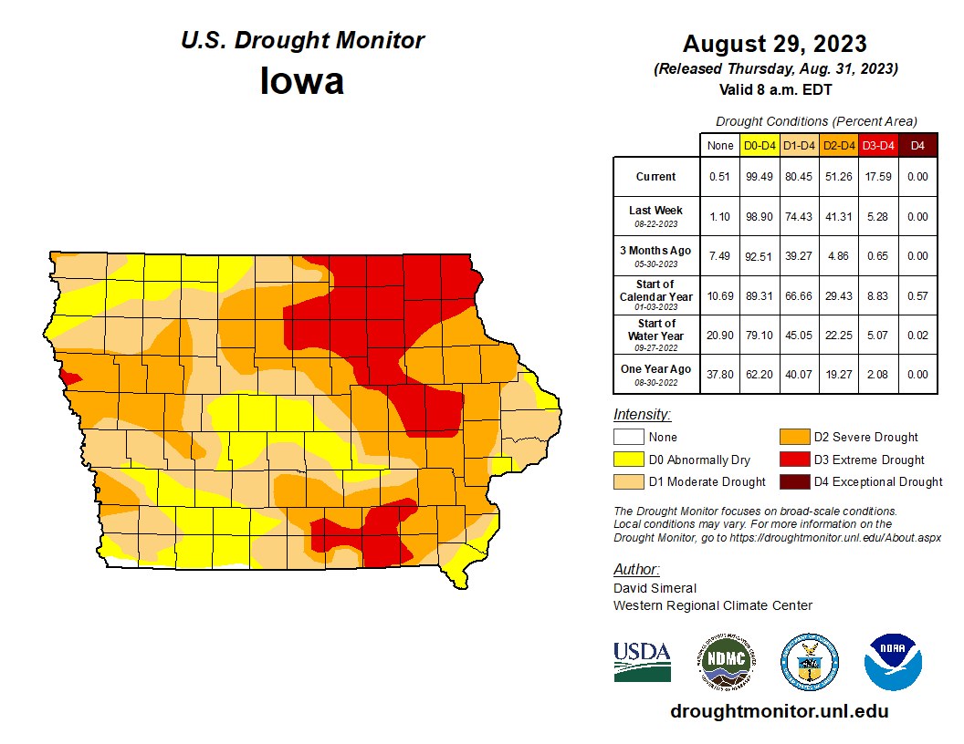
Extreme drought conditions are being experienced in a large portion of northeastern Iowa, and parts of seven southeastern Iowa counties.


