
The Freese-Notis Weather Forecast for the KJAN listening area and weather info. for Atlantic.

Podcast: Play in new window | Download (1.0MB)
Subscribe: RSS
345 AM CDT FRI OCT 17 2014 – (from the Nat’l Weather Service in Des Moines)
EARLY THIS MORNING…MOSTLY CLOUDY. WEST WIND 5 TO 15 MPH.
TODAY…MOSTLY CLOUDY. BREEZY…COOLER. HIGH IN THE UPPER 50S. NORTHWEST WIND 10 TO 20 MPH WITH GUSTS TO AROUND 30 MPH.
TONIGHT…MOSTLY CLOUDY. LOW IN THE UPPER 30S. NORTH WIND 5 TO 15 MPH.
SATURDAY…MOSTLY SUNNY. HIGH IN THE UPPER 50S. NORTH WIND NEAR 10 MPH.
SATURDAY NIGHT...MOSTLY CLEAR. LOW AROUND 40. SOUTH WIND NEAR 5 MPH.
SUNDAY...MOSTLY SUNNY. HIGH IN THE MID 60S. SOUTH WIND 5 TO 15 MPH.
SUNDAY NIGHT…PARTLY CLOUDY. LOW IN THE MID 40S.
MONDAY THROUGH WEDNESDAY…MOSTLY CLEAR. HIGH IN THE MID 60S. LOW IN THE MID 40S.
Shelby County Emergency Service Officials, including Fire Chiefs, Law Enforcement, and Emergency Management will begin twice weekly updates on local fire danger conditions. Signs placed strategically in each community, primarily at the fire Stations will indicate what the fire danger is for any particular day.
This program, implemented in 2010, resulted in a reduction of fire responses countywide. The continuous bi weekly fire danger assessments are provided by email to the media, Fire Chiefs, and others who support the program on their web pages, through radio, and cable TV information pages. This has, at times, reduced the need for our county to implement a complete burn ban.
When someone has the need to burn a pile of brush, debris, or buildings, they are asked to contact the Emergency Management Agency at 755-2124. The dispatchers will obtain the location and nature of the planned burn and will provide the caller with the Fire Chiefs contact information. Through this expanded communication process, we have found some burns can be rescheduled to a different time of day, where wind and moistures are more acceptable. The Fire Chiefs can have input as to how the burn can be conducted safely and be aware of the activity should it become unmanageable.
Shelby County has four color coded distinct levels:
LOW – You are asked to call in and report your burning projects to dispatch at 712-755-2124, and notify your local Fire Chief.
Moderate – You are asked to call in and report your burning projects to dispatch at 712-755-2124, and notify your local Fire Chief. Timing for burns should be morning, or evening hours and extinguished by dark unless authorized by Fire Chief due to possible impacts to roads and health from smoke. Burns must be monitored at all times.
High – Burning of any kind is restricted unless approval is received from local Fire Chief. Controlled burns that are not reported will result in Fire Department being dispatched, and fires extinguished if determined to be un-safe. Please call 712-755-2124 with questions.
Extreme – Burning is prohibited, unless you have a signed permit from the local Fire Chief. Fires on Extreme days can grow rapidly and pose a risk to the Health and Safety of the Community.
If you have any questions please call 712-755-2124.
Below average temperatures are favored in parts of the south-central and southeastern United States, while above-average temperatures are most likely in the western U.S., Alaska, Hawaii and New England, according to the U.S. Winter Outlook, issued today by NOAA’s Climate Prediction Center.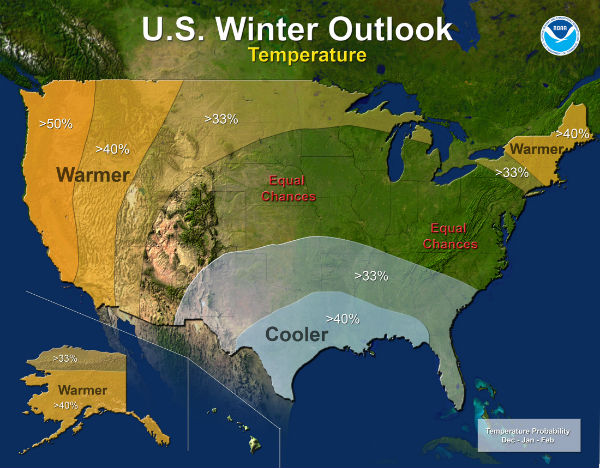
While drought may improve in some portions of the U.S. this winter, California’s record-setting drought will likely persist or intensify in large parts of the state. Nearly 60 percent of California is suffering from exceptional drought – the worst category – with 2013 being the driest year on record. Also, 2012 and 2013 rank in the top 10 of California’s warmest years on record, and 2014 is shaping up to be California’s warmest year on record. Winter is the wet season in California, so mountainous snowfall will prove crucial for drought recovery. Drought is expected to improve in California’s southern and northwestern regions, but improvement is not expected until December or January.
El Niño, an ocean-atmospheric phenomenon in the Tropical Pacific that affects global weather patterns, may still develop this winter. Climate Prediction Center forecasters announced on Oct. 9 that the ocean and atmospheric coupling necessary to declare an El Niño has not yet happened, so they continued the El Niño Watch with a 67 percent chance of development by the end of the year. While strong El Niño episodes often pull more moisture into California over the winter months, this El Niño is expected to be weak, offering little help.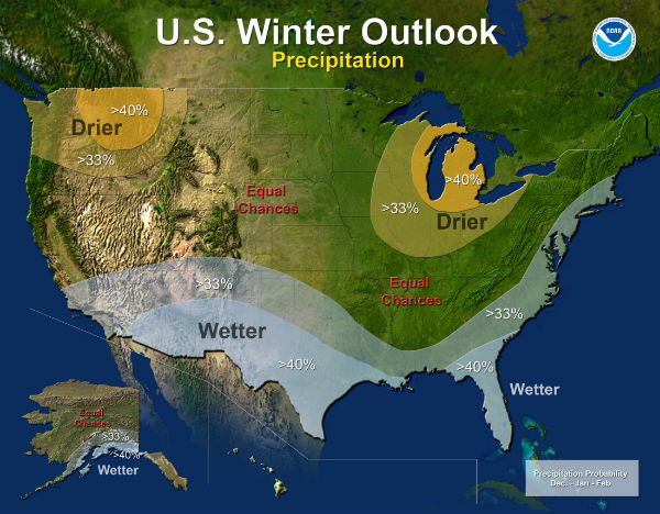
The Precipitation Outlook favors above-average precipitation across the southern tier, from the southern half of California, across the Southwest, South-central, and Gulf Coast states, Florida, and along the eastern seaboard to Maine. Above-average precipitation also is favored in southern Alaska and the Alaskan panhandle. Below-average precipitation is favored in Hawaii, the Pacific Northwest and the Midwest.
Last year’s winter was exceptionally cold and snowy across most of the United States, east of the Rockies. A repeat of this extreme pattern is unlikely this year, although the Outlook does favor below-average temperatures in the south-central and southeastern states.
In addition, the Temperature Outlook favors warmer-than-average temperatures in the Western U.S., extending from the west coast through most of the inter-mountain west and across the U.S.-Canadian border through New York and New England, as well as Alaska and Hawaii.
The rest of the country falls into the “equal chance” category, meaning that there is not a strong enough climate signal for these areas to make a prediction, so they have an equal chance for above-, near-, or below-normal temperatures and/or precipitation.
The U.S. Seasonal Drought Outlook, updated today and valid through January, predicts drought removal or improvement in portions of California, the Central and Southern Plains, the desert Southwest, and portions of New York, Connecticut, Rhode Island and Massachusetts. Drought is likely to persist or intensify in portions of California, Nevada, Utah, Idaho, Oregon and Washington state. New drought development is likely in northeast Oregon, eastern Washington state, and small portions of Idaho and western Montana.
This seasonal outlook does not project where and when snowstorms may hit or provide total seasonal snowfall accumulations. Snow forecasts are dependent upon the strength and track of winter storms, which are generally not predictable more than a week in advance.
(Wednesday’s High in Atlantic was 69, our low this morning 33.)
Today – Sunny, with a high near 71. South southeast wind 6 to 14 mph becoming west northwest in the afternoon. Winds could gust as high as 20 mph.
Tonight – Mostly clear, with a low around 45. West northwest wind around 9 mph.
Friday – Mostly sunny, with a high near 60. Windy, with a northwest wind 11 to 21 mph, with gusts as high as 29 mph.
Friday Night – Partly cloudy, with a low around 38. North northwest wind 8 to 13 mph, with gusts as high as 18 mph.
Saturday – Sunny, with a high near 56. North wind 5 to 8 mph.
Saturday Night – Mostly clear, with a low around 38.
Sunday – Mostly sunny, with a high near 63.
The Freese-Notis Weather Forecast:
Today: Sunny, with a high near 66. North northwest wind 5 to 10 mph.
Tonight: Clear, with a low around 39. Calm wind becoming south around 5 mph after midnight.
Thursday: Sunny, with a high near 72. South wind 5 to 15 mph becoming west northwest in the afternoon.
Thu. Night: Mostly clear, with a low around 47. West northwest wind around 5-10 mph.
Friday: Sunny & breezy, with a high near 62. West northwest wind 10 to 15 mph, with gusts as high as 25 mph.
Friday Night: Mostly clear, with a low around 39.
Saturday: Sunny, with a high near 57.
*********
Tuesday’s High in Atlantic was 65. Our 24-hour low (ending at 7-a.m. today) was 33. At 7-a.m. it was 34.
Here are some rainfall reports for the past 24-hours ending at 7-a.m. Tue., Oct. 14, 2014 (reports from Nat’l. Weather Service Cooperative observers and media)
Atlantic @ KJAN, .73”; Anita, 1.4”; Audubon, 1.2”; Avoca, 1.2”; Bedford, 1.75”; Carroll, .56”; Clarinda, 1.46”’ Emerson, 1.35”; Irwin, .77”; Massena, 1.37”; Oakland, .90”; Shenandoah, 1.28”; Sidney, .75”; Villisca, 1.7”.
The Freese-Notis weather forecast for Atlantic & the KJAN listening area, and weather data for Atlantic, including recent rainfall and Hi/Lo temps.
Podcast: Play in new window | Download (1.0MB)
Subscribe: RSS
Today A 20 percent chance of rain before 9am. Mostly sunny, with a high near 62. Windy, with a north wind 21 to 25 mph, with gusts as high as 36 mph.
Tonight Mostly clear, with a low around 39. North wind 9 to 15 mph, with gusts as high as 21 mph.
Wednesday Sunny, with a high near 65. North wind around 9 mph.
Wednesday Night Mostly clear, with a low around 41. Light and variable wind.
Thursday Sunny, with a high near 69. Light and variable wind becoming southwest 5 to 10 mph in the morning.
Thursday Night Mostly clear, with a low around 46.
Friday Sunny, with a high near 65.
The latest rains across Iowa continue to add to what is now a positive groundwater picture. Tim Hall, who tracks groundwater levels for the Iowa Department of Natural Resources, says we can officially put the word drought away for awhile when referring to the state’s water situation. Hall says it wasn’t that long ago when many were wondering if that would be possible. “I look back at the drought monitor from one year ago — from the middle of October last year — and it was really bleak about one year ago,” Hall says. “Most of the state was in some sort of drought, and it had sort of been lingering for a long time.”
Hall says things were dry going back even farther to the fall of 2011. “It’s nice now to get to the point where it appears that the long-term gradual moisture from this year has really pushed the drought out of the state. It’s nice to see. It’s been really wet going into the fall, this is what we like to see, so yeah, it’s in pretty good shape,” Hall says. The last remnants of the drought had hung on until September’s above normal rainfall.
“For awhile that northeastern corner of the state into southwest Wisconsin had been a little on the dry side — but we are out of it in Iowa right now. We’ve been out if for a month and it’s dramatically better than it was a year ago,” according to Hall. He says things seemed to balance out this spring, and the drier conditions actually helped prevent problems during a wet periods.
“The National Weather Service folks have pointed out that one of the things that really worked to the benefit of the state of Iowa this year given the spring rain, was that we did have very dry soil conditions back in the spring,” Hall says, “so, we were able to absorb a lot of the rainfall that came early in the spring season because the soil was so dry.”
The U-S-D-A National Agricultural Statistics Service says the subsoil moisture levels measured on October 5th had been greater only twice — in 2007 and 2010 — among the past 20 years.
(Radio Iowa)


