
Today – Sunny, with a high near 60. South southwest wind 8 to 10 mph.
Tonight – Patchy fog between 10pm and 5am. Otherwise, partly cloudy, with a low around 25. Light and variable wind becoming north 6 to 11 mph after midnight.
Sunday – Partly sunny, with a temperature falling to around 15 by 5pm. Wind chill values as low as zero. Windy, with a north wind 15 to 21 mph, with gusts as high as 29 mph.
Sunday Night – Mostly cloudy, with a low around 8. Wind chill values as low as -5. North wind 11 to 14 mph, with gusts as high as 18 mph.
Monday – Mostly sunny, with a high near 22. North wind 7 to 11 mph becoming east in the afternoon.
Tuesday – Mostly sunny, with a high near 34. Breezy.
Today: Mostly sunny, with a high near 48. South wind 5 to 10 mph.
Tonight: Patchy fog after 9pm. Otherwise, partly cloudy, with a low around 31. South southwest wind 5 to 10 mph.
Saturday: Patchy fog before 9am. Otherwise, mostly sunny, with a high near 56. South southwest wind 5 to 10 mph.
Saturday Night: Patchy fog. Otherwise, partly cloudy, with a low around 29. South southwest wind 5 to 10 mph becoming north after midnight.
Sunday: Mostly sunny, with a high near 29. Windy, with a north wind 15 to 25 mph, with gusts as high as 30 mph.
Monday: Mostly sunny, with a high near 22.
Tuesday: Mostly sunny, with a high near 34. Breezy.

Podcast: Play in new window | Download (625.2KB)
Subscribe: RSS
The KJAN listening area forecast and weather information for Atlantic.
Podcast: Play in new window | Download (801.4KB)
Subscribe: RSS
345 AM CST THU NOV 27 2014
EARLY THIS MORNING…PARTLY CLOUDY. MUCH COLDER. NORTHWEST WIND 5 TO 10 MPH.
TODAY…PARTLY SUNNY. HIGH IN THE MID 20S. NORTHEAST WIND 5 TO 10 MPH SHIFTING TO THE SOUTHEAST IN THE AFTERNOON.
TONIGHT…MOSTLY CLOUDY THROUGH MIDNIGHT THEN BECOMING PARTLY CLOUDY. NOT AS COLD. LOW IN THE LOWER 20S. SOUTHEAST WIND 10 TO 15 MPH.
FRIDAY...MOSTLY SUNNY. WARMER. HIGH IN THE MID 40S. SOUTH WIND 5 TO 10 MPH.
FRIDAY NIGHT…PARTLY CLOUDY. NOT AS COLD. AREAS OF FOG. LOW IN THE LOWER 30S. SOUTHWEST WIND 5 TO 10 MPH.
SATURDAY…MOSTLY SUNNY. AREAS OF FOG IN THE MORNING. HIGH IN THE MID 50S. SOUTHWEST WIND 5 TO 10 MPH.
SUNDAY…MOSTLY SUNNY. BREEZY. MUCH COLDER. HIGH IN THE LOWER 30S.
The National Weather Service in Johnston has updated its snowfall report for communities in southwest and western Iowa. The report includes:
2.5″ in Audubon; 2″ in Bedford and Winterset; 1.5″ in Massena; 1.4″ near Bagley; 1.1″ in Atlantic (at KJAN); and 1″ of snow in Carroll.
At the Weather Service office in Johnston, officials measured 3.4″ of snow. Estherville, in northwest Iowa picked up 4″. Fort Dodge reported 3.2″. South of Ft. Dodge, a storm spotter reported 5 inches of snow had fallen. Snowfall rates in south central Iowa, were generally around two-inches, with the exception of Lorimor, in Union County, which reported three-inches of snow.
Travel with caution this morning. Roads in western Iowa are partially to mostly covered with snow and/or slush. The far western part of the state has the best road conditions (“Normal”), according to 511ia.org For the latest road condition reports, call 5-1-1 or surf to the Iowa DOT’s website (511ia.org). 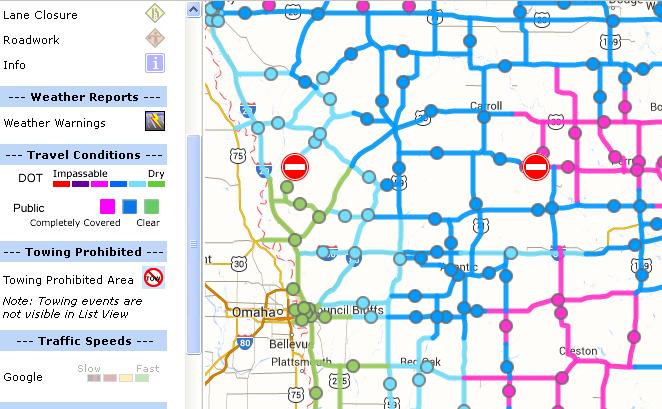
The Freese-Notis Weather forecast for Atlantic & the KJAN listening area, and weather information for Atlantic, including overnight snowfall.
Podcast: Play in new window | Download (804.8KB)
Subscribe: RSS
400 AM CST WED NOV 26 2014
EARLY THIS MORNING…PERIODS OF SNOW AND RAIN. NOT AS COLD. NEW SNOW ACCUMULATION UP TO 1 INCH. TOTAL SNOW ACCUMULATION UP TO 2 INCHES. SOUTH WIND 10 TO 15 MPH WITH GUSTS TO AROUND 25 MPH. CHANCE OF PRECIPITATION NEAR 100 PERCENT.
TODAY...CLOUDY. A CHANCE OF LIGHT RAIN AND LIGHT SNOW THROUGH MID MORNING…THEN A SLIGHT CHANCE OF LIGHT RAIN AND LIGHT SNOW BEFORE NOON. BREEZY. HIGH IN THE MID 30S. NORTHWEST WIND 10 TO 15 MPH INCREASING TO 20 TO 25 MPH IN THE AFTERNOON. CHANCE OF PRECIPITATION 40 PERCENT.
TONIGHT…MOSTLY CLOUDY UNTIL EARLY MORNING THEN BECOMING PARTLY CLOUDY. BREEZY…COLDER. LOW AROUND 10. NORTH WIND 15 TO 20 MPH WITH GUSTS TO AROUND 30 MPH DECREASING TO 5 TO 10 MPH AFTER MIDNIGHT.
THANKSGIVING DAY…MOSTLY SUNNY. HIGH IN THE MID 20S. NORTH WIND AROUND 5 MPH SHIFTING TO THE SOUTHEAST IN THE AFTERNOON.
THURSDAY NIGHT…MOSTLY CLOUDY THROUGH MIDNIGHT THEN BECOMING PARTLY CLOUDY. NOT AS COLD. LOW IN THE LOWER 20S. SOUTH WIND 5 TO 15 MPH.
FRIDAY...MOSTLY SUNNY. WARMER. HIGH IN THE MID 40S. SOUTHWEST WIND 5 TO 10 MPH.
SATURDAY…MOSTLY SUNNY. HIGH IN THE LOWER 50S.
Many Iowans may need to schedule their Thanksgiving holiday travel plans around those of Mother Nature. National Weather Service Meteorologist Kurt Kotenberg says one to four inches of snow is expected across the state tonight (Tue) into tomorrow (Wed) morning. “Most of the snow is going to be in northern and north-central Iowa,” Kotenberg said. “So, we’re looking at maybe three to four inches of snow from around the Estherville area, along Interstate 35, north of Ames.” Much of central Iowa, south of Ames, can expect two to three inches of snow. Western and eastern Iowa are forecast to receive around an inch of snow. The snow may present some challenges for motorists.
“I think by 7 a.m., a good part of central Iowa will probably have around one to two inches of snow already fallen,” Kotenberg said. “That means by the time a lot of us head out Wednesday morning, those roadways might already be snow covered and a little bit slippery.” The snow will be followed by a big blast of cold air. “Wind speeds will pick up behind this. We’ll probably see winds of around 15 to 20 miles an hour Wednesday night into Thursday morning,” Kotenberg said.
Some blowing snow is possible on Wednesday. High temperatures on Wednesday will range from the upper 20s to mid 30s, with overnight lows dipping into the single digits.. Highs on Thursday are expected in the teens and 20s.
(Radio Iowa)
355 AM CST TUE NOV 25 2014
EARLY THIS MORNING…MOSTLY CLEAR. NORTHWEST WIND 5 TO 10 MPH.
TODAY…SUNNY. HIGH IN THE UPPER 30S. WEST WIND 5 TO 10 MPH SHIFTING TO THE SOUTHWEST IN THE AFTERNOON.
TONIGHT…NOT AS COLD. A CHANCE OF SNOW IN THE EVENING…THEN SNOW LIKELY BEFORE MIDNIGHT. SNOW AFTER MIDNIGHT. SNOW ACCUMULATION OF 1 TO 2 INCHES. LOW AROUND 30. SOUTH WIND 5 TO 15 MPH. CHANCE OF SNOW 80 PERCENT.
WEDNESDAY…CLOUDY. A CHANCE OF SNOW IN THE MORNING…THEN A SLIGHT CHANCE OF LIGHT SNOW IN THE AFTERNOON. BREEZY. HIGH IN THE LOWER 30S. NORTHWEST WIND 10 TO 20 MPH WITH GUSTS TO AROUND 30 MPH. CHANCE OF SNOW 50 PERCENT.
THANKSGIVING DAY…PARTLY SUNNY. HIGH IN THE UPPER 20S. NORTH WIND 5 TO 10 MPH SHIFTING TO THE EAST IN THE AFTERNOON.
FRIDAY…PARTLY CLOUDY. NOT AS COOL. HIGH IN THE LOWER 40S.


