
Snowblowers are droning and shovels are scraping concrete as most Iowans are digging out from a weekend that brought heavy snow to much of the state. Winter Storm Warnings were issued from Saturday afternoon into Sunday night as the steady rain changed to heavy snow. Meteorologist Brad Small, at the National Weather Service in Johnston, says virtually all of Iowa got at least some snow and many cities got more than a foot.
“Really, the worst-hit areas were from southwest Iowa through the northern Des Moines metro area,” Small says. “We had, here at the office, 14.2 inches and amounts from 8-to-13 inches were pretty common…through the Cedar Rapids area to just north of the Quad Cities. There’s about a third of the state saw better than ten inches.”
Many churches across the state cancelled worship services on Sunday and some flights were cancelled at Des Moines International Airport, while today (Monday), schools in Cedar Rapids, Iowa City, Dubuque and other districts have canceled classes and Mason City and Ames, among others, started late. Meteorologist Jim Lee, at the National Weather Service, says the most remarkable aspect of the storm was the precipitation amounts. Lee says, “When you took the total of the rain and melted snow, some areas got more precipitation in 24 hours than they normally see in the entire month of January.”
A week ago, a warm-up washed over Iowa and brought high temperatures in the 50s and 60s to many areas. That’s long gone, though, and Lee says this snow will be sticking around for a while. “The first chance to even get above freezing in most areas is around Friday and that won’t be by much,” Lee says. “So, we may see just a little bit of melting and certainly some compaction but no significant warmups or melting on the horizon.”
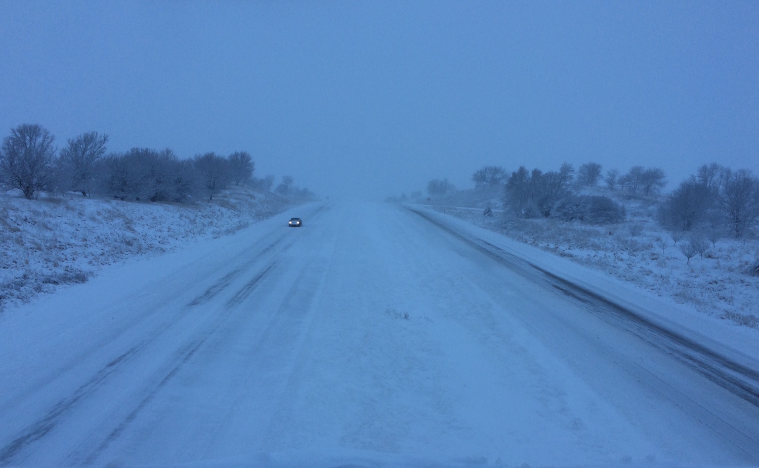
Highways in southwestern, central and eastern Iowa are still covered with snow according to Iowa Department of Transportation road conditions website. A 48-mile stretch of Highway 6 in southwest Iowa, between Council Bluffs and Griswold, was declared “impassible” due to drifting and blowing snow bringing white-out conditions.
(Radio Iowa)
The Freese-Notis weather forecast for the KJAN listening area, and weather information for Atlantic.

Podcast: Play in new window | Download (1.1MB)
Subscribe: RSS
345 AM CST MON FEB 2 2015
EARLY THIS MORNING…MOSTLY CLEAR. BITTERLY COLD. NORTHWEST WIND 5 TO 15 MPH. WIND CHILL READINGS AROUND 15 BELOW.
TODAY…MOSTLY SUNNY. VERY COLD. HIGH 15 TO 20. WEST WIND NEAR 5 MPH INCREASING TO SOUTH 10 TO 15 MPH IN THE AFTERNOON.
TONIGHT…MOSTLY CLOUDY THROUGH MIDNIGHT THEN BECOMING PARTLY CLOUDY. NOT AS COLD. LOW 5 TO 10 ABOVE. SOUTHWEST WIND 5 TO 10 MPH.
TUESDAY…PARTLY SUNNY. A 20 PERCENT CHANCE OF LIGHT SNOW IN THE AFTERNOON. WARMER. HIGH IN THE UPPER 20S. WEST WIND NEAR 5 MPH SHIFTING TO THE SOUTHEAST IN THE AFTERNOON.
WEDNESDAY…CLOUDY WITH A 50 PERCENT CHANCE OF SNOW. HIGH 15 TO 20. NORTH WIND AROUND 15 MPH WITH GUSTS TO AROUND 25 MPH.
THURSDAY…SUNNY. HIGH 15 TO 20.
Unofficial snowfall amounts reported to the National Weather Service in Des Moines for the snowstorm that occurred Saturday and Sunday, include the following:
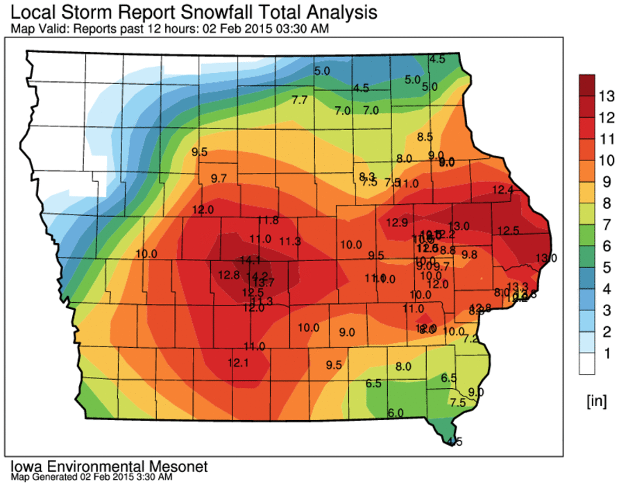
Snowfall report graphic from the NWS
URGENT - WINTER WEATHER MESSAGE
NATIONAL WEATHER SERVICE DES MOINES IA
908 PM CST SUN FEB 1 2015

.COLD AIR IS FILTERING INTO IOWA IN THE WAKE OF THE WINTER STORM.
HIGH PRESSURE OVER THE DAKOTAS WILL MOVE INTO NORTHWEST IOWA
TONIGHT.
SAC-CRAWFORD-CARROLL-GREENE-

...WIND CHILL ADVISORY REMAINS IN EFFECT FROM 3 AM TO 9 AM CST
MONDAY...

* TEMPERATURES/WIND CHILL VALUES...TEMPERATURES WILL FALL INTO THE
  5 TO 10 BELOW ZERO RANGE TONIGHT. WIND CHILL VALUES WILL FALL TO
  20 TO 25 DEGREES BELOW ZERO.

* WINDS...NORTHWEST WINDS...GUSTY AT TIMES...WILL DIMINISH
  OVERNIGHT TO 8 TO 15 MPH BY SUNRISE.

* IMPACTS...ROADS AND TRAVEL WILL REMAIN HAZARDOUS DUE TO THE
  SNOWFALL OF THE PAST 24 HOURS. SOME BLOWING AND DRIFTING SNOW
  CAN BE EXPECTED UNTIL AFTER MIDNIGHT.

PRECAUTIONARY/PREPAREDNESS ACTIONS...

A WIND CHILL ADVISORY MEANS THAT VERY COLD AIR AND STRONG WINDS
WILL COMBINE TO GENERATE LOW WIND CHILLS. THIS WILL RESULT IN
FROST BITE AND LEAD TO HYPOTHERMIA IF PRECAUTIONS ARE NOT TAKEN.
IF YOU MUST VENTURE OUTDOORS...MAKE SURE YOU WEAR A HAT AND
GLOVES.
AREA COUNTIES: MONONA-HARRISON-SHELBY-POTTAWATTAMIE-MONTGOMERY-PAGE– 547 PM CST SUN FEB 1 2015
...WINTER WEATHER ADVISORY IN EFFECT UNTIL 9 PM CST THIS EVENING…
…WINTER STORM WARNING IS CANCELLED...
THE NATIONAL WEATHER SERVICE IN OMAHA/VALLEY HAS ISSUED A WINTER WEATHER ADVISORY FOR BLOWING SNOW…WHICH IS IN EFFECT UNTIL 9 PM CST THIS EVENING. THE WINTER STORM WARNING HAS BEEN CANCELLED.
* TIMING…BLOWING SNOW WILL CONTINUE EARLY THIS EVENING THEN WILL END BY 9 PM AS WINDS DIMINISH.
* MAIN IMPACT…ROADS ARE SNOW COVERED…ICY AND HAZARDOUS. THE BLOWING SNOW WILL CONTINUE TO REDUCE VISIBILITY THIS EVENING…ESPECIALLY IN OPEN AND RURAL AREAS.
* OTHER IMPACTS…THE COLD COMBINED WITH THE WIND WILL CREATE WIND CHILLS 10 TO 20 BELOW ZERO.
PRECAUTIONARY/PREPAREDNESS ACTIONS…
A WINTER WEATHER ADVISORY FOR BLOWING SNOW MEANS THAT VISIBILITIES WILL BE LIMITED DUE TO STRONG WINDS BLOWING SNOW AROUND. USE CAUTION WHEN TRAVELING…ESPECIALLY IN OPEN AREAS.
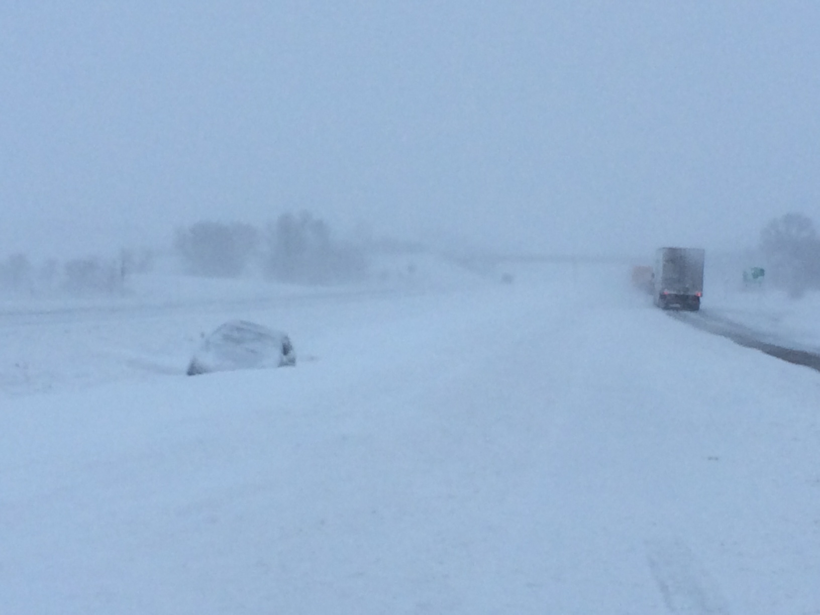
AMES, Iowa – Feb 1, 2015 – Most of Iowa’s roads are completely or partially covered with snow and ice with travel not advised in portions of Eastern Iowa.
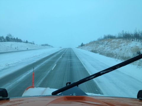
I 80 W Mile Marker 70. IA DOT Snowplow View 5:14-pm 2/1/15
Windy conditions with continued snowfall are expected through the evening hours causing hazardous driving conditions. The Iowa Department of Transportation is working to clear roads, but blowing snow can cause roadways to quickly become re-covered after trucks pass through. Visibility can also be greatly reduced due to blowing snow.
Iowa DOT reminds travelers that trips during severe winter weather can take three or four times longer than normal. Motorists are urged to monitor weather and road conditions before traveling and evaluate the necessity of trips. Often, the safest option is to skip the trip altogether. For road condition information visit the Iowa 511 website at http://511ia.org or call 511 within Iowa, or 800-288-1047 from outside the state. Tow ban information can be found on the full-featured version of the website.
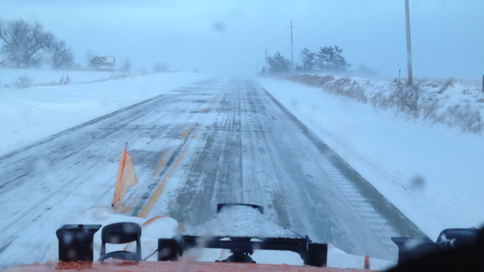
Hwy 83 eastbound at mm 31 (2/1/15)
To see photos of conditions on the roadway from the dash of an Iowa DOT snowplow truck or plow locations visit http://trackaplow.iowadot.gov.
115 PM CST SUN FEB 1 2015
…WINTER STORM WARNING IN EFFECT UNTIL 9 PM CST THIS EVENING…
REST OF TODAY…SNOW. AREAS OF BLOWING SNOW. BREEZY. NEW SNOW ACCUMULATION AROUND 1 INCH. TOTAL SNOW ACCUMULATION 3 TO 4 INCHES. HIGH IN THE LOWER 30S. NORTH WIND 20 TO 25 MPH WITH GUSTS TO AROUND 40 MPH. CHANCE OF SNOW 90 PERCENT.
TONIGHT…VERY COLD. PATCHY BLOWING SNOW IN THE EVENING. CLOUDY WITH LIGHT SNOW LIKELY IN THE EVENING…THEN MOSTLY CLOUDY OVERNIGHT. BREEZY. LITTLE OR NO SNOW ACCUMULATION. LOW 5 TO 10 BELOW. NORTH WIND 15 TO 25 MPH BECOMING NORTHWEST 5 TO 10 MPH WITH GUSTS TO AROUND 20 MPH AFTER MIDNIGHT. CHANCE OF SNOW 60 PERCENT.
MONDAY...MOSTLY SUNNY UNTIL LATE AFTERNOON THEN BECOMING MOSTLY CLOUDY. VERY COLD. HIGH 15 TO 20. SOUTHWEST WIND 5 TO 15 MPH. LOWEST WIND CHILL READINGS AROUND 15 BELOW IN THE MORNING.
MONDAY NIGHT…MOSTLY CLOUDY THROUGH MIDNIGHT THEN BECOMING PARTLY CLOUDY. NOT AS COLD. LOW AROUND 10. SOUTHWEST WIND 5 TO 15 MPH.
TUESDAY…PARTLY SUNNY. A SLIGHT CHANCE OF LIGHT SNOW IN THE MORNING…THEN A CHANCE OF SNOW IN THE AFTERNOON. WARMER. HIGH AROUND 30. SOUTHWEST WIND 5 TO 10 MPH. CHANCE OF SNOW 30 PERCENT.
TUESDAY NIGHT…MOSTLY CLOUDY. A 20 PERCENT CHANCE OF LIGHT SNOW AFTER MIDNIGHT. LOW 10 TO 15.
WEDNESDAY…MOSTLY CLOUDY WITH A 40 PERCENT CHANCE OF SNOW. COLDER. HIGH AROUND 20.
Winds have been picking up this morning across western Iowa, causing blowing and drifting of snow. The Iowa DOT’s website at 511ia.org reports all roadways are 100-percent snow and/or ice covered. Travel is not advised.
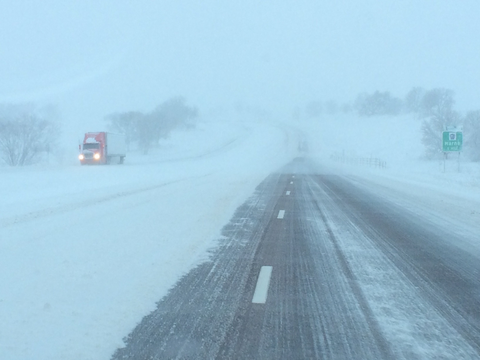
I-80 eastbound at Exit 57
I-80 westbound at Exit 57

I-80 westbound at the 53 mile marker
I-80 westbound at the 46-mile marker
Iowa State Patrol Trooper Wayne Brosam sent KJAN some pictures he took of the roadways as of 8:30-a.m. today.
858 AM CST SUN FEB 1 2015
A WINTER STORM WARNING REMAINS IN EFFECT UNTIL 9 PM CST THIS EVENING.
* SHORT TERM TRENDS…WIDESPREAD LIGHT TO MODERATE SNOW WILL CONTINUE WITH STEADILY INCREASING WINDS ACROSS NORTHERN AND WESTERN IOWA. WINDS WILL INCREASE THIS AFTERNOON REGIONWIDE.
* STORM TOTAL SNOW…ACCUMULATIONS OF GENERALLY 8 TO 12 INCHES. SOME LOCATIONS WILL RECEIVE OVER A FOOT OF SNOW.
* WINDS/VISIBILITY…NORTHEAST WINDS GRADUALLY INCREASING AND BECOMING NORTHERLY BY AFTERNOON. GUSTS INCREASING TO 35 TO 40 MPH OVER WESTERN AND NORTHERN IOWA BY MIDDAY AND OVER THE REMAINDER OF THE AREA BY EARLY TO MID AFTERNOON. WINDS WILL REMAIN STRONG THROUGH EARLY EVENING.
* TEMPERATURES…TEMPERATURES WILL CONTINUE TO FALL THROUGH THE AFTERNOON HOURS INTO THE LOWER TO MID TEENS BY EVENING. ALONG WITH THAT WIND CHILL VALUES WILL DROP TO 5 TO 10 BELOW ZERO OVER THE NORTHERN HALF OF IOWA AND JUST BELOW ZERO OVER CENTRAL AND SOUTHERN IOWA BY LATE AFTERNOON.
* IMPACTS…ROADS WILL REMAIN SNOW COVERED AND SLICK WITH HAZARDOUS DRIVING CONDITIONS. BLOWING AND DRIFTING SNOW WILL BECOME MORE SIGNIFICANT THROUGH THE DAY. VISIBILITIES WILL OFTEN BE BELOW A MILE WITH NEAR WHITEOUT CONDITIONS POSSIBLE AT TIMES…ESPECIALLY IN OPEN AND RURAL AREAS. THE HEAVY WET NATURE OF THE SNOW HAS ALSO COATED TREES OVER CENTRAL AND SOUTHERN IOWA. TREE DAMAGE AND LOCALIZED POWER OUTAGES MAY BECOME MORE LIKELY AS THE WINDS INCREASE THROUGH THE AFTERNOON.


