
Today – Sunny, with a high near 19. Wind chill values as low as -25. Breezy, with a south wind 5 to 10 mph increasing to 12 to 17 mph in the afternoon. Winds could gust as high as 24 mph.
Tonight – Partly cloudy, with a low around 14. Wind chill values as low as zero. South southwest wind 7 to 13 mph.
Friday – Partly sunny, with a high near 37. Wind chill values as low as 5. South wind 8 to 13 mph.
Friday Night – Partly cloudy, with a low around 24. Southwest wind 6 to 8 mph.
Saturday – Mostly sunny, with a high near 42. South southwest wind 6 to 11 mph.
Saturday Night – Partly cloudy, with a low around 25.
Sunday – Mostly sunny, with a high near 39.
(Updated 10:45-a.m.
Snowfall reports from trained weather spotters & others, to the National Weather Service (time of report submitted, as indicated):
Atlantic (8:45-a.m.) 3.3″; Audubon, 2.0” (7-am); Essex 4.0″ (10:30-a.m.); 2 miles NW of Little Sioux in Harrison County, 1.3″ (7:30-am);Logan, 2.2″ (7:30-am); Massena, 1.5” (7:30-a.m.); Mt. Ayr, 1.3″ (8-am); Oakland, 1.1” (7:30-am); Red Oak, 4.0″ (9:50-a.m.); Shenandoah, 2.0″ (10:30-a.m.); Underwood, 1.4″ (10:30-a.m.)
Snow is moving across southern Iowa this morning. The National Weather Service in Johnston says snow fall totals will range from 1 to 3 inches south of Interstate 80 with the highest totals near the Missouri border.Winter Weather Advisories for snow and blowing snow have been posted for all counties along and south in I-80 thru the mid-day hours. Roads have become snow covered and with winds gusting up to 20 miles per hour, visibilities will fall below one-mile, especially in areas of heavier snowfall. Use caution while driving today.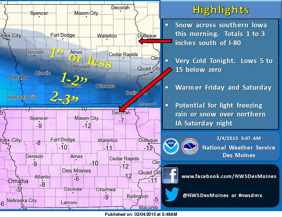
High Pressure will arrive tonight and will bring very cold temperatures to the state. Overnight lows will be 5 to 15 degrees below zero. Warmer temperatures arrive Friday into Saturday. Highs in the 30s and 40s are possible during this period.
CASS-ADAIR-MADISON COUNTIES…335 AM CST WED FEB 4 2015
…WINTER WEATHER ADVISORY IN EFFECT UNTIL 1 PM CST THIS AFTERNOON…
POTTAWATTAMIE-MILLS-MONTGOMERY COUNTIES: WINTER WEATHER ADVISORY IN EFFECT UNTIL NOON TODAY.
ADAMS-UNION-TAYLOR AND RINGGOLD COUNTIES: WINTER WEATHER ADVISORY IN EFFECT FROM 6-AM TODAY UNTIL 1-P.M.
FREMONT AND PAGE COUNTIES: WINTER WEATHER ADVISORY IN EFFECT UNTIL 1-P.M.
THE NATIONAL WEATHER SERVICE IN DES MOINES HAS ISSUED A WINTER WEATHER ADVISORY FOR SNOW AND BLOWING SNOW…WHICH IS IN EFFECT UNTIL 1 PM CST THIS AFTERNOON.
* TIMING…SNOW WILL BEGIN BY SUNRISE IN SOUTHWEST IOWA AND MOVE ACROSS SOUTH CENTRAL IOWA BEFORE NOON.
* STORM TOTAL SNOW ACCUMULATIONS…2 TO 4 INCHES.
* WINDS/VISIBILITY…NORTH WINDS INCREASING TO 15 TO 20 MPH WITH HIGHER GUSTS BY LATE MORNING. VISIBILITY WILL FALL BELOW A MILE DURING HEAVIER SNOWFALL.
* IMPACTS…ROADS WILL BECOME SNOW COVERED AND LOW VISIBILITY WILL MAKE TRAVEL HAZARDOUS.
PRECAUTIONARY/PREPAREDNESS ACTIONS…
A WINTER WEATHER ADVISORY FOR SNOW MEANS THAT PERIODS OF SNOW WILL CAUSE PRIMARILY TRAVEL DIFFICULTIES. BE PREPARED FOR SNOW COVERED ROADS AND LIMITED VISIBILITIES…AND USE CAUTION WHILE DRIVING.
330 AM CST WED FEB 4 2015
…WINTER WEATHER ADVISORY IN EFFECT UNTIL 1 PM CST THIS AFTERNOON…
EARLY THIS MORNING…LIGHT SNOW LIKELY. NOT AS COLD. LITTLE OR NO NEW SNOW ACCUMULATION. NORTH WIND 10 TO 15 MPH. CHANCE OF SNOW 60 PERCENT.
TODAY…SNOW THROUGH MID MORNING…THEN CLOUDY WITH A CHANCE OF LIGHT SNOW BEFORE NOON. PARTLY SUNNY IN THE AFTERNOON. AREAS OF BLOWING SNOW BEFORE NOON. BREEZY…COLDER. SNOW ACCUMULATION AROUND 2 INCHES. HIGH 15 TO 20. NORTH WIND 15 TO 20 MPH. CHANCE OF SNOW NEAR 100 PERCENT.
TONIGHT…MOSTLY CLEAR. VERY COLD. LOW 5 TO 10 BELOW. NORTHWEST WIND NEAR 10 MPH SHIFTING TO THE WEST AFTER MIDNIGHT.
THURSDAY…MOSTLY SUNNY. VERY COLD. BREEZY. HIGH AROUND 20. SOUTH WIND 5 TO 10 MPH INCREASING TO 15 TO 20 MPH IN THE AFTERNOON. LOWEST WIND CHILL READINGS AROUND 15 BELOW IN THE MORNING.
FRIDAY…MOSTLY SUNNY. WARMER. HIGH IN THE UPPER 30S. SOUTHWEST WIND 5 TO 15 MPH.
SATURDAY…PARTLY SUNNY. HIGH IN THE MID 40S.
POTTAWATTAMIE-MILLS-MONTGOMERY-FREMONT-PAGE COUNTIES…
…WINTER WEATHER ADVISORY IN EFFECT FROM 2 AM TO NOON CST WEDNESDAY…
THE NATIONAL WEATHER SERVICE IN OMAHA/VALLEY HAS ISSUED A WINTER WEATHER ADVISORY FOR SNOW AND BLOWING SNOW…WHICH IS IN EFFECT FROM 2 AM TO NOON CST WEDNESDAY.
* TIMING…LIGHT SNOW WILL MOVE INTO THE ALBION AND COLUMBUS AREAS BY 2AM…SPREADING INTO THE OMAHA COUNCIL BLUFFS AND LINCOLN AREAS BY 4 OR 5AM…THEN DROPPING SOUTH DURING THE MORNING HOURS AND ENDING ACROSS THE AREA FROM NORTH TO SOUTH BETWEEN 8AM AND NOON.
* SNOW ACCUMULATIONS…2 TO 4 INCHES. SOME LOCATIONS MAY BE LIGHTER ON THE NORTHERN EDGE OF THE ADVISORY AND THERE COULD BE SOME POCKETS OF HIGHER AMOUNTS.
* MAIN IMPACT…THE LIGHT TO MODERATE SNOW AND BLOWING SNOW WILL AFFECT MORNING TRAVELERS. TRAVEL WILL BE DIFFICULT DUE TO VISIBILITY RESTRICTIONS FROM ACCUMULATING SNOW AND BLOWING SNOW.
* NORTH WINDS INCREASING TO 15 TO 25 MPH WITH GUSTS OF 30 TO 35 MPH.
* COLD AND WIND CHILLS…TEMPERATURES WILL ONLY BE IN THE TEENS WITH SINGLE DIGIT ABOVE AND BELOW ZERO WIND CHILLS. IT WILL BE MUCH COLDER THURSDAY MORNING.
The Freese-Notis forecast and weather information for Atlantic.

Podcast: Play in new window | Download (1.2MB)
Subscribe: RSS
The Iowa Dept. of Transportation’s website (511ia.org), indicates that Highway 6, from one-mile west of the Lewis turn-off, westward to Council Bluffs, is still impassible, with drifting on the roadway. Vehicles stuck on the road from Sunday’s snowstorm were preventing snow plows from making progress on clearing the route.
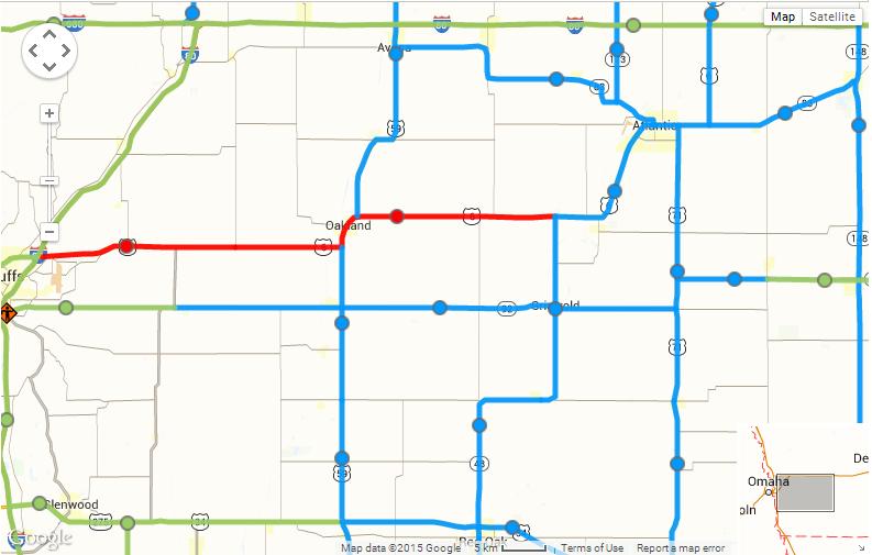
511ia.org IA DOT road conditions map (as of 5:58-a.m. Tue., 2/3/15)
The major arterial’s (Interstate 80, 680 and 29) are in normal driving condition this morning, while the secondary roads around western Iowa are partially covered with a mixture of ice/snow/slush.
Iowa’s weather during January featured several extremes. State climatologist Harry Hillaker says there were radical shifts in temperature, for starters, and despite the heavy snow that blanketed much of the state over the weekend, Iowa ended up lacking for precipitation during the month. “Very cold, generally speaking, for the first half of January, very mild and rather dry for the second half other than the big storm that came into the state on the very last day of January,” Hillaker says. “If we look at the state as a whole, the month ended up being about 2.3 degrees warmer than normal.”
In Atlantic, our average high for the month was 36. The average Low was 13. The normal High is 29, while the normal Low is 9. Most of Iowa got whalloped by a monster winter storm over the weekend that dumped up to 14-inches of snow on some areas of the state. Still, February 1st was Sunday, so the statewide average for precipitation during January was only about half-an-inch, which is about half the norm for the month.
“That basically does not include that event on the last day of the month,” Hillaker says. “For most of the official weather observers, their last report for the month would have come at 7 AM on January 31st, and all of that snow we had for the weekend came after that time, so it’ll end up in February’s records.”
In Atlantic, prior to the snow storm, we had received just 17 one-hundredths (.17”) of an inch of precipitation in January, from melted snowfall. Including snowfall for the 24-hour period that covered the 31st thru 7-a.m. Sunday, we received a total of .78” (78 one-hundredths of an inch) precipitation. Normal precipitation for the month is .84”
Hillaker says Iowa’s high and low temperatures for January were more than 90 degrees apart.
“Cherokee had the lowest temperature of the month, down to minus 24 degrees,” Hillaker says. “Then, toward the tail end of the month, right before the big snow event, we did have an impressive -for January- high of 67 degrees down in Shenandoah on the 28th day of the month.”
The lowest temp for the month in Atlantic, was -10 on the 12th and 13th of January. The warmest day was 59 degrees on the 16th. February started off much colder than normal and, for most of the state, much snowier than usual, too. Temperatures will likely stay below freezing this week and he says there will only be a little melting of the mounds of snow.
(Radio Iowa/KJAN weather records)
345 AM CST TUE FEB 3 2015
EARLY THIS MORNING…PARTLY CLOUDY. NORTHWEST WIND NEAR 5 MPH.
TODAY...MOSTLY CLOUDY. WARMER. HIGH IN THE UPPER 20S. SOUTH WIND NEAR 5 MPH INCREASING TO 10 TO 15 MPH IN THE AFTERNOON.
TONIGHT…MOSTLY CLOUDY. A 50 PERCENT CHANCE OF LIGHT SNOW EARLY IN THE MORNING. LOW 10 TO 15. NORTH WIND 5 TO 10 MPH.
WEDNESDAY…CLOUDY WITH SNOW LIKELY IN THE MORNING…THEN PARTLY SUNNY WITH A CHANCE OF SNOW IN THE AFTERNOON. SNOW ACCUMULATION OF 1 TO 2 INCHES. HIGH IN THE LOWER 20S. NORTH WIND 10 TO 15 MPH WITH GUSTS TO AROUND 25 MPH. CHANCE OF SNOW 70 PERCENT.
WEDNESDAY NIGHT…MOSTLY CLEAR. MUCH COLDER. LOW 5 TO 10 BELOW. WEST WIND NEAR 10 MPH. WIND CHILL READINGS AROUND 15 BELOW.
THURSDAY…SUNNY. HIGH 15 TO 20. SOUTH WIND 5 TO 10 MPH INCREASING TO AROUND 15 MPH IN THE AFTERNOON. GUSTS UP TO 25 MPH. LOWEST WIND CHILL READINGS 15 TO 20 BELOW IN THE MORNING.
FRIDAY…PARTLY SUNNY. MUCH WARMER. HIGH AROUND 40.


