
The Freese-Notis forecast and Weather information for Atlantic.

Podcast: Play in new window | Download (947.4KB)
Subscribe: RSS
AUDUBON-GUTHRIE-CASS-ADAIR-ADAMS-UNION-TAYLOR-RINGGOLD COUNTIES…518 AM CDT FRI MAR 20 2015
…DENSE FOG ADVISORY IN EFFECT UNTIL 9 AM CDT THIS MORNING…
THE NATIONAL WEATHER SERVICE IN DES MOINES HAS ISSUED A DENSE FOG
ADVISORY…WHICH IS IN EFFECT UNTIL 9 AM CDT THIS MORNING.
* VISIBILITY…VISIBILITY WILL BE BELOW A QUARTER MILE TO NEAR
ZERO IN AREAS OF DENSER FOG.
* IMPACTS…VERY LOW VISIBILITY WILL MAKE DRIVING HAZARDOUS.
PLEASE DRIVE SLOWLY AND CAUTIOUSLY.
SHELBY-POTTAWATTAMIE-MILLS-MONTGOMERY-FREMONT-PAGE COUNTIES…506 AM CDT FRI MAR 20 2015
…DENSE FOG ADVISORY IN EFFECT UNTIL 9 AM CDT THIS MORNING…
* VISIBILITY…ONE QUARTER MILE OR LESS AT TIMES.
* IMPACTS…TEMPERATURES ARE IN THE MID TO UPPER 20S. THIS COULD RESULT IN SOME SLICK ROADS…ESPECIALLY BRIDGES AND OVERPASSES.
PRECAUTIONARY/PREPAREDNESS ACTIONS… A DENSE FOG ADVISORY MEANS VISIBILITIES WILL FREQUENTLY BE REDUCED TO LESS THAN ONE QUARTER MILE. IF DRIVING…SLOW DOWN… USE YOUR HEADLIGHTS…AND LEAVE PLENTY OF DISTANCE AHEAD OF YOU.
346 AM CDT FRI MAR 20 2015
EARLY THIS MORNING…MOSTLY CLEAR. SOUTHWEST WIND 5 TO 10 MPH.
TODAY…SUNNY…WARMER. HIGH IN THE UPPER 60S. WEST WIND 5 TO 15 MPH.
TONIGHT…MOSTLY CLEAR. LOW IN THE UPPER 30S. SOUTHWEST WIND 5 TO 10 MPH SHIFTING TO THE NORTH AFTER MIDNIGHT.
SATURDAY...SUNNY. HIGH IN THE UPPER 50S. EAST WIND 5 TO 15 MPH.
SATURDAY NIGHT…MOSTLY CLEAR. LOW IN THE UPPER 30S. EAST WIND 5 TO 10 MPH.
SUNDAY…MOSTLY SUNNY. A 20 PERCENT CHANCE OF RAIN IN THE AFTERNOON. HIGH IN THE MID 60S. SOUTHEAST WIND 5 TO 15 MPH WITH GUSTS TO AROUND 25 MPH.
SUNDAY NIGHT…MOSTLY CLOUDY. A 40 PERCENT CHANCE OF LIGHT RAIN THROUGH MIDNIGHT. LOW IN THE MID 30S.
MONDAY…PARTLY SUNNY. COOLER. HIGH IN THE MID 50S.
The Shelby County Emergency Management Agency says today (Thursday) will be a day of Moderated Fire Danger, with the risk still High due to abundance of fuel, and access issues. Drying conditions, with low relative humidity’s, poor overnight humidity recoveries, and winds will return Friday through Tuesday seeing a return of High to possibly Extreme conditions next week.
Authorities say residents should remain vigilant as there could still be some large fires. Other surrounding counties have been experiencing large fires, but officials say they are proud of Shelby County residents, as they have been helping keep firefighters safe by limiting burning, and being responsive to the fire danger announcements.
Today: Cloudy with a slight chance of rain, mainly this morning. High near 50. South winds at 10-15. Chance of precipitation is 20%.
Tonight: Fair to Partly Cloudy. Low around 30. South southwest wind at around 5 mph.
Friday: Areas of fog possible in the morning; Otherwise sunny. High near 67. Light west northwest wind becoming southwest at 5-to 15 mph, with gusts to around 20.
Friday Night: Mostly clear, with a low around 38.
Saturday: Partly Cloudy. High near 57. Northeast wind 5 to 15 mph.
Sunday: Cloudy with a 20% chance of light rain and/or snow in the morning then a slight chance of rain. High near 48.
Wednesday’s High in Atlantic was 52. Our Low this morning, 32.
The Freese-Notis forecast for Atlantic & the KJAN listening area, and weather data for Atlantic.
Podcast: Play in new window | Download (866.6KB)
Subscribe: RSS
(Updated 5-a.m.)
Early this morning: Mostly cloudy, with a steady temperature around 30. Light east wind.
Today: Mostly cloudy, with a high near 52. E/SE @ 5-10.
Tonight: Mostly cloudy, with a low around 35. SE @ 5 to 10 mph.
Thursday: Cloudy w/a chance of lite rain. High near 50. SE @ 10-15.
Thursday Night: Cloudy to Partly Cloudy. Low around 32.
Friday: Clear to Partly Cloudy. High near 65. W @ 5-10.
Friday Night: Mostly clear, with a low around 37.
Saturday: P/Cloudy to Cloudy. High near 52.
Tuesday’s High in Atlantic was 48. Our Low overnight through 5-a.m. today was 28.
AREA COUNTIES: POTTAWATTAMIE-MILLS-MONTGOMERY-FREMONT-PAGE
1240 PM CDT TUE MAR 17 2015
…ELEVATED FIRE DANGER THIS AFTERNOON…
NORTH WINDS AVERAGING 15 TO 25 MPH ALONG WITH LOW HUMIDITY AND DRY GRASSES WILL KEEP OUR FIRE DANGER ELEVATED FOR MOST OF THE AFTERNOON. WINDS WILL BEGIN TO DIE DOWN AS WE HEAD THROUGH THE DAY…BUT OUTDOOR BURNING IS STILL NOT ADVISED.
Officials with the Shelby County Emergency Management Agency are asking businesses and fire departments with Fire Danger signs in their windows, to set the signs at HIGH this week. Emergency Manager Bob Seivert says burning of any kind is restricted unless approval is received from local Fire Chief. Controlled burns that are not reported will result in Fire Department being dispatched, and Fires extinguished if determined to be un-safe. Please call 712-755-2124 with questions. The goal is to prevent fires, through good communication, public cooperation, and planning.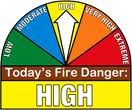
Seivert says also, when someone has the need to burn a pile of brush, debris, or buildings, they are asked to contact the Emergency Management Agency at 755-2124. The dispatchers will obtain the location and nature of the planned burn and will provide the caller with the Fire Chiefs contact information. Through this expanded communication process, we have found some burns can be rescheduled to a different time of day, where wind and moistures are more acceptable. The Fire Chiefs can have input as to how the burn can be conducted safely and be aware of the activity should it become unmanageable.


