
Today: Sunny & breezy. High near 46. S/SW winds @ 10-20 mph w/gusts to near 30. Wind chill values as low as 5 early.
Tonight: Partly cloudy, with a low around 24. S/SW wind 5 to 10 mph.
Tomorrow: Sunny, with a high near 53. S/SW @ 5-10.
Tom. Night: Partly cloudy, with a low around 37.
Friday: Partly sunny, with a high near 60.
Friday Night: Mostly cloudy, with a low around 34.
Saturday: Partly sunny, with a high near 59.
Tuesday’s High in Atlantic was 37. Our Low this morning was 14. Last year on this date the High in Atlantic was 78 and the Low was 32. The Record High on this date in Atlantic, was 78 in 1933 & 2022. The Record Low was 10 in 1895. Sunrise… 7:52. Sunset….6:15.
Today: Sunny & windy. High near 34. NW winds 15-35 mph. Wind chill values as low as 10.
Tonight: Mostly clear, with a low around 16. NW @ 5-10 becoming light & variable. Wind chill values as low as 5.
Tomorrow: Sunny & breezy. High near 47. S @ 10-20 w/gusts to near 30. Wind chill values as low as 5 early.
Thursday: Mostly sunny, with a high near 51.
Friday: Partly sunny, with a high near 61. Breezy.
Monday’s High in Atlantic was 42. Our Low was 19. Last year on this date the High in Atlantic was 70 and the Low was 29. The Record High on this date in Atlantic, was 83 in 1950 & 1953. The Record Low was 11 in 1954. Sunrise… 7:49. Sunset….6:16.
Today: Sunny, with a high near 41. West southwest wind 5- to 15-mph, with gusts as high as 20 mph.
Tonight: Mostly clear, with a low around 21. SW winds 15-to 30-mph. Wind chill values as low as 10. .
Tomorrow: Mostly sunny & windy, with a high near 35. NW @ 15-30 mph. Wind chill values as low as 5.
Wednesday: Mostly sunny & breezy, with a high near 46.
Thursday: Mostly sunny, with a high near 51.
Sunday’s High in Atlantic was 39. Our Low this morning, 21. Last year on this date the High in Atlantic was 65 and the Low was 29. The Record High on this date in Atlantic, was 84 in 1950. The Record Low was 1 in 1925. Sunrise… 7:49. Sunset….6:16.
Today: Scattered snow showers, mainly before 1pm. Cloudy, with a high near 36. North wind 11 to 14 mph, with gusts as high as 20 mph. Chance of precipitation is 50%. Total daytime snow accumulation of less than a half inch possible.
Tonight: Cloudy during the early evening, then gradual clearing, with a low around 18. Northwest wind 7 to 10 mph.
Monday: Sunny, with a high near 40. West northwest wind 7 to 11 mph.
Monday Night: Mostly clear, with a low around 20. Blustery, with a southwest wind 8 to 16 mph becoming northwest after midnight. Winds could gust as high as 25 mph.
Tuesday: Mostly sunny, with a high near 35. Windy, with a north northwest wind 16 to 21 mph, with gusts as high as 29 mph.
Tuesday Night: Mostly clear, with a low around 17.
Wednesday: Mostly sunny, with a high near 47. Breezy.
Saturday’s High in Atlantic was 36. Our Low this morning, 29. Last year on this date the High in Atlantic was 69 and the Low was 26. The Record High on this date in Atlantic, was 91 in 1937. The Record Low was 8 in 1895.
AMES, Iowa – Oct. 16, 2023 – There’s an unmistakable chill in the air as fall slowly creeps into winter. Keeping roads in their best shape to ensure you get where you want to go, no matter the season is our goal at the Iowa Department of Transportation. As the weather changes, our focus is keeping the roads as clear as possible and giving you the information you need to make smarter, safer travel decisions.
What you can do to prepare for the months ahead
Winterize your vehicle – To minimize the possibility of a breakdown, get your vehicle tuned up. Check your vehicle’s wipers, hoses, battery, alternator, belts, tires, brakes, exhaust system, lights, and fluid levels. Make sure your vehicle’s heater and defroster are in good working order and you travel with plenty of gas in your tank. A breakdown is frustrating on a good day but can be dangerous during wintery weather.
Place a winter survival kit in your vehicle – This kit should contain items to help sustain your life and the lives of your passengers should your vehicle become stranded during inclement weather. These items can include booster cables; a flashlight with fresh batteries; extra blankets and warm clothes; nonperishable, high-calorie food items; candles, matches, and a can for melting snow for drinking water; and a snow shovel. Sufficient supplies should be in the kit for all persons traveling in the vehicle. Carrying a mobile phone and charger in your vehicle is also advised for use during an emergency.
Use technology to help make better travel decisions – The winter road conditions layer is now visible on www.511ia.org. This layer, along with layers that show images directly from the windshields of our snowplows and stationary cameras along the roadside, can help you determine whether it is safe to travel now or if you should postpone your trip.
Kick your winter driving skills into gear – The first snowfall and slick roads are a quick reminder that it’s time to re-evaluate and adjust your driving behaviors.
How the Iowa DOT has prepared
Our people and equipment – The department’s 101 maintenance garages employ 1,069 full-time equipment operators, mechanics, and supervisors, and are in the process of hiring up to 633 temporary employees this winter season, to keep the agency’s 902 trucks, 42 motor graders, 33 tow plows, and 10 heavy-duty, self-propelled snowblowers on the road during winter weather.
For those interested in temporary, part-time snowfighter positions, go to https://iowadot.gov/careers and click on the “seasonal/temp” tab.
The materials we use – The Iowa DOT has spent the warmer months stocking salt in our storage facilities for use during the winter. Buying during the spring and summer allows us to obtain better pricing because demand is low. On average, the Iowa DOT uses more than 136,000 tons of salt and nearly 32 million gallons of brine each year to help maintain safe travel on the primary highway system, consisting of interstate, U.S., and Iowa routes.
The Iowa DOT primarily uses salt brine, a simple solution of standard rock salt and water, to help with winter roadway maintenance. It can be used to pretreat roadways before a storm, thus preventing snow and ice from bonding to the pavement. Brine is also used to prewet salt before it leaves the truck, increasing its ability to melt snow and ice and helping keep it on the roadway surface.
You may wonder why Iowa DOT trucks sometimes spray brine on sunny days. Frost is a major safety factor this time of year. The Iowa DOT’s proactive approach of spraying brine on areas prone to frost prevents the formation of an icy layer, which typically occurs on cold, clear nights. Frost is hard to see on the road’s surface and most people don’t expect it. These unexpected encounters with a frost-covered bridge or roadway can be particularly treacherous when traveling at higher rates of speed, making it more difficult to maintain control of your vehicle.
For more information about winter preparedness and the Iowa DOT’s snow and ice control program, check the Iowa DOT’s winter safety website.
Early this morning: A chance of showers and thunderstorms. Cloudy, with a low around 39. Breezy, with a north northwest wind around 18 mph, with gusts as high as 26 mph. Chance of precipitation is 40%. New rainfall amounts of less than a tenth of an inch, except higher amounts possible in thunderstorms.
Today: A 10 percent chance of showers before 7am. Cloudy, then gradually becoming mostly sunny, with a temperature falling to around 37 by 10am. Breezy, with a north northwest wind 16 to 20 mph, with gusts as high as 29 mph.
Tonight: Partly cloudy, with a low around 27. North wind 8 to 10 mph. **FREEZE WARNING IN EFFECT**
Saturday: A chance of snow before 1pm, then a chance of rain and snow. Mostly cloudy, with a high near 38. North northeast wind 8 to 11 mph. Chance of precipitation is 40%. Little or no snow accumulation expected.
Saturday Night: A chance of rain and snow before 4am, then a chance of snow. Cloudy, with a low around 26. North wind around 11 mph, with gusts as high as 18 mph. Chance of precipitation is 50%. New snow accumulation of less than a half inch possible.
Sunday: A 40 percent chance of snow before 1pm. Cloudy, with a high near 35.
Monday: Sunny, with a high near 39.
Thursday’s High in Atlantic was 71 The Low was 38. Rainfall in Atlantic amounted to .14″. Last year on this date (Oct. 27), the High in Atlantic was 59 and the Low was 28. The All-Time Record High was 87 in 1922. The Record Low was 9 in 1997. Sunrise is 7:46. Sunset is 6:22.
National Weather Service Des Moines IA
305 AM CDT Fri Oct 27 2023
…FREEZE WARNING IN EFFECT FROM 11 PM THIS EVENING TO 10 AM CDT SATURDAY…
* WHAT…Sub-freezing temperatures from 27 to 31 degrees.
* WHERE…Much of Central and Southern Iowa.
* WHEN…From 11 PM this evening to 10 AM CDT Saturday.
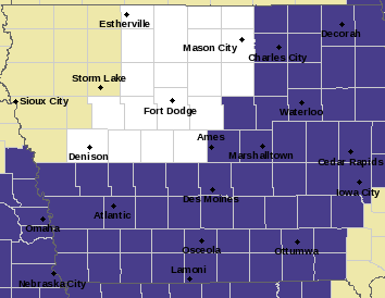
Freeze Warning for counties shaded in purple.
* IMPACTS…Frost and freeze conditions will kill crops, other sensitive vegetation and possibly damage unprotected outdoor plumbing.
* ADDITIONAL DETAILS…This will likely bring an end to the growing season for the rest of central Iowa.
PRECAUTIONARY/PREPAREDNESS ACTIONS…
Take steps now to protect tender plants from the cold. To prevent freezing and possible bursting of outdoor water pipes they should be wrapped, drained, or allowed to drip slowly. Those that have in-ground sprinkler systems should drain them and cover above- ground pipes to protect them from freezing.


