
The National Weather Service has cancelled the Flash Flood Watch for most of the KJAN listening area. The watch was in effect until 10-a.m. And, the Flash Flood Watch for Adams-Union-Taylor-and Ringgold Counties has been scaled back to end at 10-a.m. instead of 1-p.m. today.
A Flood Warning continues until 2-p.m. for northern Guthrie County.
The Freese-Notis (podcast) weather forecast for Atlantic & the KJAN listening area, and weather information for Atlantic.

Podcast: Play in new window | Download (1.5MB)
Subscribe: RSS
**FLASH FLOOD WATCH in effect until 10-a.m.**
Early This Morning: Thunderstorms. Some thunderstorms may produce heavy rainfall. Southeast wind 5 to 10 mph. Chance of thunderstorms 90 percent.
Today: Mostly cloudy. Scattered thunderstorms in the morning… Then isolated thunderstorms in the afternoon. Some thunderstorms may produce heavy rainfall through mid morning. High around 80. North wind near 5 mph increasing to 5 to 15 mph in the afternoon. Chance of thunderstorms 50 percent.
Tonight: Mostly cloudy with a 20 percent chance of thunderstorms through midnight…then partly cloudy after midnight. Cooler. Low in the mid 50s. North wind 5 to 10 mph.
Wednesday: Sunny. High in the upper 70s. East wind around 5 mph.
Wednesday Night: Partly cloudy. A slight chance of showers and isolated thunderstorms after midnight. Low in the mid 50s. South wind near 5 mph. Chance of precipitation 20 percent.
Thursday: Partly sunny with a chance of showers and isolated thunderstorms. High in the upper 70s. Southwest wind 5 to 10 mph. Chance of precipitation 30 percent.
Thursday Night: Mostly cloudy with a 20 percent chance of thunderstorms. Low in the mid 50s.
Friday: Partly sunny with a 20 percent chance of thunderstorms. High around 70.
THE NATIONAL WEATHER SERVICE IN DES MOINES  HAS EXTENDED THE

* FLOOD WARNING FOR...
  NORTHERN GUTHRIE COUNTY IN WEST CENTRAL IOWA...

* UNTIL 200 PM CDT TUESDAY

* AT 143 AM CDT...SEVERAL AREAS ACROSS NORTHERN GUTHRIE COUNTY
  REMAIN AFFECTED BY FLOODING.  HIGHWAY 141 JUST WEST OF BAGLEY AND
  QUAIL ROAD NORTH AND SOUTH OF HIGHWAY 141 REMAIN CLOSED. 165TH
  STREET THROUGH SPRINGBROOK STATE PARK ALSO REMAINS CLOSED.
  NUMEROUS GRAVEL ROADS THROUGHOUT NORTHERN GUTHRIE COUNTY REMAIN
  CLOSED. THIS IS DUE TO THE 6 TO 7 INCHES OF RAIN THAT FELL OVER
  THE AREA SUNDAY NIGHT.  THERE REMAINS THE POSSIBILITY OF
  ADDITIONAL RAINFALL THROUGH MID MORNING ON TUESDAY WHICH MAY
  ENHANCE CURRENT FLOODING OR LEAD TO RENEWED FLASH FLOODING.

* SOME LOCATIONS THAT WILL EXPERIENCE FLOODING INCLUDE...
  LAKE PANORAMA...BAYARD...BAGLEY...YALE...JAMAICA...SPRINGBROOK
  STATE PARK AND LAKIN SLOUGH GAME MANAGEMENT AREA.

PRECAUTIONARY/PREPAREDNESS ACTIONS...

A FLOOD WARNING MEANS THAT FLOODING IS IMMINENT OR HAS BEEN REPORTED.
STREAM RISES WILL BE SLOW AND FLASH FLOODING IS NOT EXPECTED.
HOWEVER...ALL INTERESTED PARTIES SHOULD TAKE NECESSARY PRECAUTIONS
IMMEDIATELY.

DO NOT DRIVE YOUR VEHICLE INTO AREAS WHERE THE WATER COVERS THE
ROADWAY. THE WATER DEPTH MAY BE TOO GREAT TO ALLOW YOUR CAR TO CROSS
SAFELY. MOVE TO HIGHER GROUND.
CRAWFORD-CARROLL-GREENE-AUDUBON-GUTHRIE-CASS COUNTIES…FLASH FLOOD WATCH NOW IN EFFECT UNTIL 10 AM CDT THIS MORNING; ADAIR-ADAMS-DALLAS-MADISON-UNION-TAYLOR AND RINGGOLD COUNTIES….FLASH FLOOD WATCH IN EFFECT UNTIL 1-P.M. TUESDAY.
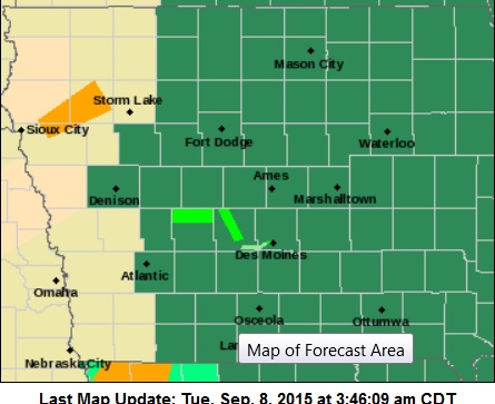
Flash Flood Watch for Counties in Dark Green; Light Green indicates a Flood Warning in effect.
THUNDERSTORMS WITH HEAVY RAINS ARE EXPECTED AGAIN EARLY THIS MORNING…ESPECIALLY BETWEEN 3 AND 7 AM. RAINFALL RATES OF ONE TO TWO INCHES PER HOUR WILL BE COMMON. RAINFALL TOTALS OF 1 TO 3 INCHES WITH LOCALIZED TOTALS OF 4 INCHES ARE AGAIN POSSIBLE WITH THE STRONGER THUNDERSTORMS. WITH SOILS ALREADY SATURATED IN MANY AREAS…FLASH FLOODING MAY QUICKLY REDEVELOP.
* THE HEAVY RAINFALL MAY LEAD TO FLASH FLOODING DUE TO RAPID RISES ALONG SMALL STREAMS AND CREEKS. SIGNIFICANT URBAN PONDING AND WATER FLOWING OVER RURAL ROADS MAY ALSO OCCUR. VERY SERIOUS FLASH FLOODING MAY DEVELOP…OR REDEVELOP IN LOCATIONS THAT HAVE ALREADY SEEN TORRENTIAL RAINS SUNDAY NIGHT.
MILLS-MONTGOMERY-FREMONT-PAGE COUNTIES…
234 AM CDT TUE SEP 8 2015
…FLASH FLOOD WATCH IS CANCELLED…
THE FLASH FLOOD WATCH FOR PORTIONS OF SOUTHWEST IOWA AND NEBRASKA HAS BEEN CANCELLED. A FEW LOCATIONS IN SOUTHEAST NEBRASKA AND SOUTHWEST IOWA MAY RECEIVE RAINFALL TOTALS OF 1 TO 2 INCHES OR MORE…BUT HEAVY RAINFALL AMOUNTS ARE NOT WIDESPREAD…AND RAINFALL RATES HAVE BEEN MODERATE. THE THREAT OF FLASH FLOODING HAS DIMINISHED IN THE AREA.
DES MOINES, Iowa (AP) — Another round of heavy rain could develop Monday night generating renewed concerns of flash flooding in the southern half of the state. The National Weather Service in Des Moines says many of the same areas that received heavy rain Sunday could be in the bullseye for another round Monday. A flash flood watch was in effect through Tuesday morning for a large portion of central and south-central Iowa.
Weather service forecaster says thunderstorms with heavy rain are expected between 9 p.m. Monday and 4 a.m. Tuesday. Rainfall rates of 1 to 3 inches per hour may be common with localized totals of 5 inches possible. With soil already saturated flash flooding could quickly develop. Some storms south of U.S. Highway 34 could produce hail and damaging wind.
Flash Flood Watch and Warnings continue for the KJAN listening area.
The National Weather Service says a Flash Flood Watch remains in effect this evening from 7 o’clock through 7-a.m. Tuesday, for the following counties in the KJAN listening area: Cass-Adair-Adams-Audubon-Guthrie-Crawford-Carroll-Fremont-Madison-Mills-Montgomery-and Page.
Rainfall totals of 1-3 inches are possible, with localized 5-inch downpours possible. A Flash Flood Watch means conditions may develop that lead to flash flooding, which may occur quickly in areas where the soil is already saturated. Be prepared to take action if a Flash Food Warning is issued.
A Flood Warning remains in effect until 2-a.m. Tuesday, for northern Audubon and Guthrie Counties, along with southeast Carroll County, in our listening area.


