
Early This Morning: Clear…colder. Northwest wind 5 to 10 mph.
Today: Sunny. High in the lower 70s. Northwest wind 5 to 15 mph.
Tonight: Mostly clear. Low in the mid 40s. Northwest wind near 5 mph.
Wednesday: Sunny. High in the upper 60s. Northwest wind around 5 mph.
Wednesday Night: Partly cloudy. Low in the upper 40s. South wind near 5 mph.
Thursday: Mostly sunny. High around 70. West wind 5 to 10 mph shifting to the northwest 10 to 15 mph with gusts to around 25 mph in the afternoon.
Thursday Night: Partly cloudy. Colder. Low in the upper 30s.
Friday: Sunny…cooler. High in the upper 50s.
Atlantic Fire Chief Mark McNees reports Cass County Fire Chiefs have been discussing a possible Burn Ban for Cass County. The Chiefs contacted Cass County Emergency Management Director Mike Kennon, after receiving some concerns by local residents. McNees says at this time, the overall consensus is to remind residents that conditions today (Monday) are very dangerous and ANY open burning should not be conducted. All precautions should be taken by farmers harvesting their crops to clean and maintain their equipment to help prevent equipment fires that could easily result in a large out of control field fire.
Atlantic Chief Mark McNees says also, “ At this moment it seems to be a typical fall harvest season with a large fuel load of unharvested crops. However, there are still reasonably green areas surrounding fields and some areas that are fairly wet in parts of the county. At the current pace, and with the two week outlook in the forecast, it appears much of the harvest will be completed within 2 to 3 weeks. I would not encourage any open burning until later in the fall or early winter when the crops are out and there may have been some more precipitation. It would be best to wait as long as possible. If conditions worsen greatly a ban may be issued and residents will be advised.”
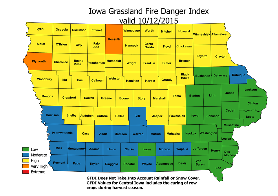
Grassland Fire Danger Index 10/12/15
It is best always to contact your local fire department chief before any burns are conducted to get their advice and to give notice that a burn is being planned. Cass County has been very successful the past few years in keeping wildland fires from occurring by communicating with residents in this regard.
McNees added, “Several area departments have specifically trained to conduct prescribed burns for CRP mid management burns, and have instituted programs to do other planned, controlled burns for landowners in their districts. This provides a much safer and timely outcome for everyone. Fire departments can train, plan, and conduct land burns at times when they have personnel, and landowners benefit from the control of such burns.”
Landowners are encouraged to contact their departments now if they would like to discuss such burns, including the timing, areas, and costs. McNees says “ last year Atlantic began a program for prescribed burns and it became difficult to get them all done when several waited until late to make requests. Departments want to stay within their districts, but will aid neighboring departments if necessary, which is another reason to contact your department to see if they have such a program instituted and can assist the landowner.”
Today: WIND ADVISORY 10-am to 6-pm; Partly Cloudy & windy. High near 70. NW @ 20-35mpg w/gusts to near 45.
Tonight: Mo. Clear & breezy. Low around 35. NW @ 15-25.
Tuesday: P/Cldy. High near 70. SE @ 5-10.
Tue. Night: Mostly clear, with a low around 46.
Wednesday: P/Cldy. High near 70. N.NW @ 5-10.
Wednesday Night: Partly cloudy, with a low around 46.
Thursday: P/Cldy to Cldy w/a chance of late day shwrs. High 72.
Sunday’s High in Atlantic was 86. Our 24-hour Low ending at 7-a.m. today was 54.
Last year on this date, our High was 59 and the Low was 46.
The All-time Record High in Atlantic on Oct. 12th was 90 in 1899. The All-Time record low was 17 in 1908. Sunrise today is at 7:28, and sunset tonight will take place at 6:44.
Early This Morning: Partly cloudy. Northwest wind 10 to 15 mph.
Today: **WIND ADVISORY from 10-a.m. until 6-p.m.** Sunny…breezy…cooler. High in the lower 70s. Northwest wind 10 to 25 mph increasing to 20 to 25 mph in the afternoon. Gusts up to 45 mph.
Tonight: Clear…colder. Low in the lower 40s. Northwest wind 5 to 15 mph. Gusts up to 30 mph through midnight.
Tuesday: Sunny. High in the upper 60s. Northwest wind 5 to 10 mph.
Tuesday Night: Mostly clear. Low in the upper 40s. Southwest wind near 5 mph shifting to the west around 5 mph after midnight.
Wednesday: Sunny. High in the lower 70s. Northwest wind 5 to 10 mph.
Wednesday Night: Partly cloudy. Low in the mid 40s.
Thursday: Mostly sunny. High around 70.
CRAWFORD-CARROLL-AUDUBON-GUTHRIE-DALLAS-POLK-CASS-ADAIR-MADISON-ADAMS-UNION COUNTIES (330 AM CDT MON OCT 12 2015): WIND ADVISORY IN EFFECT FROM 10-A.M. TODAY UNTIL 6 PM.
* TIMING…NORTHWEST WINDS WILL INCREASE AFTER SUNRISE…WITH STRONG WINDS INTO THE AFTERNOON. SUSTAINED WINDS OF 25 TO 30 MPH WITH GUSTS OF 45 MPH OR HIGHER. DRIVING WILL BECOME DIFFICULT…ESPECIALLY IN HIGH PROFILE VEHICLES.

Wind Advisory in effect for counties in tan on this map.
A WIND ADVISORY MEANS THAT WINDS OF 30 MPH ARE EXPECTED OR WIND GUSTS TO 45 MPH OR HIGHER ARE EXPECTED. WINDS THIS STRONG CAN MAKE DRIVING DIFFICULT…ESPECIALLY FOR HIGH PROFILE VEHICLES. USE EXTRA CAUTION.
331 AM CDT SUN OCT 11 2015
…NEAR RECORD HIGHS TODAY…
EARLY THIS MORNING…CLEAR…WARMER. SOUTH WIND 5 TO 10 MPH.
TODAY…SUNNY…BREEZY. HIGH IN THE MID 80S. SOUTH WIND 5 TO 15 MPH INCREASING TO 15 TO 20 MPH IN THE AFTERNOON.
TONIGHT…MOSTLY CLEAR. LOW IN THE MID 50S. SOUTHWEST WIND 10 TO 15 MPH SHIFTING TO THE NORTHWEST AFTER MIDNIGHT. GUSTS UP TO 25 MPH.
COLUMBUS DAY…SUNNY…BREEZY…COOLER. HIGH IN THE UPPER 60S. NORTHWEST WIND 15 TO 25 MPH WITH GUSTS TO AROUND 40 MPH.
MONDAY NIGHT…CLEAR…COLDER. LOW IN THE LOWER 40S. NORTHWEST WIND 5 TO 15 MPH. GUSTS UP TO 25 MPH THROUGH MIDNIGHT.
TUESDAY…SUNNY. HIGH IN THE LOWER 70S. WEST WIND 5 TO 15 MPH.
TUESDAY NIGHT…MOSTLY CLEAR. LOW IN THE MID 40S.
WEDNESDAY…SUNNY. HIGH IN THE LOWER 70S.
Skyscan Forecast Saturday, October 10, 2015 Chris Parks

Podcast: Play in new window | Download (302.6KB)
Subscribe: RSS
EARLY THIS MORNING: MOSTLY CLOUDY. COOLER. LOW IN THE UPPER 40S. NORTH WIND 5 TO 10 MPH.
TODAY: MOSTLY SUNNY. COOLER. HIGH IN THE MID 60S. NORTH WIND 5 TO 10 MPH.
TONIGHT: MOSTLY CLEAR. LOW IN THE MID 40S. NORTHEAST WIND NEAR 5 MPH SHIFTING TO THE SOUTH AFTER MIDNIGHT.
SATURDAY: SUNNY…WARMER. HIGH IN THE MID 70S. SOUTH WIND 5 TO 15 MPH WITH GUSTS TO AROUND 25 MPH.
SATURDAY NIGHT: MOSTLY CLEAR. WARMER. LOW IN THE MID 50S. SOUTH WIND 5 TO 10 MPH.
SUNDAY: SUNNY. HIGH IN THE MID 80S.
MONDAY (COLUMBUS DAY): SUNNY…COOLER. HIGH IN THE LOWER 70S.
Today: Partly Cloudy w/isolated showers possible. High 76. Winds becoming NW @ 10-20.
Tonight: Partly-to-Mostly Cloudy. Low 42. NW @ 5-10.
Tomorrow: Mostly Sunny. High 67. N @ 5-10.
Tom. Night: Partly Cloudy. Low around 43.
Saturday: Partly cloudy & breezy. High 78. S/SW winds @ 5-15mph w/gusts to 25. Sat. Night: Mo. Clear. Low 54.
Sunday: Sunny. High around 84.
Wednesday’s High in Atlantic was 77. Our 24-hour Low ending at 7-a.m. today was 54.
Last year on this date, our High was 71, and the Low was 38.
The All-time Record High in Atlantic on Oct. 8th was 93 in 1893. The All-Time record low was 19 in 1908 and 2000. Sunrise today is at 7:24, and sunset tonight will take place at 6:50.
Early This Morning: Mostly cloudy. South wind near 10 mph.
Today: Mostly sunny. High in the upper 70s. Southwest wind 5 to 15 mph shifting to the northwest 10 to 15 mph with gusts to around 25 mph in the afternoon.
Tonight: Mostly cloudy. Cooler. Low in the mid 40s. North wind 5 to 15 mph.
Friday: Mostly sunny. Cooler. High in the lower 60s. North wind 5 to 10 mph.
Friday Night: Partly cloudy. Low in the lower 40s. Northeast wind near 5 mph shifting to the south after midnight.
Saturday: Sunny. High in the lower 70s. South wind 5 to 15 mph with gusts to around 25 mph.
Saturday Night: Mostly clear. Warmer. Low in the mid 50s.
Sunday: Sunny…warmer. High in the lower 80s.


