
Early This Morning: Mostly clear. Patchy fog. East wind near 5 mph.
Today: Patchy fog through mid morning. Partly sunny until late afternoon…then cloudy with a 20 percent chance of rain late in the afternoon. High in the mid 50s. South wind 5 to 15 mph.
Tonight: Not as cool. Rain likely in the evening…then periods of rain before midnight and early morning. Rain likely early in the morning. Low in the mid 40s. South wind 5 to 10 mph. Chance of rain 80 percent.
Saturday: Cloudy with a chance of rain through mid morning…then cloudy with a slight chance of rain before noon. Mostly sunny in the afternoon. High in the upper 50s. Southwest wind 5 to 10 mph. Chance of rain 50 percent.
Sunday: Sunny…warmer. High around 70. Southwest wind 5 to 15 mph.
Monday: Mostly sunny. High in the lower 70s.
Today: Clear to Partly Cloudy & breezy. High 52. NW winds @ 15-25 this morning diminishing this afternoon.
Tonight: Mostly clear, with a low around 28.
Friday: Increasing cloudiness w/a slight chance of rain in the afternoon. High 56. S @ 5-10.
Friday Night: Rain likely. Low around 43.
Saturday: Mostly Cloudy w/rain ending in the morning. High 72. S-W winds 5-10.
Saturday Night: Mostly clear, with a low around 41.
Sunday: Sunny, with a high near 68.
Wednesday’s High in Atlantic was 49. Our 24-hour Low ending at 7-a.m. today was 32. Last year on this date, our High was 55 and the Low was 27. The All-time Record High in Atlantic on Oct. 29th was 91 in 1937. The All-Time record low was 8 in 1895. Sunrise today is at 7:48, and sunset tonight will take place at 6:19.
Early This Morning: Mostly clear. Colder. West wind 10 to 15 mph with gusts to around 25 mph.
Today: Mostly sunny. High around 50. Northwest wind 10 to 15 mph with gusts to around 25 mph.
Tonight: Mostly clear. Low in the lower 30s. Northwest wind near 5 mph shifting to the south after midnight.
Friday: Mostly sunny in the morning…then mostly cloudy with a 20 percent chance of rain in the afternoon. High in the mid 50s. South wind near 10 mph.
Friday Night: Rain likely. Not as cool. Low in the lower 40s. South wind 5 to 10 mph. Chance of rain 70 percent.
Saturday: Cloudy with a 30 percent chance of rain in the morning… Then mostly sunny in the afternoon. High in the upper 50s. South wind around 5 mph shifting to the west in the afternoon.
Saturday Night: Partly cloudy. Low in the lower 40s.
Sunday: Sunny. High in the upper 60s.
Today: Areas of drizzle and fog before 9am. Cloudy to P/Cldy & windy. High 50. NW @ 20-40mph
Tonight: Clear to P/Cldy & breezy. Low around 32. W/NW @ 10-20.
Tomorrow: P/Cldy & breezy. High near 57. W/NW @ 10-20.
Tom. Night: Mostly clear, with a low around 31.
Friday: Partly Cloudy to Cloudy. High near 58
Fri. Night: Cloudy w/a 70% chance of rain. Low around 43.
Saturday: Mo. Cldy w/a 30% chance of rain. High near 89.
The 24-hour High temperature in Atlantic ending at 7-a.m. today, was 48. The 24-hour Low was 44. We received .37” of rain yesterday through early this morning. Last year on this date, we reached 56 for a High, and 28 was our Low. The All-time record High for Atlantic on Oct. 28th was 83 in 1922. The record Low was 2 in 1925. Sunrise today is at 7:46. Sunset will be at 6:20.
Early this morning: Areas of drizzle and fog. Cloudy, with a low around 45. West northwest wind around 13 mph.
Today: Areas of drizzle and fog before 9am. Cloudy, then gradually becoming mostly sunny, with a steady temperature around 47. Windy, with a northwest wind 16 to 24 mph, with gusts as high as 34 mph.
Tonight: Mostly clear, with a low around 32. Breezy, with a west northwest wind 14 to 16 mph, with gusts as high as 23 mph.
Thursday: Sunny, with a high near 50. Breezy, with a west northwest wind 11 to 17 mph, with gusts as high as 25 mph.
Thursday Night: Mostly clear, with a low around 31. Northwest wind around 5 mph becoming calm in the evening.
Friday: Partly sunny, with a high near 56.
Friday Night: Rain likely. Cloudy, with a low around 43. Chance of precipitation is 70%.
Saturday: A 30 percent chance of rain. Partly sunny, with a high near 59.
POTTAWATTAMIE-MILLS-MONTGOMERY-FREMONT-PAGE COUNTIES…

Freeze Watch for Counties in aqua color
THE NATIONAL WEATHER SERVICE IN OMAHA/VALLEY HAS ISSUED A FREEZE WATCH, WHICH IS IN EFFECT FROM 1-A.M. THROUGH 9-A.M THURSDAY.
* TEMPERATURE…SEVERAL HOURS OF TEMPERATURES AT OR BELOW 32 DEGREES ARE EXPECTED LATE WEDNESDAY NIGHT INTO THURSDAY MORNING.
* IMPACTS…TENDER VEGETATION MAY BE DAMAGED IF PRECAUTIONS ARE NOT TAKEN.
PRECAUTIONARY/PREPAREDNESS ACTIONS… A FREEZE WATCH MEANS SUB-FREEZING TEMPERATURES ARE POSSIBLE. THESE CONDITIONS COULD KILL CROPS AND OTHER SENSITIVE VEGETATION.
Today: Cloudy w/a 50% chance of showers. High near 53. E/SE winds 10-15mph. New precipitation amounts between a quarter and half of an inch possible.
Tonight: Cloudy w/a 60% chance of rain until about midnight. Low around 44. NW winds 15-25. New precipitation amounts between a tenth and quarter of an inch possible.
Wednesday: Cloudy to P/Cldy w/a chance of sprinkles in the morning. High near 49. W/NW winds @ 20-40mph.
Wed. Night: Mostly clear, with a low around 31. W/NW @ 10-20.
Thursday: P/Cldy & breezy. High near 53. W/NW @ 10-20 w/gusts to 25.
Friday: P/Cldy to Cldy w/a slight chance of rain in the afternoon. High around 58.
Monday’s High in Atlantic was 62. Our 24-hour Low ending at 7-a.m. today was 31. Last year on this date, our High was 71 and the Low was 42. The All-time Record High in Atlantic on Oct. 27th was 87 in 1922. The All-Time record low was 9 in 1994. Sunrise today is at 7:46, and sunset tonight will take place at 6:22.
Early This Morning: Cloudy. East wind 5 to 15 mph.
Today: Cloudy. A slight chance of showers through mid morning… Then a chance of showers in the late morning and early afternoon. A chance of rain late in the afternoon. High in the mid 50s. East wind 5 to 10 mph. Chance of precipitation 50 percent.
Tonight: Cloudy. A chance of rain until early morning…then a slight chance of rain early in the morning. Low in the mid 40s. Northeast wind near 5 mph shifting to the northwest after midnight. Chance of rain 50 percent.
Wednesday: Mostly cloudy in the morning then becoming mostly sunny. Breezy. High in the lower 50s. Northwest wind 15 to 25 mph with gusts to around 35 mph.
Wednesday Night: Mostly clear. Colder. Low in the lower 30s. Northwest wind 10 to 15 mph with gusts to around 25 mph.
Thursday: Sunny. High in the lower 50s. Northwest wind 10 to 15 mph with gusts to around 25 mph.
Thursday Night: Partly cloudy. Low in the lower 30s.
Friday: Mostly cloudy. A 20 percent chance of rain showers in the afternoon. High in the mid 50s.
The Shelby County Emergency Management Agency reports, with much of the crop being in the bins now, the amount of fuel necessary for opening burning to spread beyond an intended area, has been reduced. Therefore, the local Fire Danger threat is being reduced to “Moderate,” from now through late this week.
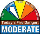 Officials warn that grassland is still very dry, and fires which start there can run for a long time until out of fuel, and spread to structures. Persons are advised to please let your Fire Chief know in advance of the time and location of any burns to prevent needless responses from local volunteer firefighters. The next update will be Thursday October 29, 2015


