
327 AM CST THU DEC 24 2015
A BURST OF MODERATE SNOWFALL WILL COMPLICATE TRAVEL TODAY. A COMPACT BUT INTENSE STORM SYSTEM WILL CROSS IOWA TODAY, CAUSING SNOW TO FALL FAIRLY HEAVILY FOR A FEW HOURS WITH MODERATE ACCUMULATIONS RESULTING. THIS WILL MAKE TRAVEL HAZARDOUS AT TIMES AS VISIBILITY WILL DROP RAPIDLY AND ROADS WILL BECOME SNOW COVERED.
AREA COUNTIES: SAC-CRAWFORD-CARROLL-AUDUBON-GUTHRIE-DALLAS-CASS-ADAIR…
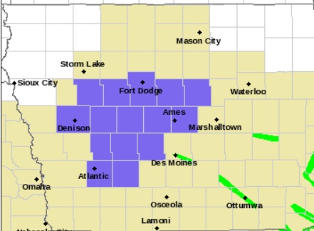
Winter Weather Advisory for Counties shaded in purple.
THE NATIONAL WEATHER SERVICE IN DES MOINES HAS ISSUED A WINTER WEATHER ADVISORY FOR SNOW…WHICH IS IN EFFECT FROM 8 AM THIS MORNING TO 6 PM CST THIS EVENING.
THE HEAVIEST SNOW WILL REACH WESTERN IOWA BY AROUND 8 AM…AND END OVER NORTH CENTRAL IOWA DURING THE AFTERNOON. STORM TOTAL SNOW ACCUMULATIONS OF 2 TO 3 INCHES ARE LIKELY. WINDS WILL BE LIGHT BUT VISIBILITY WILL DROP RAPIDLY TO A MILE OR LESS IN THE HEAVIER SNOW.
TRAVEL CONDITIONS WILL DETERIORATE RAPIDLY AS THE SNOW MOVES IN, WITH VISIBILITY DROPPING RAPIDLY FROM WEST TO EAST BETWEEN MID MORNING AND AROUND MIDDAY. ROADS WILL ALSO BECOME SNOW COVERED AND SLICK. PLEASE RECONSIDER OR ADJUST YOUR TRAVEL PLANS ACCORDINGLY.
PRECAUTIONARY/PREPAREDNESS ACTIONS…
A WINTER WEATHER ADVISORY FOR SNOW MEANS THAT PERIODS OF SNOW WILL CAUSE PRIMARILY TRAVEL DIFFICULTIES. BE PREPARED FOR SNOW COVERED ROADS AND LIMITED VISIBILITIES…AND USE CAUTION WHILE DRIVING.
AREA COUNTIES: GUTHRIE-DALLAS-ADAIR-MADISON-UNION-RINGGOLD
303 PM CST WED DEC 23 2015
…STRONG WINDS EXPECTED THROUGH 5 PM…
A STORM SYSTEM OVER SOUTHEAST IOWA WILL CONTINUE TO LIFT TO THE NORTHEAST THROUGH EARLY EVENING. STRONG NORTHERLY WINDS ON THE BACKSIDE OF THIS SYSTEM WILL MOVE ACROSS THE AREA THROUGH THE REMAINDER OF THE AFTERNOON. EXPECT SUSTAINED WIND SPEEDS OF 20 TO 30 MPH WITH GUSTS BETWEEN 30 AND 40 MPH. IN ADDITION… COLDER AIR SPILLING INTO THE AREA WILL CHANGE THE RAIN TO SNOW OR A RAIN/SNOW MIX. SNOW MAY ACCUMULATE ON GRASSY AREAS BUT ROADWAYS WILL BE WET TO SLUSHY. USE EXTRA CAUTION DURING THE EVENING COMMUTE. SLOW DOWN AND ALLOW EXTRA TIME TO REACH YOUR DESTINATION.
There are several reports of vehicles in the ditches, median and minor collisions this afternoon in the KJAN listening area. Most of the accidents appear to be happening along Interstate 80 in Cass and Adair Counties. The Iowa DOT’s road conditions website at 511ia.org shows roads in and around Atlantic are partially covered with snow, ice and slush. I-80 from about Highway 173 in Cass County to Highway 25 in Adair County is also slushy. Slow down, and allow extra travel time to reach your destination.
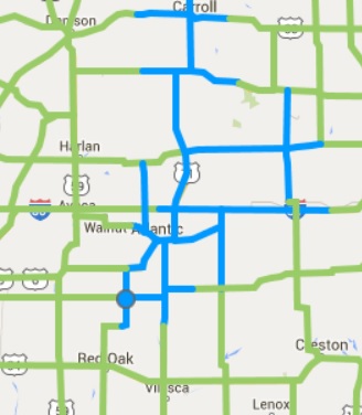
Roads in blue are partially covered in snow and slush. Bridges and overpasses may be icy. (Image as of 2:30-p.m. 12/23)
Today: Cloudy w/rain becoming mixed with & changing to snow this afternoon. High (early) in the Low 40’s w/temps falling into the mid-30’s. NW @ 10-20mph w/gusts to near 30 at times.
Tonight: Cloudy w/mixed precip ending. Low 28. NW @ 10-20. Total New snow accumulation of around 1” is possible.
Thursday: Mo. Cldy w/flurries in the morning. High 35. NW @ 10-20.
Thursday Night: Partly cloudy, with a low around 27.
Christmas Day: Mo. Cldy. High around 40.
Friday Night: A 60% chance of rain or drizzle. Low around 33.
Saturday: Mo. Cldy w/a 40% chance of rain and/or snow. High 44
Tuesday’s High in Atlantic was 44. Our 24-hour ending at 7-a.m. today, was 28. We received .24” of precipitation overnight through 7-a.m. today. Last year on this date we reached 36 for a High and 32 was the low. The All-time Record High in Atlantic on this date was 62 in 1964, while the Record Low was -22 in 1983.
Early This Morning: Rain. Not as cool. Southeast wind 5 to 10 mph. Chance of rain 90 percent.
Today: Rain in the morning…then a chance of light rain in the afternoon. High in the lower 40s. Northeast wind 5 to 10 mph shifting to the northwest 10 to 15 mph with gusts to around 25 mph in the afternoon. Chance of rain near 100 percent.
Tonight: Partly cloudy through midnight…then mostly cloudy with a 20 percent chance of light snow after midnight. Colder. Low in the upper 20s. West wind 5 to 10 mph.
Thursday: Mostly cloudy. A 20 percent chance of light snow in the morning. High in the mid 30s. West wind 5 to 10 mph.
Thursday Night: Partly cloudy. Low in the upper 20s. South wind around 5 mph.
Christmas Day: Mostly cloudy. A 20 percent chance of light rain in the afternoon. High in the lower 40s. Southeast wind 5 to 15 mph.
Friday Night: Cloudy with a 50 percent chance of rain. Low in the mid 30s.
Saturday: Cloudy with a 30 percent chance of rain. High in the upper 30s.
Today: Areas of dense fog this morning; Mostly Cloudy. High near 46. S @ 10-20.
Tonight: Cloudy w/light rain. Low around 38. S @ 10-15.
Wednesday: Cloudy w/rain in the morning becoming mixed with light snow. High near 40 w/temps slowly declining during the afternoon into the 30’s.
Wednesday Night: Mostly cloudy, with a low around 27.
Thursday: Cloudy to Partly Cloudy w/a chance of flurries. High 35
Christmas Eve: Partly cloudy, with a low around 29.
Christmas Day: A slight chance of rain and snow before noon, then a slight chance of rain. Mostly cloudy, with a high near 44.
Monday’s High in Atlantic was 31. Our 24-hour ending at 7-a.m. today, was 25. We received a trace of precipitation Monday, in the form of drizzle and mist.
Last year on this date we reached 42 for a High and 32 was the low. The All-time Record High in Atlantic on this date was 65 in 1933, while the Record Low was -27 in 1989.
SAC-CRAWFORD-CARROLL-AUDUBON-GUTHRIE-CASS-ADAIR-ADAMS-UNION-TAYLOR-RINGGOLD COUNTIES…
635 AM CST TUE DEC 22 2015
…PATCHY DENSE FOG MAY LEAD TO SLICK ROADS THIS MORNING…
FOG HAS DEVELOPED OVER PORTIONS OF WESTERN AND SOUTHERN IOWA THIS MORNING WITH VISIBILITIES DROPPING TO A QUARTER TO A HALF OF A MILE IN SPOTS. THIS FOG COMBINED WITH SUB FREEZING PAVEMENT
TEMPERATURES MAY LEAD TO SLICK SPOTS ON ROADS THROUGH MID
MORNING…ESPECIALLY ALONG AND NORTH OF INTERSTATE 80. IF YOU
ENCOUNTER ANY FOG…PLEASE LEAVE PLENTY OF SPACE BETWEEN YOU AND THE DRIVER AHEAD OF YOU AND BE PREPARED FOR ANY SLICK AREAS.
EARLY THIS MORNING…CLOUDY. AREAS OF FOG. SOUTH WIND 5 TO 10 MPH.
TODAY…CLOUDY…BREEZY…WARMER. PATCHY FOG THROUGH MID MORNING. HIGH IN THE MID 40S. SOUTH WIND 10 TO 20 MPH WITH GUSTS TO AROUND 30 MPH.
TONIGHT…CLOUDY. NOT AS COOL. A SLIGHT CHANCE OF LIGHT RAIN BEFORE MIDNIGHT. A CHANCE OF LIGHT RAIN AFTER MIDNIGHT…THEN LIGHT RAIN LIKELY EARLY IN THE MORNING. LOW IN THE UPPER 30S. SOUTH WIND 5 TO 15 MPH. CHANCE OF RAIN 70 PERCENT.
WEDNESDAY…MOSTLY CLOUDY. RAIN LIKELY IN THE MORNING…THEN A CHANCE OF RAIN EARLY IN THE AFTERNOON. A SLIGHT CHANCE OF RAIN LATE IN THE AFTERNOON. HIGH IN THE LOWER 40S. NORTHWEST WIND 5 TO 15 MPH. CHANCE OF RAIN 70 PERCENT.
THURSDAY…PARTLY SUNNY. HIGH IN THE UPPER 30S. WEST WIND 5 TO 10 MPH.
CHRISTMAS DAY…CLOUDY. A SLIGHT CHANCE OF RAIN AND SNOW IN THE MORNING…THEN A SLIGHT CHANCE OF RAIN IN THE AFTERNOON. HIGH IN THE LOWER 40S. CHANCE OF PRECIPITATION 20 PERCENT.
Today: Cloudy with patchy fog & Light rain or snow possible this morning. High near 35. NW @ 15-25.
Tonight: Mostly cloudy, with a low around 28. Winds light and variable.
Tomorrow: P/Cldy to Cldy. High 48. S @ 10-20.
Tom. Night: Mo. Cldy & breezy, w/a 30% chance of rain after midnight. Low around 37.
Wednesday: Mo. Cldy w/a chance of showers. High 45.
Thursday: Mo. Cldy w/a chance of flurries. High near 35.
Sunday’s High in Atlantic was 48. Our 24-hour ending at 7-a.m. today, was 30.
Last year on this date we reached 41 for a High and 36 was the low. The All-time Record High in Atlantic on this date was 58 in 1941, while the Record Low was -22 in 1989.
Today: Cloudy…colder. Patchy fog through mid morning. High in the upper 30s. West wind 5 to 15 mph.
Tonight: Mostly cloudy in the evening then becoming partly cloudy. Low in the upper 20s. Southwest wind around 5 mph.
Tuesday: Partly sunny. Breezy. High in the upper 40s. South wind 5 to 15 mph increasing to 15 to 20 mph in the afternoon. Gusts up to 30 mph.
Tuesday Night: Mostly cloudy. A 20 percent chance of rain after midnight. Low in the upper 30s. South wind 5 to 15 mph.
Wednesday: Cloudy with a 30 percent chance of rain. High in the upper 40s.
Wednesday Night: Mostly cloudy with a 20 percent chance of rain and snow. Low in the upper 20s.
Thursday: Partly sunny. High in the lower 40s.


