
The National Weather Service (NWS) and local county emergency managers are once again hosting storm spotter training classes across Iowa. There are a combination of “in-person” spotter training classes scattered across the state and webinar-based distance learning classes. In-person spotter training classes are offered primarily in larger cities and towns, but also in several rural counties and smaller towns.
Spotter talks are open to the public on a first come, first serve basis. No prior registration is required. Scheduling usually takes place in January and February, but not every county will have a talk.
In the KJAN listening area, here is the schedule for Storm Spotter classes:
Webinar Storm Spotter Training is being offered on Tue., April 12th and Tue., April 19th, from 7-until 8:30-p.m. at https://join.me/nws-desmoines. Also please call 1-866-231-8384. The webinars are open to all spotters. One “advanced” spotter class is offered and built on what was taught in the regular class. It is intended for those who wish to do mobile spotting and desire a deeper understanding of mesoscale and storm-scale meteorology as it relates to storm spotting. Spotters interested in attending this class should have attended either a regular in-person or webinar-based spotter class.
Today: P/Cldy. NW @ 10-20. High 21
Tonight: Cloudy to P/Cldy. Low around 8. Light & variable winds.
Tomorrow: Mo. Cldy w/light snow. High near 23. NE @ 10.
Tomorrow night: Partly cloudy, with a low around 4.
Thursday: P/Cldy. High near 20.
Thu. Night: A slight chance of snow. Low 16.
Friday: Mo. Cloudy w/flurries. High near 26.
Monday’s High in Atlantic was 23. We received 1-inch of new snow here at the KJAN studios after 7-a.m. for a total of 1.3”. The snow had a liquid value of .07“ precipitation. The 24-hour Low ending at 7-a.m. today was 7. Last year on this date we reached 33 for a High and 27 was the low. The All-time Record High in Atlantic on this date was 59 in 1954, 2000 and 2009. The Record Low was -36 in 1975.
EARLY THIS MORNING…MOSTLY CLOUDY. BREEZY…COLDER. NORTH WIND AROUND 20 MPH WITH GUSTS TO AROUND 30 MPH.
TODAY…MOSTLY SUNNY. BREEZY. HIGH 15 TO 20. NORTHWEST WIND 15 TO 20 MPH WITH GUSTS TO AROUND 30 MPH.
TONIGHT…PARTLY CLOUDY UNTIL EARLY MORNING THEN BECOMING MOSTLY CLOUDY. LOW 5 TO 10 ABOVE. NORTHWEST WIND 5 TO 15 MPH.
WEDNESDAY…MOSTLY CLOUDY. A SLIGHT CHANCE OF LIGHT SNOW THROUGH MID MORNING…THEN A CHANCE OF LIGHT SNOW IN THE LATE MORNING AND EARLY AFTERNOON. A SLIGHT CHANCE OF LIGHT SNOW LATE IN THE AFTERNOON. HIGH 15 TO 20. NORTH WIND AROUND 5 MPH SHIFTING TO THE EAST IN THE AFTERNOON. CHANCE OF SNOW 50 PERCENT.
WEDNESDAY NIGHT…MOSTLY CLOUDY. A 20 PERCENT CHANCE OF LIGHT SNOW THROUGH MIDNIGHT. LOW 5 TO 10 ABOVE. EAST WIND 5 TO 10 MPH.
THURSDAY…PARTLY SUNNY. HIGH IN THE LOWER 20S. EAST WIND 5 TO 10 MPH.
A Blizzard Warning is posted for more than 30 counties across Iowa’s northern half, while much of the rest of the state is under a Winter Weather Advisory. While the term “blizzard” conjures thoughts of deep snow drifts for many Iowans, National Weather Service meteorologist Brad Small says that won’t be the case today.
“People think of blizzards, probably the common definition is associated with a lot of snow,” Small says, “but technically, all it means is that you can’t see where you’re going because of strong winds and low visibilities.” To be a blizzard, winds need to be howling at 35-miles an hour or greater and visibilities need to be at a quarter-mile or less due to blowing snow. Small says new snowfall today will be minimal.
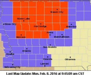
Blizzard Warning for counties in red. Winter Weather and/or Wind Advisories for counties in lavender.
“It’s really difficult to measure,” Small says. “Probably an inch is a very common snow amount so far, of what we’ve seen. The snow amounts are not going to be the problem with this storm. It’s definitely going to be the visibilities, especially in rural and open areas.” Another hazard in this latest weather event is the bitter cold.
“We’ll have wind chills across the state in single digits above and below zero,” Small says. “Conditions will improve later today and into the night but we’ll see lows in the single digits above zero north and maybe around 10 south. Wind chills will be well into the teens below zero toward the Minnesota border by daybreak Tuesday.”
A frosty week is ahead. The forecast calls for low temperatures to remain mostly in the single digits and teens through the weekend, with highs only in the teens and 20s. See more at weather-dot-gov.
(Radio Iowa)
The National Weather Service in Omaha has extended the Wind Advisory which went into effect today at 9-a.m. The Advisory, which had been set to expire at 5-p.m., will now end at 6-p.m. It is in effect for Monona, Harrison, Shelby, Pottawattamie, Mills, Montgomery, Fremont and Page Counties. A Winter Weather Advisory remains in effect until 3-p.m. today for Audubon, Guthrie, Cass, Adair, Adams, Madison, Union, Taylor and Ringgold Counties. And, a Blizzard Warning continues until 3-p.m. for Sac, Crawford and Carroll Counties in the northern part of our listening area.
LIGHT SNOW SHOWERS WILL CONTINUE THROUGH AT LEAST PART OF THE AFTERNOON. HOWEVER…NORTHWEST WINDS OF 25 TO 35 MPH WITH GUSTS TO 50 MPH WILL CONTINUE…CAUSING AREAS OF BLOWING SNOW. CONDITIONS SHOULD IMPROVE BY EARLY EVENING.
RAPID REDUCTIONS IN VISIBILITY ARE LIKELY FROM BLOWING SNOW, ESPECIALLY ALONG WEST TO EAST ROADS. SOME ROADS MAY BE SNOW OR ICE COVERED. THIS WILL MAKE TRAVEL HAZARDOUS.
PRECAUTIONARY/PREPAREDNESS ACTIONS…
A WINTER WEATHER ADVISORY FOR BLOWING SNOW MEANS THAT
VISIBILITIES WILL BE LIMITED DUE TO STRONG WINDS BLOWING SNOW
AROUND. USE CAUTION WHEN TRAVELING…ESPECIALLY IN OPEN AREAS.
Today: Winter Weather Advisories for Cass & area Counties until late this afternoon; Blizzard Warning in effect until 3-pm for Sac, Carroll & Crawford Counties. Snow showers this morning & areas of blowing snow thru late this afternoon. High near 24. N/NW @ 25-45. Wind chill values as low as 5. New snow accumulation of less than one inch possible.
Tonight: Cloudy to P/Cldy. Low around 8. N/NW @ 15-30 diminishing late to 10-15 late. Wind chill values as low as -5.
Tuesday: P/Cldy. High near 20. NW @ 10-15 w/gusts to near 25. Wind chill values as low as -5.
Tuesday Night: Partly cloudy, with a low around 4.
Wednesday: Mo. Cldy w/a chance of light snow or flurries. High near 22.
Thursday: Partly Cloudy. High near 22.
Sunday’s High in Atlantic was 41. We received .3 of snow here at the KJAN studios from Sunday afternoon through 7-a.m. today, which amounted to just a Trace of liquid precipitation. The 24-hour Low ending at 7-a.m. today was 19. Last year on this date we reached 43 for a High and 31 was the low. The All-time Record High in Atlantic on this date was 62 in 1954, while the Record Low was -34 in 1971.
**WINTER WEATHER ADVISORY IN EFFECT**
EARLY THIS MORNING…NUMEROUS LIGHT SNOW SHOWERS. PATCHY BLOWING SNOW. WINDY. LITTLE OR NO NEW SNOW ACCUMULATION. NORTHWEST WIND 20 TO 30 MPH. CHANCE OF SNOW 70 PERCENT.
TODAY…CLOUDY…WINDY…COLDER. AREAS OF BLOWING SNOW THROUGH THE DAY. NUMEROUS LIGHT SNOW SHOWERS THROUGH MID MORNING. SCATTERED LIGHT SNOW SHOWERS IN THE LATE MORNING AND EARLY AFTERNOON…THEN ISOLATED LIGHT SNOW SHOWERS LATE IN THE AFTERNOON. SNOW ACCUMULATION AROUND 1 INCH. HIGH IN THE LOWER 20S. NORTHWEST WIND 25 TO 30 MPH WITH GUSTS TO AROUND 45 MPH. CHANCE OF SNOW 70 PERCENT.
TONIGHT…MOSTLY CLOUDY UNTIL EARLY MORNING THEN BECOMING PARTLY CLOUDY. BREEZY…COLDER. LOW 10 TO 15. NORTHWEST WIND 15 TO 25 MPH WITH GUSTS TO AROUND 35 MPH.
TUESDAY…MOSTLY SUNNY. BREEZY. HIGH IN THE LOWER 20S. NORTHWEST WIND 15 TO 20 MPH.
TUESDAY NIGHT…PARTLY CLOUDY. LOW ZERO TO 5 ABOVE. NORTH WIND 10 TO 15 MPH.
WEDNESDAY…MOSTLY SUNNY. HIGH 15 TO 20. NORTH WIND 5 TO 10 MPH.
Today: Mostly cloudy & windy with a 30% chance of snow showers after 5pm. High near 38. W/NW winds 10-20mph w/gusts to around 35 this afternoon. Little or no snow accumulation expected. **BLIZZARD WARNING tonight from 7-pm until 6-pm Monday for Audubon, Guthrie & Dallas Counties**
Tonight: Cloudy w/a 70% chance of snow, & patchy blowing snow. Low 21. NW @ 20-40mph. New snow accumulation of less than one inch possible.
Monday: Cloudy w/a 50% chance of snow showers, mainly before noon. Areas of blowing snow. High near 25. NW @ 25-45mph. Wind chill values as low as 5. New snow accumulation of less than a half inch possible.
Monday Night: Mostly cloudy, with a low around 11.N/NW @ 15-35. Wind chill as low as -5.
Tuesday: Partly sunny & blustery. High near 22. N/NW @ 15-25. Wednesday: Mo. Sunny. High 22.
Today: Mostly Cloudy w/patchy fog thru about 9am. Becoming partly sunny, with a high near 35. SW @ 10-20.
Tonight: Mostly cloudy, with a low around 28. S/SW winds becoming W @ 10.
Sunday: Mo. Cldy w/a slight chance of snow & blowing snow after 3pm. High near 37. W/NW 10-20 w/gusts to around 35.
Sunday Night: Cloudy w/a 30% chance of snow & blowing snow. Low around 22. NW @ 20-40. New snow accumulation of less than a half inch possible.
Monday: Mo. Cldy w/a slight chance of snow & patchy blowing snow. High near 24. N/NW @ 20-40mph.
Tuesday: Partly sunny, with a high near 24.
Friday’s High in Atlantic was 29. We received .1” of snow here at the KJAN studios, which amounted to .01″ of liquid precipitation. The 24-hour Low ending at 7-a.m. today was 9. Last year on this date we reached 37 for a High and 17 was the low. The All-time Record High in Atlantic on this date was 54 in 1966, while the Record Low was -27 in 1982.
An Iowa State University climatologist says the current El Nino weather pattern is generally providing Iowa with milder temperatures this winter. Elywnn Taylor says it’s also bringing abundant moisture which is causing sub-soil tiles to run at full capacity to drain the state’s farm fields. Taylor says there’s a big drawback for farmers from El Nino.
“It doesn’t take very much rain in April and early May to make things awfully wet for when they’re planting crops,” Taylor says, “and that can be a real disadvantage.” Taylor says a strong El Nino weather pattern, like we have now, is often historically replaced by the opposite La Nina pattern, which brings drought conditions during the summer and fall.
Taylor says first indications of that won’t be apparent until late March when the sun moves into spring position over the Midwest.
(Radio Iowa)


