
(Radio Iowa & KJAN) – State Climatologist Justin Glisan says the latest outlook from the National Weather Service shows a slightly elevated chance for precipitation in Iowa over the next two weeks. The month of December was the fifth warmest ever recorded in the Midwest. Burlington recorded the second warmest December on record. Sioux City’s snowfall total for the month was six inches below normal.
Weather data for the month of December, 2023 in Atlantic, show the Average High for the month was 45, which was 12-degrees warmer than normal. The Average Low was 25, which was 11 degrees warmer than the norm. Precipitation for the month (rain & melted snow) amounted to 2.03-inches, which was .92″ above normal. The data was compiled at KJAN, the official National Weather Serving reporting site for Atlantic.
Today: Cloudy through mid morning, then gradual clearing, with a high near 38. West southwest wind 8 to 10 mph becoming northwest in the afternoon.
Tonight: Increasing clouds, with a low around 22. Northwest wind around 7 mph.
Wednesday: Mostly sunny, with a high near 34. North northwest wind 7 to 9 mph.
Wednesday Night: Partly cloudy, with a low around 16. North wind 5 to 7 mph.
Thursday: Mostly sunny, with a high near 32.
Friday: Mostly cloudy, with a high near 36.
Saturday: Partly sunny, with a high near 35.
Monday’s High in Atlantic was 36. The Low was 21. Last year on this date, the High in Atlantic was 38, and the Low was 33. The All-Time Record High here on January 2nd was 59 in 1939, and the Record Low was -24 in 2018. Sunrise is at 7:46. Sunset at 5:00.
(Atlantic, Iowa – KJAN) – Weather data for the month of December, 2023 in Atlantic, show the Average High for the month was 45, which was 12-degrees warmer than normal. The Average Low was 25, which was 11 degrees warmer than the norm. Precipitation for the month (rain & melted snow) amounted to 2.03-inches, which was .92″ above normal. The data was compiled at KJAN, the official National Weather Serving reporting site for Atlantic.
Looking ahead, we find the Average High for the month of January, in Atlantic, is typically 29 degrees, while the Low should average out to around 9. Precipitation (rain & or melted snow) is typically just .84 inches.
Today (New Year’s Day): Cloudy through mid morning, then gradual clearing, with a high near 34. West northwest wind 5 to 9 mph becoming south southwest in the afternoon.
Tonight: Partly cloudy, with a low around 23. Southwest wind 7 to 11 mph.
Tuesday: Mostly sunny, with a high near 37. West southwest wind 8 to 10 mph becoming northwest in the afternoon.
Tuesday Night: Partly cloudy, with a low around 20. Northwest wind around 8 mph.
Wednesday: Mostly sunny, with a high near 33.
Wednesday Night: Partly cloudy, with a low around 14.
Thursday: Mostly sunny, with a high near 33.
Sunday’s High in Atlantic was 29. The Low was 22. Last year on this date, the High in Atlantic was 46, and the Low was 28. The All-Time Record High here on January 1st was 55 in 1939, and the Record Low was -27 in 2018. Sunrise is at 7:46. Sunset at 5:00.
Today: Cloudy, with a high near 32. North northwest wind 10 to 15 mph, with gusts as high as 20 mph.
Tonight: Mostly cloudy, with a low around 17. North northwest wind 5 to 10 mph.
New Year’s Day: Sunny, with a high near 35. Light and variable wind becoming west southwest 5 to 10 mph in the morning.
Monday Night: Partly cloudy, with a low around 21. Southwest wind 5 to 10 mph.
Tuesday: Mostly sunny, with a high near 37. Southwest wind around 10 mph becoming northwest in the afternoon.
Wednesday: Mostly sunny, with a high near 33.
Thursday: Mostly sunny, with a high near 32.
Saturday’s High in Atlantic was 44. The Low was 25. Last year on this date, the High in Atlantic was 49, and the Low was 25. The All-Time Record High here on Dec. 31st was 60 in 1891, and the Record Low was -26 in 2017. Sunrise is at 7:46. Sunset at 4:59.
Today: Mostly sunny, with a high near 42. West northwest wind 6 to 14 mph, with gusts as high as 21 mph.
Tonight: Mostly cloudy, with a low around 22. Northwest wind 11 to 14 mph, with gusts as high as 20 mph.
Sunday: Partly sunny, with a high near 32. Wind chill values as low as 10. North northwest wind 9 to 14 mph, with gusts as high as 18 mph.
Sunday Night: Partly cloudy, with a low around 15. Northwest wind 6 to 8 mph.
New Year’s Day: Sunny, with a high near 32. Northwest wind 6 to 9 mph becoming southwest in the afternoon.
Monday Night: Partly cloudy, with a low around 19. Breezy.
Tuesday: Partly sunny, with a high near 37. Breezy.
Friday’s High in Atlantic was 45. The Low was 25. Last year on this date, the High in Atlantic was 42 and the Low was 17. The Record High on Dec. 30th was 64 in 2004, and the Record Low was -22 in 1917. Sunrise is 7:46. Sunset is 4:59.
Today: Mostly cloudy, then gradually becoming sunny, with a high near 40. North northwest wind 8 to 11 mph, with gusts as high as 20 mph.
Tonight: Partly cloudy, with a low around 25. West northwest wind 6 to 8 mph.
Tomorrow: Mostly sunny, with a high near 40. West northwest wind 8 to 13 mph, with gusts as high as 18 mph.
Sunday: Partly sunny, with a high near 29.
Sunday Night: Partly cloudy, with a low around 15.
New Year’s Day: Sunny, with a high near 31.
Tuesday: Mostly sunny, with a high near 35.
Thursday’s High in Atlantic was 36. The Low was 24. Last year on this date, the High in Atlantic was 54 and the Low was 18. The Record High on Dec. 29th was 60 in 1984, and the Record Low was -22 in 1917. Sunrise is 7:45. Sunset is 4:58.
(Radio Iowa) – The updated Iowa Drought Monitor shows 97 percent of the state is in drought or near-drought conditions. Much of the state is in severe or extreme drought. The area of extreme drought in eastern Iowa goes from the border with Minnesota to the Missouri border. It includes the northeast Iowa cities of Cresco, Waterloo and Cedar Rapids and the areas around Mount Pleasant, Bloomfield and Ottumwa in southeast Iowa. The area of exceptional drought also sweeps through central Iowa and over to Aububon and Cass Counties in western Iowa.
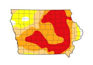
Iowa Drought Monitor map issued on 12/28/23 (Image courtesy of NOAA/NCEI)
There are only three areas of the state that aren’t in some level of drought or exceptionally dry conditions. One area is in the eastern edges of Jackson, Clinton and Scott Counties that abut the Mississippi River. The others are in northwest Iowa in the parts of Plymouth and Woodbury Counties that border the Missouri River as well as where the four corners of Cherokee, O’Brien, Clay and Buena Vista Counties meet.
Today: Increasing clouds, with a high near 36. North northwest wind 7 to 14 mph, with gusts as high as 22 mph.
Tonight: Cloudy, with a low around 26. North northwest wind 11 to 14 mph, with gusts as high as 23 mph.
Friday: Mostly sunny, with a high near 38. North northwest wind 8 to 11 mph, with gusts as high as 20 mph.
Saturday: Mostly sunny, with a high near 37.
Sunday: Partly sunny, with a high near 29. Blustery.
New Year’s Day: Sunny, with a high near 29.
Wednesday’s High in Atlantic was 37. Our Low this morning, was 28. Last year on this date, the High in Atlantic was 44 and the Low was 30. The Record High on Dec. 28th was 65 in 1984, and the Record Low was -25 in 1924. Sunrise is 7:45. Sunset is 4:57.
Today: A 30 percent chance of snow, mainly between 3pm and 4pm. Cloudy, with a high near 34. North wind 11 to 15 mph, with gusts as high as 24 mph. Little or no snow accumulation expected.
Tonight: Mostly cloudy, with a low around 24. North wind 6 to 10 mph, with gusts as high as 18 mph.
Thursday: A slight chance of snow between noon and 4pm. Mostly cloudy, with a high near 35. North northwest wind 7 to 15 mph, with gusts as high as 21 mph. Chance of precipitation is 20%.
Thursday Night: Mostly cloudy, with a low around 23. North northwest wind 10 to 14 mph, with gusts as high as 21 mph.
Friday: Mostly sunny, with a high near 37.
Friday Night: Mostly clear, with a low around 20.
Saturday: Sunny, with a high near 37.
Tuesday’s High in Atlantic was 33. Our Low was 28. We received .4″ of snow Tuesday into early this morning. The snow had a liquid value of .04″. Last year on this date, the High in Atlantic was 35 and the Low was 17. The Record High on Dec. 27th was 65 in 1946, and the Record Low was -21 in 1924. Sunrise is 7:45. Sunset is 4:56.


