
Today: Partly Cloudy. High 57. NW @ 10-15mph
Tonight: Fair to P/Cldy. Low 30. Light & variable winds.
Tomorrow: P/Cldy. High around 59. SE @ 5-10. Friday: P/Cldy. High near 62.
Saturday: Cldy w/rain. High 58.
Tuesday’s High in Atlantic was 68. The 24-hour Low ending at 7-a.m. today was 30. Last year on this date, our High in Atlantic was 62, and the low was 21. The All-time Record High in Atlantic on this date was 76 in 1986. The Record Low was -10 in 1912.
Early This Morning: Partly cloudy. Colder. Northwest wind 5 to 10 mph.
Today: Mostly sunny. Cooler. High in the upper 50s. Northwest wind 5 to 10 mph.
Tonight: Partly cloudy. Low around 40. Northeast wind 5 to 10 mph.
Thursday: Sunny. High in the lower 60s. Northeast wind 5 to 10 mph.
Thursday Night: Mostly clear. Low in the upper 30s. East wind 5 to 10 mph.
Friday: Sunny. High in the mid 60s. Southeast wind 5 to 15 mph.
Friday Night: Mostly cloudy. A 20 percent chance of showers after midnight. Low in the lower 40s.
Saturday: Showers likely. High in the lower 60s. Chance of showers 60 percent.
331 AM CST TUE MAR 8 2016
EARLY THIS MORNING…CLOUDY WITH A SLIGHT CHANCE OF LIGHT SHOWERS AND ISOLATED THUNDERSTORMS. SOUTH WIND AROUND 15 MPH WITH GUSTS TO AROUND 25 MPH. CHANCE OF PRECIPITATION 20 PERCENT.
TODAY…PARTLY SUNNY. A 20 PERCENT CHANCE OF LIGHT SHOWERS LATE IN THE AFTERNOON. BREEZY. HIGH IN THE UPPER 60S. SOUTHWEST WIND 10 TO 20 MPH WITH GUSTS TO AROUND 30 MPH.
TONIGHT…MOSTLY CLOUDY. A 20 PERCENT CHANCE OF LIGHT SHOWERS UNTIL EARLY MORNING. COLDER. LOW IN THE LOWER 40S. NORTH WIND 5 TO 10 MPH.
WEDNESDAY…PARTLY SUNNY. COOLER. HIGH IN THE MID 50S. NORTH WIND 5 TO 10 MPH.
WEDNESDAY NIGHT…MOSTLY CLOUDY. A CHANCE OF LIGHT SHOWERS THROUGH MIDNIGHT…THEN A SLIGHT CHANCE OF LIGHT SHOWERS AFTER MIDNIGHT. LOW AROUND 40. NORTH WIND AROUND 10 MPH. CHANCE OF SHOWERS 40 PERCENT.
THURSDAY…PARTLY SUNNY. HIGH IN THE UPPER 50S. NORTH WIND AROUND 10 MPH.
FRIDAY…PARTLY SUNNY. HIGH IN THE UPPER 50S.
The Shelby County Emergency Management Agency says participating businesses, and fire station in the County, should keep their “FIRE DANGER” signs in the HIGH category for the next few days, as record temperatures and breezy conditions will create near RED FLAG (extreme fire danger) conditions, especially between 11-a.m. and 6-p.m. each day.
Any open burning that can be moved to the early morning or late evening hours, will reduce the potential for fires to rapidly spread. The next update will be Thursday morning. 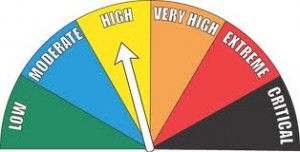
Today: Partly Cloudy to Cloudy. High 72. S @ 15-30.
Tonight: P/Cldy to Cldy w/scattered showers & thunderstorms. Low 58. S @ 10-15.
Tomorrow: P/Cldy to Cldy w/scatt. shwrs & tstrms. High 65. S @ 15-25.
Tom. Night: Mo. Cldy. Low 41.
Wednesday: Mo. Cldy. High 53.
Thursday: Mo. Cldy. High 55.
Sunday’s High in Atlantic was 72. The 24-hour Low ending at 7-a.m. today was 43. Last year on this date, our High in Atlantic was 57, and the low was 26. The All-time Record High in Atlantic on this date was 78 in 2000. The Record Low was -11 in 1982.
AREA COUNTIES: SAC-CRAWFORD-CARROLL-AUDUBON-GUTHRIE-DALLAS-CASS-ADAIR-MADISON-ADAMS-UNION-TAYLOR-RINGGOLD:
DAY ONE…TODAY AND TONIGHT: ISOLATED MAINLY NON SEVERE THUNDERSTORMS ARE POSSIBLE TONIGHT. THERE IS A POTENTIAL FOR UP TO PENNY SIZED HAIL WITH A FEW OF THE STRONGER STORMS OVERNIGHT.
DAYS TWO THROUGH SEVEN…TUESDAY THROUGH SUNDAY: ISOLATED NON SEVERE THUNDERSTORMS ARE POSSIBLE TUESDAY AND TUESDAY EVENING.
SPOTTER INFORMATION STATEMENT: SPOTTER ACTIVATION WILL NOT BE NEEDED.
Iowans who enjoy following the state’s ever-changing weather conditions are wanted to help with a national network of weather observers. State Climatologist Harry Hillaker says volunteers are needed for the Community Collaborative Rain, Hail and Snow network, otherwise known as CoCoRaHS. “Basically, it’s an internet-based reporting system where people with a particular type of rain gage can report each day on precipitation amounts, snowfall totals, snow depths, hail events, and all sorts of things that can be reported through the network,” Hillaker says.
The data that’s collected by the volunteer observers is available for free online and helps the National Weather Service with flood forecasting, drought assessments, and more. “We currently have about 200 active observers across the state right now,” Hillaker says. “Almost 70 of Iowa’s 99 counties have observers and we could definitely use way more than that.”
The CoCoRaHS network was established in Colorado in 1998 and has spread to all 50 states. Iowa joined the volunteer network in 2007. Hillaker says weather observers are needed statewide, but the most critical needs are in Osceola, Palo Alto, Pocahontas, Worth, Wright, Allamakee, Calhoun, Carroll, Shelby, Audubon, Cedar, Adams, Monroe, Louisa, Davis and Van Buren Counties.
More information about the network is available on the CoCoRaHS web site at www.cocorahs.org. The website includes information on how to join, where to purchase your rain gage and how to accurately measure and report rain and snow.
(Radio Iowa)
355 AM CST MON MAR 7 2016
EARLY THIS MORNING…MOSTLY CLOUDY. WARMER. SOUTH WIND 5 TO 10 MPH.
TODAY…MOSTLY CLOUDY. BREEZY. HIGH IN THE LOWER 70S. SOUTH WIND 10 TO 15 MPH INCREASING TO 20 TO 25 MPH IN THE AFTERNOON.
TONIGHT…MOSTLY CLOUDY. A SLIGHT CHANCE OF SHOWERS AND ISOLATED THUNDERSTORMS OVERNIGHT. BREEZY. LOW IN THE UPPER 50S. SOUTH WIND 15 TO 25 MPH. CHANCE OF PRECIPITATION 20 PERCENT.
TUESDAY…MOSTLY CLOUDY. A SLIGHT CHANCE OF SHOWERS IN THE MORNING…THEN A SLIGHT CHANCE OF SHOWERS AND ISOLATED THUNDERSTORMS IN THE AFTERNOON. BREEZY. HIGH IN THE UPPER 60S. SOUTHWEST WIND 15 TO 20 MPH WITH GUSTS TO AROUND 30 MPH. CHANCE OF PRECIPITATION 20 PERCENT.
TUESDAY NIGHT…MOSTLY CLOUDY. A SLIGHT CHANCE OF SHOWERS AND ISOLATED THUNDERSTORMS THROUGH MIDNIGHT…THEN A SLIGHT CHANCE OF SHOWERS AFTER MIDNIGHT. COLDER. LOW IN THE LOWER 40S. NORTH WIND 10 TO 15 MPH. CHANCE OF PRECIPITATION 20 PERCENT.
WEDNESDAY…PARTLY SUNNY. COOLER. HIGH IN THE MID 50S. NORTH WIND 10 TO 15 MPH.
EARLY THIS MORNING…MOSTLY CLOUDY. SOUTH WIND 10 TO 15 MPH.
TODAY…PARTLY SUNNY. WINDY…WARMER. HIGH IN THE UPPER 60S. SOUTH WIND 15 TO 30 MPH WITH GUSTS TO AROUND 40 MPH.
TONIGHT…MOSTLY CLOUDY. A 20 PERCENT CHANCE OF LIGHT SHOWERS AFTER MIDNIGHT. BREEZY…WARMER. LOW IN THE MID 50S. SOUTH WIND 15 TO 20 MPH WITH GUSTS TO AROUND 30 MPH.
MONDAY…MOSTLY CLOUDY WITH A 20 PERCENT CHANCE OF LIGHT SHOWERS. BREEZY. HIGH IN THE LOWER 70S. SOUTH WIND 15 TO 25 MPH WITH GUSTS TO AROUND 35 MPH.
MONDAY NIGHT…MOSTLY CLOUDY WITH A SLIGHT CHANCE OF SHOWERS AND ISOLATED THUNDERSTORMS. BREEZY. LOW IN THE MID 50S. SOUTH WIND 15 TO 25 MPH. CHANCE OF PRECIPITATION 20 PERCENT.
TUESDAY…PARTLY SUNNY WITH A SLIGHT CHANCE OF SHOWERS AND ISOLATED THUNDERSTORMS. BREEZY. HIGH IN THE MID 60S. SOUTHWEST WIND 15 TO 20 MPH WITH GUSTS TO AROUND 30 MPH. CHANCE OF PRECIPITATION 20 PERCENT.
WEDNESDAY…PARTLY SUNNY. HIGH IN THE MID 50S.
Skyscan Forecast Saturday, March 5, 2016 Chris Parks


