
FOR SAC-CRAWFORD-CARROLL-GREENE-AUDUBON-GUTHRIE-DALLAS-ADAIR-MADISON and UNION COUNTIES in the KJAN listening area…A WIND ADVISORY REMAINS IN EFFECT FROM 7 AM TO 7 PM TODAY.
SUSTAINED WINDS OF 25 TO 35 MPH WINDS WITH GUSTS OVER 50 MPH ARE POSSIBLE. SIGNIFICANT CROSS WINDS WILL OCCUR OVER NORTH TO SOUTH RUNNING ROADS. THESE WINDS WILL CAUSE TRAVEL DIFFICULTIES FOR HIGH PROFILE VEHICLES. ANY UNSECURED SMALL OBJECTS MAY BE BLOWN AROUND BY THE WIND.
PRECAUTIONARY/PREPAREDNESS ACTIONS… A WIND ADVISORY MEANS THAT WINDS OF 35 MPH ARE EXPECTED. WINDS THIS STRONG CAN MAKE DRIVING DIFFICULT…ESPECIALLY FOR HIGH PROFILE VEHICLES. USE EXTRA CAUTION.
Today: Sunny…windy. High in the mid 50s. West wind 15 to 20 mph with gusts to around 35 mph increasing to 20 to 30 mph with gusts to around 45 mph in the afternoon.
Tonight: Mostly cloudy in the evening then becoming partly cloudy. Low in the mid 30s. West wind 10 to 15 mph. Gusts up to 30 mph through midnight.
Thursday: Mostly sunny. Breezy. High in the lower 50s. West wind 10 to 20 mph increasing to 20 to 25 mph in the afternoon.
Thursday Night: Mostly cloudy. Low around 30. Northwest wind 5 to 15 mph. Gusts up to 25 mph through midnight.
Friday: Mostly cloudy. High in the mid 40s.
Friday Night: Mostly cloudy with a 20 percent chance of light rain and light snow. Low around 30.
Saturday: Partly sunny. A slight chance of light rain and light snow in the morning…then a slight chance of light rain in the afternoon. High in the mid 40s. Chance of precipitation 20 percent.
MONONA-HARRISON-SHELBY-POTTAWATTAMIE-MILLS-MONTGOMERY-FREMONT and PAGE COUNTIES IN IA…741 PM CDT TUE MAR 15 2016
THE NATIONAL WEATHER SERVICE IN OMAHA SAYS THE GRASSLAND FIRE DANGER INDEX IS EXPECTED TO REACH THE VERY HIGH CATEGORY OVER MOST OF EASTERN NEBRASKA AND SOUTHWEST IOWA WEDNESDAY AFTERNOON.
RELATIVE HUMIDITIES WILL DROP INTO THE 25 TO 35 PERCENT RANGE, WITH NORTHWEST WINDS FROM 15 TO 30 MPH. GUSTS MAY REACH AROUND 40 MPH.
A VERY HIGH FIRE IS EXPECTED AGAIN THURSDAY AFTERNOON FOR AT LEAST PARTS OF THE AREA. OUTDOOR BURNING IS NOT RECOMMENDED THE NEXT COUPLE OF DAYS.
NATIONAL WEATHER SERVICE DES MOINES IA
305 PM CDT TUE MAR 15 2016

...VERY STRONG WINDS EXPECTED LATE TONIGHT INTO WEDNESDAY...

.LOW PRESSURE WILL QUICKLY STRENGTHEN TONIGHT AS IT LIFTS
NORTHEAST THROUGH EASTERN IOWA AND INTO WISCONSIN. VERY STRONG
WEST TO NORTHWEST WINDS ARE EXPECTED TO DEVELOP ON THE BACK SIDE
OF THIS SYSTEM BEGINNING TONIGHT. A SECOND SURGE OF STRONGER WINDS
WILL RE-DEVELOP FROM MID-MORNING WEDNESDAY THROUGH WEDNESDAY
EVENING. THIS SYSTEM HAS THE POTENTIAL TO PRODUCE SUSTAINED WINDS
FROM 25 TO 40 MPH WITH GUSTS IN EXCESS OF 60 MPH. THE STRONGEST
WINDS ARE EXPECTED ALONG AND NORTH OF U.S. HIGHWAY 30.

SAC-CRAWFORD-CARROLL-AUDUBON-GUTHRIE-ADAIR-MADISON-UNION-

...WIND ADVISORY IN EFFECT FROM 7 AM TO 7 PM CDT WEDNESDAY...

THE NATIONAL WEATHER SERVICE IN DES MOINES HAS ISSUED A WIND
ADVISORY...WHICH IS IN EFFECT FROM 7 AM TO 7 PM CDT WEDNESDAY.

* TIMING...WEDNESDAY MORNING THROUGH WEDNESDAY EVENING.

* WINDS...SUSTAINED 25 TO 35 MPH WINDS WITH GUSTS OVER 50 MPH
  POSSIBLE.

* IMPACTS...SIGNIFICANT CROSS WINDS WILL OCCUR OVER NORTH TO SOUTH
  RUNNING ROADS. WINDS IN EXCESS OF 50 MPH MAY CAUSE HIGH PROFILE
  VEHICLES AND SEMI TRUCKS TO LOOSE CONTROL. TREE DAMAGE AND
  SUBSEQUENT POWER LINE DAMAGE IS ALSO POSSIBLE. SECURE LOOSE
  OBJECTS.

PRECAUTIONARY/PREPAREDNESS ACTIONS...

A WIND ADVISORY MEANS THAT WINDS OF 35 MPH ARE EXPECTED. WINDS
THIS STRONG CAN MAKE DRIVING DIFFICULT...ESPECIALLY FOR HIGH
PROFILE VEHICLES. USE EXTRA CAUTION.
Forecasters say scattered showers and thunderstorms are in today’s (Tuesday) forecast for much of Iowa with the chance of severe weather this afternoon. That includes the possibility of hail, high winds and tornadoes. A High Wind Watch is posted for late today into tomorrow, according to Frank Boksa, a meteorologist at the National Weather Service office in metro Des Moines.
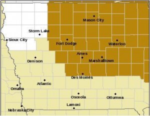
High Wind Watch for counties shaded in brownish-gold
Boksa says, “We’re going to see winds out of the north and they’re going to increase to 30 or 40 miles an hour sustained and we could see gusts of 60 miles an hour or higher.” While the calendar says spring is due to arrive this weekend, Iowa may be returning to winter weather later this week.
“Since we’re bringing in colder air, especially at night, temperatures will likely drop to cold enough to change that rain over to snow or at least a wintery mix of rain and snow,” Boksa says. “That’s what we’re expecting Thursday into Friday.”
(Radio Iowa)
Today: Patchy dense fog possible thru 8-a.m. over parts of western/southwest IA; Isolated showers and thunderstorms, otherwise Mostly cloudy. High near 60. NW @ 10-20 w/gusts to near 30. Chance of precipitation is 20%.
Tonight: Isolated showers ending late. Gradually becoming mostly clear. Low 34. NW @ 15-25.
Wednesday: P/Cldy to Cldy & windy. High near 53. NW @ 15-30 w/gusts to near 40.
Wed. Night: Partly cloudy & breezy. Low around 34. W @ 15-30.
Thursday: P/Cldy to Cldy & windy. High around 47.
Friday: P/Cldy to Cldy. High near 44.
Monday’s High in Atlantic was 74. The 24-hour Low ending at 7-a.m. today was 45. We received .32” rain overnight into early this morning. Last year on this date, our High in Atlantic was 73, and the low was 34. The All-time Record High in Atlantic on this date was 79 in 2003. The Record Low was 0 in 1944.
HARRISON-SHELBY-POTTAWATTAMIE-MILLS-MONTGOMERY-FREMONT-PAGE COUNTIES…
653 AM CDT TUE MAR 15 2016
…PATCHY DENSE FOG EARLY THIS MORNING…
BE PREPARED FOR PATCHY DENSE FOG EARLY THIS MORNING ACROSS PORTIONS OF EXTREME EASTERN NEBRASKA AND WESTERN IOWA. VISIBILITIES COULD RANGE 1/4 TO 1/2 MILE IN SOME AREAS. A COLD FRONT MOVING IN FROM THE WEST WILL RAPIDLY IMPROVE VISIBILITIES THROUGH 8 AM.
356 AM CDT TUE MAR 15 2016
EARLY THIS MORNING…WIDESPREAD LIGHT SHOWERS AND SCATTERED THUNDERSTORMS. NORTHWEST WIND 5 TO 10 MPH WITH GUSTS TO AROUND 25 MPH. CHANCE OF PRECIPITATION NEAR 100 PERCENT.
TODAY…MOSTLY CLOUDY WITH ISOLATED THUNDERSTORMS. BREEZY…COOLER. HIGH IN THE LOWER 60S. NORTH WIND 5 TO 10 MPH INCREASING TO NORTHWEST 15 TO 25 MPH IN THE AFTERNOON. CHANCE OF THUNDERSTORMS 20 PERCENT.
TONIGHT…MOSTLY CLOUDY WITH A SLIGHT CHANCE OF RAIN SHOWERS AND ISOLATED THUNDERSTORMS IN THE EVENING…THEN MOSTLY CLOUDY WITH A SLIGHT CHANCE OF LIGHT RAIN SHOWERS BEFORE MIDNIGHT. PARTLY CLOUDY AFTER MIDNIGHT. BREEZY…COLDER. LOW IN THE MID 30S. WEST WIND 15 TO 20 MPH WITH GUSTS TO AROUND 30 MPH. CHANCE OF PRECIPITATION 20 PERCENT.
WEDNESDAY…SUNNY…BREEZY. HIGH IN THE MID 50S. WEST WIND 15 TO 25 MPH WITH GUSTS TO AROUND 40 MPH.
THURSDAY…MOSTLY SUNNY. BREEZY. HIGH IN THE UPPER 40S. WEST WIND 10 TO 20 MPH SHIFTING TO THE NORTHWEST 20 TO 25 MPH IN THE AFTERNOON. GUSTS UP TO 40 MPH.
FRIDAY…MOSTLY CLOUDY WITH A 20 PERCENT CHANCE OF LIGHT RAIN. HIGH IN THE MID 40S.
Officials with the Shelby County Emergency Management Agency say the light rains in the forecast today will not be enough to stop the potential for fire to spread rapidly. The Fire Danger category will remain “HIGH” until at least Thursday morning, when the next update is expected.
After today and tomorrow, winds and very low relative humidity will combine with the sunshine to rapidly dry the dead vegetation, again, making for dangerous fire conditions.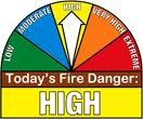
The National Weather Service is forecasting very dry and very high fire condition for later this week.
The Shelby County EMA says you should remember to call your controlled burns in to the EMA Communications center at (712)- 755—2124, and, contact your local Fire Chief.
The National Weather Service in Omaha has issued a DENSE FOG ADVISORY until 10-a.m. for Monona-Harrison-Shelby-Pottawattamie-Mills-Montgomery-Fremont and Page Counties in west/southwest Iowa. Visibilities will be reduced to near zero at times through about 9 or 10 a.m.
A DENSE FOG ADVISORY remains in effect until 10-a.m. as well, for Cass-Adair-Adams-Audubon-Guthrie-Dallas-Madison-Crawford-Carroll-Union and Taylor Counties in the KJAN listening area.
If driving, slow down, use your headlights, and leave plenty of distance between your vehicle and those in front of you.


