
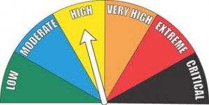
The field/grassland Fire Danger Index remains HIGH in Shelby County. Emergency Management Coordinator Bob Seivert says the next few days are expected to be windy. Drying, along with abundant sunshine, at least through Wednesday, will likely continue to contribute to the danger of controlled burns spreading beyond their intended area. There’s a 50% chance of rain Tuesday night through Wednesday morning, which Seivert says will allow the area to green-up a bit, thereby reducing the fire danger threat.
 Officials are still asking you to conduct any Controlled Burns during the early morning or late evening hours, when winds will be reduced or near calm.
Today: Partly Cloudy. High 62. S @ 10-15..
Tonight: P/Cldy. Low 41. S @ 5-10.
Tomorrow: P/Cldy to Cldy. High 68. S @ 15-30.
Tom. Night: Mo. Cldy & breezy w/a chance of showers. Low 51.
Wednesday: Mo. Cldy w/afternoon shwrs & tstrms. High 70.
Thursday: Mo. Cldy w/rain in the morning. High around 47.
Sunday’s High in Atlantic was 49. The Low thru 7-a.m. today was 21. Last year on this date, our High in Atlantic was 50, and the low was 32. The All-time Record High in Atlantic on this date was 84 in 1910 & 1986. The Record Low was 11 in 1898.
345 AM CDT MON MAR 28 2016
EARLY THIS MORNING…CLEAR. PATCHY FOG. EAST WIND NEAR 5 MPH.
TODAY…SUNNY…WARMER. PATCHY FOG THROUGH MID MORNING. HIGH IN THE LOWER 60S. SOUTH WIND 5 TO 15 MPH.
TONIGHT…MOSTLY CLEAR. NOT AS COOL. LOW AROUND 40. SOUTHEAST WIND AROUND 10 MPH.
TUESDAY…PARTLY SUNNY. A 20 PERCENT CHANCE OF LIGHT SHOWERS LATE IN THE AFTERNOON. BREEZY. HIGH IN THE MID 60S. SOUTHEAST WIND 10 TO 15 MPH INCREASING TO SOUTH 20 TO 25 MPH IN THE AFTERNOON.
TUESDAY NIGHT…MOSTLY CLOUDY WITH A 20 PERCENT CHANCE OF LIGHT SHOWERS. BREEZY…WARMER. LOW IN THE LOWER 50S. SOUTH WIND 15 TO 20 MPH WITH GUSTS TO AROUND 30 MPH.
WEDNESDAY…CLOUDY WITH A 50 PERCENT CHANCE OF THUNDERSTORMS. BREEZY. HIGH IN THE UPPER 60S. SOUTH WIND 15 TO 20 MPH.
WEDNESDAY NIGHT…MOSTLY CLOUDY. A CHANCE OF THUNDERSTORMS THROUGH MIDNIGHT…THEN A CHANCE OF SHOWERS AFTER MIDNIGHT. COLDER. LOW IN THE LOWER 40S. CHANCE OF PRECIPITATION 50 PERCENT.
THURSDAY…MOSTLY CLOUDY WITH A 20 PERCENT CHANCE OF RAIN. BREEZY…COOLER. HIGH IN THE LOWER 50S.
Today: Cloudy through mid-morning, then gradual clearing, with a high near 50. Northwest wind 10 to 15 mph, with gusts to near 20.
Tonight: Patchy fog after 4am. Otherwise, clear, with a low around 29.
Monday: Patchy fog before 10am. Otherwise, sunny, with a high near 64. South wind 5 to 15 mph, with gusts as high as 20 mph.
Monday Night: Partly cloudy, with a low around 42.
Tuesday: Partly Sunny & windy, w/a 20% chance of afternoon showers. High near 65. S/SE winds 10-20 w/gusts to near 35mph.
Tuesday Night: Mostly Cloudy & windy w/a slight chance of showers and thunderstorms. Low around 53.
Wednesday: Mostly Cloudy & breezy, w/a 50% chance of showers and thunderstorms. High near 70.
Saturday’s High in Atlantic was 44. The Low thru 6-a.m. today was 33. We received .35” of precipitation here, Saturday. Last year on this date, our High in Atlantic was 39, and the low was 19. The All-time Record High in Atlantic on this date was 85 in 1895. The Record Low was 6 in 1894.
346 AM CDT SAT MAR 26 2016
EARLY THIS MORNING…CLOUDY. NOT AS COOL. SOUTH WIND 5 TO 10 MPH.
TODAY…A CHANCE OF RAIN THROUGH MID MORNING…THEN RAIN LIKELY BEFORE NOON. SHOWERS IN THE AFTERNOON. HIGH IN THE UPPER 40S. SOUTH WIND 5 TO 10 MPH. CHANCE OF PRECIPITATION 90 PERCENT.
TONIGHT…CLOUDY. A CHANCE OF RAIN SHOWERS IN THE EVENING…THEN A SLIGHT CHANCE OF LIGHT RAIN BEFORE MIDNIGHT. LOW IN THE LOWER 30S. NORTHWEST WIND 10 TO 15 MPH. CHANCE OF PRECIPITATION 50 PERCENT.
SUNDAY…PARTLY SUNNY UNTIL LATE AFTERNOON THEN CLEARING. HIGH IN THE LOWER 50S. NORTHWEST WIND 10 TO 15 MPH.
SUNDAY NIGHT…CLEAR. LOW IN THE LOWER 30S. WEST WIND 5 TO 10 MPH SHIFTING TO THE SOUTH AFTER MIDNIGHT.
MONDAY…SUNNY…WARMER. HIGH IN THE MID 60S. SOUTH WIND 5 TO 15 MPH.
TUESDAY…MOSTLY CLOUDY WITH A 30 PERCENT CHANCE OF SHOWERS. HIGH IN THE MID 60S.
Today: Area of fog this morning; P/Cldy. High 54. S @ 10-15.
Tonight: Cldy w/light rain developing late. Low 39. S @ 5-10.
Tomorrow: Mo. Cldy w/light rain. High 46. S-N @ 10-15.
Tom. Night: Mo. Cldy w/light rain ending by around 7-pm. Low 29.
Sunday: P/Cldy. High near 50.
Monday: P/Cldy. High around 62.
Thursday’s High in Atlantic was 44. We received a Trace of snowfall Thursday morning, between about 8-and 10-a.m. The 24-hour Low ending at 7-a.m. today was 18. Last year on this date, our High in Atlantic was 45, and the low was 25. The All-time Record High in Atlantic on this date was 91 in 1907. The Record Low was 5 in 1894.
Today: Mostly sunny until late afternoon then becoming mostly cloudy. A 20 percent chance of light rain late in the afternoon. Warmer. High in the mid 50s. South wind 5 to 10 mph increasing to around 15 mph in the afternoon. Gusts up to 25 mph.
Tonight: Mostly cloudy. A slight chance of light rain through midnight…then a chance of light rain after midnight. Not as cool. Low in the upper 30s. South wind 5 to 15 mph. Chance of rain 30 percent.
Saturday: Cloudy. A chance of light rain in the morning…then a slight chance of light rain in the afternoon. High around 50. Southwest wind 5 to 10 mph shifting to the northwest 10 to 15 mph with gusts to around 25 mph in the afternoon. Chance of rain 50 percent.
Saturday Night: Mostly cloudy. Low in the upper 20s. Northwest wind 5 to 15 mph.
Sunday: Partly sunny. High around 50.
Monday: Sunny…warmer. High in the lower 60s.
Officials with the Shelby County Emergency Management Agency, today (Thursday), said the Fire Danger index in the County will remain HIGH for the next few days, at least. Emergency Management Coordinator Bob Seivert says even with the recent rain, drying will occur rapidly with any sunshine. Winds will continue to dry out the vegetation.
Seivert warns that any field or grassland fires that get out of control, may be difficult for heavy fire apparatus to reach, due to the soft soil. Fire departments and business with Fire Danger signs in their windows, are asked to keep those indicators set to “HIGH” this weekend.
Authorities therefore are asking anyone who plans to conduct controlled burns to contact their local fire chief, first. Be sure and call 755-2124 also, with the location of your burn, so dispatchers can gather logistical data. The next “Fire Danger” update will be on Monday, March 28th.
Today: Cloudy w/a 50% chance of snow, mainly before 10am; Becoming P/Cldy this afternoon. High 39. NW @ 20-40mph. New snow accumulation of less than 1”.
Tonight: Mostly clear, with a low around 20. N/NW @ 10-15 becoming light & variable.
Friday: Increasing clouds, with a high near 54. S @ 10-15 w/gusts to 25.
Fri. Night: Mostly cloudy w/a slight chance of rain after midnight. Low around 37.
Saturday: A slight chance of rain and/or snow. High 46
Sat.Night: A 20% chance of rain before 8pm, otherwise mostly cloudy. Low around 28.
Sunday: P/Cldy to Cldy. High near 44.
Wednesday’s High in Atlantic was 50. The 24-hour Low ending at 7-a.m. today was 29. We received .46” rain yesterday, in Atlantic, at the KJAN studios. Last year on this date, our High in Atlantic was 34, and the low was 32. The All-time Record High in Atlantic on this date was 83 in 1967. The Record Low was -2 in 1974.
Early This Morning: Cloudy with a 50 percent chance of light rain…light freezing rain and light snow. Windy…colder. Northeast wind 20 to 30 mph with gusts to around 40 mph.
Today: Cloudy with a chance of light snow through mid morning… Then cloudy with a slight chance of light snow before noon. Partly sunny in the afternoon. Windy…colder. High in the upper 30s. North wind 25 to 30 mph decreasing to 15 to 25 mph in the afternoon. Gusts up to 40 mph. Chance of snow 50 percent.
Tonight: Mostly clear. Low in the mid 20s. Northwest wind 5 to 10 mph with gusts to around 25 mph shifting to the southwest after midnight.
Friday: Mostly sunny. Breezy…warmer. High in the mid 50s. South wind 5 to 15 mph increasing to 15 to 20 mph in the afternoon.
Friday Night: Mostly cloudy. A 20 percent chance of light rain after midnight. Not as cool. Low in the upper 30s. South wind 5 to 15 mph.
Saturday: Mostly cloudy. A chance of light rain and a slight chance of light snow in the morning…then a slight chance of light rain in the afternoon. High in the upper 40s. West wind near 10 mph increasing to north with gusts to around 25 mph in the afternoon. Chance of precipitation 40 percent.
Sunday: Partly sunny. High in the upper 40s.


