
(Radio Iowa) – Snow is NOT in Iowa’s forecast — until late Wednesday and Thursday. Meteorologist Allan Curtis at the National Weather Service office in the Des Moines metro says it will be nothing like what Iowa has endured over the past few days. “Certainly not 10 inches of snow like we saw the last couple of storm,” Curtis says. The National Weather Service reports 25-and-a-half (25.5) inches of snow fell in the Quad Cities from Monday through Friday of last week. Dubuque recorded 24-point-seven inches of snow during the same period. Nearly two feet fell in Waterloo from Monday through Friday. Those are all record amounts for a five day period. Curtis says the snow that has piled up will stay a while.
“Even if we got warm — 30 or 40 degrees — we would need at least a couple of weeks of that to make a real dent in the people’s general snow pack in their yards,” Curis says. “There are areas — edges of driveways, parking lots, rural areas — that have feet of snow and it’s going to take even longer for that, so for better or worse, I hope people are prepared to see this snow stick around for a number of weeks.” Today’s (Monday’s) high will below zero. By six o’clock, when tens of thousands of Iowans will be arriving at Caucus sites around the state, wind chills will flirt with 30 below zero.
“Really, the take away there is when traveling, please be careful because if you get stuck, that’s when the wind chill and the cold really become a concern for people,” Curtis says. “Just dress appropriately. Take your time.” There is a wind chill warning in effect for Iowa until noon on Tuesday.
Today (Monday) M.L.King Day: Mostly cloudy and cold, with a high near -3. W/NW winds 10-25 mph. Wind chill values as low as -35. **WIND CHILL WARNING continues until Noon Tuesday***
Tonight: Mostly clear, with a low around -15. W/NW winds 10-15. Wind chill values as low as -35.
Tomorrow: Sunny and cold, with a high near 4. W @ 10-20 mph. Wind chill values as low as -35.
Wednesday: Partly sunny, with a high near 18.
Thursday: A 30 percent chance of snow after noon. Partly sunny and cold, with a high near 9.
Sunday’s High in Atlantic was -9. The was -20. Last year on this date, the High in Atlantic was 48 and the Low was 33. The Record High for Jan. 15th in Atlantic, was 61 in 1990. The Record Low was -23, in 1905. Sunrise today: 7:44. Sunset: 5:15.
**WIND CHILL WARNING UNTIL NOON, TUESDAY**
Today: Mostly sunny and cold, with a steady temperature around -17. W/NW winds 10-25 mph. Wind chill values as low as -45.
Tonight: Mostly cloudy, with a low around -19. W/NW @ 10. Wind chill values as low as -35.
M.L.King Day: Mostly cloudy and cold, with a high near -5. W/NW @ 10-25 mph. Wind chill values as low as -30.
Monday Night: Partly cloudy, with a low around -15. W/NW @ 10-20 mph.
Tuesday: Sunny and cold, with a high near 5.
Tuesday Night: Mostly clear, with a low around -7.
Wednesday: Partly sunny, with a high near 17.
Saturday’s High in Atlantic was -1. Our Low this morning was -19. We received a trace of snowfall yesterday. Last year on this date, the High in Atlantic was 41 and the Low was 4. The Record High for Jan. 14th in Atlantic, was 54 in 1914. The Record Low was -29, in 1957. Sunrise today: 7:44. Sunset: 5:13.
Early this morning: Patchy blowing snow. Mostly cloudy, with a steady temperature around -1. Wind chill values as low as -25. Blustery, with a northwest wind around 18 mph, with gusts as high as 26 mph. BLIZZARD WARNING REMAINS IN EFFECT UNTIL 6 AM.
Today: A 40 percent chance of snow, mainly before 1pm. Patchy blowing snow. Mostly cloudy and cold, with a temperature falling to around -9 by 5pm. Wind chill values as low as -35. Windy, with a northwest wind 20 to 26 mph, with gusts as high as 37 mph. New snow accumulation of less than a half inch possible. WINTER WEATHER ADVISORY REMAINS IN EFFECT FROM 6 AM TO 6 PM CST SATURDAY; WIND CHILL WARNING REMAINS IN EFFECT UNTIL NOON CST TUESDAY.
Tonight: Patchy blowing snow before 2am. Mostly cloudy, with a low around -19. Wind chill values as low as -40. Windy, with a west northwest wind 15 to 23 mph, with gusts as high as 32 mph.
Sunday: Mostly sunny and cold, with a high near -10. Wind chill values as low as -40. West northwest wind 11 to 14 mph, with gusts as high as 20 mph.
M.L.King Day: Mostly cloudy and cold, with a high near -4. Blustery.
Tuesday: Sunny and cold, with a high near 1. Breezy.
Friday’s High in Atlantic was 10. Our Low this morning (24-hour Low ending at 7-a.m.), was -3. Snowfall from 7-a.m. Friday through 7-a.m. today amounted to 3.5-inches, for a total of 7.8 inches. Last year on this date, the High in Atlantic was 31 and the Low was 16. The Record High for Jan. 13th in Atlantic, was 62 in 1987. The Record Low was -24, in 1916. Sunrise today: 7:45. Sunset: 5:12.
Today: **Winter Storm Warning until 10-a.m., then a Blizzard Warning until 6-a.m. Saturday** Snow, mainly before 3pm. Widespread blowing snow, mainly between 3pm and 4pm. High around 10, with wind chill values as low as -15. N/NW winds 20-35 mph. New snow accumulation of 2 to 4 inches possible.
Tonight: Patchy blowing snow. Mostly cloudy, with a low around -5. NW @ 20-40 mph. Wind chill values as low as -25.
Saturday: Areas of blowing snow. High around Zero. NW @ 25-40 mph. Wind chill values as low as -35.
Saturday Night: Patchy blowing snow before 2am. Mostly cloudy, with a low around -17. NW @ 15-30 mph.
Sunday: Mostly sunny and cold, with a high near -8. Blustery.
Sunday Night: Mostly cloudy, with a low around -20.
M.L.King Day: Partly sunny and cold, with a high near -5. Blustery.
Thursday’s High in Atlantic was 20. Our Low this morning (as of 7-a.m.) was 8. Snowfall as of 7-a.m. was 4-inches at KJAN. Last year on this date, the High was 27 and the Low was 16. The Record High for Jan. 12th in Atlantic, was 57 in 1961 & 1987. The Record Low was -37, in 1974. Sunrise today: 7:45. Sunset: 5:11.
(Radio Iowa) – This week will end much as it started, with a whopper snowstorm. Forecasters say a Winter Storm Warning is posted for 98 of Iowa’s 99 counties from tonight (Thursday) through tomorrow night, with near-blizzard conditions likely. National Weather Service meteorologist Kristi Carter says it’ll be another doozy. “Our snow amounts for much of central Iowa are going to range from around five to 10 inches,” Carter says, “and that is also going to be combined with on Friday afternoon into early Saturday, winds that are going to be gusting over 40 miles an hour.” While the snowstorm that ran Monday into Tuesday dropped up to 15 inches of heavy, wet snow on the state, she says this approaching storm will produce a lighter type of snowflake.
“That snow is going to be very fluffy and blowable,” Carter says, “and those gusty winds, we also already have snow on the ground from the storms we’ve had already this week, that’s going to lead to a significant blowing snow threat especially later Friday into Saturday.” That could mean white-out conditions and a very unsafe recipe for motorists, particularly if there’s icing on the roads. She notes this next storm will be much colder than the one earlier in the week.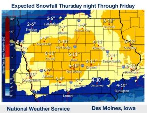 “Temperatures will be falling into single digits by early Saturday,” Carter says. “Our wind chills are going to be falling well below zero tomorrow night into Saturday, and then will continue to fall Saturday night into Sunday with wind chills of negative-20 to around negative-40.” The forecast calls for the -high- temperatures on Sunday to only be in the negative single digits, with lows approaching 20-below. Our furnaces will be working overtime as it doesn’t appear that there will be much of a change for days.
“We are looking at a small warm-up towards the middle of the week, around the Wednesday timeframe, where we’re looking at temperatures that start to reach the teens again,” Carter says, “so that’s at least better than the single digits but certainly looking pretty cold through the week.” Keep up with the changing forecast at weather-dot-gov and stay informed about road conditions by visiting 5-1-1-i-a-dot-org.
Today: A 20 percent chance of snow after 5pm. Mostly cloudy, with a high near 19. Wind chill values as low as 5. Northwest wind 7 to 11 mph becoming northeast in the afternoon.
Tonight: **WINTER STORM WARNING in effect from 6-p.m. through midnight Friday**Snow, mainly after 8pm. The snow could be heavy at times. Patchy blowing snow after 11pm. Low around 7. Wind chill values as low as -10. Windy, with a north northeast wind 11 to 21 mph, with gusts as high as 31 mph. Chance of precipitation is 90%. New snow accumulation of 3 to 7 inches possible.
Friday: Snow likely, mainly before noon. Areas of blowing snow. Cloudy, with a temperature falling to around 7 by 8am. Wind chill values as low as -15. Windy, with a north northwest wind 22 to 25 mph, with gusts as high as 34 mph. Chance of precipitation is 60%. New snow accumulation of 1 to 3 inches possible.
Friday Night: Patchy blowing snow. Mostly cloudy, with a low around -5. Windy, with a northwest wind 20 to 22 mph, with gusts as high as 31 mph.
Saturday: A 20 percent chance of snow after noon. Patchy blowing snow before 8am, then patchy blowing snow after 11am. Mostly cloudy and cold, with a high near 1. Windy.
Saturday Night: Patchy blowing snow. Mostly cloudy, with a low around -19. Windy.
Sunday: Mostly sunny and cold, with a high near -7. Blustery.
Wednesday’s High in Atlantic was 27. The Low was 12. Snowfall in Atlantic was four-tenths of an inch (.4″), which yielded .04″ liquid precipitation. Last year on this date, the High was 33 and the Low was 25. The Record High for Jan. 11th in Atlantic, was 55 in 1986. The Record Low was -22, in 1892. Sunrise today: 7:45. Sunset: 5:10.
Today: A 40 percent chance of snow, mainly after 2pm. Increasing clouds, with a high near 26. Wind chill values as low as zero. South wind 7 to 15 mph becoming west southwest in the afternoon. Winds could gust as high as 22 mph. New snow accumulation of less than a half inch possible.
Tonight: A 20 percent chance of snow before 8pm. Cloudy, then gradually becoming partly cloudy, with a low around 9. West northwest wind 6 to 11 mph.
Tomorrow: A 20 percent chance of snow after noon. Increasing clouds, with a high near 19. Wind chill values as low as zero. Northwest wind 6 to 11 mph becoming north northeast in the morning.
Tom. Night: Snow likely. Cloudy, with a low around 5. Blustery, with a north northeast wind 11 to 17 mph, with gusts as high as 26 mph. Chance of precipitation is 70%. New snow accumulation of 3 to 5 inches possible.
Friday: A 50 percent chance of snow. Mostly cloudy and cold, with a high near 10. Windy.
Friday Night: A 20 percent chance of snow before midnight. Mostly cloudy, with a low around -6. Windy.
Saturday: A 30 percent chance of snow, mainly after noon. Mostly cloudy and cold, with a high near 3. Windy.
Atlantic (KJAN), 4.6″
Massena, 5.0″
Glenwood: 5 inches
Malvern: 5.5 inches
Sioux City: 11 inches
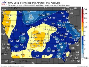 Winterset: 10.0 inches
Earlham: 9.3
Adel: 8.0
Panora: 6.5
Creston: 6.3
WINTER STORM WARNING CONTINUES UNTIL 6-P.M.
Early this morning: Snow. The snow could be heavy at times. Patchy blowing snow. Steady temperature around 30. Blustery, with a north wind 17 to 20 mph, with gusts as high as 29 mph. Chance of precipitation is 100%. Total nighttime snow accumulation of 3 to 5 inches possible.
Today: Snow, mainly before 11am. Patchy blowing snow before 5pm. Temperature falling to around 22 by 5pm. Wind chill values as low as 5. Windy, with a north wind 18 to 25 mph, with gusts as high as 38 mph. Chance of precipitation is 80%. New snow accumulation of less than one inch possible.
Tonight: Mostly cloudy, with a low around 12. Wind chill values as low as zero. Blustery, with a northwest wind 13 to 18 mph becoming west southwest 5 to 10 mph after midnight. Winds could gust as high as 28 mph.
Wednesday: A 20 percent chance of snow after noon. Partly sunny, with a high near 28. Wind chill values as low as 5. South wind 6 to 11 mph becoming west in the afternoon.
Thursday: A 20 percent chance of snow after noon. Partly sunny, with a high near 20.
Friday: A 40 percent chance of snow. Mostly cloudy, with a high near 15. Windy.
Monday’s High in Atlantic was 35. The Low was 28. As of 24-hour snowfall in Atlantic (ending at 7-a.m.), amounted to 4.6-inches. Last year on this date, the High was 48 and the Low was 21. The Record High for Jan. 9th in Atlantic, was 58 in 2002. The Record Low was -23, in 1974. Sunrise today: 7:46. Sunset: 5:08.


