
KJAN – Atlantic: 1.68″ (Highest wind gust 37 mph @ 12:35-p.m., 10/30 – Atlantic Airport)
Today: Cloudy through mid morning, then gradual clearing, with a high near 50. NW winds 15-to-30 mph.
Tonight: Mostly clear, with a low around 28.
Tomorrow: Sunny, with a high near 57. S/SE winds 10-20 mph.
Tom. Night: Partly cloudy, with a low around 34. S/SE winds 5-10.
Saturday: Partly sunny w/a 50% chance of afternoon showers. High near 59.
Sat. Night: Showers & possible thunderstorms. Low around 46.
Sunday: Showers & possibly thunderstorms. High near 63.
Sun. Night: Showers and thunderstorms possible. Low around 53.
Monday: Showers and possibly a thunderstorm. High near 66.
Wednesday’s High in Atlantic was 71. Our Low this morning (as of 4:50-a.m.: 46). Rainfall yesterday through early today was 1.68-inches. Last year on this date, the High in Atlantic was 37 and the Low was 14. The Record High for Oct. 31st in Atlantic was 83 in 1950 & 1953. The Record Low was 11 in 1954. Sunrise today: 7:49; Sunset: 6:16.
(Des Moines, Iowa) – Iowa home insurance rates, on average, had a double-digit increase this year due to persisting damages from derechos and inflation. The Iowa Capital Dispatch says a recent Insurify report listed Iowa as one of 15 states with a “mounting insurance crisis,” and ranked the state third on the list of states with the highest year-to-date increases of premiums for homeowners. According to the report, premiums for Iowa homeowners increased 14% from October 2023 to 2024, with the average homeowner now spending $2,416 annually. The report also noted a handful of insurance companies have stopped writing home insurance policies in Iowa.
Increasingly, insurance companies are hiking up rates in states, primarily on the coasts, that are consistently hit with natural disasters. Sonya Sellmeyer, a consumer advocate with the Iowa Insurance Division, said she consistently hears from Iowans who receive increased premiums. “We’re not California or Florida or Louisiana … but we are in a hard insurance market, and it does follow with all these storms,” Sellmeyer said.
In 2020, Iowa was one of several Midwest states hit by a derecho that the National Weather Service called, “the costliest severe thunderstorm event in United States history.” It is estimated the storms and record high wind speeds caused over $11 billion in damages. “Mother Nature has not been kind to Iowa,” Sellmeyer said. “It just seems like we can’t get away from those bad storms.” Sellmeyer said damages from that major event are “still on the books” for insurance underwriting purposes. And parts of Iowa have had at least one derecho each year since, according to the National Weather Service.
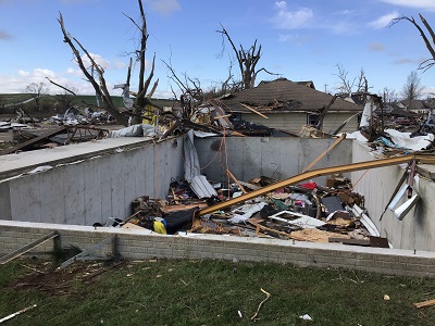
Tornado damage in Minden (April, 2024)
These long clusters of thunderstorms and wind can cause destruction similar to tornadoes, and therefore leave lots of homeowners and insurance companies with big repairs. “When insurance companies start paying out more in claims than what they’re bringing in in premiums, or when that number really shrinks, they’re going to raise their rates,” Sellmeyer said. Inflation is also a factor in increasing premiums, Sellmeyer said. Although overall inflation percentages decreased from a high of 7% in 2021 to just 2.4%, according to the U.S. inflation calculator, the cost of housing in the Midwest has increased by nearly 5% from last year.
Sellmeyer said an increase in construction material costs and continued supply chain issues are also increasing rates for most Iowans, and making it more difficult to mitigate damage from storms by building more durable, and costly, houses. The same effect is happening with auto insurance, Sellmeyer said. As cars become more complicated with more expensive repairs, insurance companies pay out more on a claim, which is increasing the overall premiums a company charges. Insurify data shows Iowa car insurance rates increased nearly 8% from September 2023.
But, Sellmeyer said the situation is not all bleak. Iowans can control certain elements of their policies to try to reduce premiums. Credit score, the age of a roof, location or the material of a house, are all granular factors at play in insurance premiums, which Sellmeyer encouraged Iowans to be aware of. “You can’t control Mother Nature, but if you can work on your credit score, it might help lower your insurance rates,” Sellmeyer said.
She said it’s also a good idea to go ahead make any repairs, like improve a roof or installing a railing, that a provider suggests because it is usually more expensive to have to switch providers. “My big push is : Get out that boring insurance policy and look at it and understand what you have,” Sellmeyer said.
Iowans can find other tips on the division’s consumer connection page.
A Wind Advisory is in effect for the area through this morning (Until 7-a.m.)
Scattered to widespread showers and storms move through the area today into tonight. Severe storms are possible, the greatest risk in southern Iowa and during the afternoon into evening hours. Severe weather threats include strong winds, hail, and a few tornadoes, but locally heavy rains are also possible and could result in urban ponding or flooding, especially if leaves begin to collect and block surface drainage. 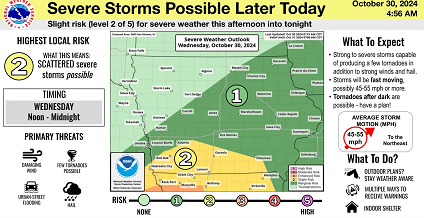
Additional thunderstorm chances arrive this weekend. Any potential for severe weather for the weekend will be better assessed in the coming days.
.SPOTTER INFORMATION STATEMENT…
Spotters may be needed this afternoon into tonight.
Today: **A Wind Advisory remains in effect until 7-a.m.** Cloudy w/showers & thunderstorms, especially around mid-day. Some of the storms could produce heavy rainfall. Temperature falling to around 59 by 5pm.S/SW winds 15-30 mph becoming NE this afternoon. New rainfall amounts between 1 and 2 inches possible.
Tonight: Showers and thunderstorms ending after midnight. Low around 39. N/NE winds becoming NW @ 10-25 mph. New rainfall amounts between a half and three quarters of an inch possible.
Tomorrow: Cloudy to partly cloudy & breezy. High near 50. W/NW @ 15-30 mph.
Tom. Night: Mostly clear, with a low around 30.
Friday: Sunny, with a high near 58.
Fri.Night: Partly cloudy w/a slight chance showers after midnight. Low around 38.
Saturday: A 50% chance of showers. High near 60.
Tuesday’s High in Atlantic was 82. The Low was 68. Last year on this date, the High in Atlantic was 42 and the Low was 19. The Record High for Oct. 30th in Atlantic was 84 in 1950. The Record Low was 1 in 1925. Sunrise today: 7:49; Sunset: 6:16.
(Radio Iowa) – The number of active burn bans in Iowa has dropped down to 57 counties (as of 5:30-p.m. Monday). State Fire Marshal Dan Wood says five counties ended their bans thanks to recent storms. “We’ve experienced a little bit of rain, but, you know, we’ve got a lot, lot of rain to go to catch up, to get everything, you know, sufficiently moist, where it’s not going to catch on fire as easy.” he says. Bremer County reported a grass fire along Highway 218 near Janesville Monday morning that was believed to be caused by a discarded cigarette. Wood says the dry conditions make a fire possible almost anywhere in counties with bans. A grass fire was also reported Monday afternoon near mile marker 51 off westbound I-80 in Cass County. Marne and Atlantic Fire responded and quickly had the flames extinguished.
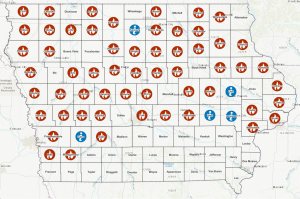
Counties w/an active burn ban are shown with a flame. Recently rescinded burn bans are shown in blue.
“With this being a rural state, and you know, our crops dry out at this time of year, every year, so that doesn’t help any either. And getting those out gives a lot of relief, but we still got to be mindful of there’s a lot of dry grass, a lot of dry crops and stubble out there. So everybody needs to be careful,” Wood says. He thinks most people have been avoiding open burning in the counties under a ban. “I think so. Haven’t heard too much of people, you know, going against the bans, a few here and there, but not much. I think people are pretty mindful once they get put on,” Wood says.
Johnson, Linn, Iowa, Hancock and Cass County recently lifted their burn bans after some rain.
Today: Increasing clouds. A high near 80. South/SW winds 25-45 mph.
Tonight: Mostly cloudy w/a slight chance of showers & thunderstorms after midnight. Low 65. S wind @ 20-45 mph.
Tomorrow: A slight chance of showers & thunderstorms. Some of the storms could produce heavy rainfall. The temperature will be falling throughout the day to around 57-degrees by 5pm. S/SW winds 20-40 mph. New rainfall amounts between 1 and 2 inches possible.
Tom. Night: Showers and possibly a thunderstorm. Low around 37. W/NW winds 15-25 mph. New rainfall amounts between 1/2-to 3/4 of an inch possible.
Thursday: Sunny & breezy. High near 50.
Thursday Night: Clear, with a low around 29.
Friday: Sunny, with a high near 57.
Monday’s High in Atlantic was 76. The Low was 58. Last year on this date, the High in Atlantic was 39 and the Low was 21. The Record High for Oct. 29th in Atlantic was 91 in 1927. The Record Low was 8 in 1895. Sunrise today: 7:48; Sunset: 6:19.
(Radio Iowa) – Most kids hate to go trick-or-treating while having to wear a winter coat that covers up their spooky costume, but that might be necessary in parts of Iowa this week.
Meteorologist Brooke Hagenhoff, at the National Weather Service, says the forecast for Halloween night calls for lows in the 30s in central and southern Iowa, and the upper 20s in northern Iowa.
“The good news is, those coldest temperatures won’t occur until very, very late, in most cases, after midnight on Thursday night,” Hagenhoff says, “but for prime trick-or-treating, kind of in that 6 to 8 PM time range, we’re looking at temperatures, just after sunset, should be dropping into the mid to low 40s.”

National Weather Service photo
Some areas of northern Iowa may be in the upper 30s during trick-or-treat time, meaning kids will need to wear warmer costumes or layer well under their outfits. Des Moines and a few other Iowa communities will hold trick-or-treating on Wednesday night, and while it’ll be cold, rain is also possible.
“There is a chance for some severe storms as well with these storms as they move through, so not just rain, but also lightning,” Hagenhoff says. “We want to make sure people are not just worried about getting wet, but also staying safe. Lightning can certainly be dangerous as we try to walk around getting that candy, so keep a close eye on the forecast for that.”
In many areas of the state, it’s been a glorious fall, with the leaves changing to stunning golds, yellows, oranges and reds. If you’re a leaf watcher, you might need to snap a few pictures right away, as those colorful leaves may soon be gone with the wind.
“We’re looking at today, wind gusts over 35 miles per hour possible, and then Tuesday, our warmest day is also our breeziest day, and we’re looking at wind gusts that could top 45 miles per hour in most places across the state,” Hagenhoff says, “so we’re going to be blowing a lot of leaves out of the trees.”
High temps today and tomorrow are forecast in the 70s and 80s, but a cold front is forecast to arrive with the rain on Wednesday, knocking highs by Thursday into the 40s and 50s.
(Radio Iowa) – An expert at Iowa State University’s Insect Zoo says there may actually be some science behind the folklore about how the thickness of a Woollybear caterpillar’s stripes can help predict the severity of the winter ahead. Ginny Mitchell, the insect zoo’s education program coordinator, says a fellow entomologist in New York studied the fuzzy creatures in the 1940s. “He sampled all of the woolly caterpillars in the area for nine years, and during that time, there was actually some correlation between the markings on the woolly caterpillar and the winter,” Mitchell says, “but that study had a very small sample size, so people do not consider it scientifically factual.”
The black-and-brown caterpillars are prevalent in Iowa right now as they’re looking for safe places to spend the winter. As the story goes, Mitchell says the thickness of the caterpillar’s center stripe is key in weather forecasting. “The rusty, kind of orange color, if that band is really big, that means we’re going to have a mild winter,” Mitchell says. “If the black parts of the woolly caterpillar are very large, it’s going to be a more severe winter. If there is more hair on the woolly caterpillar, then that means that it’s going to be a more severe winter.” 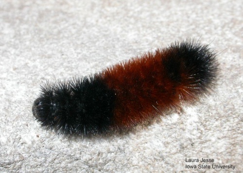
There are also theories that if the caterpillar is crawling south when you find it, it’s trying to flee the looming northern cold, and the reverse, if it’s heading north, a mild winter is ahead. At least two communities — Vermilion, Ohio and Banner Elk, North Carolina — have fall festivals devoted to the alleged prognosticating abilities of the woolly bear caterpillar. One remarkable fact, Mitchell says these fuzzy critters hibernate during the wintertime and their bodies contain a sort of natural antifreeze. “Say you’re out raking leaves or moving some brush and you find one, it will kind of look like it’s dead. It’ll be curled up like a ‘C’ and it won’t be moving very much,” Mitchell says, “but if you take it inside and you warm it up, then it’ll start to move.”
There are reports of woolly bear caterpillars surviving temperatures as low as 90-degrees below zero, even spending an entire winter frozen in an ice cube, to emerge just fine in the spring. Once temperatures warm up for the season, it will create a cocoon and emerge a few weeks later as an Alexandra or Isabella tiger moth.
Today: Partly sunny & windy, High near 76. Winds S @ 15-to around 30 mph.
Tonight: Partly cloudy & breezy. Low around 64. S @ 15-30 mph.
Tomorrow: Mostly sunny & windy. High near 81. S @ 20-45 mph.
Tom. Night: Showers likely and possibly a thunderstorm after midnight. Low 57. S @ 20-40 mph.
Wednesday: Showers & possibly a thunderstorm. Windy. High near 70.
Wed.y Night: Showers likely and possibly a thunderstorm. Low around 33.
Thursday: Sunny, with a high near 51.
Sunday’s High in Atlantic was 69. The Low was 41. Last year on this date, the High in Atlantic was 36 and the Low was 29. The Record High for Oct. 28th in Atlantic was 83 in 1922. The Record Low was 2 in 1925. Sunrise today: 7:46; Sunset: 6:20.


