
(Radio Iowa) – A Red Flag warning is posted today (Monday) for most of Iowa and residents are warned not to do any open burning, as vegetation is very dry and winds will be gusting. Meteorologist Kristy Carter, at the National Weather Service, says high temperatures may climb into record or near-record territory in the 60s and 70s this afternoon. “We’re even going to be approaching the all-time February record high at some locations,” Carter says. “We’re going to combine that with some extreme fire danger as well. So that warmth with those strong winds, it’s going to lead to those extreme fire weather conditions, so certainly burning is not recommended today.” She says any fires that are set could quickly spread and burn out of control.
A big turnaround in temperatures is coming as forecasters say we’ll see lows across Iowa tomorrow night in the single digits and teens with snow possible. “Our temperatures are going to drop drastically through the day,” Carter says. “We’ll start warm, but by the afternoon into evening, temperatures are going to plummet. Our winds are also going to increase as well, so that’s going to send our wind chills down toward zero or below zero even by Wednesday morning.” Carter says the mid-week cold snap won’t last long with a return to warmer temperatures to welcome the first weekend of March.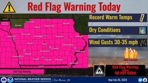
“On Wednesday, we’ll actually be closer to typical highs for the month of February in the mid 20s to mid 30s, but that will be very short lived,” Carter says. “We’re heading into the 50s by Thursday and then we’ll be approaching records again by the weekend.” The first day of Spring is March 19th.
Emergency Managers remind residents not to throw out cigarettes from moving vehicles and to discontinue burning yard waste, piled tree debris, grass/agriculture ground and set asides or other items during this ban. Small recreational campfires are permitted only if they’re conducted in a fireplace of brick, metal, or heavy one-inch wire mesh, however extreme caution should be taken. Any campfire not in an outdoor fireplace is prohibited.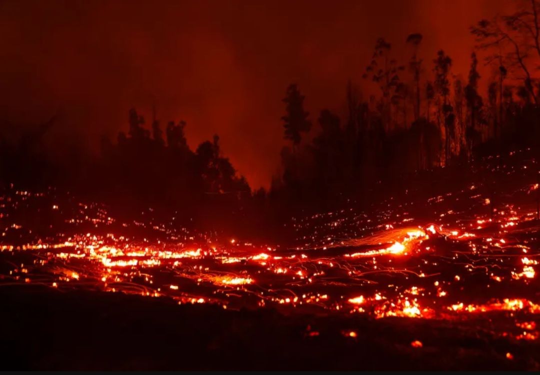
Officials says the open burn bans are in effect until dangerous fire conditions are no longer present. For more information contact the State Fire Marshal’s Office at 515-725-6145 or go to https://dps.iowa.gov/divisions/state-fire-marshal/burn-bans
Today: **RED FLAG WARNING for critical fire weather conditions (low humidity & strong winds) from 9-a.m. until 6-p.m.** Sunny & breezy. High near 75. S winds @ 10-20 shifting to the W/SW & gusting to around 25.
Tonight: Mostly clear, with a low around 42. S/SW @ 10-20 mph.
Tomorrow: Mostly sunny & windy, with a high near 63. S-N/NW @ 15-25 mph.
Tom.Night: A 40% chance of snow through midnight. Low around 12. N/NW @ 20-45 mph. New snow accumulation of less than a half inch possible.
Wednesday: A 20% chance of snow before 7am. Otherwise Mostly sunny & windy, with a high near 32.
Thursday: Sunny & windy, with a high near 52.
Sunday’s High in Atlantic was 69 (one degree shy of the record high). The Low was 19. Last year on this date, the High in Atlantic was 72 and the Low was 19. The Record High for Feb. 26th was 72 degrees, set in 1896. The Record Low was -28, in 1963. Sunrise: 6:59. Sunset: 6:06.
(Southwest Iowa) – Firefighters across western and central Iowa were kept busy, today (Sunday), knocking down field and brush fires, some of which resulted from controlled burns, while the cause of other incidents were unknown. The Red Oak Fire Department reported on social media, that around 5:17-p.m, Sunday, firefighting crews from the Elliott, Red Oak and Grant FD’s were dispatched to the Justin & Angel Paul property at 1849 140th Street, for a reported brush pile fire that had gotten out of control. Crews were able to contain the fire and terminated fire/ground operations at 5:50-p.m. No injuries were reported.
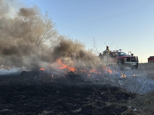
Sunday evening fire in Montgomery County (Red Oak FD pics)
Less than three-hours after the fire Sunday evening was reported, Red Oak Fire crews were dispatched to property owned by Thomas and Beth Falk, at 1767 165th St, for a reported grass fire. First arriving Fire crews reported one-acre of grass on fire. Mutual Aid was automatically dispatched requesting the Stanton and Elliott Fire Departments, but those crews were then disregarded.
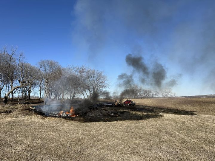
Sunday afternoon fire
Fire officials say the property owner had been conducting property clean-up and had a burn pit in use. It is believed that embers from this activity started the grass on fire. No injuries reported. Fire/ground operations were terminated at approximately 3:10-p.m.
In Story County, the Kelley Fire Department responded to a fire in a cornfield near 510th Avenue and 300th Street. According to the Story County Sheriff’s Office, the fire grew to 10,000 square feet. A nearby house was not damaged, and no injuries have been reported at this time.
Conditions on Monday may be favorable for more fires with gusty winds and dry conditions. Most of the state of Iowa will be under a Red Flag Warning issued by the National Weather Service in Des Moines from 9 a.m. to 6 p.m. Monday.
A Red Flag Warning means that critical fire weather conditions are either occurring now, or will shortly. A combination of strong winds, low relative humidity, and warm temperatures can contribute to extreme fire behavior.
[Red Oak, Iowa] – Montgomery County Emergency Management Director Brian Hamman today (Sunday), said “An open burn ban will go into effect Monday, February 26, 2024 at 8:00am, for all areas and jurisdictions within Montgomery County. The ban prohibits all open and controlled burning in Montgomery County, including all incorporated city limits within the county.”
Record high temperatures, limited to no moisture and continued drought conditions has created dangerous fire conditions throughout the entire area. Extended forecast outlooks show well above normal temperatures as well as extremely windy conditions causing concern that any outdoor fire will become large and out of control in a very short amount of time.
“Citizens are reminded to not throw out cigarettes from moving vehicles and to discontinue burning yard waste, piled tree debris, grass/agricultural ground and set asides or other items during this ban. Small recreational campfires are permitted only if they are conducted in a fireplace of brick, metal or heavy one-inch wire mesh, however extreme caution should be taken. Any campfire not in an outdoor fireplace is prohibited,” according to Hamman.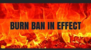
Violation of a burn ban can subject a person to criminal charges as well as civil liabilities for any damages, losses or injuries resulting from the fire. The open burn ban is anticipated to remain in effect until the county receives substantial precipitation alleviating the increased fire danger risk.
Today: Sunny, with a high near 64. Calm wind becoming west northwest 5 to 8 mph in the morning.
Tonight: Clear, with a low around 37. Calm wind becoming south southeast 5 to 7 mph after midnight.
Monday: Sunny, with a high near 75. Breezy, with a southwest wind 8 to 17 mph, with gusts as high as 28 mph.
Tuesday: Mostly sunny, with a high near 65. Windy, with a south wind 6 to 11 mph becoming north northwest 18 to 23 mph in the afternoon. Winds could gust as high as 29 mph.
Tuesday Night: A chance of rain and snow before 9pm, then a chance of snow. Mostly cloudy, with a low around 11. Windy. Chance of precipitation is 30%.
Wednesday: Mostly sunny, with a high near 30. Windy.
Saturday’s High in Atlantic was 58. The Low was 15. Last year on this date, the High in Atlantic was 41 and the Low was 9. The Record High for Feb. 25th was 70 degrees, set in 1995. The Record Low was -14, in 2010. Sunrise: 7:01. Sunset: 6:05.
Today: Sunny & breezy. High near 58. S/SW winds 10-25 mph.
Tonight: Mostly clear, with a low around 31. S/SW winds 5 to 10 mph.
Sunday: Sunny, with a high near 63. West wind 5 to 10 mph becoming north northwesterly.
Sunday Night: Clear, with a low around 37.
Monday: Sunny & breezy. High near 73.
Monday Night: Partly cloudy, with a low around 42.
Tuesday: A slight chance of rain before noon, then a slight chance of snow. High near 59.
Tuesday Night: A 30% chance of snow. Low around 15.
Friday’s High in Atlantic was 56. The Low was 15. Last year on this date, the High in Atlantic was 21 and the Low was 4. The Record High for Feb. 24th was 76 degrees, set in 1930. The Record Low was -15, in 1894. Sunrise: 7:02. Sunset: 6:04.
(Iowa Capital Dispatch) – Iowa’s long-running drought has eased since a month ago but is still by far the worst it’s been leading into the growing season in the past three years, according to the U.S. Drought Monitor. The area of the state that is suffering from extreme drought — the second-worst classification of the Drought Monitor — is about half what it was in December but still encompasses a vast area of northeast Iowa. That includes some or all of more than two dozen counties.
About three-quarters of the state has some measure of drought. The exceptions are a wide area of northwest Iowa and parts of far southern and far eastern Iowa. Drought conditions have persisted in the state since July 2020 — the longest stretch since the 1950s, according to the Iowa Department of Natural Resources. The dryness peaked in September 2023.
Many Iowa rivers have very low flow, according to U.S. Geological Survey data. In Osceola, residents have been urged to conserve water as the town’s water supply — West Lake — has dwindled. But the city reported early this month that the lake’s level had stabilized.
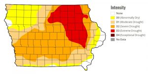
The area of extreme drought in Iowa has shrunk considerably in the past month. (Courtesy of U.S. Drought Monitor)
(Omaha/Valley, NE) – The National Weather Service in Omaha says the warm weather we’ve been experiencing the past few days in southeastern Nebraska and Southwestern Iowa, is here to stay through the weekend. The Weather Service said also, a “Very high fire danger will persist for the next few days.”
In the Hazardous Weather Outlook issued by the NWS in Des Moines, officials said dry and breezy conditions will lead to potential very high fire danger conditions in at least a portion of the area each day. The highest potential may be in southeast Nebraska on Monday, where some areas may see extreme fire danger.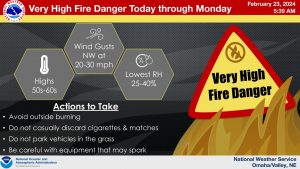
The Iowa Department of Public Safety reports only Harrison County in our listening area, has a Burn Ban in place. That order was issued in late September, 2023, and remains in effect until further notice.
(Radio Iowa) – Hopes raised in January for a turnaround in the state drought situation went away as February turned dry. Iowa D-N-R Hydrologist, Tim Hall says the latest Drought Monitor Report shows that. “There’s a significant chunk of the state of Iowa right, now about almost 20 percent of the state that’s rated by the drought monitor as extreme drought in northeast Iowa,” Hall says. He says that runs from Linn and Benton County north all the way up to the Minnesota border. And 56 percent of the state is rated in severe drought.
“In the wintertime when nothing’s growing and we don’t think about water use, it’s kind of easy to stop remembering where we are. But we still have more than half of the state rated in severe drought. And that’s a problem moving into the spring months and the growing season,” Hall says. He says the January snow was good, but when it melted in February, it illustrated how dry things are. “We had two feet of snow in the state over large parts of the state, and it all melted fairly quickly, and we saw zero instances of flooding,” Hall says. “And that just tells me that the soils are so incredibly dry.”
Hall says the dry soil sucked up most of the snow melt and there was not a lot left to refill empty streams and rivers. “To have that amount of snow melt off and have no even localized flooding is a very surprising thing,” he says. The snow came in January which was one inch above normal for precipitation. But Hall says all that surplus has gone away in what may end up being the driest February on record. “So the pattern of wet month, dry month, wet month, dry month, that doesn’t help us much. We need wet month, wet month, wet month, wet month,” Hall says.
He says we typically get a lot more rain in the spring months, and we’ll need that to work toward getting rid of the drought.


