
Today: Sunny, with a high near 71. Northeast wind 5 to 9 mph becoming south in the afternoon.
Tonight: Mostly clear, with a low around 51. South wind around 7 mph.
Columbus Day: A 20 percent chance of showers and thunderstorms after 10am. Mostly cloudy, with a high near 70. Breezy, with a south wind 8 to 18 mph, with gusts as high as 30 mph.
Monday Night: A 20 percent chance of showers before 1am. Partly cloudy, with a low around 54. South wind 11 to 14 mph, with gusts as high as 25 mph.
Tuesday: Mostly sunny, with a high near 73. South wind 10 to 14 mph, with gusts as high as 20 mph.
Tuesday Night: A 30 percent chance of showers after 1am. Mostly cloudy, with a low around 47. New precipitation amounts of less than a tenth of an inch possible.
Wednesday: A 40 percent chance of showers before 1pm. Partly sunny, with a high near 54. Breezy.
Wednesday Night: Areas of frost after 5am. Otherwise, mostly clear, with a low around 32.
Today: Mostly Sunny. High 70 W-SW winds at 10-20.
Tonight: Mostly clear. Low 54. SW-N @ 5-10.
Tomorrow: Mo. Sunny. High 64. E/NE @ 5-10 becoming SE during the afternoon.
Tom. Night: P/Cldy. Low 49.
Monday: Partly Sunny w/a 30% chance of showers. High 68.
Tuesday: P/Sunny. High 73.
Today: P/Cldy. High 62. NW @ 10-20.
Tonight: Mostly clear. Low 34. Winds light & variable.
Tomorrow: Areas of fog in the morning; Otherwise P/Cldy. High 70. SW @ 10-15
Sunday: P/Cldy. High 72.
Monday (Columbus Day): P/Cldy to Cldy w/scattered showers. High 72.
Thursday’s High in Atlantic was 66. Our 24-hour Low (ending at 7-a.m. today) was 38. We received .2” rain (two-tenths of an inch) Thursday at the KJAN Studios. Last year on this date, our High in Atlantic was 77 and the low was 54. The Record High in Atlantic on this date was 88 in 1938. The Record Low was 16 in 1952 & 2012.
The American Red Cross is preparing to respond as Hurricane Matthew slams into the southeast coast of the country. Iowa Region Red Cross spokesperson, Kara Kelly, says national officials are checking with the states that are not in the path of the storm to line up help. “There is a major call for volunteers nationwide to go anywhere from South Carolina to Florida to help, so we are making those opportunities available to folks. But at the same time….we still have a flooding operation happening in north and eastern Iowa and we still want to make sure we take care of folks at home too,” Kelly says.
Two Iowa volunteers from Ankeny may be heading out to help with the Hurricane recovery sometime today (Friday). She says they were actually scheduled to head out Thursday, but the airport in Orlando closed and they are not waiting. Kelly says if you are interested in volunteering for the Red Cross the first step is to register. “I would say now is the time to get signed up, because if it becomes a very significant operation — which we anticipate it could be — we could start sending people pretty quickly. And sometimes that training could happen pretty quickly,” Kelly says. “The best thing to do at this point is to go to Red-Cross-dot-org and sign up to get into the system. At the very minimum you can take some of those on-line trainings and then we will see what happens.”
She says it has been a significant amount of time since we’ve seen a hurricane of this magnitude. “We’re just asking people to be prepared if you’ve got friends or families in those areas. Make sure you contact them, you know where they are going to be, and hopefully they are heeding those warnings to evacuate,” Kelly says.
In Florida alone where some areas could get as much as 10 inches of rain, the Red Cross is prepared to open or support as many as 100 evacuation shelters and has more than 30 emergency response vehicles standing by. In South Carolina, the Red Cross plans to open or support 19 evacuation shelters and dozens of additional shelters are ready to open in Georgia and North Carolina.
(Radio Iowa)
345 AM CDT FRI OCT 7 2016
EARLY THIS MORNING…CLOUDY…COLDER. NORTHWEST WIND 10 TO 15 MPH WITH GUSTS TO AROUND 25 MPH.
TODAY…SUNNY. HIGH IN THE LOWER 60S. NORTHWEST WIND 5 TO 10 MPH.
TONIGHT…CLEAR. LOW IN THE LOWER 40S. SOUTHWEST WIND NEAR 5 MPH.
SATURDAY…SUNNY. HIGH IN THE UPPER 60S. SOUTHWEST WIND 5 TO 15 MPH WITH GUSTS TO AROUND 25 MPH.
SATURDAY NIGHT…CLEAR. LOW IN THE LOWER 40S. SOUTHWEST WIND NEAR 10 MPH.
SUNDAY…SUNNY. HIGH AROUND 70. SOUTH WIND NEAR 10 MPH.
COLUMBUS DAY…PARTLY SUNNY WITH A 20 PERCENT CHANCE OF SHOWERS. HIGH AROUND 70.
THE SEVERE STORMS PREDICTION CENTER IN NORMAN, OK., HAS ISSUED A TORNADO WATCH IN EFFECT UNTIL 9-P.M. FOR THE FOLLOWING COUNTIES IN SOUTHWEST IOWA….ADAIR ADAMS CASS CLARKE DECATUR FREMONT LUCAS MADISON MILLS MONTGOMERY PAGE POTTAWATTAMIE RINGGOLD TAYLOR UNION WARREN.
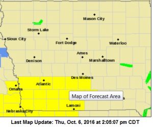
Tornado Watch until 9-p.m for counties in yellow
A FEW TORNADOES LIKELY WITH A COUPLE INTENSE TORNADOES POSSIBLE. WIDESPREAD LARGE HAIL AND ISOLATED VERY LARGE HAIL EVENTS TO 3 INCHES IN DIAMETER LIKELY. ISOLATED DAMAGING WIND GUSTS TO 70 MPH POSSIBLE.
PROBABILITY TABLE:
PROB OF 2 OR MORE TORNADOES : 70%
PROB OF 1 OR MORE STRONG /F2-F5/ TORNADOES : 40%
PROB OF 10 OR MORE SEVERE WIND EVENTS : 20%
PROB OF 1 OR MORE WIND EVENTS > 75 MPH : 20%
PROB OF 10 OR MORE SEVERE HAIL EVENTS : 90%
PROB OF 1 OR MORE HAIL EVENTS > 2 INCHES : 70%
PROB OF 6 OR MORE COMBINED SEVERE HAIL/WIND EVENTS : >95%
MILLS IA-CASS NE-OTOE NE-SARPY NE-
1130 AM CDT THU OCT 6 2016
…SIGNIFICANT WEATHER ADVISORY FOR WESTERN MILLS…CASS (NE)…
SOUTHWESTERN SARPY AND NORTHWESTERN OTOE COUNTIES in NE UNTIL 1215 PMCDT…
AT 1129 AM CDT…DOPPLER RADAR WAS TRACKING STRONG THUNDERSTORMS ALONG A LINE EXTENDING FROM 7 MILES NORTH OF BENNET TO 4 MILES WEST OF AVOCA. MOVEMENT WAS NORTHEAST AT 45 MPH. NICKEL SIZE HAIL WILL BE POSSIBLE WITH THESE STORMS.
LOCATIONS IMPACTED INCLUDE…
PLATTSMOUTH…LOUISVILLE…WEEPING WATER…ELMWOOD…MURRAY…
AVOCA…MURDOCK…NEHAWKA…EAGLE…MANLEY…
ALVO AND PLATTE RIVER STATE PARK.
THIS INCLUDES HIGHWAY 75 IN NEBRASKA NEAR MILE MARKER 73.
The grassland/field fire Danger rating will remain HIGH in Shelby County, until further notice. Emergency Management Coordindator Bob Seivert said Thursday (today), while some rain has fallen and more is likely, the amount of crops and vegetation in the fields is significant, and those elements can dry out in a matter of hours, creating a potential fast burning situation.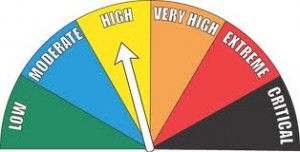
Today: Mostly cloudy w/scattered thunderstorms late this morning; Thunderstorms becoming more numerous this afternoon. Some may be severe later today. High 73. SE @ 10-20. Chance of thunderstorms 60 percent.
Tonight: Mostly cloudy w/showers & thunderstorms diminishing around midnight. Low 42. NW @ 10-20.
Friday: P/Cldy. High 62. NW @ 10-20.
Friday Night: Clear. Low around 40. Southwest wind near 5 mph.
Saturday: P/Cldy. High 68. SW @ 10-20 w/gusts to 25.
Saturday Night: Clear. Low in the mid 40s.
Sunday: Sunny. High in the lower 70s.
Wednesday’s High in Atlantic was 73. Our 24-hour Low (ending at 7-a.m. today) was 51. Last year on this date, our High in Atlantic was 73 and the low was 50. The Record High in Atlantic on this date was 91 in 1963 & 1997. The Record Low was 15 in 2012.
AREA COUNTIES: CRAWFORD-CARROLL-AUDUBON-GUTHRIE-DALLAS-CASS-ADAIR-MADISON-ADAMS-UNION-TAYLOR-RINGGOLD…
SEVERE THUNDERSTORMS ARE POSSIBLE LATE THIS AFTERNOON AND EVENING. THREATS ARE TORNADOES…DAMAGING WINDS…AND LARGE HAIL. A BRIEF PERIOD OF HEAVY RAINFALL IS ALSO POSSIBLE.
STORM SPOTTER ACTIVATION MAY BE REQUIRED ACROSS WESTERN & S.W. IA THIS AFTERNOON.
AREA COUNTIES: MONONA-HARRISON-SHELBY-POTTAWATTAMIE-MILLS-MONTGOMERY-FREMONT-PAGE…
STRONG TO SEVERE THUNDERSTORMS WILL LIKELY DEVELOP LATE THIS AFTERNOON AND CONTINUE INTO THE EARLY EVENING HOURS…MAINLY ALONG AND SOUTH OF INTERSTATE 80. DEEP LAYER WIND SHEAR COUPLED WITH STRONG INSTABILITY WILL BE IN PLACE FOR SUPERCELL DEVELOPMENT WITH LARGE HAIL AND DAMAGING WINDS THE MAIN THREATS. GIVEN THE STRONG ENVIRONMENTAL SHEAR…A FEW STORMS MAY BECOME TORNADIC IN NATURE IN EXTREME SOUTHEAST NEBRASKA AND SOUTHWEST IOWA.


