
EARLY THIS MORNING…PARTLY CLOUDY. NORTHEAST WIND NEAR 5 MPH.
TODAY…PARTLY SUNNY. HIGH IN THE UPPER 60S. NORTHEAST WIND NEAR 10 MPH.
TONIGHT…MOSTLY CLOUDY WITH A 20 PERCENT CHANCE OF LIGHT RAIN. LOW IN THE MID 40S. NORTH WIND 5 TO 10 MPH.
THURSDAY…PARTLY SUNNY. A 20 PERCENT CHANCE OF LIGHT RAIN THROUGH MID MORNING. COOLER. HIGH IN THE UPPER 50S. NORTH WIND 5 TO 10 MPH.
FRIDAY…MOSTLY SUNNY. HIGH IN THE LOWER 60S. SOUTH WIND NEAR 10 MPH.
FRIDAY NIGHT…MOSTLY CLEAR. LOW IN THE LOWER 40S.
SATURDAY…SUNNY. HIGH IN THE UPPER 60S.
Today: Areas of fog this morning; P/Cloudy. High 68. NW @ 10-15.
Tonight: Mo. Cldy. Low 43.
Tomorrow: Mo. Cldy w/scattered light showers. High 65. N @ 10-15.
Thursday: P/Cldy to Cldy w/a chance of morning showers. High near 60.
Friday: P/Cldy. High 64.
Monday’s High in Atlantic of 87 tied the record set for Oct. 17th set in 1947. Our 24-hour Low (ending at 7-a.m. today) was 56. Last year on this date, our High in Atlantic was 69 and the low was 43. The Record High in Atlantic on this date was 86 in 2003. The Record Low was 17 in 1952.
347 AM CDT TUE OCT 18 2016
EARLY THIS MORNING…MOSTLY CLEAR. COOLER. NORTHWEST WIND 5 TO 10 MPH.
TODAY…SUNNY…COOLER. HIGH IN THE UPPER 60S. NORTHWEST WIND 5 TO 10 MPH.
TONIGHT…MOSTLY CLEAR UNTIL EARLY MORNING THEN BECOMING MOSTLY CLOUDY. LOW IN THE UPPER 40S. NORTHWEST WIND NEAR 5 MPH SHIFTING TO THE NORTHEAST AFTER MIDNIGHT.
WEDNESDAY…PARTLY SUNNY. HIGH IN THE UPPER 60S. NORTHEAST WIND NEAR 10 MPH.
WEDNESDAY NIGHT…MOSTLY CLOUDY WITH A 20 PERCENT CHANCE OF LIGHT RAIN. LOW IN THE LOWER 40S. NORTH WIND 5 TO 10 MPH.
THURSDAY…MOSTLY SUNNY. COOLER. HIGH IN THE UPPER 50S. NORTH WIND 5 TO 15 MPH.
FRIDAY…MOSTLY SUNNY. HIGH IN THE MID 60S.
FRIDAY NIGHT…MOSTLY CLEAR. LOW IN THE LOWER 40S.
The Shelby County Emergency Management Agency says the field and grassland Fire Danger category will remain HIGH until at least Thursday (Oct. 20th), when the rating may be upgraded to EXTREME. In the mean time, authorities are asking anyone who plans to conduct controlled burns to contact their local fire chief, first. Be sure and call 755-2124 also, with the location of your burn, so dispatchers can gather logistical data. 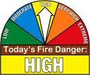
If conditions continue to deteriorate and an EXTREME Fire Danger Warning is issued, absolutely no outdoor burning would be permitted unless you have a signed permit from the local Fire Chief. Fires on Extreme days can grow rapidly and pose a risk to the Health and Safety of the Community. If you have any questions please call 712-755-2124.
Today: Areas of fog possible early; P/Cloudy. High 81. S @ 10-20.
Tonight: Mo. Cldy w/a chance of showers. Low 48. N @ 10-15.
Tomorrow: P/Cldy. High 68. NW @ 10-15.
Wednesday: P/Cldy w/scattered light rain. High 65.
Thursday: P/Cldy to Cldy w/a chance of morning showers. High 60.
Sunday’s High in Atlantic was 82. We also received a Trace of precipitation. Our 24-hour Low (ending at 7-a.m. today) was 59. Last year on this date, our High in Atlantic was 58 and the low was 35. The Record High in Atlantic on this date was 87 in 1947. The Record Low was 12 in 1976.
The National Weather Service offices on Omaha and Des Moines have cancelled the Dense Fog Advisory for most of the KJAN listening area. The Advisory remains in effect until 9-a.m. for Crawford and Carroll Counties, and until 10-a.m. for Harrison County.
ADAIR-ADAMS-TAYLOR-MILLS-MONTGOMERY-FREMONT-PAGE COUNTIES; 331 AM CDT MON OCT 17 2016 — DENSE FOG ADVISORY IS CANCELLED. THE NATIONAL WEATHER SERVICE IN OMAHA/VALLEY HAS CANCELLED THE DENSE FOG ADVISORY. CURRENT INDICATIONS SUGGEST THAT WIDESPREAD DENSE FOG IS NOT LIKELY THIS MORNING, SO THE PREVIOUSLY ISSUED ADVISORY HAS BEEN CANCELLED.

Dense Fog Advisory for counties in gray.
A DENSE FOG ADVISORY REMAINS IN EFFECT UNTIL 9-A.M. FOR SAC-CRAWFORD-CARROLL-GREENE-AUDUBON-GUTHRIE- AND CASS COUNTIES, AND UNTIL 10-A.M. FOR HARRISON-SHELBY AND POTTAWATTAMIE COUNTIES.
AREA COUNTIES: SAC-CRAWFORD-CARROLL-AUDUBON-GUTHRIE-CASS-ADAIR-ADAMS-TAYLOR-MONONA-HARRISON-SHELBY-POTTAWATTAMIE-MILLS-MONTGOMERY-FREMONT AND PAGE….
DENSE FOG ADVISORY IN EFFECT FROM 2 AM TO 9 AM CDT MONDAY…
* VISIBILITY…VISIBILITY OF ONE QUARTER MILE OR LESS CAN BE EXPECTED…ESPECIALLY BETWEEN 2 AM AND 8 AM MONDAY MORNING.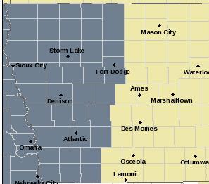
* IMPACTS…TRAVEL MAY BE DIFFICULT AND MUCH SLOWER DUE TO VERY LOW VISIBILITIES. ALLOW EXTRA TIME TO REACH YOUR DESTINATION SAFELY. FOLLOW FOG SAFETY RULES AND USE LOW BEAM HEADLIGHTS. CHECK THE LATEST VISIBILITY IN YOUR AREA PRIOR TO HEADING OUT OVERNIGHT AND EARLY MONDAY MORNING.
PRECAUTIONARY/PREPAREDNESS ACTIONS…
A DENSE FOG ADVISORY MEANS VISIBILITIES WILL FREQUENTLY BE REDUCED TO LESS THAN ONE QUARTER MILE. IF DRIVING…SLOW DOWN…USE YOUR LOW BEAM HEADLIGHTS…AND LEAVE PLENTY OF DISTANCE AHEAD OF YOU. BE ESPECIALLY CAUTIOUS NEAR SCHOOL BUS STOPS…INTERSECTIONS AND RAILROAD CROSSINGS AS ONCOMING VEHICLES AND TRAINS MAY BE HIDDEN FROM VIEW BY THE FOG.
Today: **A Dense Fog Advisory is in effect this morning** Areas of dense fog before 11am. Otherwise, mostly cloudy, with a high near 79. Wind becoming south southeast 5 to 15 mph this morning, with gusts as high as 20 mph.
Tonight: Patchy fog after 4am. Otherwise, mostly cloudy, with a low around 63. South southwest wind 5 to 10 mph.
Monday: Patchy fog before 8am. Otherwise, mostly sunny & warmer, with a high near 83. Breezy, with a south wind 5 to 15 mph, with gusts as high as 30 mph.
Tuesday: Sunny and cooler, with a high near 70.
Wednesday: Partly sunny, with a high near 65.
Thursday: Partly sunny, with a high near 58.
(Updated 7-a.m. to expand time frame for western/s.w. IA)
A DENSE FOG ADVISORY REMAINS IN EFFECT UNTIL 11 AM TODAY (SUNDAY) FOR HARRISON-SHELBY-POTTAWATTAMIE-MILLS-MONTGOMERY-FREMONT AND PAGE COUNTIES, AND UNTIL 9-A.M. FOR CASS AND OTHER AREA COUNTIES.
* VISIBILITY…AVERAGING ONE QUARTER MILE OR LESS THROUGH MID MORNING.
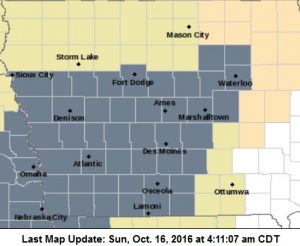
Dense Fog Advisory for counties in gray.
* IMPACTS…THE REDUCED VISIBILITIES WILL MAKE FOR HAZARDOUS DRIVING CONDITIONS IF CAUTION IS NOT TAKEN. TRAVEL IS LIKELY TO BE CHALLENGING AT TIMES THROUGHOUT THE KJAN LISTENING AREA.
PRECAUTIONARY/PREPAREDNESS ACTIONS…
A DENSE FOG ADVISORY MEANS VISIBILITIES WILL FREQUENTLY BE REDUCED TO LESS THAN ONE QUARTER MILE. IF DRIVING… SLOW DOWN… USE YOUR HEADLIGHTS… AND LEAVE PLENTY OF DISTANCE AHEAD OF YOU.


