
MONONA-HARRISON-SHELBY-POTTAWATTAMIE-MILLS-MONTGOMERY-FREMONT-PAGE COUNTIES…PATCHY DENSE FOG FOR THE MORNING DRIVE.
PATCHY DENSE FOG HAS DEVELOPED THIS MORNING AND WILL PERSIST
THROUGH ABOUT 9 AM. VISIBILITIES OF A QUARTER MILE OR LESS ARE
POSSIBLE IN SOME AREAS. THE PATCHY NATURE OF THE DENSE FOG WILL
MAKE FOR SOME DIFFICULT DRIVING SITUATIONS AS VISIBILITIES COULD
VARY GREATLY OVER SHORT DISTANCES.
PLEASE USE CAUTION WHILE DRIVING THIS MORNING…AND BE PREPARED
FOR RAPID REDUCTIONS IN VISIBILITIES.
Early This Morning: Mostly cloudy. Colder. Areas of fog. Northeast wind near 5 mph.
Today: Mostly sunny. Areas of fog in the morning. High in the upper 60s. South wind near 5 mph increasing to 10 to 15 mph in the afternoon.
Tonight: Mostly clear. Warmer. Low in the mid 50s. South wind 5 to 10 mph with gusts to around 20 mph.
Friday: Mostly sunny. Breezy…warmer. High around 80. South wind 10 to 15 mph increasing to southwest 20 to 25 mph in the afternoon. Gusts up to 40 mph.
Friday Night: Partly cloudy. Low in the mid 50s. Southwest wind 5 to 10 mph. Gusts up to 25 mph through midnight.
Saturday: Mostly sunny. Cooler. High around 70. Southwest wind 5 to 10 mph.
Saturday Night: Mostly cloudy. Cooler. Low in the mid 40s.
Sunday: Mostly sunny. High in the mid 60s.
There’s no snow in the forecast just yet, but 19 years ago on this date, many Iowans were digging out from one of the heaviest October snowfalls in the state’s history. The major winter storm spread across much of southern and central Iowa on October 26, 1997. National Weather Service records show the heaviest snowfall accumulations included 11.3 inches at Knoxville in Marion County and 13 inches southwest of Mineola in Pottawattamie County.
Tens of thousands of homes and businesses lost electricity as snow laden trees fell onto power lines. On this morning 19 years ago, temperatures plummeted to just nine-degrees above zero in Atlantic and Guthrie Center — the coldest Iowa temperature recorded so early in the season since 1972.
(Radio Iowa)
Today: Cloudy to P/Cldy. High 63. NW @ 10-20.
Tonight: P/Cldy. Low 40.
Tomorrow: Area of fog, early; P/Cldy. High near 70. S @ 10-15.
Friday: P/Cldy. High near 80.
Saturday: Cldy. High 65.
Tuesday’s High in Atlantic was 66. We received .07” of an inch of rain overnight into early this morning, here at the KJAN studios. Our 24-hour Low (ending at 7-a.m. today) was 49. Last year on this date, our High in Atlantic was 62 and the low was 31. The Record High in Atlantic on this date was 84 in 1956. The Record Low was 14 in 1980.
352 AM CDT WED OCT 26 2016
EARLY THIS MORNING…LIGHT SHOWERS AND SCATTERED THUNDERSTORMS. WARMER. SOUTH WIND 10 TO 15 MPH. CHANCE OF PRECIPITATION 80 PERCENT.
TODAY…PARTLY SUNNY. HIGH IN THE LOWER 60S. NORTHWEST WIND 10 TO 15 MPH.
TONIGHT…PARTLY CLOUDY. COLDER. LOW IN THE MID 40S. NORTH WIND NEAR 10 MPH.
THURSDAY…SUNNY. HIGH IN THE UPPER 60S. SOUTH WIND NEAR 5 MPH INCREASING TO 5 TO 15 MPH IN THE AFTERNOON.
FRIDAY…MOSTLY SUNNY. BREEZY. HIGH IN THE UPPER 70S. SOUTHWEST WIND 10 TO 20 MPH WITH GUSTS TO AROUND 30 MPH.
FRIDAY NIGHT…PARTLY CLOUDY. LOW IN THE UPPER 50S.
SATURDAY...MOSTLY SUNNY. HIGH AROUND 70.
Today: Mostly Cloudy w/scattered showers & thunderstorms. High 60. SE @ 15-25.
Tonight: Showers & occasional thunderstorms. Low 53. SE-NW @10-15.
Tomorrow: Showers ending early; P/Cldy. High 63. N @ 10-15.
Thursday: P/Cldy. High near 70.
Friday: P/Cldy, windy & warmer. High 78.
Monday’s High in Atlantic was 64. Our 24-hour Low (ending at 7-a.m. today) was 35. Last year on this date, our High in Atlantic was 64 and the low was 29. The Record High in Atlantic on this date was 85 in 1891 & 1940. The Record Low was 14 in 1892.
352 AM CDT TUE OCT 25 2016
EARLY THIS MORNING…MOSTLY CLOUDY. EAST WIND NEAR 10 MPH.
TODAY…MOSTLY CLOUDY. SCATTERED THUNDERSTORMS IN THE AFTERNOON. HIGH IN THE LOWER 60S. SOUTHEAST WIND 5 TO 15 MPH. GUSTS UP TO 25 MPH IN THE AFTERNOON. CHANCE OF THUNDERSTORMS 30 PERCENT.
TONIGHT…SHOWERS AND PERIODS OF THUNDERSTORMS. LOW IN THE MID 50S. SOUTH WIND 10 TO 15 MPH WITH GUSTS TO AROUND 30 MPH. CHANCE OF PRECIPITATION 90 PERCENT.
WEDNESDAY…MOSTLY CLOUDY. LIGHT SHOWERS LIKELY AND NUMEROUS THUNDERSTORMS THROUGH MID MORNING. HIGH IN THE LOWER 60S. NORTHWEST WIND 10 TO 15 MPH. CHANCE OF PRECIPITATION 60 PERCENT.
THURSDAY…MOSTLY SUNNY. HIGH IN THE MID 60S. SOUTH WIND NEAR 10 MPH.
FRIDAY…MOSTLY SUNNY. HIGH IN THE MID 70S.
Officials with the Shelby County Emergency Management Agency said today (Monday), the County Fire Danger rating will remain HIGH through Thursday, even though we are supposed to receive some moisture. Wind and continued drying after short duration moisture will keep Fire Danger in the HIGH category through Thursday. Predominate fuel at this time is grass, and will completely cure, and be ready to burn within 1 hour of rain event. 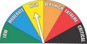
Burning of any kind is restricted unless approval is received from local Fire Chief. Controlled burns that are not reported will result in Fire Department being dispatched, and Fires extinguished if determined to be un-safe. Please call 712-755-2124 if you have any questions.
Today: Partly Cloudy. High 65. NE @ 10.
Tonight: P/Cldy. Low 45. SE @ 5-10.
Tomorrow: P/Cldy to Cldy w/scattered afternoon showers & thunderstorms. High 63. SE @ 10-20.
Wednesday: Showers ending in the morning; Becoming P/Cldy. High 65.
Thursday: P/Cldy. High 70.
Sunday’s High in Atlantic was 73. Our 24-hour Low (ending at 7-a.m. today) was 35. Last year on this date, our High in Atlantic was 61 and the low was 29. The Record High in Atlantic on this date was 82 in 1891. The Record Low was 15 in 1999.


