
Today: Mostly cloudy w/a 60% chance of rain, snow, and sleet before 1pm, then a slight chance of rain. High near 43. Winds N @ 15-30 mph. New snow and sleet accumulation of less than a half inch possible.
Tonight: Mostly cloudy, then gradually becoming mostly clear & breezy. Low around 22. N @ 10-20.
Tomorrow: Sunny, with a high near 48. N/NW @ 10-20 mph.
Tom. Night: Clear, with a low around 22.
Sunday: Sunny, with a high near 59.
Sunday Night: Clear & breezy, with a low around 36.
Monday: Sunny & breezy, with a high near 71.
Thursday’s High in Atlantic was 58.Our Low was 30. (Rainfall from Thursday afternoon thru 7-a.m. today, was .48,” with some freezing rain. Last year on this date, the High in Atlantic was 39 and the Low was 33. The Record High for March 8th in Atlantic, was 76 in 1986. The Record Low was -12 in 1982. Sunrise: 6:44. Sunset: 6:18-p.m.
Today: Mostly cloudy w/a 60% chance of rain, mainly after 5pm. High near 54. East winds 5-to 15 mph. New precipitation amounts of less than a tenth of an inch possible.
Tonight: Rain; Breezy. Low around 36. N/NE @ 10-20 mph w/gusts to near 30. New precipitation amounts between a one-tenth & one-quarter of an inch is possible.
Friday: Rain & snow likely before noon. Cloudy. High 43. N @ 20-30 mph. Little or no snow accumulation expected.
Saturday: Sunny & breezy with a high near 48. N/NW @ 10-20.
Sunday: Sunny, with a high near 59.
Wednesday’s High in Atlantic was 60.Our Low was 17. Last year on this date, the High in Atlantic was 47 and the Low was 33. The Record High for March 7th in Atlantic, was 78 in 2000. The Record Low was -11 in 1982.
Today: Partly sunny, with a high near 58. South southeast wind 5 to 10 mph.
Tonight: Mostly cloudy w/a 20% chance of showers after midnight. Low 37.
Tomorrow: Mo. Cldy w/a 60% chance of showers, mainly after noon. High near 55. East wind 5 to 15 mph. New precipitation amounts between a tenth and quarter of an inch possible.
Tom. Night: Showers & breezy. Low around 35. N/NE @ 10-20 mph w/gusts to around 30. New precipitation amounts between a quarter and half of an inch possible.
Friday: Showers likely, mainly before noon. Windy. High near 44. New precipitation amounts between a tenth and quarter of an inch possible.
Saturday: Sunny & breezy, with a high near 48.
Tuesday’s High in Atlantic was 59.Our Low this morning was 16. Last year on this date, the High in Atlantic was 41 and the Low was 32. The Record High for March 6th was 76 in 2017. The Record Low was -20 in 1960. Sunrise: 6:47. Sunset: 6:16-p.m.
Today: Mostly sunny. High near 56. North northeast wind 5 to 10 mph becoming northwest this afternoon.
Tonight: Partly cloudy. Low around 28.
Tomorrow: Partly sunny. High near 58. Southeast wind 5 to 15 mph.
Thursday: Mostly cloudy w/a 60% chance of rain, mainly after noon. High near 55.
Friday: Mostly cloudy & windy w/a 50% chance of rain. High near 48.
Monday’s High in Atlantic was 47. The 24-hour Low was 23. We received a trace of rain during the afternoon. Last year on this date, the High in Atlantic was 59 and the Low was 30. The Record High for March 5th was 74 in 1921. The Record Low was -31 in 1960. Sunrise: 6:49. Sunset: 6:15-p.m.
(Radio Iowa) – Local officials in about a third of Iowa counties have issued outdoor burning bans. National Weather Service meteorologist Rod Donovan says over the past week and a half the satellite data for Iowa shown lots of hot spots and radar has picked up smoke plumes from a lot of field fires.
“We actually had a pretty big fire just west of Colfax going across some grassland yesterday,” Donovan says.
It doesn’t take much to spark a fire in current conditions according to Donovan. “Part of the issue we’ve had across Iowa is really our abnormally short winter, at least abnormally dry and warm across the area,” Donovan says, “…not having a prolonged period of snow cover, a lack of precipitation.”
These conditions have extended the drought. Donovan says pastures, cropland and grassy areas enrolled in the Conservation Reserve Program are “extremely combustible” right now.
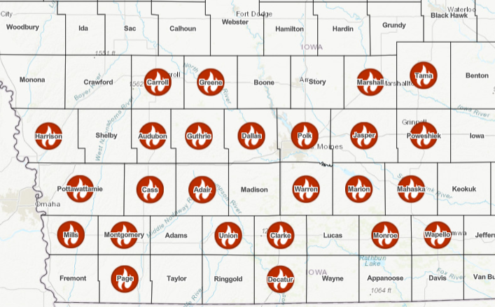
Counties in western/southwest Iowa with a Burn Place in effect (as of March 3, 2024)
“It doesn’t take much for an ignition source to create hazardous fire weather conditions,” Donovan says, “warm, very dry, low humidities in addition to these very strong springtime winds that we get across the state.”
The forecast for Iowa indicates March temperatures are likely to be above normal. Donovan says to expect more red flag warnings from the National Weather Service until plants spring to life and fields start turning green.
Today: Mostly cloudy & breezy w/a 30% chance of rain and thunderstorms. High near 55. NE winds 15-25 mph. New precipitation amounts of less than a tenth of an inch, except higher amounts possible in thunderstorms.
Tonight: Partly cloudy. Low around 30. N/NE winds @ 10-25 mph.
Tuesday: Mostly sunny, with a high near 57. Northeast wind 5 to 10 mph.
Wednesday: Partly sunny, with a high near 57.
Thursday: A 50% chance of rain. High near 57.
Sunday’s High in Atlantic was 74. The Low was 33. We received .02″ rain this morning (as of 6-a.m.). Last year on this date, the High in Atlantic was 51 and the Low was 25. The Record High for March 4th was 78 in 1921. The Record Low was -17 in 1978. Sunrise: 6:50. Sunset: 6:14-p.m.
Today: **RED FLAG WARNING from 9-a.m. until 6-p.m. for extreme fire danger**Sunny & windy. High near 73. S/SW wind becoming Westerly at 20-to near 40-mph.
Tonight: Partly cloudy & breezy. Low around 41. W-E/NE @ 10-20.
Monday: Partly sunny w/a 30% chance of rain, mainly before noon. High near 60. North wind 10 to 15 mph. New precipitation amounts of less than a tenth of an inch possible.
Tuesday: Mostly sunny. High near 61. NE-N/NW @ 5-10.
Wednesday: Partly sunny w/a slight chance of rain. High near 59.
Saturday’s High in Atlantic was 69. The Low was 35. Last year on this date, the High in Atlantic was 54 and the Low was 26. The Record High for March 3rd was 79 in 1983. The Record Low was -11 in 2014. Sunrise: 6:53. Sunset: 6:12-p.m.
Friday’s High in Atlantic was 57. The Low was 35. Last year on this date, the High in Atlantic was 43 and the Low was 25. The Record High for March 2nd was 76 in 1992. The Record Low was -12 in 2014. Sunrise: 6:53. Sunset: 6:11-p.m.
(Radio Iowa/KJAN) – The calendar says spring doesn’t arrive until March 19th, but meteorological winter actually ended yesterday (Thursday), making today (Friday) the first day of meteorological spring. State climatologist Justin Glisan says it was cold and snowy, sure, but it really wasn’t much of a winter. “For December-January-February, third warmest winter on record,” Glisan says, “almost seven degrees above average. We’ve been throwing around the phrase ‘the lost winter,’ given how warm conditions were.”
As for the just-ended month of February, Glisan says what little snow fell didn’t stick around long. “If we’re looking at the average temperature, it was about 36 degrees,” Glisan says, “second warmest February in 152 years of records. That average is actually the climatological average temperature for March.” The statewide average for precipitation during February was only two-tenths of an inch, making it Iowa’s third-driest February on record. Glisan says forecast models predict March will be warmer than normal, with good chances for increased precipitation.
Weather data for February in Atlantic, shows we were much warmer and drier than average, last month. The Average High was 53, and the average Low was 21. Typically, we would have had a High of 35 and a Low of 15. Precipitation (melted snowfall) amounted to just one-tenth (.10″) of an inch, which was considerably less than the .96″ we would normally expect. Snowfall for the month was just one-inch.The data was compiled at KJAN, the official National Weather Serving reporting site for Atlantic.
Looking ahead, we find the Average High for the month of March, in Atlantic, is typically 48 degrees, while the Low should average out to be around 26. Precipitation (rain & or melted snow) is typically just under an inch, at 2.38 inches.


