
352 PM CST SUN DEC 25 2016
Pottawattamie IA-Harrison IA-Fremont IA-Mills IA
…SIGNIFICANT WEATHER ADVISORY FOR WESTERN FREMONT…SOUTHWESTERN HARRISON…WESTERN MILLS…WESTERN POTTAWATTAMIE…UNTIL 415 PM CST…
At 351 PM CST, Doppler radar was tracking strong thunderstorms along a line extending from near Arlington (NE) to 3 miles southwest of Lorton (NE). Movement was northeast at 50 mph. Wind gusts up to 50 mph will be possible with these storms. Winds gusted to between 45 and 50 mph when the line moved past the National Weather Service in Valley.
Locations impacted include…Omaha, Council Bluffs, Bellevue, Papillion, La Vista, Blair, Nebraska City, Plattsmouth, Ralston, Glenwood, Gretna, Missouri Valley, Valley, Springfield, Arlington, Sidney, Louisville, Weeping Water, Fort Calhoun and Waterloo.
This includes the following highways…
HIGHWAY 275 IN NEBRASKA near MILE MARKER 167.
HIGHWAY 30 IN IOWA between MILE MARKERs 1 and 5.
HIGHWAY 30 IN NEBRASKA between MILE MARKERs 435 and 450.
HIGHWAY 2 IN NEBRASKA between MILE MARKERs 490 and 508.
HIGHWAY 34 IN IOWA between MILE MARKERs 1 and 9.
HIGHWAY 75 IN NEBRASKA between MILE MARKERs 45 and 120.
HIGHWAY 92 IN NEBRASKA between MILE MARKERs 463 and 466.
INTERSTATE 29 between MILE MARKERs 7 and 86.
INTERSTATE 80 IN IOWA between MILE MARKERs 1 and 8.
INTERSTATE 80 IN NEBRASKA between MILE MARKERs 430 and 454.
MONONA-HARRISON-SHELBY-POTTAWATTAMIE-MILLS-MONTGOMERY-FREMONT-PAGE-COUNTIES:
…DENSE FOG ADVISORY IS CANCELLED…
THE NATIONAL WEATHER SERVICE IN OMAHA/VALLEY HAS CANCELLED THE DENSE FOG ADVISORY. VISIBILITIES HAVE IMPROVED AND SHOULD REMAIN MOSTLY ABOVE 1/2 MILE THIS MORNING.
THERE ARE CURRENTLY NO WEATHER ADVISORIES IN EFFECT IN THE KJAN LISTENING AREA.
Today (Christmas Day): Areas of fog this morning; Showers & possibly a thunderstorm. High near 55. East/southeast wind at 15-25mph w/gusts to around 35 this afternoon. New rainfall amounts between a half and three quarters of an inch possible.
Tonight: Showers & possibly a thunderstorm before 9pm, then a slight chance of rain between 9pm and 10pm. Low around 28. S winds @ 15-25mph becoming w/sw after midnight and gusting up to 35. New precipitation amounts between a tenth and quarter of an inch, except higher amounts possible in thunderstorms.
Monday: Sunny & windy, with a nearly steady temperature around 31. W @ 15-35mph.
Monday Night: Mostly clear, with a low around 21. W @ 10-20mph.
Tuesday: Sunny, with a high near 42.
Wednesday: Mostly sunny, with a high near 43.
Saturday’s High in Atlantic was 40. Our 24-Hour Low (ending at 7-a.m. today) was 23. We received .01” rain overnight. Last year on this date, our High in Atlantic was 33 and the low was 22. The Record High in Atlantic on this date was 56 in 1922. The Record Low was -20 in 1983.
A Dense Fog Advisory remains in effect until 9-a.m. today (Sunday), for Monona-Harrison-Shelby-Pottawattamie-Mills-Montgomery-Fremont and Page Counties in the KJAN listening area.
Expect visibility in the Advisory area of less than one-half mile at times this morning.
Reduced visibilities will cause some difficult driving conditions. Also, with some temperatures at or just below freezing in some locations, a light glazing on the roads and sidewalks could lead to slippery conditions. Caution is advised when driving or walking.
If driving, slow down, use your low beam headlights, and leave plenty of distance ahead of you.
The National Weather Service has issued Dense Fog Advisories for all counties in western, southwest, west central and northwest Iowa. In Cass-Adair-Adams-Audubon-Carroll-Crawford-Dallas-Guthrie-Madison-Union-Taylor and Ringgold Counties, a DENSE FOG ADVISORY is in effect until 4-a.m. Sunday. In Monona-Harrison-Shelby-Pottawattamie-Mills-Montgomery-Fremont and Page Counties, a DENSE FOG ADVISORY is in effect until 9-a.m., Sunday.
* VISIBILITY…IS EXPECTED TO DROP TO A QUARTER MILE OR LESS
DURING THE EVENING AND CONTINUE OVERNIGHT. AREAS ALONG AND EAST OF THE MISSOURI RIVER SHOULD SEE THE DENSE FOG FIRST, WITH AN EXPANSION TO THE WEST AND SOUTH THROUGH THE EVENING.
* IMPACTS…REDUCED VISIBILITIES WILL CAUSE SOME DIFFICULT DRIVING
CONDITIONS. ALSO, WITH SOME TEMPERATURES NEAR OR JUST BELOW
FREEZING, LIGHT GLAZING ON ROADS AND SIDEWALKS COULD LEAD TO
SLIPPERY CONDITIONS. CAUTION IS ADVISED WHILE DRIVING OR
WALKING.
PRECAUTIONARY/PREPAREDNESS ACTIONS…
A DENSE FOG ADVISORY MEANS VISIBILITIES WILL FREQUENTLY BE REDUCED TO LESS THAN ONE QUARTER MILE. IF DRIVING, SLOW DOWN, USE
YOUR HEADLIGHTS, AND LEAVE PLENTY OF DISTANCE AHEAD OF YOU.
852 AM CST SAT DEC 24 2016…A DENSE FOG ADVISORY IS NOW IN EFFECT UNTIL 1 PM CST THIS AFTERNOON FOR WESTERN AND SOUTHWEST IOWA.
* VISIBILITY…DENSE FOG WILL DROP THE VISIBILITY TO ONE QUARTER
MILE TO ZERO AT TIMES THIS MORNING.
* IMPACTS…WIDESPREAD FROST FORMATION IS BEING REPORTED OVER
NORTH CENTRAL IOWA AS A DIRECT IMPACT OF THIS FOG. THE FROST
WILL CREATE ICY CONDITIONS ACROSS THE AREA. VISIBILITY NEAR
ZERO AT TIMES WILL LENGTHEN TRAVEL TIMES.
PRECAUTIONARY/PREPAREDNESS ACTIONS…
A DENSE FOG ADVISORY MEANS VISIBILITIES WILL FREQUENTLY BE
REDUCED TO LESS THAN ONE QUARTER MILE. IF DRIVING, SLOW DOWN, USE
YOUR LOW BEAM HEADLIGHTS, AND LEAVE PLENTY OF DISTANCE AHEAD OF
YOU. BE ESPECIALLY CAUTIOUS NEAR INTERSECTIONS AND RAILROAD
CROSSINGS.
Today: **Dense Fog Advisory until 9-a.m.**
Dense Fog this morning, otherwise Cloudy. High 39. S @ 5-10.
Tonight: Cloudy. Low 30. NW @ 10.
Christmas Day: Cloudy w/a 90% chance of showers. High 51. SE @ 15-30.
Sunday Night: Showers ending; Becoming P/Cldy. Low around 29.
Monday: Mostly Sunny & colder. High 34.
Tuesday: Mo. Sunny. High 35.
Wednesday: P/Cldy. High 43.
Friday’s High in Atlantic was 37. Our 24-Hour Low (ending at 7-a.m. today) was 21. We received .2” of snow yesterday, and rain, the combined liquid value of which amounted to .19”. Last year on this date, our High in Atlantic was 29 and the low was 14. The Record High in Atlantic on this date was 55 in 1893 & 1964. The Record Low was -23 in 1983.
…DENSE FOG ADVISORY IN EFFECT UNTIL 9 AM CST THIS MORNING…
EARLY THIS MORNING…MOSTLY CLEAR. WIDESPREAD DENSE FOG. WEST WIND NEAR 5 MPH.
TODAY…WIDESPREAD DENSE FOG IN THE MORNING, OTHERWISE PARTLY SUNNY WITH AREAS OF FOG EARLY IN THE AFTERNOON. HIGH IN THE UPPER 30S. SOUTHEAST WIND NEAR 10 MPH.
TONIGHT…MOSTLY CLOUDY. WIDESPREAD FOG THROUGH THE NIGHT. A CHANCE OF DRIZZLE AFTER MIDNIGHT. A CHANCE OF DRIZZLE AND A SLIGHT CHANCE OF THUNDERSTORMS EARLY IN THE MORNING. LOW IN THE LOWER 30S. EAST WIND 5 TO 15 MPH. GUSTS UP TO 25 MPH AFTER MIDNIGHT.
CHRISTMAS DAY…RAIN SHOWERS AND A CHANCE OF THUNDERSTORMS. WIDESPREAD FOG. WINDY, WARMER. HIGH IN THE MID 50S. SOUTHEAST WIND 15 TO 20 MPH WITH GUSTS TO AROUND 30 MPH INCREASING TO 20 TO 30 MPH WITH GUSTS TO AROUND 40 MPH IN THE AFTERNOON. CHANCE OF PRECIPITATION NEAR 100 PERCENT.
SUNDAY NIGHT…PARTLY CLOUDY. A 40 PERCENT CHANCE OF LIGHT RAIN SHOWERS THROUGH MIDNIGHT. BREEZY. LOW IN THE UPPER 20S. SOUTHWEST WIND 15 TO 25 MPH WITH GUSTS TO AROUND 35 MPH.
MONDAY…SUNNY, BREEZY, COLDER. HIGH IN THE MID 30S. WEST WIND 15 TO 20 MPH WITH GUSTS TO AROUND 30 MPH.
TUESDAY…SUNNY. HIGH IN THE UPPER 30S.
THE NATIONAL WEATHER SERVICE SAYS A DENSE FOG ADVISORY IS IN EFFECT UNTIL 9 AM TODAY (SATURDAY) FOR ALL OF WESTERN AND SOUTHWEST IOWA, PARTS OF NORTHWEST AND NORTH CENTRAL IOWA.
* VISIBILITY…DENSE FOG WILL DROP VISIBILITIES TO ONE QUARTER MILE OR LESS AT TIMES THIS MORNING.
* IMPACTS…IN ADDITION TO VISIBILITY RESTRICTIONS THIS MORNING…THE FOG MAY CREATE A LIGHT MIST OR RESULT IN FROST ON ROADWAYS AND CAUSE ICY PATCHES ESPECIALLY ON OVERPASSES AND BRIDGES.
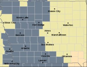
Dense Fog Advisory for Counties in gray.
PRECAUTIONARY/PREPAREDNESS ACTIONS…
A DENSE FOG ADVISORY MEANS VISIBILITIES WILL FREQUENTLY BE REDUCED TO LESS THAN ONE QUARTER MILE. IF DRIVING, SLOW DOWN, USE YOUR HEADLIGHTS, AND LEAVE PLENTY OF DISTANCE AHEAD OF YOU.
147 PM CST FRI DEC 23 2016
SNOW WILL END FROM WEST TO EAST THIS AFTERNOON….SNOW IS BEGINNING TO DIMINISH AND WILL END DURING THE AFTERNOON…WITH LIGHT ADDITIONAL ACCUMULATIONS BEFORE SUNSET.
THE WINTER WEATHER ADVISORY IS CANCELLED. SOME ROADS MAY REMAIN SLICK HOWEVER.


