
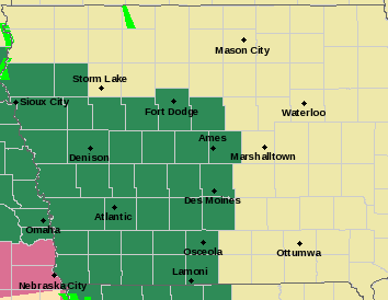
A FLASH FLOOD WATCH remains in effect until 7-a.m. Saturday for the following counties in Western Iowa: Sac-Crawford-Carroll-Greene-Audubon-Guthrie-Dallas-Cass-Adair-Madison-Adams-Union-Taylor-Ringgold.
A FLOOD WATCH remains in effect until 5-a.m. Saturday for these counties: Harrison-Shelby-Pottawattamie-Mills-Montgomery-Fremont-Page.
 FLOOD WATCH details: Occasional rounds of showers and thunderstorms with heavy rain potential are expected through tonight. Additional amounts of 1 to 3 inches are possible, which would put storm total rains from Thursday through tonight in the 2 to 6 inch range. Flooding of low-lying area, urban areas and eventually rivers and streams could result.
* In addition to the general flood threat, faster or flash flooding, could occur with some storms that may develop through this evening in southeast Nebraska and southwest Iowa.
FLASH FLOOD WATCH details: Widespread rainfall amounts of 1 to 3 inches of rain can be expected through Saturday morning, with locally higher amounts in excess of 3 inches likely. Rainfall rates will be heavy at times with the potential for rainfall amounts of 2 inches occurring in an hour or less.
* Heavy rainfall may lead to rapid rises on local creeks and streams which may be high enough to cross roadways, especially low lying areas. Significant ponding of water on roadways is expected at times as well. Flash flooding at night is extremely dangerous and drivers should turn around if they come to an area where water is flowing over the road.
PRECAUTIONARY/PREPAREDNESS ACTIONS…
A Flash Flood Watch means that conditions may develop that lead to flash flooding. Flash flooding is a VERY DANGEROUS SITUATION. You should monitor later forecasts and be prepared to take action should Flash Flood Warnings be issued.
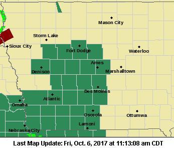
THE NATIONAL WEATHER SERVICE HAS EXTENDED A FLASH FLOOD WATCH TO COUNTIES NORTH OF INTERSTATE 80 THRU 7-A.M. SATURDAY. The FLASH FLOOD WATCH now includes the Counties of Audubon, Guthrie, Dallas, Sac, Crawford and Carroll in the KJAN listening area. That’s in addition to the previouslyt mentioned counties of Cass, Adair, Adams, Madison, Ringgold, Taylor and Union.
* Widespread rainfall amounts of 1 to 3 inches of rain can be expected through Saturday morning, with locally higher amounts in excess of 3 inches possible.
* Heavy rainfall may lead to rapid rises on local creeks and streams and ponding of water on roadways.
 PRECAUTIONARY/PREPAREDNESS ACTIONS…
A Flash Flood Watch means that conditions may develop that lead to flash flooding. Flash flooding is a VERY DANGEROUS SITUATION. You should monitor later forecasts and be prepared to take action should Flash Flood Warnings be issued.
Remember also, A FLOOD WATCH continues until 5-a.m. Saturday for Pottawattamie-Mills-Montgomery-Fremont-Page Counties. Occasional rounds of showers and thunderstorms with heavy rainfall potential are expected through tonight. Additional rainfall of 1 to 3 inches are possible, which would put storm total rains from Thursday through tonight in the 2.5 to 5 inch range. Flooding of low-lying area, urban areas and eventually rivers and streams could result.
If you’re heading outside today, tonight, or tomorrow morning, you’ll need your umbrella. The National Weather Service in Des Moines says Light showers continued overnight across much of Iowa, and will continue into the day today. A few strong to possibly severe thunderstorms are possible late this afternoon across southwestern to southern Iowa. Rainfall amounts tonight should be a widespread 1 to 1.5 inches. Another 0.1 to 0.25 inches of rain may fall from the 7 am to noon Saturday time period. In all 2 to 3 inches of rain is expected from Atlantic to Denison to Fort Dodge to Mason City.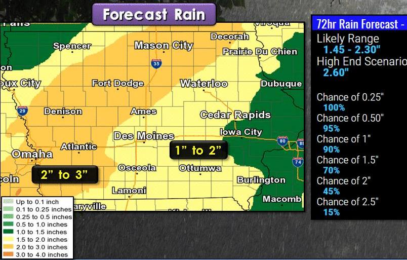
The National Weather Service in Des Moines has issued a Flash Flood Watch for portions of south central Iowa and southwest Iowa. Area Counties included in the Watch are: Adair, Adams, Cass, Madison, Ringgold, Taylor and Union.
* The Flash Flood Watch is in effect from 7 AM CDT today (Friday) through 7-a.m. Saturday
* Widespread rainfall amounts of 1 to 3 inches of rain can be expected through Saturday morning, with locally higher amounts in excess of 3 inches possible.
* Heavy rainfall may lead to rapid rises on local creeks and streams and ponding of water on roadways.
PRECAUTIONARY/PREPAREDNESS ACTIONS…
A Flash Flood Watch means that conditions may develop that lead to flash flooding. Flash flooding is a VERY DANGEROUS SITUATION. You should monitor later forecasts and be prepared to take action should Flash Flood Warnings be issued.
In addition, A FLOOD WATCH continues until 5-a.m. Saturday for Pottawattamie-Mills-Montgomery-Fremont-Page Counties. Occasional rounds of showers and thunderstorms with heavy rainfall potential are expected through tonight. Additional rainfall of 1 to 3 inches are possible, which would put storm total rains from Thursday through tonight in the 2.5 to 5 inch range. Flooding of low-lying area, urban areas and eventually rivers and streams could result.
Skyscan Forecast – Dan Hicks – Thursday, 10/06/17
Today: FLASH FLOOD WATCH from 7-a.m. today until 7-a.m. Saturday, for: Cass, Adair, Adams, Madison, Ringgold, Taylor & Union Counties; FLOOD Watch continues until 5-a.m. Saturday for Pottawattamie-Mills-Montgomery-Fremont and Page Counties.
Mostly cloudy w/areas of fog & drizzle this morning; Heavy rain & thunderstorms are likely this afternoon. High 72. E/SE @ 10-15.
Tonight: Shwrs & tstrms. Low 58. S @ 10-15.
Tomorrow: Shwrs & tstrms ending. Mo.Cldy & windy. High 66. NW @ 10-15.
Sunday: P/Cldy. High 78.
Monday: Mo. Cloudy w/scattered shwrs. High around 67.
Thursday’s High in Atlantic was 66. Our Low was 57. We received .71 rain from 7-a.m. Thursday through 5-a.m. today. Last year on this date, the High in Atlantic was 66 and the low was 38. The Record High in Atlantic on this date was 91 in 1963 & 2005. The Record Low for this date was 15 in 2012.
Pottawattamie-Saunders-Douglas-Sarpy-
Including the cities of Council Bluffs, Wahoo, Ashland, Yutan,
Omaha, Bellevue, Papillion, and La Vista
…FLOOD WATCH IN EFFECT THROUGH LATE FRIDAY NIGHT…
The National Weather Service in Omaha/Valley has expanded the
* Flood Watch to include portions of southwest Iowa and east
central Nebraska, including the following areas, in southwest
Iowa, Pottawattamie. In east central Nebraska, Douglas, Sarpy,
and Saunders.
* Through late Friday night
* Several additional rounds of showers and thunderstorms with
heavy rainfall potential are expected tonight through Friday
night. Storm total rainfall of 2 to 3.5 inches could occur,
which may result in minor flooding of low lying areas and some
urban flooding.
PRECAUTIONARY/PREPAREDNESS ACTIONS…
A Flood Watch means there is a potential for flooding based on
current forecasts.
You should monitor later forecasts and be alert for possible
Flood Warnings. Those living in areas prone to flooding should be
prepared to take action should flooding develop.
Today: Cloudy w/light rain mid-day thru early afternoon, then a 60% chance of showers and thunderstorms. High near 68. SE @ 10-20New rainfall amounts between a tenth and quarter of an inch, except higher amounts possible in thunderstorms.
Tonight: Showers and possibly a thunderstorm. Low around 60. SE @ 5-10. New rainfall amounts between a quarter and half of an inch possible.
Friday: Showers and possibly a thunderstorm. High near 72.SE @ 10-20. New rainfall amounts between a half and three quarters of an inch possible.
Friday Night: Showers and possibly a thunderstorm. Some of the storms could produce heavy rainfall. Low around 53. New rainfall amounts between 1 and 2 inches possible.
Saturday: A 40% chance of showers and thunderstorms thru mid-day. High near 68. W/SW @ 10-20. New precipitation amounts of less than a tenth of an inch, except higher amounts possible in thunderstorms.
Sunday: P/Cldy. High near 76.
Wednesday’s High in Atlantic was 70. Our Low this morning 50. Last year on this date, the High in Atlantic was 73 and the Low was 51. The All-time Record High for this date in Atlantic was 93 in 1963, and the All-time Record Low was 22 in 2012.
A FLOOD WATCH REMAINS IN EFFECT FROM 1 PM TODAY (THURSDAY) THROUGH THROUGH 5-A.M. SATURDAY, FOR Fremont, Mills, Montgomery, and Page Counties…
Numerous rounds of showers and thunderstorms with heavy rainfall potential are expected later today into Friday. This could eventually could create locally 3 to 6 inches of rain over a prolonged period of time, which may result in flooding of low lying areas, and possibly some rivers and streams.
PRECAUTIONARY/PREPAREDNESS ACTIONS…
A Flood Watch means there is a potential for flooding based on current forecasts. You should monitor later forecasts and be alert for possible Flood Warnings. Those living in areas prone to flooding should be prepared to take action should flooding develop.
The National Weather Service in Omaha/Valley has issued a Flood Watch for portions of southwest Iowa and southeast Nebraska, including the following Counties, in southwest Iowa: Fremont, Mills, Montgomery, and Page, from 1-p.m. Thursday through 5-a.m. Saturday.
* Numerous rounds of showers and thunderstorms with heavy rainfall potential are expected Thursday into Friday. This could eventually could create 2 to 4 inches of rain over a prolonged period of time, which may result in flooding of low lying areas,
and possibly some rivers and streams. Rainfall over the previous 48 hours has averaged three quarters to two and a half inches in some areas, thus the soil may already be wet in some locations.
PRECAUTIONARY/PREPAREDNESS ACTIONS…
A Flood Watch means there is a potential for flooding based on current forecasts.
You should monitor later forecasts and be alert for possible Flood Warnings. Those living in areas prone to flooding should be prepared to take action should flooding develop.


