
The National Weather Service has issued a Winter Weather Advisory from tonight through early Sunday morning for those counties along and south of I-80 in the KJAN listening area. The Advisory is in effect from 6-p.m. today through 9-a.m. Sunday, for Cass-Adair-Madison-Adams-Union-Taylor-and Ringgold Counties, and from 6-p.m. today through 6-a.m. Sunday for Pottawattamie-Mills-Montgomery-Fremont and Page Counties.
* WHAT…Snow expected. Plan on slippery and/or snow covered road conditions. Total snow accumulations of 1 to 3 inches are expected with isolated 4 inch totals closer to the Missouri border.
* ADDITIONAL DETAILS…Be prepared for slick, snow covered roads and reduced visibilities at times due to falling snow.
PRECAUTIONARY/PREPAREDNESS ACTIONS…
A Winter Weather Advisory for snow means periods of snow will cause primarily travel difficulties. Be prepared for snow covered roads and limited visibilities, and use caution while driving. The latest road conditions for the state you are calling from can be obtained by calling 5 1 1 or going to 511ia.org.
340 AM CST Sat Dec 23 2017

...Snow spreading into parts of eastern Nebraska and southwest
Iowa tonight...

An upper level disturbance is expected to produce a band of
accumulating snow over parts of eastern Nebraska and southwest
Iowa starting this evening and lasting into Sunday morning. The
highest snow amounts, from 2 to 4 inches, are currently expected
mainly south of a line from around Columbus to Blair and Logan
Iowa.

Pottawattamie-Mills-Montgomery-Fremont-Page Counties...

...WINTER WEATHER ADVISORY IN EFFECT FROM 6 PM THIS EVENING TO
6 AM CST SUNDAY...

The National Weather Service in Omaha/Valley has issued a Winter
Weather Advisory for snow, which is in effect from 6 PM this
evening to 6 AM CST Sunday.

* TIMING...Snow should spread east across the area this evening
  and then decrease by around sunrise Sunday.

* MAIN IMPACT...Accumulating snow could cause slippery roads and
  areas of reduced visibility.

* OTHER IMPACTS...winds with this event are expected to be mainly
  under 15 mph, which will limit blowing and drifting.

PRECAUTIONARY/PREPAREDNESS ACTIONS...

A Winter Weather Advisory for snow means that periods of snow
will cause primarily travel difficulties. Be prepared for snow
covered roads and limited visibilities, and use caution while
driving.
Today: Mostly cloudy w/flurries this morning; P/Cldy this afternoon. High 30. NW @ 10-20.
Tonight: P/Cldy. Low 12. Light & variable breeze.
Tomorrow: P/Cldy. High 26. NW @ 10.
Sunday: Mo. Cldy w/morning flurries. High 23.
Monday: Mo. Cldy. High around 25. (Christmas Day)
We received .3” snow yesterday, and about .1′ ice. The precipitation melted down to a equivalent of one-tenth of an inch of rain. Our high early in the day was 39. The this morning 22. Last year on this date our High was 43 and the Low was 15. The all-time record High in Atlantic on this date was 65 in 1933, and the Low was -27 in 1989.
…Freezing Drizzle To Impact Evening Commute… .
Areas of freezing drizzle will persist over portions of west central to central Iowa into the evening hours. While the precipitation has mainly transitioned over to snow along and north of Highway 20, areas further south along the Highway 30 and Interstate 80 corridors are seeing a wintry mix of freezing drizzle and ice pellets. Some light ice glaze has been reported, mainly on elevated surfaces and untreated roads across portions of central and west central Iowa. An additional light glaze is likely through the evening hours, especially during the evening rush hour. Further north, snowfall amounts of 1 to 2 inches are possible by tonight.
The Winter Weather previously issued for several area counties has been expanded to include Guthrie-Dallas-Cass-and Adair Counties, and remains in effect until 9-p.m.
A mix of freezing drizzle and ice pellets is occurring and will persist into the evening evening hours. This will include the evening commute. Ice accumulations of up to one tenth of an inch will be possible.
Today (Thursday) is the first official day of winter and it’s beginning to feel like it across Iowa. National Weather Service Meteorologist Brad Fillbach says much of Iowa’s mid-section could receive light freezing rain, while far northern Iowa should see snow. “As far as tonight and tomorrow morning, you’re looking at more freezing precipitation into this evening. Tomorrow looks to be dry with temperatures getting colder,” Fillbach said.
Some slick roads are possible, especially on overpasses and bridges. The snow over northern Iowa likely won’t amount to much. “The snowfall amounts should be on the light side, an inch or less,” Fillbach said. “The heavier stuff will stay up north of Iowa.” Sections of southern Minnesota could get up to three inches of snow today. People traveling through Iowa this weekend could face another hazard. “Weather-wise, the biggest concern for Christmas travel is going to be the temperatures,” Fillbach said. “Temperatures are going to be considerably cooler, with lows in the single digits.”
High temperatures in Iowa Saturday and Sunday will be in the 20s to low 30s. The forecast for Christmas day (Monday) includes a chance of light snow with morning lows near zero in northern Iowa to the mid-teens south. Afternoon highs should range from 10 to 30 degrees.
(Radio Iowa)
Today: Cloudy w/light drizzle becoming mixed precipitation and later, light snow. High early around 40, with the temp dropping to the upper 20’s by sunset. E-N @ 10-20.
Tonight: Mostly Cloudy w/light snow ending. Low 20. NW @ 15-30. Up to 1” of snow is possible.
Tomorrow: P/Cldy to Cldy. High around 30. NW @ 10-20.
Saturday: P/Cldy. High 25.
Sunday: P/Cldy to Cldy w/morning flurries. High around 23.
Wednesday’s High in Atlantic was 47. Our 24-hour was 16.Last year on this date, the High in Atlantic was 49 and the low was 17. The Record High in Atlantic on this date was 58 in 1941. The Record Low for this date was -22 in 1989.
The National Weather Service has issued Winter Weather Advisories for parts of western and southwest Iowa. The Advisory is in effect from 6-a.m. today until 9-p.m. for Carroll, Crawford, Audubon, Harrison, Monona and Shelby Counties, and from Noon today until 9-p.m., for Pottawattamie, Mills, and Fremont Counties.
Expect freezing drizzle and mixed precipitation which will result in difficult travel conditions, including during the evening commute. Total snow accumulations of up to one inch and ice accumulations of up to one tenth of an inch are expected. The ice will result in very slippery conditions on sidewalks, roads and bridges, including during the evening commute. Be prepared for reduced visibilities at times as well.
Slow down and use caution while driving. The latest road conditions can be obtained by calling 5-1-1 or surfing the web at 511ia.org.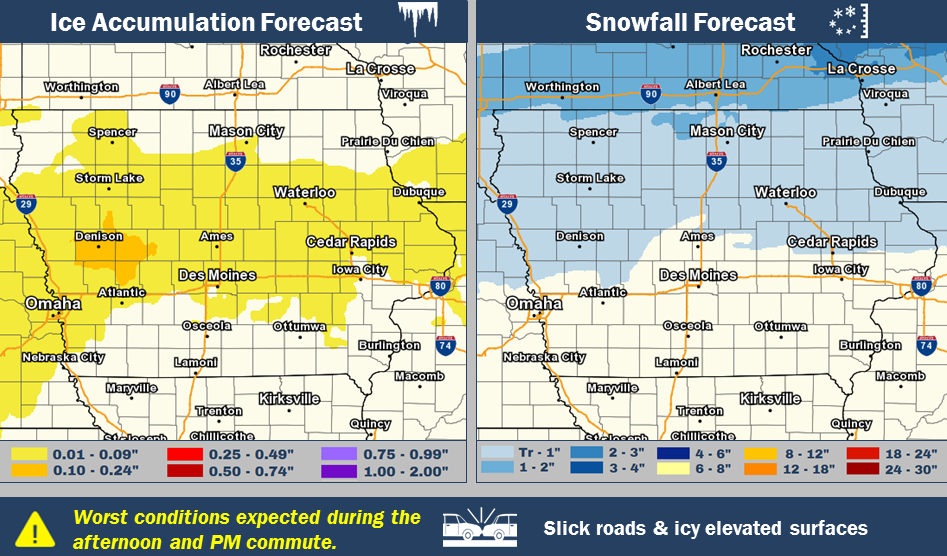
Today: Partly cloudy. High around 44. SE @ 10-15.
Tonight: Mostly Cloudy. Low 32. E @ 5-10.
Tomorrow: Cldy w/light rain switching over to light mixed precipitation before becoming light snow. High early of 37 w/temps dropping during the day. Less than 1” of snow is expected.
Friday: P/Cldy to Cloudy w/flurries. High 28.
Saturday: P/Cldy to Cldy. High around 23.
Tuesday’s High in Atlantic was 49. Our Low this morning was 16.Last year on this date, the High in Atlantic was 44 and the low was 20. The Record High in Atlantic on this date was 61 in 1941. The Record Low for this date was -25 in 1901.
Today: Partly cloudy. NW @ 10-15. High near 50.
Tonight: P/Cldy. Low 20.
Tomorrow: P/Cldy to Cldy. High 44. SE @ 10-15.
Thursday: Mostly Cloudy w/light rain & mixed precip. At times. High 42 early, with temps dropping during the day.
Friday: Mo. Cldy w/flurries. High near 25.
Monday’s High in Atlantic was 51. Our Low this morning (as of 5:20-a.m.) was 26.Last year on this date, the High in Atlantic was 25 and the low was 3. The Record High in Atlantic on this date was 58 in 1966. The Record Low for this date was -33 in 1983.
Winter may be making a very timely arrival later this week. The winter solstice will occur at 10:28 A-M Central Time on Thursday and forecasters say Iowa may see snow fly about that same time as much colder weather arrives, as if on cue. Meteorologist Cory Martin, at the National Weather Service, says they’re tracking a storm system that will be moving across the Northern Plains in the Thursday-Friday timeframe.
“It looks likely that parts of Iowa are going to see their first accumulating snowfall of the winter season,” Martin says. “That looks most likely across northern Iowa at this point. Further south, into central and southern Iowa, it’s a little bit more uncertain. We’re going to have some relatively warm air lingering around that might keep us with rain or a rain-snow mix.”
Since it’s still a few days away, forecasters are shying away from predicting just how much snow will fall and where, though Martin says it’s likely most of central and southern Iowa will see little-to-no accumulation. “Further north, how much snow we’re expecting right now, it doesn’t look like anything too heavy,” Martin says. “It looks like the best bet for heavier snow will probably stay up in South Dakota to Minnesota but we’ll continue to monitor that.”
With the Christmas holiday coming up, there will be plenty of motorists on the roads later this week. Martin says the state’s main east-west corridor may be wet but it shouldn’t be white. “Oh, for Interstate 80, I wouldn’t alter any travel plans at this point,” Martin says. “Just stay vigilant for forecast updates to see if anything changes through the week. One thing to keep in mind for the weekend, we are looking at a rather cold air mass surging south out of Canada. It’s going to be below- to well-below-normal temperatures here. If you’re traveling, make sure you have safety kits with you, just in case something were to happen.”
The latest forecast calls for rain likely most of Thursday before changing to freezing rain near sunset. A mix of freezing rain and snow is likely to continue Thursday night into early Friday morning. Another travel hazard on Thursday and Friday could be strong, gusty winds. Temperatures will be plummeting over the weekend as well.
(Radio Iowa)


