
(UPDATE) Area Counties: Adair-Adams-Audubon-Cass-Dallas-Fremont-Guthrie-Harrison-Madison-Mills-Montgomery-Pottawattamie-Shelby-Page and Union.
...DENSE FOG ADVISORY IN EFFECT UNTIL 9 AM CDT THIS MORNING…
The National Weather Service has issued a Dense Fog Advisory, which is in effect until 9 AM CDT this morning.
* VISIBILITY…Less than a quarter miles at times.
* IMPACTS…Restricted visibilities will result in difficult driving conditions, especially during the morning commute.
PRECAUTIONARY/PREPAREDNESS ACTIONS…
A Dense Fog Advisory means visibilities will frequently be reduced to less than one quarter mile. If driving, slow down, use your headlights, and leave plenty of distance ahead of you.
Today: Dense Fog Advisory until 9-a.m.; Otherwise Mostly sunny. High around 90. S @ 10-15.
Tonight: Fair to partly cloudy. Low 72.
Tomorrow: P/Cldy w/isolated showers & thunderstorms. High 88. S @ 10-15mph.
Monday: P/Cldy w/isolated showers & tstrms. High 88.
Tuesday: Mo. Cldy w/scattered shwrs & tstrms. High 84.
Yesterday’s High in Atlantic was 84. We received .01″ rain after 7-a.m. (the 24-hour cut-off time), Friday. Our Low this morning 60. Last year on this date our High was 78 and the Low was 62. The record High in Atlantic on this date was 108 in 1936. The Record Low was 34 in 1934.
Audubon-Cass-Adams-Taylor-Harrison-Shelby-Pottawattamie-Mills-Montgomery-Fremont-Page Counties…
...DENSE FOG ADVISORY IN EFFECT UNTIL 9 AM CDT THIS MORNING…
The National Weather Service has issued a Dense Fog Advisory, which is in effect until 9 AM CDT this morning.
* VISIBILITY…Less than a quarter miles at times.
* IMPACTS…Restricted visibilities will result in difficult driving conditions, especially during the morning commute.
PRECAUTIONARY/PREPAREDNESS ACTIONS…
A Dense Fog Advisory means visibilities will frequently be reduced to less than one quarter mile. If driving, slow down, use your headlights, and leave plenty of distance ahead of you.
Today: Mostly cloudy w/light rain/drizzle & fog this morning; P/Cldy this afternoon. High around 83. S-SW @ 10-20.
Tonight: P/Cldy w/areas of fog. Low 64.
Tomorrow: Areas of morning fog; Mo. Sunny. High near 90. S @ 10-20mph.
Sunday & Monday: P/Cldy w/isolated showers & tstrms. Highs near 90 both days.
Yesterday’s High in Atlantic was 73. Our Low this morning 55. As of 5-a.m., we had received just .02: rain. Last year on this date our High was 79 and the Low was 59. The record High in Atlantic on this date was 105 in 1936. The Record Low was 37 in 1908.
The National Weather Service in Des Moines says a few strong to severe storms are possible this afternoon and overnight across western into central Iowa. The main threats are large hail and damaging winds. Storms are expected to continue overnight, with the severe threat shifting east for Friday.
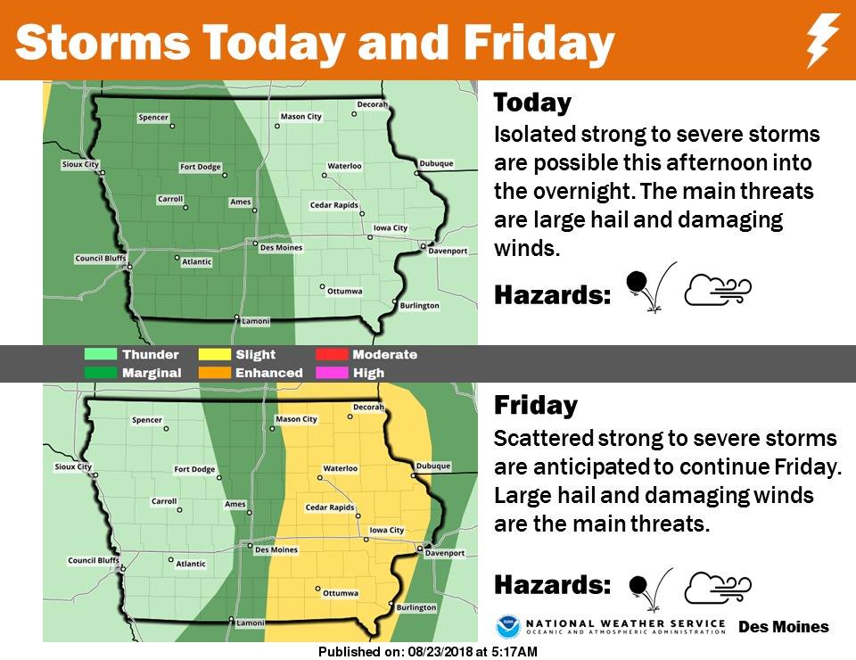 (Click on the image to enlarge)>>
Today: Partly cloudy to cloudy w/showers this afternoon. High 75. SE @ 10-15.
Tonight: Mostly cloudy w/showers & tstrms. Low 65. SE @ 5-10.
Tomorrow: Showers ending in the morning; Becoming P/Cldy. High 86. SW @ 10-15mph.
Saturday: P/Cldy. High near 90.
Sunday: P/Cldy w/isolated showers/strms. High 88.
Yesterday’s High in Atlantic was 78. Our Low this morning 51. Last year on this date our High was 79 and the Low was 49. The record High in Atlantic on this date was 99 in 1894. The Record Low was 36 in 1891.
Today: Patchy fog this morning; otherwise Mostly Sunny. High 80. W @ 10.
Tonight: Partly cloudy. Low 58.
Tomorrow: P/Cldy to Cldy w/a chance of afternoon showers. High 77. SE @ 10-15mph.
Friday: Cldy to P/Cldy w/a chance of morning showers & tstrms. High 82.
Saturday: P/Cldy. High 86.
Yesterday’s High in Atlantic was 74. Our Low this morning 51. Last year on this date our High was 76 and the Low was 48. The record High in Atlantic on this date was 100 in 1914. The Record Low was 41 in 1904.
OMAHA, Neb. (AP) — Residents and businesses in parts of eastern Nebraska and western Iowa are pumping out flooded basements and cleaning up the muck left behind from flooding caused by inch upon inch of rain. The National Weather Service reports that nearly a foot of rain fell on Woodbine, before stopping Monday afternoon. A two-day total in Omaha topped 8 inches.
Winds that accompanied the revolving storm front knocked down trees and limbs and knocked out power to thousands of homes. An estimated 3 feet of water covered some streets in Council Bluffs, stranding many motorists. Minor flooding from the rain and runoff is expected downstream on both sides of the Missouri River.
Today: Patchy fog through mid-morning; Partly Cloudy. High 78. N @ 10-20.
Tonight: Mostly clear. Low 54.
Tomorrow: Mostly sunny. High near 80. NW @ 10mph.
Thursday: P/Cldy to Cldy w/a chance of afternoon showers & thunderstorms. High 80.
Friday: Cldy to P/Cldy w/a chance of morning showers & tstrms. High 82.
Yesterday’s High in Atlantic was 73. We picked up .52” of rain (Storm total was 4.67”) Our Low was 60. Last year on this date our High was 82 and the Low was 59. The record High in Atlantic on this date was 100 in 1936. The Record Low was 40in 1956.


