
Sac-Calhoun-Crawford-Carroll-Greene-Boone-Audubon-Guthrie-Dallas-
Polk-Cass-Adair-Madison-Warren-Marion-Adams-Union-Clarke-Lucas-
Monroe-Taylor-Ringgold-Decatur-Wayne-Appanoose Counties….
534 AM CDT Wed May 15 2024
…Locally Dense Fog Through Sunrise…
Patchy fog has developed this morning over portions of central, western and southern Iowa. Visibilities below one mile have been observed in areas with a few locations dropping below one quarter of a mile. This fog is expected to persist through sunrise before some improvement. If traveling this morning, be prepared for rapid changes in visibilities over short distance and allow extra time to reach your destination.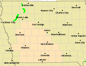
Today: Mostly cloudy w/areas of fog this morning; A slight chance of showers & thunderstorms. High near 71. Southeast winds 5 to 10 mph.
Tonight: Mo. cloudy w/a 50% chance of showers and thunderstorms.Low around 55.
Tomorrow: A slight chance of showers and thunderstorms in the morning, otherwise partly sunny. High 76. N/NW @ 5-10 mph.
Friday: Sunny, with a high near 79.
Saturday: Mostly sunny & breezy, w/a slight chance of afternoon showers and thunderstorms. High near 82.
Tuesday’s High in Atlantic was 78. Our Low was 49. Last year on this date, the High in Atlantic was 56 and the Low was 51. The Record High for May 15th was 91 in 1894 & 2017. The Record Low was 29 in 1929, 1973 & 1983. Sunrise: 6:02. Sunset: 8:32.
Today: Partly sunny, with a high near 73. North northeast wind 5 to 10 mph.
Tonight: Mostly cloudy, with a low around 51. East southeast wind 5 to 10 mph.
Tomorrow: A chance of showers & thunderstorms, otherwise partly sunny. High near 72. E/SE @ 5-10 mph.
Tom. Night: Showers/thunderstorms. Low around 54.
Thursday: P/Sunny w/a 50% chance of showers and thunderstorms. High near 76.
Friday: P/Sunny to Sunny, w/a slight chance of showers or thunderstorms. High near 79.
Monday’s High in Atlantic was 65. Our Low this morning was 49. We received .19″ of rain, Monday, at KJAN. Last year on this date, the High in Atlantic was 74 and the Low was 52. The Record High for May 14th was 97 in 2013. The Record Low was 29 in 1937. Sunrise: 6:03. Sunset: 8:31.
Today: Showers and possibly a thunderstorm. High near 66. N/NE winds 10-20 mph. New rainfall amounts between a quarter and half of an inch possible.
Tonight: Showers & thunderstorms ending this evening. Widespread haze developing before midnight, then gradual clearing. Low 48.
Tuesday: Sunny, with a high near 72. Northeast wind 10 mph.
Wednesday: A 60% chance of showers & thunderstorms. High near 71.
Thursday: A 30% of showers & possible thunderstorms; otherwise partly sunny, with a high near 73.
Sunday’s High in Atlantic was 81. The Low was 52. 24-hour rainfall (7-a.m. Sunday until 7-a.m. today), was .66″). Last year on this date, the High in Atlantic was 82 and the Low was 62. The Record High for May 13th was 95 in 1915. The Record Low was 23 in 1997. Sunrise: 6:04. Sunset: 8:30.
Today: Partly sunny w/a 40% chance of showers and thunderstorms, mainly after 3pm. High near 80. Southwest winds @ 5-10 mph. New rainfall amounts of less than a tenth of an inch, except higher amounts possible in thunderstorms.
Tonight: Showers and thunderstorms likely. Low around 57.
Monday: Showers likely and possibly a thunderstorm. High near 68. NE winds 10-20 mph.
Tuesday: Sunny, with a high near 74. North northeast wind 5 to 10 mph.
Wednesday: Partly sunny w/a 60% chance of afternoon showers & thunderstorms. High near 72.
Saturday’s High in Atlantic was 81. The Low was 41. Last year on this date, the High in Atlantic was 77 and the Low was 66. The Record High for May 12th was 94 in 1956. The Record Low was 25 in 1895. Sunrise: 6:06. Sunset: 8:29.
(Iowa & the Midwest) – Skywatchers who were away from city lights saw some awe-inspiring sights Friday night into early Saturday morning, as mostly clear skies allowed the Aurora Borealis/Northern Lights to make a stunning appearance. The images flooded social media. The event occurred due to a geomagnetic storm – called a coronal mass ejection, or CME – that was rated as level G5. This is the first G5-level storm since October 2003. The light show is expected to diminish late Sunday.
The source of the solar storm is a cluster of sunspots on the sun’s surface that is 17 times the diameter of the earth. The spots are filled with tangled magnetic fields that can act as slingshots, throwing huge quantities of charged particles towards our planet. Geomagnetic storms can impact infrastructure in near-Earth orbit and on Earth’s surface, potentially disrupting communications, the electric power grid, navigation, radio and satellite operations.
Unlike solar flares, which travel at the speed of light and reach Earth in around eight minutes, CMEs travel at a relatively more sedate pace, with officials putting the current average at 800km per second. Here are some of the pictures shared on the National Weather Service’s Facebook page:

St. Cloud, MN

Johnston, IA

Emmetsburg, IA

Brooklyn, IA

Boone County, IA

Greenfield, IA

Newton, IA
Today: Areas of fog this morning, otherwise partly cloudy to cloudy. High near 75. W/NW winds 10-20 mph.
Tonight: Mostly cloudy early, then gradually becoming clear. Low around 45. Northwest wind 5 to 10 mph.
Tomorrow: Sunny, with a high near 76. Northwest wind 5 to 10 mph.
Tom. Night: Partly cloudy, with a low around 51.
Sunday: Partly sunny w/a 40% chance of afternoon showers and thunderstorms. High near 80
Sunday Night: A chance of showers and thunderstorms. Low around 53.
Monday: A 50% chance of showers and thunderstorms early & then again in the afternoon, otherwise partly sunny. High near 70.
Thursday’s High in Atlantic was 71. Our Low this morning was 42. Last year on this date, the High in Atlantic was 83 and the Low was 58. The Record High was 97 in 2011. The Record Low was 26 in 1966. Sunrise: 6:07. Sunset: 8:27.


