Skyscan Forecast Wednesday, September 26, 2018 Dan Hicks
Today: Mostly sunny. W @ 10-15. High 68.
Tonight: Partly cloudy. SW @ 5-10. Low 48.
Thursday: Increasing clouds. SW @ 10-20. High 70.
Friday: Mostly cloudy. Light rain. High 62.
Saturday: Partly cloudy to cloudy. High 62.

Podcast: Play in new window | Download (365.9KB)
Subscribe: RSS
Skyscan Forecast Tuesday, September 25, 2018 Dan Hicks
Today: Mostly cloudy. Showers and a few isolated thunderstorms. Windy and cooler. NW @15-25. High 65.
Tonight: Clearing skies. Diminishing winds. Low 40.
Wednesday: Mostly sunny. W @ 10-15. High 68.
Thursday: Mostly cloudy. High 68
Friday: Mostly cloudy. A few showers. High 62.
Podcast: Play in new window | Download (647.9KB)
Subscribe: RSS
Skyscan Forecast Monday, September 24, 2018 Dan Hicks
Today: Partly cloudy. Warmer. S @ 10-20. High 82.
Tonight: Mostly cloudy. Scattered showers and thunderstorms. S @ 10. Low 60.
Tuesday: Mostly cloudy. Windy and cooler. Showers. NW @ 15-25. High 64.
Wednesday: Mostly sunny. High 68.
Thursday: Mostly cloudy. High 66.
Podcast: Play in new window | Download (728.4KB)
Subscribe: RSS
Today: Sunny, with a high near 76. South wind 5 to 13 mph, with gusts as high as 18 mph.
Tonight: Clear, with a low around 55. South southeast wind around 8 mph.
Monday: Mostly sunny, with a high near 79. South wind 8 to 14 mph, with gusts as high as 22 mph.
Monday Night: A slight chance of showers and thunderstorms, then showers likely and possibly a thunderstorm after 1am. Mostly cloudy, with a low around 57. South wind 5 to 7 mph becoming north northwest after midnight. Chance of precipitation is 60%. New rainfall amounts between a tenth and quarter of an inch, except higher amounts possible in thunderstorms.
Tuesday: A chance of showers and thunderstorms. Mostly cloudy, with a high near 68. North wind 6 to 13 mph, with gusts as high as 18 mph. Chance of precipitation is 50%. New rainfall amounts between a tenth and quarter of an inch, except higher amounts possible in thunderstorms.
Tuesday Night: Partly cloudy, with a low around 45.
Wednesday: Sunny, with a high near 65.
Yesterday’s High in Atlantic was 71. The Low was 40. Last year on this date our High was 91 and the Low was 64. The record High in Atlantic on this date was 99 in 1892. The Record Low was 23in 1983.
Today: Areas of fog this morning, otherwise mostly sunny. High near 70. S @ 10-15.
Tonight: Partly cloudy. Low around 48. S @ 5-10.
Tomorrow: P/Cldy. High 78. S @ 10-20.
Monday: P/Cldy. High around 80.
Tuesday: Mostly cloudy w/a chance of showers. High around 68.
Yesterday’s High in Atlantic was 67. Our Low this morning was 40. Last year on this date our High was 92 and the Low was 70. The record High in Atlantic on this date was 98 in 1937. The Record Low was 27 in 1974, 1995 & 2012.
(Radio Iowa) — Powerful winds and heavy rain hit northwest Iowa last (Thursday) night, leaving a mess behind. Emmet County was one of the areas hit hardest with destructive winds and heavy rainfall. There were reports of power outages, as well as numerous trees and branches down.
Extensive damage occurred at the Green Plains ethanol plant office in Superior, and damage to equipment and trucks was reported to have taken place at the Superior Co-op. Part of the roof was torn off, along with blown out windows and an outside wall was ripped off the structure.
There were also reports of buildings and homes in the Estherville area that sustained extensive damage. As a precaution, several businesses along Central Avenue were evacuated because of a natural gas leak. Iowa Lakes Community College evacuated students from two dorm buildings due to downed power lines. All students were safe and were able to return to the dorms later in the evening.
Floodwaters have filled basements, home and business floors and closed streets and highways in northwest Iowa. The National Weather Service says the Little Sioux River is expected to crest Friday at just under 7 feet above flood stage in Spencer. More than 7 inches of rain has been reported west of the city from storms Wednesday into Thursday. U.S. Highway 18 was closed for a time east of Spencer.
Up to 7 inches also was reported in Hartley, where Mayor Rod Ahrenstorff says several inches fell earlier this week and then again Wednesday night into Thursday. City clerk and administrator Patty Anderson says she’s worried about what the flooding is going to cost the city.
Today: Partly cloudy, windy & cooler. High 68. NW @ 15-25.
Tonight: Clear. Diminishing winds. Low 40.
Tomorrow: Mostly sunny. High 72. S @ 5-10.
Sunday: P/cldy. High 78.
Monday: P/cldy w/a chance of afternoon showers/thunderstorms. High near 80.
Yesterday’s High in Atlantic was 92. Our Low this morning 57. We received .65” rain last night, in Atlantic. Last year on this date our High was 90 and the Low was 67. The record High in Atlantic on this date was 96 in 1937. The Record Low was 29 in 1918 & 1994.
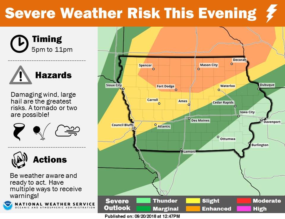
A line of showers and thunderstorms is expected to move from northwest to southeast across the area late this afternoon into tonight. Storms are expected to develop around 4-5pm across far northwest Iowa. Storms will move rapidly to the southeast with the peak impacts between 6pm and 11pm. Damaging winds, large hail and frequent lightning are the primary concerns. A tornado or two is also possible, although the higher tornado risk has shifted north into Minnesota. While a brief period of heavy rainfall is possible as the storms move through, the faster movement of storms should limit the flash flood threat. The greatest threat for severe weather is over the northern third of Iowa, with areas from Atlantic to Council Bluffs northward, to Carroll and east to Ames under a slight risk.