
Cass County Sheriff’s Deputies are reporting flash flooding in parts of the County early this morning. Flooding over the roads was reported west of Massena, among other locations. Drivers should use extreme caution while venturing out today. Be prepared to encounter flooded roads. Remember to “Turn around. Don’t Drown!” If you see water over the road.

720TH between Victoria & Tucson Roads near Massena.

Photos courtesy the Cass County Sheriff’s Dept.

Montgomery-
Including the city of Red Oak
334 AM CDT Fri May 24 2019
…FLASH FLOOD WATCH IN EFFECT FROM 7 AM CDT THIS MORNING THROUGH
SATURDAY MORNING…
The National Weather Service in Omaha/Valley has expanded a Flash Flood Watch from Fremont and Page Counties to include Montgomery County.
* From 7 AM CDT this morning through 7-a.m. Saturday
* A prolonged period of thunderstorms is expected this morning through Saturday morning. Some locations could see over an inch of additional rainfall. This rainfall will occur on already saturated soils, so the potential for flash flooding will
increase.
* Low-lying and flood-prone areas will be most susceptible to the dangers of flash flooding. Areas near rivers, creeks, and streams could become flooded during and immediately after heavy rainfall.
PRECAUTIONARY/PREPAREDNESS ACTIONS…
A Flash Flood Watch means that conditions may develop that lead to flash flooding. Flash flooding is a very dangerous situation. You should monitor later forecasts and be prepared to take action should Flash Flood Warnings be issued.
Today: Partly cloudy. High 72. E @ 10.
Tonight: Mostly Cloudy w/showers & thunderstorms overnight. Low 60. SE @ 5-10.
Tomorrow: P/Cldy to cldy w/scattered shwrs & tstrms. High 76. S @ 10-20.
Saturday: P/Cldy to Cldy w/scattered showers & tstrms. High around 76.
Sunday: P/Cldy to Cldy w/scattered shwrs & tstrms. High near 72.
Monday: Variably cloudy w/scattered shwrs. High in the mid-70’s.
Yesterday’s High in Atlantic was 67. Our Low 46. Last year on this date our High was 88 and the Low was 66. The record High in Atlantic on this date was 97 in 1939. The Record Low was 26 in 1963.
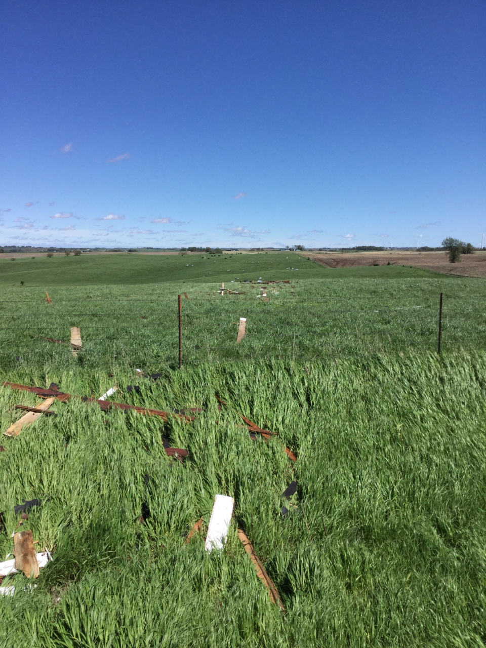
The National Weather Service said Wednesday afternoon, another tornado was determined to have occurred southeast of Anita, Wednesday morning, prior to the fatal twister that occurred south/southeast of Adair. The Anita tornado actually occurred around 25 minutes before the Adair tornado and demolished an old barn, tossing debris about one third of a mile downstream. The remainder of the path was across rural cropland with a total path length of just over one mile.
The Anita tornado which started at around 1:04-a.m., 2.6-miles south/southeast of Anita, was rated an EF-1, with estimated peak winds of 90-to 100 MPH. It’s 50-yard wide path was 1.1-miles long, and ended at around 1:06-a.m. 1.6-miles southeast of Anita. (For more info.: https://www.weather.gov/dmx/20190522_Tornadoes)
(All photos by NWS Damage Survey Team)
Anita – Debris Downwind
Barn near Anita
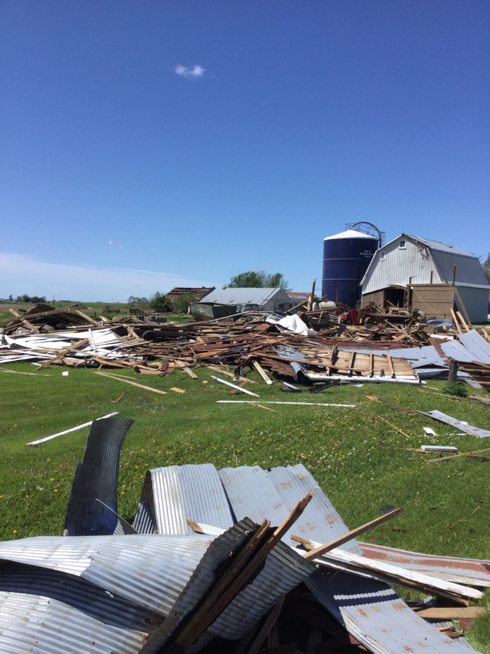
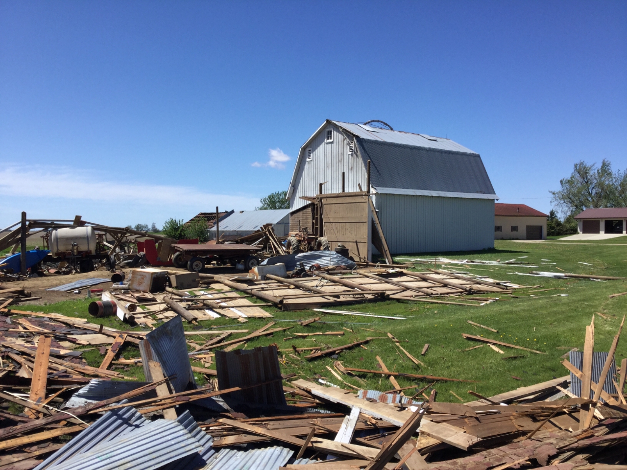
The National Weather Service in Des Moines spent the morning assessing the damage caused during a storm early this morning, in northwestern Adair County. One person died and another was injured during what the preliminary investigation determined was a STRONG (EF-2) Tornado, with estimated peak winds of 120-to 130 MPH.
Officials say “A tornado developed quickly 3.2 miles south southeast of Adair, Iowa early Wednesday morning, May 22nd, 2019 resulting in one fatality and one injury. A rural homestead located just south of Interstate 80 received extensive damage to a single-family residence and outbuildings. The damage survey team also found lesser damage to single family residences and outbuildings located south of the main impacted home.”

Main Residence outbuildings-1
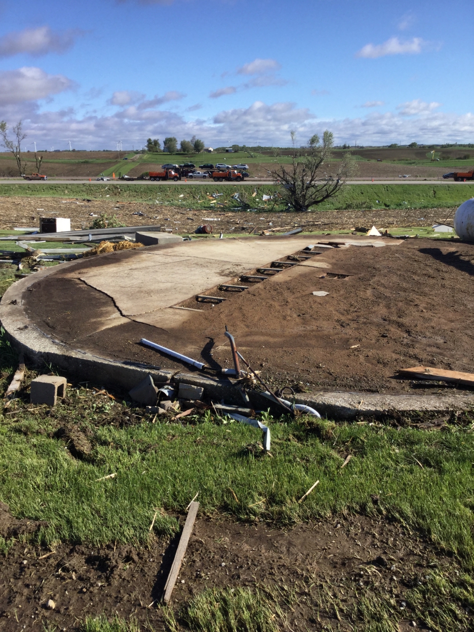
Main Residence GrainBinFoundation-1

Main residence (Adair Tornado) – Outbuildings (All photos by NWS Damage Survey Team)
The twister’s path was 4.8-miles, and 150-yards wide. It’s estimated to have begun at 1:29-a.m. 3.2 miles south-southeast of Adair, and ended at around 1:37-a.m., 2.2-miles northeast of Adair. 74-year old Linda Lee Brownlee died at the scene. Her husband, 78-year old Harold Brownlee suffered serious injuries, and was flown to a hospital in Des Moines. Debris from their home landed on nearby Interstate 80, at mile marker 77. One semi was in the ditch at about the same location.
Meteorologist Chad Hahn, with the National Weather Service, says it’s very unusual to have a twister strike that early in the morning. He says only about five-percent of tornadoes hit during the nighttime. While May, June and July are typically the worst months of the year for tornadoes in Iowa, this is the first confirmed tornado this year. Last year, there were 69 tornadoes statewide with the most notable hitting Bondurant, Marshalltown and Pella on July 19th. Over the past decade, Iowa has seen as few as 16 tornadoes during all of 2012 and as many as 88 tornadoes in 2014.
Law enforcement reported to KJAN that numerous power poles were down this (Wednesday) morning across rural roads in eastern Cass County. A motorist drove over one of the power lines at around 4-a.m. on Glendale/Fairview Road, between 750th (Highway 148) and 760th Streets. Building debris from a barn was scattered along Glendale Road, but has since been removed. Cass County Emergency Management Coordinator Mike Kennon encourages residents who sustained storm damage to contact him at 254-1500. For more information on the tornado: https://www.weather.gov/dmx/20190522_Tornadoes
*****************
EF Scale: The Enhanced Fujita scale classifies tornadoes in
the following categories.
EF0…Weak……65 TO 85 MPH
EF1…Weak……86 TO 110 MPH
EF2…Strong….111 TO 135 MPH
EF3…Strong….136 TO 165 MPH
EF4…Violent…166 TO 200 MPH
EF5…Violent…>200 MPH
(9-a.m., Radio Iowa) — What may be Iowa’s first tornado of 2019 claimed a life early this (Wednesday) morning in the southwest corner of the state. Meteorologist Chad Hahn, with the National Weather Service, says there is storm damage in Adair and Cass counties and at least one house was destroyed south of the city of Adair. Reports say several other homes were impacted. “We’re still evaluating that,” Hahn says. “We have a storm team that’s out in the area evaluating and assessing the damage. The one homestead that we know was hit was close to the interstate, which was closed down for a time in the early morning hours.”
Adair County authorities say 74-year-old Linda Brownlee was killed in the storm and her husband, 78-year-old Harold Brownlee, was seriously hurt and is hospitalized in Des Moines. Hahn says the team surveying the wreckage will be working to determine whether the destruction was caused by a tornado or straight-line winds. “The biggest signs that we look for is the damage pattern within the debris,” Hahn says. “We can evaluate whether there is a rotational component to that and that’s what they’re examining out there right now.”
If it was a tornado, Hahn says it’s very unusual to have a twister strike at that hour, sometime between 12:30 and 1:30 A-M. He says only about five-percent of tornadoes hit during the nighttime. The risk of more severe weather today is low, but Hahn says the chances are a bit higher Thursday, especially in southeast Iowa. “As we look into Friday, we can expect portions of the southeastern part of the state to be in that area where conditions will be favorable for severe weather,” Hahn says. “It’s late May. We know the conditions around here are becoming more susceptible to severe weather and we need to stay on guard.”
While May, June and July are typically the worst months of the year for tornadoes in Iowa, this would be the first confirmed tornado this year. Last year, there were 69 tornadoes statewide with the most notable hitting Bondurant, Marshalltown and Pella on July 19th. Over the past decade, Iowa has seen as few as 16 tornadoes during all of 2012 and as many as 88 tornadoes in 2014.
ADAIR, Iowa (AP) — Authorities suspect a tornado destroyed a house and damaged other buildings on a farmstead in southwest Iowa’s Adair County. No injuries have been reported. The incident was reported around 1:30 a.m. Wednesday, 2 miles east-southeast of Adair. The National Weather Service says debris from the farmstead landed on Interstate 80. The tornado sighting has not yet been confirmed.
Law enforcement reported to KJAN that numerous power poles were down this morning across rural roads in eastern Cass County. A motorist drove over one of the power lines at around 4-a.m. on Glendale/Fairview Road, between 750th (Highway 148) and 760th Streets.
Today: Partly cloudy w/a slight chance of rain this morning. High 68. SW @ 15-25.
Tonight: P/Cldy to Cloudy. Low 48. W @ 5.
Tomorrow: P/Cldy to cldy. High 70. NW @ 10.
Friday: P/Cldy to Cldy w/scattered showers & tstrms. High around 75.
Saturday: P/Cldy to Cldy w/scattered light rain. High near 75.
Yesterday’s High in Atlantic was 58. Our Low 46. We received 1.05” of rain yesterday through the overnight hours of today. Last year on this date our High was 78 and the Low was 58. The record High in Atlantic on this date was 98 in 1905. The Record Low was 28 in 1895 & 1963.
Drivers should exercise extreme caution this morning, if traveling on roads between the Cass and Adair County lines. Law enforcement reports several downed power lines, with multiple posts/poles sucked out of the ground. A severe thunderstorm warning was issued for the area at around 12:45-a.m. One motorist drove over a downed power line on Glendale Road between 750th and 760th just before 4-a.m. The National Weather Service is sending a survey team to assess the damage and determine whether it was straight line winds or a possible tornado that caused the destruction.


