
Today: Increasing cloudiness w/a 30% chance of showers and thunderstorms, mainly after 1pm. High near 87. S/SW winds 10-20 mph. New rainfall amounts of less than a tenth of an inch, except higher amounts possible in thunderstorms.
Tonight: Showers and thunderstorms likely, through about midnight. Low around 65. Winds becoming light and variable. Chance of precipitation is 60%. New rainfall amounts between a half and three quarters of an inch possible.
Monday: A 50 percent chance of showers and thunderstorms, mainly after 7am., otherwise Partly sunny, with a high near 82. Light and variable wind becoming N/NW @ 10-20 mph. New rainfall amounts between a tenth and quarter of an inch, except higher amounts possible in thunderstorms.
Tuesday: Sunny, with a high near 78.
Wednesday: Sunny, with a high near 83.
Yesterday’s high was 82 and last night’s low was 61. This day last year we had a high of 79 and a low of 65. The all-time record high on June 21st was 101 degrees set in 1988 and the record low was 38, in 1902. Sunset tonight is at 8:57am and sunrise tomorrow is 5:46 am.

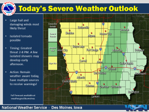
Today and tonight: Rain showers may develop early this afternoon. Mid to late afternoon, stronger thunderstorms are forecast to develop. A few storms may be severe producing large hail and damaging wind gusts. An isolated tornado is possible. In addition, heavy rainfall is possible with stronger thunderstorms. This may lead to flooding issues in areas that have seen heavier rainfall over the past few
days. Local creeks and streams may also rise to the top of their banks.
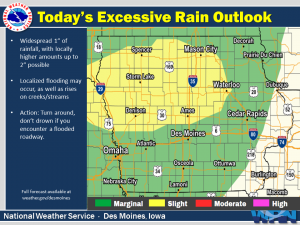 Monday through Saturday: Rain showers and thunderstorms are forecast to continue into Monday. The main concern will be the potential for flooding due to heavy rainfall. At this time, there does not appear to be a notable severe threat with thunderstorms on Monday.
.SPOTTER INFORMATION STATEMENT…
Spotter reports may be needed if severe thunderstorms develop. Rainfall reports would be greatly appreciated this afternoon.
Skyscan Forecast Saturday, June 20, 2020 Dan Hicks
Today: Partly cloudy to cloudy. Scattered showers and thunderstorms later this morning and afternoon. Variable winds 5-10. High 78.
Tonight: Mostly cloudy. Scattered showers and thunderstorms ending. N @ 5-10. Low 60.
Sunday: Partly cloudy to cloudy. Scattered showers and thunderstorms by mid to late afternoon. SE @ 10-15. High 84.
Monday: Mostly cloudy. Showers and thunderstorms. High 78.
Tuesday: Partly cloudy. High 78.
Podcast: Play in new window | Download (696.2KB)
Subscribe: RSS
Skyscan Forecast Saturday, June 19, 2020 Dan Hicks
Today: Partly cloudy to cloudy. Showers and thunderstorms ending this morning, then redeveloping in the afternoon. N @ 10-15. High 78.
Tonight: Mostly cloudy. Scattered showers and thunderstorms. Light E winds. Low 63.
Saturday: Mostly cloudy. Scattered showers and thunderstorms. E @ 10-15. High 78.
Sunday: Partly cloudy. Scattered showers and thunderstorms in the afternoon. High 82.
Monday: Mostly cloudy. Showers and thunderstorms in the morning. High 78.
Podcast: Play in new window | Download (680.9KB)
Subscribe: RSS
Skyscan Forecast Thursday, June 18, 2020 Dan Hicks
Today: Partly cloudy. Scattered showers and thunderstorms possible later in the afternoon. S @ 15-30. High 90.
Tonight: Mostly cloudy. Scattered showers and thunderstorms. NW @ 5-10. Low 64.
Friday: Mostly cloudy. Scattered showers and thunderstorms. N @ 10-15. High 80.
Friday night: Mostly cloudy. Showers and thunderstorms. Low 63.
Saturday: Variable cloudiness. Scattered showers and thunderstorms. High 80.
Sunday: Variable cloudiness. A few lingering showers. High 80.
Podcast: Play in new window | Download (796.3KB)
Subscribe: RSS
Skyscan Forecast Wednesay, June 17, 2020 Dan Hicks
Today: Mostly sunny. S @ 15-30. High 92.
Tonight: Partly cloudy. S @ 10-15. Low 68.
Thursday: Partly cloudy. Scattered showers and thunderstorms developing in the afternoon. S @ 15-30. High 92.
Friday: Variable cloudiness. Scattered showers and thunderstorms. High 83.
Saturday: Variable cloudiness. Scattered showers and thunderstorms. High 83.
Podcast: Play in new window | Download (684.3KB)
Subscribe: RSS
Skyscan Forecast Tuesday, June 16, 2020 Dan Hicks
Today: Partly cloudy. S increasing to 15-30. High 92.
Tonight: Partly cloudy. SE @ 10-15. Low 68.
Wednesday: Partly cloudy. S @ 15-30. High 92.
Thursday: Partly cloudy. Afternoon scattered showers and thunderstorms. High 90.
Friday: Variable cloudiness. Scattered showers and thunderstorms. High 85.
Podcast: Play in new window | Download (667.8KB)
Subscribe: RSS
Skyscan Forecast Monday, June 15, 2020 Dan Hicks
Today: Partly cloudy. Isolated shower possible in the morning. S @ 15-30. High 90.
Tonight: Partly cloudy. S @ 10-15. Low 68.
Tuesday: Partly cloudy. S @ 15-30. High 92.
Tuesday Night: Mostly clear. Low 69.
Wednesday: Partly cloudy. High 92.
Thursday: Partly cloudy. Isolated showers and thunderstorms developing. High 90.
Yesterday’s high was 86 and last night’s low was 62. This day last year we had a high of 85 and a low of 58. The all-time record high was 99 degrees set in 1918 and the record low was 40 set back in 1906 and 1969. Sunset tonight is at 8:56am and sunrise tomorrow is the same as today at 5:45am.
Podcast: Play in new window | Download (641.5KB)
Subscribe: RSS
Sunday: Partly sunny, with a high near 86. Windy, with a south southeast wind 13 to 23 mph, with gusts as high as 33 mph.
Sunday Night: Mostly cloudy, with a low around 66. Breezy, with a south southeast wind 13 to 20 mph, with gusts as high as 28 mph.
Monday: Mostly sunny, with a high near 91. Breezy, with a south wind 13 to 20 mph, with gusts as high as 28 mph.
Monday Night: Partly cloudy, with a low around 69. Breezy, with a south southeast wind 11 to 16 mph, with gusts as high as 23 mph.
Tuesday: Sunny, with a high near 92. Breezy.
Tuesday Night: Mostly clear, with a low around 70. Breezy.
Wednesday: Sunny, with a high near 93. Breezy.
Saturday’s High in Atlantic was 89. Our Low was 58. Last year on this date, the High was 81 and the Low 62. The Record High in Atlantic on June 14th was 97 in 1987. The Record Low was 41 in 1937.


